Printed version ISSN 0001-3765 / Online version ISSN 1678-2690 http://dx.doi.org/DOI: 10.1590/0001-3765201620140641
www.scielo.br/aabc
Holocene paleo-sea level changes along the coast of Rio de Janeiro,
southern Brazil: Comment on Castro et al. (2014)
RODOLFO J. ANGULO¹, PAULO C.F. GIANNINI², MARIA CRISTINA DE SOUZA¹ and GUILHERME C. LESSA³ ¹ Centro Politécnico, Departamento de Geologia, UFPR, Laboratório de Estudos Costeiros/Lecost, Av.
Cel. Francisco H. dos Santos, 210, Jardim das Américas, 81531-970 Curitiba, PR, Brazil ²Instituto de Geociências, USP, Rua do Lago, 562, Cidade Universitária, 05508-080 São Paulo, SP, Brazil
³Grupo de Oceanografia Tropical/GOAT, UFBA, Travessa Barão de Jeremoabo, s/n, Campus Universitário de Ondina, LFNA, sala 02, 40170-280 Salvador, BA, Brazil
Manuscript received on December 15, 2014; accepted for publication on March 16, 2015
ABSTRACT
The present work discusses and reinterprets paleo-sea level indicators used to build Holocene sea-level
curve for the coast of Rio de Janeiro at former works. We conclude that: (a) the paleo-sea levels inferred
by vermetid remains show that sea-level has fallen over the past 4400 years, at least; (b) the paleo-sea
level inferred by the beachrock facies and dated shells of Jaconé shows that sea-level was near the present
elevation between 8198 and 5786 years before present; and (c) several shells from other beachrocks were
deposited probably thousands of years after the specimens died and consequently do not allow precise
reconstructions of paleo-sea levels. These conclusions differ from the conclusions of the original paper.
Key words:
Beachrock, paleo-sea level reinterpretation, sea-level curve, vermetids,
Tetraclita stalactifera
.
Correspondence to: Rodolfo José Angulo E-mail: [email protected]
INTRODUCTION
Investigations of relative sea-level changes at local
and regional scales are important to distinguish the
impact of land tectonics and isostasy from those
of eustatic sea level changes. This works aims to
comment and provide alternative interpretations to
the data used by Castro et al. (2014) to discuss the
behavior of the paleo-sea level at Rio de Janeiro
coast during the Mid to Late Holocene.
RESULTS AND DISCUSSION
Castro et al. (2014) paper presents new relevant
information to aid with Holocene relative
sea-level (RSL) reconstructions along the coast of
Rio de Janeiro. The data set is extensive (29 listed
indicators, out of which 14 were used in the sea
level curve) and from different sources. However,
there are several problems that compromise the
authors’ interpretations and final conclusions.
The first concerns, and perhaps the most
compromising, is related to the paleo-sea level
reconstruction. The authors mistake the altitude of
the indicators as the paleo-sea level. As a result,
their final paleo-sea level curve is not a relative
curve but a curve showing the altitude of the
paleo-sea level indicators (vermetids and beachrock
shells).
defining the altitude of the biological and geological
samples in reference to “zero” (i.e., the current
mean sea-level)
. It has been well known since
the seminal papers of Hartt (1870) and Branner
(1902, 1904) that paleo-sea level reconstructions
must consider the vertical distance between a given
indicator and its present homologous one. For
example Branner (1902, 1904) compares the upper
limit of former urchin holes with the upper limit
of living urchins. As this distance is around 2 m
the author correctly concludes that the older urchin
holes indicate a paleo-sea level 2 m higher than the
present one. Hence, there is no need to determine the
present mean-sea level. This procedure was largely
accepted and is described in several manuals on
sea-level reconstructions (e.g. Martin et al. 1982,
Van de Plassche 1986, Pirazzoli 1996).
Castro et al. (2014) also postulate that
several
investigations conducted on the South American
coasts regarding relative sea-level variations have
not clearly or precisely defined the reference level
of the samples used in the vertical plane.
This is
true because it is not necessary. The authors stress
that
the absence of this information yields potential
inaccuracies regarding the height of the marine
paleo-levels of the proposed curves
. That, on the
other hand, is incorrect because the inaccuracies in
defining paleo-sea levels are related to the intrinsic
characteristics of the given indicator, its vertical
spread and the uncertainty related to where, within
this spread, the remains are from. It is not related
to the accuracy of determining the present
mean-sea level. On the same line the authors also stress
that the field method applied for estimating the
elevations of the samples (GPS trackers)
has a very
small margin of error and therefore suggest that
the
method employed in this study would need to be
applied to other parts of the Brazilian coastline
. We
emphasize that this procedure is not necessary, and
that efforts must concentrate on the determination
of the vertical distance between the paleo-sea
level indicators and their living homologous one.
Moreover, the error inherent to the paleo-sea level
indicator is tens to hundreds of times larger than the
measurement error associated with GPS trackers.
Other worth-mentioning confusions in the
paper are:
(1) The authors assertion that their
results
confirm other data already obtained elsewhere
along the Atlantic coast of South America.
This
is not possible because along the Atlantic coast of
South America there are divergent data (e.g. Martin
et al. 2003, Angulo et al. 2006), including a former
Castro et al. (2012) paper where it is postulated that
at 13,130 calibrated years before present (cal a BP)
level at Cabo Frio was 1.5 m above present
sea-level. Furthermore, it is remarkable that those two
comprehensive papers about Holocene sea-level
changes along the Brazilian coast (Martin et al.
2003, Angulo et al. 2006) have not been referenced.
In addition, several paleo-sea level reconstructions
from the state of Rio de Janeiro were not even
mentioned, including those from Cabo Frio region
published in former works (Laborel 1969, Delibrias
and Laborel 1969, Martin et al. 1979, 1979/80,
1983, 1984, 1996, 1997, Martin and Suguio 1978,
1989, Maia et al. 1984, Table I) and used by
Angulo et al. (2006) to build the Brazilian sea-level
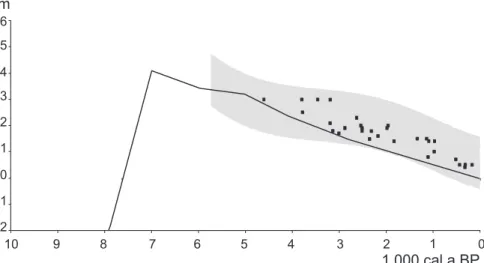
envelope from Pernambuco to Paraná (Fig. 1)
(2) The authors inform that the vermetid
used as a paleo-sea level indicator corresponds
to
Laguncularia racemosa
. This is a mangrove,
not vermetid, species. Probably the vermetid
found at Cabo Frio corresponds to
Petaloconchus
(Macorphragma) varians
, the most common
vermetid species along the Brazilian coast.
(3) The authors inform that
eight percussion
drills were performed perpendicular to the coastline
within the study area
, but no data or interpretation
of those cores are presented in the paper.
as to which listed samples the points in the curve
correspond to.
(5) We note a divergence between the results in
the paper under discussion and those from Castro
et al. (2012), in regard to the ages attributed to two
samples of shells from beachrocks: 7910-7690
14C
cal a BP in Castro et al. (2014) and 12,910-12,690
14
C cal a BP in Castro et al. (2012) (Beta Analytic
248722), and 3130-2860
14C cal a BP at Castro et
al. (2014) and 13,130-12,860
14C cal a BP at Castro
et al. (2012) (Beta Analytic 248723). These incon
-sistencies are not justified by Castro et al. (2014).
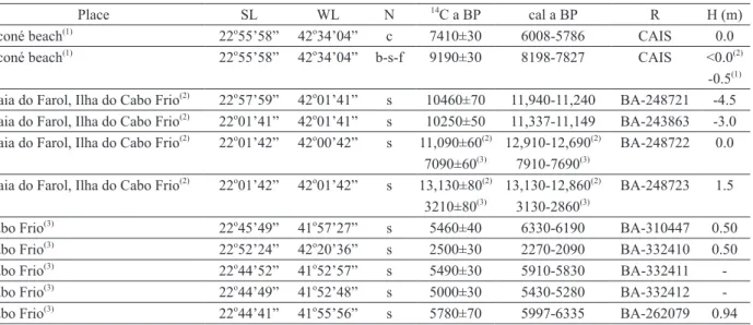
TABLE IPaleo-sea levels inferred from vermetids and barnacles remains from the coast of Rio de Janeiro.
Place SL WL N 14
C a BP cal a BP R H (m) PSL (m) Ilha Grande(1,2)
23o
08’ 44o
10 v 380±90 0(9)
Gif-1061 - 0.5±1.0(9)
Ilha Grande(1,2)
23o
00,0’ 45o
00,0’ v 1670±100 1401-983(9)
Gif 1060 - 1.5±1.0(9)
Ilha Grande(1,2)
23o
08’ 44o
10’ v 3420±110 3536-2970(9)
Gif-1059 - 3.0±1.0(9)
Cabo Frio(1,2)
22o
54,3’ 42o
00,0’ v 2400±95 2283-1814(9)
Gif-1935 - 2.0±1.0(9)
Cabo Frio(1,2) 22o54,3’ 42o00,0’ v 3900±110 4155-3564(9) Gif-1934 - 3.0±1.0(9) Praia de Mambucaba(3,4,5,6)
23o
02,2’ 44o
33,2’ v 1840±90 1581-1211(9)
Bah-471 - 1.5±1.0(9)
Tarituba(3,6)
23o
02,9’ 44o
36,7’ v 975±80 674-447(9)
Bah-478 - 0.7±1.0(9)
Parati-Mirim(3)
23o
14,8’ 44o
37,6’ v 1490±80 1221-884(9)
Bah-482 - 1.0±1.0(9)
Mangaratiba(3)
22o
58,2’ 44o
02,8’ v 1630±65 1296-1030(9)
Bah-499 - 0.8±1.0(9)
Mosuaba(3)
23o
01,0’ 44o
13,3’ v 230±60 0(9)
Bah-483 - 0.5±1.0(9)
Ilha do Araújo(3)
23o
09,2’ 43o
41,8’ v 2300±85 2110-1698(9)
Bah-470 - 1.4±1.0(9)
Coroa Grande(3) 22o55,7’ 43o50,6’ v 2595±90 2494-1997(9) Bah-473 - 1.6±1.0(9) Frade(3)
22o
58,7’ 44o
26,3’ v 2695±130 2722-2081(9)
Bah-465 - 1.5±1.0(9)
Mangaratiba(3) 22o57,8’ 44o02,6’ v 3255±100 3320-2815(9) Bah-472 - 1.7±1.0(9) Praia do Meio(5)
23o
21,2’ 44o
43,3’ v 390±100 0(9)
Bah-488 - 0.4±1.0(9)
Praia Grande(5)
23o
09,2’ 44o
41,8’ v 500±80 262-0(9)
Bah-489 - 0.5±1.0(9)
Prainha, Arraial do Cabo(6.7)
22o
57,6’ 42o
01,2’ v 2680±180 2771-1924(9)
Bah-1298 - 1.8±1.0(9)
Praia da Ferradura, Buzios(6,7)
22o
46,2’ 41o
53,0’ v 3360±180 3603-2761(9)
Bah-1306 - 1.8±1.0(9)
Praia João Fernandes, Búzios(6,7)
22o
44,3’ 41o
51,3’ v 3420±190 3698-2781(9)
Bah-1304 - 2.1±1.0(9)
Ponta do Retiro(6,7)
21o
21,6’ 40o
57,6’ v 3620±150 3895-3140(9)
Bah-1008 - 3.0±1.0(9)
Cabo Frio - Búzios(8) 22o44’47” 41o52’53” v 2810±95 2745-2321 L-11A 1.50 2.0±1.0(10) Cabo Frio - Búzios(8)
22o
44’51” 41o
52’49” v 3050±80 3050-2683 BA-259845 1.43 1.9±1.0(10)
Cabo Frio - Búzios(8)
22o
44’45” 41o
52’57” v 2760±70 2686-2325 BA-259846 1.31 1.8±1.0(10)
Cabo Frio - Búzios(8)
22o
44’48” 41o
52’51” v 2890±60 2780-2453 BA-259847 1.81 2.3±1.0(10)
Cabo Frio - Búzios(8)
22o
44’43” 41o
52’50” v 2760±70 2686-2325 BA-259848 1.38 1.9±1.0(10)
Cabo Frio - Búzios(8)
22o
52’47” 42o
01’08” b 3820±70 3960-3581 BA-259849 2.0 2.5±1.0(10)
Cabo Frio - Búzios(8)
22o
52’41” 42o
01’03” v 4400±60 4771-4409 BA-259850 2.5 3.0±1.0(10)
Cabo Frio - Búzios(8) 22o52’40” 42o01’09” v 2350±70 2153-1798 BA-262078 1.37 1.9±1.0(10) Cabo Frio - Búzios(8)
22o
47’19” 41o
55’57” v 1410±40 1040-890 BA-270651 0.85 1.4±1.0(10)
Cabo Frio - Búzios(8)
22o
47’19” 41o
55’57” v 1540±40 1180-1000 BA-270650 0.90 1.4±1.0(10)
Sources: (1) Laborel 1969, (2) Delibrias and Laborel 1969, (3) Martin and Suguio 1978, (4) Martin et al. 1979, (5) Martin et al. 1979/80, (6) Martin and Suguio 1989, (7) Martin et al. 1997, (8) Castro et al. 2014, (9) after Angulo et al. 2006, (10) this paper. Notes: (SL) South latitude, (WL) West longitude, (N) sample nature, (14
Considering the indicators presented by Castro
et al. (2014), it is possible to suggest the following
interpretations:
(a) Vermetids and
Tetraclita stalactifera
Vermetids and
Tetraclita stalactifera
live
next to the low water level (see e.g. van Andel
and Laborel 1964, Laborel 1979, 1986), or about
0.5 m below mean-sea level in Cabo Frio, where
the tide range is around 1 m. Therefore, to infer
a paleo-sea level from remains of vermetids or
Tetraclita stalactifera
it is necessary to add 0.5
m (the difference between mean and low tide
levels) to their altitude. However, the altitude of
the living zone of vermetids also depends on wave
exposure (Laborel 1969, 1986) and morphology
of rocky coast (Delibrias and Laborel 1969). This
is why it is necessary to compare the old remains
with living organisms at similar tidal and wave
exposure conditions, taking into account that those
conditions might have changed since the organisms
died (Angulo et al. 1999). It is also necessary
to assess to which part of the vermetid reef (it
can span more than 1m vertically) the remains
correspond to (Angulo et al. 1999). Therefore, the
margin of error could range between ± 0.1 m to 1.0
m (Laborel 1969, 1986, Angulo et al. 1999). The
paleo-sea level reconstructions from vermetids and
Tetraclita stalactifera
from Cabo Frio, considering
an error margin of ± 1.0 m, fit with reconstructions
published elsewhere, such as the curve presented
by Angulo et al. (2006) and the models for eustatic
sea-level variations proposed by Milne et al. (2005)
for this same region (Fig. 1 and Table I).
(b) Shells from beachrocks
Shells older than 7.000 years BP were collected
from beachrocks (Table II). To infer paleo-sea
levels from this indicator it is necessary to consider
that shells can be older than the beachrock and
therefore provide only a maximum age. Castro et al.
(2014) did not consider this premise. This common
misunderstanding led the authors to suggest that
sea level was 4.5 m below the current one between
11,000 and 12,000 years BP, and in addition to
claim that
this is the first identified negative
sea-level record during Late Pleistocene and Early
Holocene transition on the Brazilian coast.
This
interpretation does not fit with the wide accepted
global sea-level curves (e.g. see Pirazzoli 1996),
which indicate that at that time, sea-level was still
ascending at full throttle and was tens of meters (30
to 90 m) lower than the present one. Therefore, it
is possible to deduce that the dated shells contained
in the beachrock are thousands of years older than
the sedimentary deposit itself. This is a common
issue and has been verified on Holocene barriers
everywhere, including Brazil where vegetal
debris are up to 5 thousand years older than the
sedimentary deposit (Angulo et al. 2008).
TABLE II
Dated beachrock shells and cement from the coast of Rio de Janeiro.
Place SL WL N 14
C a BP cal a BP R H (m)
Jaconé beach(1)
22o
55’58” 42o
34’04” c 7410±30 6008-5786 CAIS 0.0
Jaconé beach(1)
22o
55’58” 42o
34’04” b-s-f 9190±30 8198-7827 CAIS <0.0(2)
-0.5(1)
Praia do Farol, Ilha do Cabo Frio(2)
22o
57’59” 42o
01’41” s 10460±70 11,940-11,240 BA-248721 -4.5 Praia do Farol, Ilha do Cabo Frio(2)
22o
01’41” 42o
01’41” s 10250±50 11,337-11,149 BA-243863 -3.0 Praia do Farol, Ilha do Cabo Frio(2)
22o
01’42” 42o
00’42” s 11,090±60(2)
7090±60(3)
12,910-12,690(2)
7910-7690(3)
BA-248722 0.0
Praia do Farol, Ilha do Cabo Frio(2) 22o
01’42” 42o
01’42” s 13,130±80(2)
3210±80(3)
13,130-12,860(2)
3130-2860(3)
BA-248723 1.5
Cabo Frio(3) 22o45’49” 41o57’27” s 5460±40 6330-6190 BA-310447 0.50 Cabo Frio(3)
22o
52’24” 42o
20’36” s 2500±30 2270-2090 BA-332410 0.50 Cabo Frio(3)
22o
44’52” 41o
52’57” s 5490±30 5910-5830 BA-332411 -Cabo Frio(3)
22o
44’49” 41o
52’48” s 5000±30 5430-5280 BA-332412 -Cabo Frio(3)
22o
44’41” 41o
55’56” s 5780±70 5997-6335 BA-262079 0.94 Sources: (1) Mansur et al. 2011, (2) Castro et al. 2012, (3) Castro et al. 2014. Notes: Notes: (SL) South latitude, (WL) West longitude, (N) sample nature, (14
C a BP) radiocarbon years before present, (cal a BP) calibrated years before present, (R) laboratory reference, (H) height, (c) cement, (b) bivalve, (s) mollusc shell, (f) fragments, (CAIS) Center of Applied Isotopic Studies of Georgia University, Athens, USA, (BA) Beta Analytic, Miami, Florida, USA.
To use the beachrock, or any coastal sedimen
-tary deposit, as an indication of paleo-sea levels
de-mands knowledge of its sedimentary facies associ
-ation. No information about the beachrock facies is
provided by Castro et al. (2014). The authors only
inform
that the sedimentological and stratigraphic
characteristics of the beach environment, which
include a tabular morphology with smooth dips
be-low >3° and a micro-tidal regime with variations
of <1.0 m on the coast of the state of Rio de
Ja-neiro, confer accuracy to these rocks as indicators
of the mean sea-level
. Consequently, they infer that
all altitude samples correspond to former mean-sea
level. It is well known that beachrocks have differ
-ent origins and can be formed at several altitudes
(see e.g. Stoddart and Cann 1965, Hopley 1986,
Turner 2005, Vousdoukas et al. 2007). One of the
samples used by Castro et al. (2014) to build their
curve corresponds to mollusk shell fragments from
Jaconé beachrock described and dated by Mansur
et al. (2011). After analyzing the beachrock facies,
Mansur et al. (2011) concluded that the dated shells
fragments were deposited at the lower part of the
beach face at a time when sea-level was a little
low-er than the present one. Hence, it can be suggested
that sea-level was a little lower (0.5 m, according
Castro et al. 2014) than the present one between
8198-7827 cal a BP (age of shell fragments) and
6008-5786 cal a BP (age of beachrock cement,
Mansur et al. 2011, Table II), which again fits with
the eustatic sea-level curve produced by Milne et
al. (2005).
and Santa Catarina and with former data published
from the coast of Rio de Janeiro. In summary, it
can be stated that: (a) the paleo-sea levels inferred
by vermetid remains show that sea-level has fallen
over the past 4400 cal a BP; at least (b) the
paleo-sea level inferred by the beachrock facies and dated
shells of Jaconé shows that sea-level was near the
present elevation between 8198 and 5786 cal a
BP; and (c) several shells from other beachrocks
were deposited probably thousands of years after
the specimens died and consequently do not allow
precise reconstructions of paleo-sea levels.
REFERENCES
ANGULO RJ, GIANNINI PCF, SUGUIO K AND PESSENDA LCR. 1999. The relative sea-level changes in the last 5500 years southern Brazil (Laguna-Imbituba region, Santa Catarina State) based on vermetid 14C ages. Mar Geol 159: 327-339.
ANGULO RJ, LESSA GC AND SOUZA MC. 2006. A critical review of Mid- to Late Holocene sea-level fluctuations on the eastern Brazilian coastline. Quat Scien Rev 25: 486-506.
ANGULO RJ, SOUZA MC, ASSINE ML, PESSENDA LCR AND DISARÓ ST. 2008. Chronostratigraphy and radiocarbon age inversion in the Holocene regressive barrier of Paraná, southern Brazil. Mar Geol 252(3-4): 111-119.
BRANNER JC. 1902. Geology of northeast coast of Brazil. Bull Geol Soc Ame 13: 41-98.
BRANNER JC. 1904. The stone reef of Brazil, their geological and geographical relations, with a chapter on the coral reefs. Bull Mus Comp Zool Harvard Coll v. 44, Geological Series v. 7. Cambridge, Massachuset, USA, 285 p. 99 plates.
CASTRO JWA, SUGUIO K, CUNHA AM DA, GUEDES E, TÂMEGA FT DE S AND RODRIGUEZ RR. 2012. Rochas de praia (beachrocks) da ilha de Cabo Frio, Arraial do Cabo: registro geológico ímpar da transição Pleistoceno-Holoceno no estado do Rio de Janeiro. Anu Inst Geoc – UFRJ 35(1): 236-241.
CASTRO JWA, SUGUIO K, SEOANE JCS, CUNHA AM DA AND DIAS FF. 2014. Sea-level fluctuations and costal evolution in the state of Rio de Janeiro southeastern Brazil. An Acad Bras Cienc 86: 671-683.
DELIBRIAS G AND LABOREL J. 1969. Recent variations of the sea level along the Brazilian coast. Quaternaria 14: 45-49.
HARTT CF. 1870. Geology and physical geography of Brazil. Fields, Osgood & Co., Boston, 620 p.
HOPLEY D. 1986. Beachrock as a sea-level indicator. In: Van de Plassche O (Ed), Sea-level Research: a Manual for the Collection and Evaluation of Data. Geo Books, Norwich, p. 157-173.
LABOREL J. 1969. Les pouplements de madréporaires des côtes tropicales du Brésil. Annales de l’Universtité D’Abidjan, Serie E-II Fascicule 3, Ecologie, 261 p. LABOREL J. 1979. Fixed marine organisms as biological
indicator for the study of recent sea level and climatic variations along the Brazilian tropical coast. In: Suguio K et al. (Eds), Proceedings of the International Symposium on Coastal Evolution in the Quaternary, p. 193-211. LABOREL J. 1986. Vermetid gastropods as sea-level
indicators. In: Van de Plassche O (Ed), Sea-level Research: a Manual for the Collection and Evaluation of Data. Geo Books, Norwich, p. 281-310.
MAIA MCAC, MARTIN L, FLEXOR JM AND AZEVEDO AEG. 1984. Evolução holocênica da planície costeira de Jacarepaguá (RJ). In: Anais do 33º Congresso Brasileiro de Geologia 1: 105-118.
MANSUR KL, RAMOS RRC, GODOY JM DE O AND NASCIMENTO VMR DO. 2011. Beachrocck de Jaconé, Maricá e Saquarema – RJ: importância para a história da ciência e para o conhecimento geológico. Rev Bras Geoc 41(2): 290-303.
MARTIN L, DOMINGUEZ JML AND BITTENCOURT ACSP. 2003. Fluctuating Holocene sea levels is eastern and southeastern Brazil: evidence from a multiple fossil and geometric indicators. J Coast Res 19: 101-124. MARTIN L, DOMINGUEZ JML, SUGUIO K,
BITTENCOURT ACSP AND FLEXOR JM. 1983. Sché -ma de la sédimentation quaternaire sur la partie centrale du littoral brésilien. Cahiers O.R.S.T.O.M., Série Géologie 13(1): 59-81.
MARTIN L, MÖRNER NA, FLEXOR JM AND SUGUIO K. 1982. Reconstrução de antigos níveis marinhos do quaternário. Publicação Especial da Comissão Técnico-Científica do Quaternário, Soc Bras Geol, 154 p.
MARTIN L AND SUGUIO K. 1978. Excursion route along the coastline between the town of Cananéia (state of São Paulo) and Guaratiba outlet (state of Rio de Janeiro). In: International Symposium on Coastal Evolution, Special Publication 2: 1-98.
MARTIN L AND SUGUIO K. 1989. Excursion route along the Brazilian coast between Santos (SP) and Campos (RJ) (North of State of Rio de Janeiro). In: International Symposium on Global Changes in South America during the Quaternary, Special Publication 2: 1-136.
MARTIN L, SUGUIO K, DOMINGUEZ JML AND FLEXOR JM. 1997. Geologia do Quaternário costeiro do litoral norte do Rio de Janeiro e do Espírito Santo. CPRM, Belo Horizonte, 112 p., 2 maps.
(SP) et Barra de Guaratiba (RJ). In: Suguio K et al. (Eds), Proceedings of the International Symposium on Coastal Evolution in the Quaternary, p. 296-331.
MARTIN L, SUGUIO K, FLEXOR JM, BITTENCOURT ACSP AND VILAS-BOAS GS. 1979/1980. Le quater-naire marin brésilien (littoral pauliste, sud fluminense et bahianais). Cahiers O.R.S.T.O.M., Série Géologie 11: 95-124.
MARTIN L, SUGUIO K, FLEXOR JM, DOMINGUEZ JML AND AZEVEDO AEG DE. 1984. Evolução da planície costeira do rio Paraíba do Sul (RJ) durante o Quaternário: Influência das flutuações do nível do mar. In: Anais do 33º
Congresso Brasileiro de Geologia 1: 84-97.
MARTIN L, SUGUIO K, FLEXOR JM, DOMINGUEZ JML AND BITTENCOURT ACSP. 1996. Quaternary sea-level history and variation in dynamics along the central Brazil Coast: consequences on coastal plain construction. An Acad Bras Cienc 68: 303-354.
MILNE GA, LONG AJ AND BASSETT E. 2005. Modeling Holocene relative sea-level observations from the Carib-bean and South America. Quat Scie Rev 24: 1183-1202. PIRAZZOLI PA. 1996. Sea-level changes: The last 20 000
years. J Wiley & Sons, 211 p.
STODDART DR AND CANN JR. 1965. Nature and origin of beach rock. J Sed Petrol 35(1): 243-247.
TURNER RJ. 2005. Beachrock. In: Schwartz ML (Ed), Encyclopedia of coastal science. Kluwer Academic Publishers, The Netherlands, p. 183-186.
VAN ANDEL TH AND LABOREL J. 1964. Recent high relative sea level stand near Recife, Brazil. Science 145: 580-581.
VAN DE PLASSCHE O (Ed). 1986. Sea-level Research: a Manual for the Collection and Evaluation of Data. Geo Books, Norwich, 618 p.