56
THE FLOOD POTENTIAL AND MEASURES FOR FLOOD RISK
MITIGATION IN TECUCI CITY
ZAHARIA LILIANA 1, IOANA-TOROIMAC GABRIELA 2, COSTACHE R. 2, CRĂCIUN E.3
ABSTRACT.– The flood potential and measures for flood risk mitigation in Tecuci City. In the last half century, Tecuci City was hit several times by damaging floods, as it happened in 1972, 1973, 2003, 2004 and especially in 2007. These events led to the implementation of measures for flood risk mitigation. This paper highlights the flood potential in Tecuci City and reveals the measures that were or should be taken in order to mitigate the flood risk in this city. It is based on statistical analysis of hydrological data recorded on Bârlad, Rateş and Tecucel rivers and of data obtained by field investigations. While in the 1970s – 1980s the flood risk mitigation measures were mainly of structural type (Bârlad River’s embankment and channelization, Rateş channel achievement), after 2007, a greater attention was payed to managing Tecucel River and to non-structural measures.
Keywords: flood, structural and nonstructural measures, flood risk mitigation, Tecuci City.
1. INTRODUCTION
In the last decades, flood risk mitigation has become, in many countries, increasingly important in sustainable development strategies and plans, from national to regional and local spatial scale. According to the EU Directive 2007/60/EC, the flood risk management should focus on prevention, protection and preparedness actions. If initially the risk management had been focused mainly on technical solutions (structural measures), more recently greater attention is given to non-structural measures, based on the use of knowledge, practices or agreements to reduce flood risks.
The catastrophic floods that affected Romania in the last decade, led to the development of new strategies in the field of flood risk management. However, the flood-related damages recorded in the recent years have shown that there still is a lot to be made, especially at regional and local scales. This paper focuses on Tecuci City, an area with a high exposure to flash-floods. The paper aims to 1) highlight the flood potential in the study area and 2) identify and reveal the measures and actions that were or should be taken in order to mitigate the flood risk in Tecuci City.
1University of Bucharest, Faculty of Geography, 1. N. Bălcescu Blvd., Bucharest, Romania
E-mail: [email protected]
2 University of Bucharest, Faculty of Geography, 1. N. Bălcescu
Blvd., Bucharest, Romania E-mail: [email protected], [email protected]
3National Admin. “Roman
57
2. STUDY AREA,DATA AND METHODS
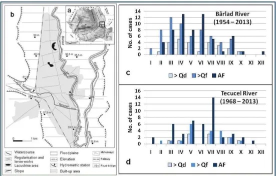
Study area. Tecuci City is located in the eastern part of Romania (Fig. 1a). Its administrative territory is crossed by 3 rivers (Fig. 1b): 1) Bârlad River, crossing the city area from North to South on a length of 11 km; 2) Tecucel River (Bârlad’s tributary), with a general direction from West to East, on a length of approx. 5 km, and 3) Rateş River, flowing in the eastern part of the city, approximately parallel to Bârlad River, with a length (in town area) of around 9 km (it is, in fact, a channel which regulates Bârlad River’s flow, through derivation).
Almost 1/3 of the total city’s area and 2/3 of the built are located within Bârlad’s floodplain, at an altitude of 26-40 m, with slopes smaller than 1 m/km. Although the annually amount of precipitation doesn’t exceed 500 mm (ranging between 60-70 mm/month in June-July, and less than 25 mm/month in January-March), the torrential summer rains can reach up to 70-80 mm in 24 hours (Zaharia et al., 2008 generating), engendering flash-floods.
Fig. 1. Study area location in Romania (a). Tecuci city area and the main engineering works (levees, Rateş channel) (b). Monthly frequency of floods occurred on the Bârlad River (c) and on Tecucel River (d) (Qd = danger discharge; Qf = flooding discharge;
AF = annual flood peak)
58
Data and methods. The study is mainly based on hydrologic data and data obtained from field investigations. The hydrologic data include average, maximum and minimum monthly and annual discharges recorded at 3 gauging stations located on the Bârlad, Tecucel and Rateş rivers, and hourly discharges of the 3 watercourses recorded during the September 2007 flash-flood. These data were provided by the “Romanian Waters” National Administration – Water Directorate Prut (RWNA – WDP). The field investigations were performed in many campaigns, between September 2007 and May 2014, which included observations and questioning of city residents. The main method was the statistical analysis of hydrologic data and survey answers.
3. RESULTS
3.1. The flood potential
59
maximum flow capacity of the channel is of 350 m3s-1. The highest discharge of 326 m3s-1 was reached on 6th September 2007 while the lowest discharge was 0.023 m3s-1, recorded on 6 January 1993 and 17 December 2009.
Due to the climatic conditions with aridity influences specific for the region and to its small size (L = 24 km; A = 112 km2), the Tecucel River has a very low multiannual discharge (0.146 m3s-1, during the 1968 – 2013 interval). It has a torrential regime, with rapid floods specific for the warm season, and very low discharges, reaching sometimes total depletion (during summer). Annual flood peaks have a large variability: between 1968 and 2013, they ranged from 0.230 m3s-1 (in 1994) to 183 m3s-1 (in 2007). The highest flood peaks were recorded in 1971 (122 m3s-1), 2005 (99.4 m3s-1), 2006 (98.8 m3s-1) and 2007 (183 m3s-1).
The number of floods with peak discharges higher than the discharge corresponding to the danger stage (40 m3s-1) was 11, while those higher than the discharge corresponding to the flooding stage (24 m3s-1) amounted to 20 in the period 1968 – 2013. The months with the highest frequency of floods with peak discharges exceeding the flooding threshold are May (6 cases), July and August (4 cases each). The annual floods occurred most frequently in July (14 cases), May (7 cases), March and June (6 cases each) (Fig. 1d).
The monthly frequency of the highest floods shows their predominant pluvial origin, an important role being played by summer heavy rains. As in the Bârlad River case, in some years many important floods (with discharges exceeding the danger threshold) occurred on the Tecucel River: in 2006 four such phenomena were recorded, and in 1971, 1972 and 2002 there were 2 floods each year.
3.2. The disastrous flood of September 2007 – a key point for flood risk management reappraisal
The most damaging flood affecting Tecuci City in the last half century occurred in September 2007. It originated from an exceptional rainfall event for this region occurred on September 5th, when, in the central part of Bârlad catchment and in the upper sector of Tecucel catchment, rainfall amounts exceeded 100 mm in 3 hours, and 200 mm in 24 hour (almost 40% of the region’s annual rainfall amount). As a result, a large flash-flood occurred on Tecucel River: in 6 hours (between 3:00 p.m. and 9:00 p.m. on September 5th), the discharge increased from 0.54 to 183 m3s-1. This was the highest discharge recorded on Tecucel River, since 1968 (when the gauging station was founded), with a return period of 500 years (Zaharia et al., 2008). Flash-floods occurred also on the other 2 rivers crossing the Tecuci City area: Bârlad’s discharge has grown in 20 hours from 1.40 m3s-1 to 245 m3s-1, and the one of the Rateş channel, through an important water volume of Bârlad River was derived, increased from 0.09 m3s-1 to 326 m3s-1 in 22 hours.
60
the Tecucel River’s flow was blocked at the entrance in Tecuci City by the undersized road and railway bridges and by the embankment-structure for railway elevating; the water overflowed these “barriers” and flowed through the city, heading towards the Bârlad River, and accumulated in a layer of over 2 m behind the levee along Bârlad’s right bank (Zaharia et al., 2009). The flooding affected approximately 70% of the built city area having disastrous consequences: 3 fatalities, 2210 houses were damaged (of which 392 were completely destroyed, and 425 suffered serious structural damage), and the city’s infrastructure was gravely deteriorated. The total cost of the damage amounted to approximately 6 million euro (according to the data from the Tecuci City Hall, the Galaţi County Inspectorate for Emergencies and the newspaper Evenimentul zilei no. 4983, from 12 September 2007). Other factors considered responsible for the amplification of the flood consequences were: the dysfunctions of the sewerage system; the inadequate engineering and maintenance of the Tecucel River channel; the low level of preparedness of the population with regard to the flood risk; the deficiencies in the flood risk management.
3.3. Measures for flood risk mitigation
Generally, the measures for flood risk mitigation are the consequence of disastrous events. The lessons learned from these events are starting point for understanding future flood risk and for improving the flood risk management (Chorynski et al., 2012). In the case of Tecuci City, as well as in Romania, in the last half century, the flood events which led to the development of new strategies and implementation of measures for flood risk mitigation occurred in the periods 1970 – 1975 and 2000 – 2007. Therefore, 2 major steps can be distinguished in flood risk management, related to the two mentioned periods.
3.3.1. Measures for flood risk mitigation before 2007
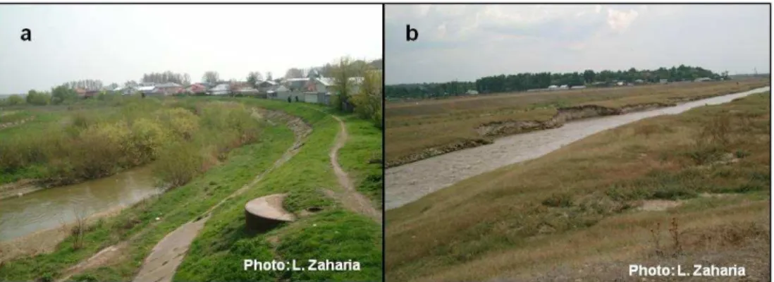
The measures to reduce flood risk in this period are mainly of structural type. In Tecuci City area, a particular attention has been paid to the protection against the floodings caused by the Bârlad River. Thus, the river was dammed and channelled; on both banks (Fig. 1b), earth protection levees were built, measuring 3 m in height and 4 m in width at the upper side (Fig. 2a). The dykes have 18.2 km in length on the right bank and 16.0 km on the left one (according to RWNA – WDP data). In 1980, the Rateş channel (Fig. 2b) was achieved as a supplementary protection measure against the floodings generated by the Bârlad River; the channel takes through derivation a part of the Bârlad River flow, especially during high waters. Although the levees have proved their efficiency in protecting Tecuci City against the overflowings of the Bârlad River, in September 2007 those on the right bank favoured the flooding of the city, as they acted like barriers for the Tecucel overflowing waters (Zaharia et al., 2008).
61
permanent reservoir was built at Buciumeni, in the upper course of the Tecucel River (with an area of 6 ha and a volume of 40,000 m3), but it was never functional. The scarce engineering on the Tecucel River, the presence of buildings very close to its banks, the thick vegetation and the waste deposited inside the riverchannel were factors that amplified the consequences of the September 2007 flood.
Fig. 2.Levee on the right bank of the Bârlad River (a). Rateş channel (b)
3.3.2. Measures for flood risk mitigation after 2007
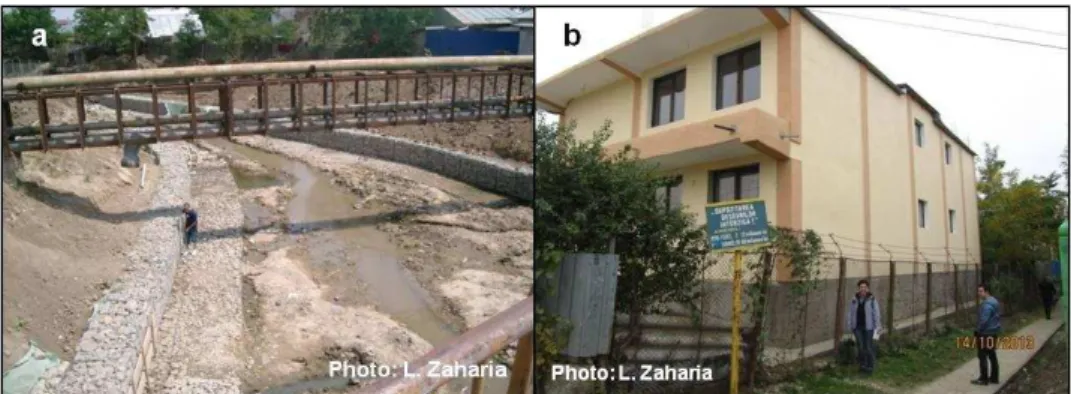
From disastrous flood that affected Tecuci City in September 2007, some lessons were derived: a small river (such as the Tecucel) may generate, in the context of favourable natural (flash-flood) and anthropogenic circumstances (the lack of appropriate defence works, inadequate maintenance, etc.), catastrophic damages; an important role in flooding genesis and increasing of its consequences can be played by the socioeconomic factors and transport infrastructure; the levees cannot always guarantee protection against flooding, but, in opposition, can become one of their causes, etc. (Zaharia et al., 2009, 2014). These lessons have led to new measures and actions, both structural and non-structural, aiming at flood risk mitigation in Tecuci City. Thus, since 2008, engineering and maintenance works were performed, mainly on Tecucel River: re-calibration, dredging works, bank protection and consolidation (Fig. 3a), riverbed vegetation and waste clearing, razing certain buildings-structures located very close to Tecucel River (which obstructed the river flow). On long term, two structural solutions are analysed: 1) a dam construction upstream from Tecuci city and 2) the diversion of the Tecucel River, so that it joint Bârlad River, downstream from Tecuci city. Although the construction of the dam would mean lower costs, the solution is less secure than the diversion of the Tecucel River (Zaharia et al., 2009).
62
Fig. 3. Engineering works on Tecucel River in August 2009 (a). New house adapted to flood risk (with an elevated foundation) (b)
In order to mitigate the flood risk in Tecuci City, after September 2007 flood event a greater attention was paid to the non-structural measures. In this regard, some improvements concerning the public information/education on flood risk can be revealed: in May 2014 (when 101 persons were interviewed), the rate of respondents considering they were insufficiently trained and informed about the flood risk, and expressing their desire to know more in this respect was 59%, while in August 2009 (when 163 persons were interviewed), the rate was 92% (Zaharia et al., 2014). This rising could be due partly to local actions for people information/education. Thus, in May 2013, the Tecuci City Hall completed the
Analysis and Risk Coverage Plan in Tecuci City (available online on the City Hall’s
website), which presents the potential risks locally identified (out of which flooding is representative), as well as the measures, actions and resources necessary for managing these risks (Tecuci City Hall, 2013).
A slight improvement after 2007 was also identified regarding the insurance policies: the rate of residents with life and asset insurances increased from 19% (in 2009) to 31% (in 2014).
For flood risk further mitigation other measures, mainly non-structural, should be considered also in flood risk management at local scale, as well as: the improvement of the warning system; the proper territorial planning taking into account the exposure to flood risk; the adequate maintenance and salubrization of river channels (especially the Tecucel one) and of the sewerage system; the raising of the number of life and assets insurance policies; improving the organisation and activities of institutions responsible for flood risk management (Stănescu and Drobot, 2002). In addition, engineering techniques allowing a faster drainage of the water which is blocked by levees should be envisaged, so as not to repeat the situation of September 2007.
4. CONCLUSIONS
63
took place in 1972, 1973, 2003, 2004 and especially in 2007. These events led to the implementation of measures for flood risk mitigation. If in the 1970s –1980s these measures were mainly of structural type, after 2007, a greater attention was paid to the non-structural measures. Although in the last years some improvements have been made in the field of flood risk management in Tecuci City, there are still measures that should be implemented for flood risk mitigation in this city, both structural and non-structural.
Acknowledgements
This work was performed under VULMIN Project (Contract no. 52/2012) financed by the Partnerships in Priority Areas Programme– Direction 3.
REFERENCES
1. Choryński, A., Pińskwar, I., Kron, W., Brakendridge, G.,R., Kundzewicz, Z.,W. (2012), Catalogue of large floods in Europe in the 20th century. In Kundzewicz Z.W. (ed.), Changes in Flood risk in Europe. IAHS Special Publication 10, CRC Press/Balkema, Taylor & Francis Group, 27-54.
2. National Institute of Statistics (NIS) (2013), Census of Population and Houses – 2011, http://www.rpl2011.djsct.ro/. accessed on January, 5, 2015.
3. Stănescu, V., Drobot, R. (2002), Măsuri nestructurale de gestiune a inundaţiilor. Edit. H.G.A., Bucureşti.
4. Tecuci City Hall (2013), Planul de Analiză şi Acoperire a Riscurilor din Municipiul
Tecuci. http://www.municipiultecuci.ro/doc/2014/ISU/Plan_aar_Tecuci_p1.pdf, accessed on
January, 6, 2015.
5. Zaharia, L., Ioana-Toroimac, G., Crăciun, E., Gogu, S. (2008), Impacts des événements climatiques extrêmes: les crues éclairs. Le cas de la rivière Tecucel (Roumanie). Actes du XXIème Colloque de l’AIC, Montpellier, France, 679-785. 6. Zaharia, L., Catană, S., Popa, D., Crăciun E., Crăciunescu, V. (2009), Synergetic
factors of the catastrophic flood affecting Tecuci City (Romania) in September 2007. Proceedings of Final conference of the COST action C22 Urban Flood Management in cooperation with UNESCO-IHP, Paris, France, 29-30.
7. Zaharia L., Ioana-Toroimac G., Dumitru-Ostachie L., Crăciun E. (2014), Lessons learned from disatruous floods: the case of Tecuci City (Romania). Proceedings of Danube Conference 2014 “Bridging the sciences – crossing borders”, Deggendorf (Germany), 207-210.