Lower Palaeozoic stratigraphy of the East Greenland
Caledonides
M. Paul Smith, Jan Audun Rasmussen, Steve Robertson, A.K. Higgins and A. Graham Leslie
The Lower Palaeozoic stratigraphy of the East Greenland Caledonides, from the fjord region of North-East Greenland northwards to Kronprins Christian Land, is reviewed and a number of new lithostratigraphical units are proposed. The Slottet Formation (new) is a Lower Cambrian quartzite unit, containing Skolithos burrows, that is present in the Målebjerg and Eleonore Sø tectonic windows, in the nunatak region of North-East Greenland. The unit is the source of common and often-reported glacial erratic boulders containing Skolithos that are distributed throughout the fjord region. The Målebjerg Formation (new) overlies the Slottet Formation in the tectonic windows, and comprises limestones and dolostones of assumed Cambrian–Ordo-vician age. The Lower Palaeozoic succession of the fjord region of East Greenland (dominantly limestones and dolostones) is formally placed in the Kong Oscar Fjord Group (new). Amend-ments are proposed for several existing units in the Kronprins Christian Land and Lambert Land areas, where they occur in autochthonous, parautochthonous and allochthonous settings.
Keywords: Early Palaeozoic, North-East Greenland, stratigraphy.
M.P.S., Lapworth Museum, School of Geography, Earth and Environmental Sciences, University of Birmingham, Edgbaston, Birmingham B15 2TT, UK. E-mail: m.p.smith@bham.ac.uk
J.A.R. & A.K.H., Geological Survey of Denmark and Greenland, Øster Voldgade 10, DK-1350 Copenhagen K, Denmark.
S.R. (deceased) & A.G.L., British Geological Survey, Murchison House, West Mains Road, Edinburgh EH9 3LA, UK.
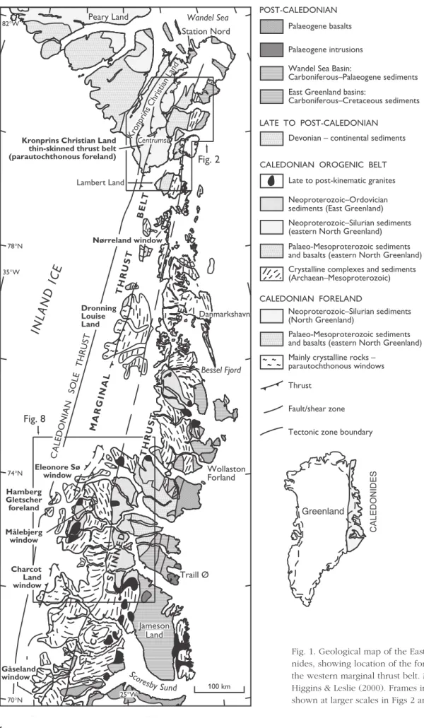
The East Greenland Caledonides extend for over 1300 km between Scoresby Sund (70°N) and Kronprins Christian Land (81°30′N), cropping out in an ice-free coastal strip of variable width (Fig. 1). In the south, the exposed width of the orogen is 300 km, but in the north this is reduced to less than 100 km. The orogen has been the subject of a series of systematic map-ping programmes by the Survey since 1968, supple-menting and revising work by other groups, most not-ably Lauge Koch’s long series of geological expedi-tions between 1926 and 1958 (see Haller 1971). This paper documents the key stratigraphical observations on Lower Palaeozoic rocks made during expeditions from 1993 to 1995 by the former Geological Survey of Greenland (GGU) to Kronprins Christian Land and Lambert Land (78°–82°N), and the 1997–1998 field
work by the Survey in the Kong Oscar Fjord region (72°–75°N). A number of new Lower Palaeozoic litho-stratigraphical units are proposed on the basis of this work and amendments are proposed for some exist-ing units.
▲ ▲ ▲ ▲ ▲ ▲ ▲ ▲ ▲ ▲ ▲ ▲ ▲ ▲ ▲ ▲ ▲ ▲ ▲ ▲ ▲ ▲ ▲ ▲ ▲ ▲ ▲ ▲ ▲ ▲ ▲ ▲ ▲ ▲ ▲ ▲ ▲ ▲ ▲ ▲ ▲ ▲ ▲ ▲ ▲ ▲ ▲ ▲ ▲ ▲ ▲ CALEDONIDES Greenland
70°N
74°N
78°N
82°W
35°W
Wandel Sea Centrumsø 100 km Jameson Land Sco resbySund
25°W
Traill Ø Wollaston Forland Bessel Fjord Danmarkshavn Lambert Land Peary Land Station Nord
Kronprins Christian Land
Nørreland window Kronprins Christian Land
thin-skinned thrust belt (parautochthonous foreland)
Palaeogene basalts
Palaeogene intrusions
Wandel Sea Basin:
Carboniferous–Palaeogene sediments
East Greenland basins:
Carboniferous–Cretaceous sediments
Devonian – continental sediments
Late to post-kinematic granites
Neoproterozoic–Ordovician sediments (East Greenland)
Neoproterozoic–Silurian sediments (eastern North Greenland)
Palaeo-Mesoproterozoic sediments and basalts (eastern North Greenland)
Crystalline complexes and sediments (Archaean–Mesoproterozoic)
Neoproterozoic–Silurian sediments (North Greenland)
Palaeo-Mesoproterozoic sediments and basalts (eastern North Greenland)
Mainly crystalline rocks – parautochthonous windows
Thrust
Fault/shear zone
Tectonic zone boundary POST-CALEDONIAN
LATE TO POST-CALEDONIAN
CALEDONIAN OROGENIC BELT
CALEDONIAN FORELAND
▲ ▲ Fig. 8 Fig. 2 CA LE DO NIA N SO LE TH RU ST
IN
L
A
N
D
IC
E
MARGINAL THR UST BEL T THICK SKINNED THR UST BEL T Gåseland window Charcot Land window Eleonore Sø window Målebjerg window Hamberg Gletscher foreland Dronning Louise Land ▲ ▲ ▲et al. 1991; Smith & Bjerreskov 1994) can, to a signifi-cant degree, be applied to the successions farther to the east and south within the study area (Figs 2, 3), although many of the units differ in detail. This re-gion is the only part of the Franklinian Basin to have been subsequently affected by the Caledonian oroge-ny, and the Lower Palaeozoic units described here occur both in the foreland and in the thin-skinned parautochthonous fold-and-thrust belt beneath the Vandredalen thrust sheet (Fig. 2; Higgins et al. 2001b). The Lower Palaeozoic successions of the fjord re-gion of the southern parts of North-East Greenland (72°–74°30′N; see Fig. 8) have been the subject of a more protracted research effort that extends back to the 19th century. The Cambrian–Ordovician of the fjord region has become one of the classic reference areas for this stratigraphical interval, but it was only during the 1997–1998 Survey field seasons that the tectonic context was fully elucidated (Higgins et al. 2004a). It is now clear that the Cambrian–Ordovician of the fjord region, together with the underlying, Neoproterozoic Tillite Group and Eleonore Bay Supergroup, make up the upper part of the highest thrust sheet in the orogen, which has been transported several hundred kilome-tres from the east-south-east (Higgins & Leslie 2000; Higgins et al. 2004a). Furthermore, notably different developments of Lower Palaeozoic rocks were dis-covered cropping out in tectonic windows adjacent to the Inland Ice; the successions within these windows are disturbed by Caledonian deformation, and are in-terpreted as autochthonous to parautochthonous rep-resentatives of the foreland (Smith & Robertson 1999a, b; Higgins et al. 2004a, b, this volume). The latter are fully documented for the first time here, and provide data critical for interpreting the Lower Palaeozoic evo-lution of the Iapetus passive margin and its subse-quent deformation during the Caledonian orogeny.
Kronprins Christian Land
The Lower Palaeozoic units cropping out over a c.
5000 km2 area in southern Kronprins Christian Land,
eastern North Greenland (Figs 2, 3), were mapped and documented in 1993–1995 as part of the 1:500 000 mapping programme carried out by GGU. Within the thin-skinned parautochthonous fold-and-thrust belt forming much of this region (Higgins et al. 2004b, this volume) exposure is often poor due to an exten-sive cover of recent glacio-fluvial sediments, and the best exposures are on the slopes of the main valleys,
with more scattered outcrops on the plateaus. The discontinuous exposure is disrupted by a series of eastward-dipping thrusts with displacements of sev-eral hundred metres to a few kilometres. Correlation of superficially similar Middle Ordovician to Silurian sediments in alternating units of peritidal dolostone and subtidal burrow-mottled limestones required de-tailed sedimentary facies analysis. Macrofaunal stratigraphy in the field was supplemented by the bio-stratigraphic analysis of conodonts, which in almost all cases verified the field determinations (Rasmussen & Smith 2001). Cambrian sediments are restricted to the sandstones of the Kap Holbæk Formation (see below), scattered representatives of which occur in autochthonous, parautochthonous and allochthonous settings.
Kap Holbæk Formation
revised
History. The Kap Holbæk Formation was first docu-mented by Adams & Cowie (1953) during a geologi-cal reconnaissance around the head of Danmark Fjord, and was informally divided into five members. Fränkl (1954) demonstrated that the unit was also present in Kronprins Christian Land around Sæfaxi Elv, and Hurst & McKerrow (1985) interpreted it as occurring within thrust sheets north of Romer Sø. Initial biostratigraph-ical determinations (Peel & Vidal 1988) concluded that, on the basis of acritarchs, the unit was of latest Vendian (late Ediacaran) age.
Clemmensen & Jepsen (1992) revised the Hagen Fjord Group of Haller (1961) to encompass a phase of Neoproterozoic shallow marine sedimentation which succeeds the Palaeoproterozoic–Mesoproterozoic In-dependence Fjord Group and the Mesoproterozoic Zig-Zag Dal Basalt Formation, and pre-dates Franklinian Basin sedimentation. Since the Kap Holbæk Forma-tion was thought to be of Vendian age, the formaForma-tion was considered to be representative of the youngest phase of sedimentation in the Hagen Fjord Group basin. However, two schemes of possible stratigraphic correlation could still be used to express the relation-ship of the Kap Holbæk Formation to the underlying Fyns Sø Formation, with radically different conse-quences in terms of basin evolution models and cor-relation with East Greenland.
▲ ▲ ▲ ▲ ▲ ▲ ▲ ▲ ▲ ▲ ▲ ▲ ▲ ▲ ▲ ▲ ▲ ▲ ▲ ▲ ▲ ▲ ▲ ▲ ▲ ▲ ▲ ▲ ▲ ▲ ▲ ▲ ▲ ▲ ▲ ▲ ▲ ▲ ▲ ▲ ▲ ▲ ▲ ▲ ▲ ▲ ▲ ▲ ▲ ▲ ▲ ▲ ▲ ▲ ▲ ▲ ▲ ▲ ▲ ▲ ▲ ▲ ▲ ▲ ▲ ▲ ▲ ▲ ▲ ▲ ▲ ▲ ▲ ▲ ▲ ▲ ▲ ▲ ▲ ▲ ▲ ▲ ▲ ▲ ▲ ▲ ▲ ▲ ▲ ▲ ▲ ▲ ▲ ▲ ▲ ▲ ▲ ▲ ▲ ▲ ▲ ▲ ▲ ▲ ▲ ▲ ▲ ▲ ▲ ▲ ▲ ▲ ▲ ▲ ▲ ▲ ▲ ▲ ▲ ▲ ▲ ▲ ▲ ▲ ▲ ▲ ▲ ▲ ▲ ▲ ▲ ▲ ▲ ▲ ▲ ▲ ▲ ▲ ▲ ▲ ▲ ▲ ▲ ▲ ▲ ▲ ▲ ▲ ▲ ▲ ▲ ▲ ▲ ▲ ▲ ▲ ▲ ▲ ▲ ▲ ▲ ▲ ▲ ▲ ▲ ▲ ▲ ▲ ▲ ▲ ▲ ▲ ▲ ▲ ▲ ▲ ▲ ▲ ▲ ▲ ▲ ▲ ▲ ▲ ▲ ▲ ▲ ▲ ▲ ▲ ▲ ▲ ▲ ▲ ▲ ▲ ▲ ▲ ▲ ▲ ▲ ▲ ▲ ▲ ▲ ▲ ▲ ▲ ▲ ▲ ▲ ▲ ▲ ▲ ▲ ▲ ▲ ▲ ▲ ▲ ▲ ▲ ▲ ▲ ▲ ▲ ▲ ▲ ▲ ▲ ▲ ▲ ▲ ▲ ▲ Rom erSø
I ngo
lf Fjord
Amdrup Land Holm Land Hovgaard Ø Kap Bernhoft Dijmphna Sund Hek la Sund Centru msø SK AL LIN GE N Sydv ejdal Rivie radal 20°W 80°N
81°N
Blåsø Skjoldung eelv Niogha lvfjerdsf jorden Græs elv Sæ fa xiE lv Da nm ark Fjo rd Van dre dal en thru st Vandr edalen Kap Holbæk PCMA Hj Lambert Land M FL H
Wandel Sea Basin sequence (post-Caledonian)
Samuelsen Høj Formation Lauge Koch Land Formation
Odins Fjord Formation
Turesø Formation
Wandel Valley Formation
Kap Holbæk Formation
Crystalline basement
Thrust
Fault Shear zone Børglum River and
Sjælland Fjelde Formations
Fyns Sø, Kap Bernhard, Campanuladal Fms
Hagen Fjord Gp Rivieradal Group
1. The late Ediacaran Kap Holbæk Formation could rest conformably on the Fyns Sø Formation, in which case the whole of the Hagen Fjord Group would probably be of Vendian age (Sønderholm & Jepsen 1991, fig. 18B).
2. The formation could rest disconformably on the Fyns Sø Formation; the latter could then be repre-sentative of the late Riphean to Sturtian carbonate developments that characterise the North Atlantic area. In this case, a substantial hiatus would span the Vendian, and the Hagen Fjord Group would be of Riphean to Sturtian age (Sønderholm & Jepsen 1991, fig. 18A).
The Kap Holbæk Formation overlies stromatolitic do-lostones of the Fyns Sø Formation at Kap Holbæk with a well-defined, but in detail obscured, contact. Clues that might have helped to differentiate between these two hypotheses include the occurrence of a sin-gle clast of Fyns Sø Formation-like lithology in the Morænesø Formation, a glacially influenced deposit of presumed Varanger age in central Peary Land (Collin-sonet al. 1989; Sønderholm & Jepsen 1991). An addi-tional indication was provided by Fränkl (1955) who had interpreted the Kap Holbæk Formation as being the fill of karstic cavities in the top of the Fyns Sø For-mation at a single locality in Sæfaxi Elv.
Field work in Sæfaxi Elv in 1994 confirmed and expanded on Fränkl’s observations. The uppermost part of the Fyns Sø Formation was found to contain cave systems, infilled with sandstone, which are of typical phreatic character (Smith et al. 1999). The Fyns Sø Formation is unconformably overlain by the Wan-del Valley Formation, which is sandy at the base but passes upwards into typical dolomitic lithofacies of the Danmark Fjord Member. Confirmation of the litho-stratigraphical relationships came from a locality at the junction of Hjørnegletscher and Ingolf Fjord; here
the Fyns Sø Formation is overlain by the Kap Holbæk Formation but infilled caves are preserved in the up-permost Fyns Sø Formation (Smith et al. 1999). Deep channels are incised into the top of the latter and both the caves and the channels are infilled by lithofacies that can be directly matched to the lower part of the Kap Holbæk Formation (Smith et al. 1999). The chan-nels and caves constitute one of the most spectacular and well-preserved examples of pre-Carboniferous palaeokarst recorded to date.
The demonstration of a hiatus between the Fyns Sø and Kap Holbæk Formations lends support to cor-relation alternative 2 above (scheme A of Sønderholm & Jepsen 1991), which invokes a major time gap be-tween the two units (Fig. 3). Further support comes from the interpretation of Bjørnøya (western Svalbard) as a detached North Greenland terrane (Smith 2000). On Bjørnøya, a carbonate unit similar to the Fyns Sø Formation is overlain by a sparse diamictite interpreted as a glacial horizon by Harland et al. (1993), indicat-ing that the carbonate is pre-Vendian. The glacial unit, the Sørhamna Formation, is unconformably overlain by the ‘Younger Dolomite’, a peritidal dolostone con-taining a mid-Early Ordovician fauna that is closely comparable with the Wandel Valley Formation (Smith 2000).
Efforts to internationally standardise the position of the Vendian–Cambrian boundary have produced a wealth of biostratigraphic data in recent years. The redefined boundary has the effect of including a con-siderable time interval, the Nemakit–Daldyn (544–535 Ma), within the Early Cambrian that was previously included within the Neoproterozoic. Furthermore, deepSkolithos burrows are now known to have a first appearance in the Tommotian (mid-Early Cambrian). Their presence close to the base of the Kap Holbæk Formation means that the unit is of Early Cambrian age, and is thus a probable correlative of the Buen Formation of North Greenland, as originally postu-lated (Peel 1980; Peel et al. 1981; see Fig. 7). Because of the substantial time gap between the Fyns Sø For-mation and the Kap Holbæk ForFor-mation, probably cor-responding to the whole of the Vendian, the younger unit is here removed from the Hagen Fjord Group.
Type section. Kap Holbæk, a headland close to the head of Danmark Fjord on its western side (Fig. 2).
Thickness. Estimates of the thickness of the Kap Hol-bæk Formation in the vicinity of Danmark Fjord range from 135 m (Adams & Cowie 1953) to 150 m
(Clem-Facing page:
mensen & Jepsen 1992). Farther to the east, in the inner part of Ingolf Fjord, the formation is 180 m thick but thins southwards, along the western flanks of the Prinsesse Caroline-Mathilde Alper, to zero around Sæfaxi Elv. At Sæfaxi Elv, the Ordovician Wandel Val-ley Formation rests unconformably on the Fyns Sø Formation and Kap Holbæk sediments are present only as the fill of palaeokarst cavities (Smith et al. 1999). The allochthonous Vandredalen thrust sheet does, however, contain the Kap Holbæk Formation (see below), indicating that the formation was present far-ther to the east prior to thrusting (Higgins et al. 2001b).
The thinning of the formation to zero is coincident with the position of the rift shoulder of the Hekla Sund basin, the name given by Fränkl (1955) to the half-graben rift basin in which the Neoproterozoic Rivieradal Group accumulated (see also Smith et al.
1999; Higgins et al. 2001b; Smith et al. 2004, this vol-ume), suggesting that the structure continued to exert an influence on sedimentation into the earliest Pal-aeozoic.
Boundaries. At the type locality, the Kap Holbæk For-mation disconformably overlies the Fyns Sø Forma-Silurian
Ordovician
Cambrian
Vendian
Sturtian
Riphean
Lauge Koch Land Formation Samuelsen Høj Formation Odins Fjord Formation Turesø Formation Børglum River Formation Sjælland Fjelde Formation Wandel Valley Formation
Kap Holbæk Formation
Hagen Fjord Group Fyns Sø Fm
Kap Bernhard Fm Campanuladal Fm Jyske Ås Fm
Zig-Zag Dal Basalt Formation
Independence Fjord Group
Hekla Sund Fm, Aage Berthelsen Gletscher Fm, & interbedded quartzites
thermal subsidence
extensional rifting and block tilting
extensional rifting Rivieradal Group
(allochthonous Vandredalen thrust sheet only)
post-rift thermal subsidence
Baltica collision thrust loaded
flysch basin
TECTONIC SETTING DEPOSITIONAL
ENVIRONMENT STRATIGRAPHY
lapetus passive margin
lapetus opening
pre-lapetus rift-sag
cycle
intracratonic extensional
events thermal subsidence
block tilting
ZZ
IF
HS/AB KH
RG
tion with a hiatus that probably corresponds to most of the Vendian. It is disconformably overlain by the Wandel Valley Formation, which is mid-Early Ordovi-cian in age at the base (Smith 1991; Smith & Bjerreskov 1994). These relationships pertain throughout the outcrop area, including the palaeokarst localities (Smith
et al. 1999).
Distribution. The Kap Holbæk Formation crops out around the southern end of Danmark Fjord, extend-ing southwards along the western side of Skjoldunge-elv to the Inland Ice (Fig. 2). Farther east, it crops out along the western side of Ingolf Fjord south of Hjørne-gletscher and along the western flanks of the Prinsesse Caroline-Mathilde Alper. At the junction of Hjørne-gletscher and Ingolf Fjord it additionally occurs infilling fossil caves in the Fyns Sø Formation, and this is the only context in which it occurs around Sæfaxi Elv. The formation is also present in the frontal part of the Vandredalen thrust sheet in Finderup Land, north of Romer Sø, where it was first described in the context
of the ‘Finderup Land Nappe’ (Hurst & McKerrow 1981a, b; Hurst et al. 1985).
Biota and age. Peel & Vidal (1988) noted a low diver-sity palynomorph assemblage from the formation and considered that the flora ‘in general suggests an age older than Cambrian’. However, as noted above, the base of the Cambrian has now been extended signifi-cantly downwards. The sandstones of the Kap Hol-bæk Formation also contain deep Skolithos burrows which extend vertically for many tens of centimetres (Clemmensen & Jepsen 1992, fig. 29) and occur to within 30 m of the base (Adams & Cowie 1953). The presence of deep Skolithos burrows indicates a Tom-motian (Early Cambrian) or younger age (Crimes 1992a).
S F WV
AB
Sæfaxi Elv
Ryder Gletscher Group
Wandel Valley Formation
Remarks. The development of the Wandel Valley For-mation in southern and eastern Kronprins Christian Land is very similar to that documented in the north-ern and westnorth-ern parts by Peel & Smith (1988). In the Sæfaxi Elv – Vandredalen area, the Danmarks Fjord Member (21 m) is overlain by 200 m of highly strained burrow-mottled lime mudstones (Amdrup Member) in which the burrows are considerably stretched. This unit is in turn overlain by 115 m of recessive dolosto-nes of peritidal origin (Alexandrine Bjerge Member). Extensive conodont sampling has verified this lithos-tratigraphic interpretation.
The three members of the Wandel Valley Forma-tion can be traced along the whole length of Sæfaxi Elv to a point opposite Harefjeld (Fig. 4), the type locality of the ‘Harefjeld Formation’ of Hurst (1984). The latter unit was considered to be a deep-water equivalent of the Lower Palaeozoic platform succes-sion that was present only in a single thrust sheet, the ‘Sæfaxi Elv nappe’, with a postulated displacement of over 100 km (Hurst & McKerrow 1981a, b, 1985; Hurst
et al. 1985). However, a number of sections examined around Harefjeld in 1994–1995 demonstrated an iden-tical succession to that in Sæfaxi Elv with sandy Danmarks Fjord Member overlying the Fyns Sø For-mation, and in turn overlain by burrow-mottled lime mudstones of the Amdrup Member. Harefjeld is cap-ped by poorly exposed, but distinctive, recessive buff dolostones assigned to the Alexandrine Bjerge Mem-ber (Fig. 4). The ‘thrust’ at the base of the ‘Sæfaxi Elv nappe’ of Hurst & McKerrow (1981a, b, 1985) was recognised to be an unconformity with associated palaeokarst development (Rasmussen & Smith 1996; Smithet al. 1999; see Kap Holbæk Formation above). The succession differs from that in the remainder of Kronprins Christian Land only in exhibiting particu-larly high levels of strain. Rasmussen & Smith (1996) therefore proposed the abandonment of the ‘Hare-fjeld Formation’.
The lower member of the Wandel Valley Forma-tion, the Danmarks Fjord Member, varies in thickness from 12 m around inner Danmark Fjord (Smith & Peel 1986) to 20–21 m at Marmorvigen and the inner parts of Ingolf Fjord. The upper part of the unit is strongly brecciated by evaporitic collapse at Ingolf Fjord and Marmorvigen (up to 10 m in thickness), whereas a 2.5 m thick breccia occurs in the middle part of the member on the east side of inner Danmark Fjord.
East of Vandredalen, the Danmarks Fjord Member is overlain by highly strained burrow-mottled lime mudstones (200 m) in which the burrows are consid-erably stretched (Fig. 5). These have yielded cono-donts of late Early Ordovician age and are assigned to the Amdrup Member of the Wandel Valley Forma-tion. This member is in turn overlain by recessive dolostones of peritidal origin (115 m) containing Whiterockian (Middle Ordovician) conodonts, together indicative of the Alexandrine Bjerge Member (Fig. 4). In summary, all three members of the Wandel Valley Formation in the Sæfaxi Elv – Harefjeld – Ingolf Fjord area are very similar to their development in the Danmark Fjord area on the foreland. Intervals with shallower water lithofacies in the southernmost
rep-A
B
resentatives of the formation in western Lambert Land (see section on Lambert Land below) suggest that a southern or eastern margin of the platform is being approached.
Sjælland Fjelde Formation
Remarks. The Sjælland Fjelde Formation in the type section near Danmark Fjord is around 100 m thick and comprises a lower dark grey, burrow-mottled dolo-stone/limestone unit and an upper, grey dolostone unit (Ineson et al. 1986). The thickness and character of the formation are maintained in the eastern and southern parts of Kronprins Christian Land. East of Vandredalen, the Vandredalen thrust follows a long flat in the upper Alexandrine Bjerge Member before ramping up westwards to a flat in the upper dolo-stone unit of the Sjælland Fjelde Formation. The for-mation has been traced northwards along strike from Sæfaxi Elv as far as the western side of Hjørneglet-scher, a distance of around 70 km, and the Vandreda-len thrust maintains both the same topographic level and the same stratigraphic level within the Sjælland Fjelde Formation.
The southernmost exposure of the Sjælland Fjelde Formation is close to the Inland Ice, 30 km west of Centrumsø. The Alexandrine Bjerge Member is there overlain by 36 m of highly fossiliferous limestones that
may be equivalent to the ‘Opikina Limestone’ of
Scrutton (1975). The remainder of the interval beneath the Børglum River Formation is covered, but the likely overall thickness of the Sjælland Fjelde Formation at this locality is around 110 m.
Morris Bugt Group
Børglum River Formation
Remarks. The Børglum River Formation comprises lithologically monotonous, burrow-mottled lime mud-stones and wackemud-stones. The formation is generally highly fossiliferous in the upper part with abundant stromatoporoids, corals, gastropods and cephalopods together with rarer brachiopods and trilobites. A dis-tinctive 10 m thick dolostone horizon occurs 20 m below the top of the formation and constitutes a use-ful marker horizon in sections where the overlying Turesø Formation is intensely deformed.
Substantial areas of Børglum River Formation were mapped in 1995, and the formation remains uniform throughout the mapping area. It is difficult to provide an accurate estimate of the thickness since, owing to tectonics and exposure, no sections were found in which both the upper and lower boundaries were exposed. The value of 430 m estimated by Smith et al.
(1989) seems, however, to be a reasonably valid one.
Turesø Formation
Remarks. Previous to the 1993–1995 mapping pro-gramme, the Turesø Formation was known to show a marked increase in thickness from around 150 m in Peary Land to over 200 m in northern Kronprins Chris-tian Land (Peel 1985). This trend is maintained south-wards, and a section measured 5 km west of Cen-trumsø (Fig. 6) had a thickness of 320 m in which subtidal burrow-mottled intervals of lime mud- and wackestone are more dominant than farther to the west in Peary Land. This produces a distinctive black and white striped appearance which is of consider-able utility in identifying the formation from a dis-tance.
The uppermost Ordovician(?) – lowermost Silurian succession in the western part of Vandredalen shows a slightly different development to the area west of Centrumsø. The tectonically deformed succession, in a major footwall ramp of the Vandredalen thrust, com-prises a lower dolostone unit, a middle burrow-mot-tled unit and an upper dolostone unit. The lower unit is a minimum of 20 m thick (the base is unexposed) and comprises alternating dolostone beds and bur-row-mottled limestones. It is succeeded by about 90 m of burrow-mottled limestones containing a diverse macrofauna, which includes brachiopods, tabulate corals, cephalopods and stromatoporoids. The 130 m thick upper dolostone member is made up of white-weathering dolostone beds and interbedded dark grey limestones that give the unit a distinctive, striped ap-pearance. The upper dolostone unit is generally poor in macrofossils, but does contain sparse stromatopo-roids and brachiopods.
prob-able that the Ordovician–Silurian boundary occurs well below this level.
Washington Land Group
Odins Fjord Formation
Remarks. Although the Odins Fjord Formation is widely exposed across the area, it is rather uniformly developed, and was examined in detail only at its most southerly occurrence west of Blåsø. The mini-mum thickness in this part of southern Kronprins Christian Land is 220 m. This compares with a thick-ness of 200 m in southern Peary Land, which increases northwards to around 300 m approaching the shelf margin in central Peary Land (Hurst 1984).
The transition from the Turesø Formation to the Odins Fjord Formation at Blåsø is marked by a change in weathering colour from pale grey to pale brown. At the same level, the lithology alters from dolostone-dominated to limestones rich in tabulate corals and stromatoporoids. The lower 100 m are dominated by brown-weathering, burrow-mottled limestones, some of which are floatstones.
A very distinctive pale dolostone interval occurs 70–103 m above the base, and contains abundant cal-cite-cemented vugs, probably representing
pseudo-morphed evaporitic nodules. The pale weathering, dark grey limestones are notably bituminous. This interval is at approximately the same level within the Odins Fjord Formation as the peritidal sediments of the Melville Land Member in Peary Land (Hurst 1984) and it is likely that they are broadly correlative. The interval was not initially recognised in the Centrumsø area, but a much thinner development at around 100 m above the base may be the correlative. As with the Wandel Valley Formation, the presence of intervals with shallower water lithofacies in southernmost Kronprins Christian Land suggests that a southern or eastern margin of the platform is being approached.
Samuelsen Høj Formation
Remarks. Although reefs of the Samuelsen Høj For-mation had previously been documented on the north-ern side of Centrumsø (Fränkl 1954; Hurst 1984), they had not previously been recognised farther to the south. However, in 1994–1995 a single small reef was located within a thrust sheet that extends southwards from the western end of Centrumsø for around 10 km along the eastern side of Græselv. The small reef di-rectly overlies stromatoporoidal biostrome facies of the Odins Fjord Formation. The reef, approximately 50 m in diameter and 20 m high, is typical of the
mation, with a massive, unbedded core facies and radially dipping flank beds.
Peary Land Group
Lauge Koch Land Formation
Remarks. The southernmost occurrence of the Lauge Koch Land Formation in Kronprins Christian Land is in the parautochthonous fold-and-thrust belt immedi-ately to the south of Centrumsø. In contrast to the typical development of the Samuelsen Høj Formation reef in this area, that of the overlying flysch is atypi-cal. Hurst & Surlyk (1982) assigned all of the Silurian flysch in Kronprins Christian Land to the ‘Profilfjeldet Shales’ of Fränkl (1954), and the unit was given mem-ber rank within the Lauge Koch Land Formation. In the type section on the west side of Vandredalen, the lower part of the Profilfjeldet Member is dominated by quartz conglomerates and sandstone turbidites. Locally, black mudstones with rare starved ripples and thin-bedded muddy siltstones are developed up to a thickness of a few metres.
In distinct contrast, the lower part of the section south of Centrumsø contains approximately 50 m of black siltstones and sandstones with interbedded car-bonates overlying the Odins Fjord Formation and the Samuelsen Høj Formation reef. The black siltstones and fine- to medium-grained sandstone beds are 5– 30 cm thick and contain planar lamination. In places a rhythmic alternation of 1 cm sandstone with 1–3 cm shaly siltstone can be seen. The interbedded carbon-ates are very dark grey to black, bituminous, nodular and burrow-mottled with calcite concretions; there are abundant black silty partings. The abundant macro-fauna includes graptolites, cephalopods and gastro-pods. The interbedding of turbiditic clastic sediments with burrow-mottled carbonates is somewhat unusual, but presumably represents intermittent distal turbidite deposition in a deep subtidal setting which, during times of low clastic influx, allowed the re-establish-ment of carbonate deposition and a burrowing infauna. Above the lower black shale/carbonate unit, the Lauge Koch Land Formation is more typically devel-oped. A 25 m thick interval of green-weathering, very thinly bedded, shaly siltstones and sandstones is over-lain by cliff-forming sandstone turbidites. The latter contain Ta–c,e and Tb–e units and 4 m thick, massive channel fills are present. Coarsening- and thickening-upward 20–30 m cycles are also present. The
thrust-truncated thickness is approximately 150 m, well within the maximum thickness of 400 m cited for the member (Hurst & Surlyk 1982).
Lambert Land
Prior to the 1993–1995 mapping programme, the Wan-del Valley Formation was not known to crop out south of Kronprins Christian Land. Escher & Jones (1994), however, pointed to the possible presence of Early Palaeozoic carbonates in westernmost Lambert Land, North-East Greenland (Fig. 2), resting unconformably upon Independence Fjord Group quartzites.
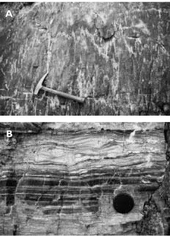
Examination of the quartzite-carbonate boundary near the Inland Ice margin in westernmost Lambert Land demonstrated that the carbonates unconform-ably overlie Independence Fjord Group quartzites, with a very slight angular discordance. The basal 25 m of the carbonates constitute a generally pale weathering unit, which is made up of current laminated dolosto-nes with scours and some ripple lamination, together with darker wavy laminated dolostones containing ripples and drapes (Fig. 5B). Some cyclicity is evident, and the top of one cycle contains probable pseudo-morphed evaporite nodules. This lower unit is over-lain by highly strained, dark-weathering wavy lami-nated and burrow-mottled carbonates, dolomitised to greater or lesser degrees. The current laminated dolo-stones are absent above 25 m.
Taking into account the lithofacies present, the unconformable relationship with the Independence Fjord Group, and the recovery of fragmentary cono-donts, the Lambert Land carbonates are assigned to the Wandel Valley Formation. It is probable that the lower 25 m unit represents the Danmarks Fjord Mem-ber and that the overlying carbonates are part of the Amdrup Member. The thickness of the upper unit in Lambert Land is difficult to estimate due to structural complications, but it does not exceed the 200 m seen in the Amdrup Member in Kronprins Christian Land.
over-step, and perhaps indicates that maximum pre-Wan-del Valley Formation uplift was farther to the south than hitherto anticipated. The depositional environ-ments are broadly comparable with the development to the north, but the burrow-mottled upper unit in Lambert Land seems to be of slightly shallower water origin than the Amdrup Member, suggesting proxim-ity to a southern and/or eastern margin to the Franklinian platform in Lambert Land.
Dronning Louise Land
The extensive nunatak region of Dronning Louise Land (Fig. 1) was first documented geologically during the 1952–1954 British North Greenland expedition (Pea-cock 1956, 1958). The region was not re-investigated in detail until the systematic mapping programme con-ducted by GGU in 1989–1990 (Friderichsen et al. 1990; Holdsworth & Strachan 1991; Strachan et al. 1994). Dronning Louise Land is divided by a N–S-trending imbricate zone into an autochthonous foreland area
to the west, and parautochthonous to allochthonous Palaeoproterozoic gneiss complexes with interbanded metasedimentary rocks to the east, transported west-wards as thrust sheets. The foreland area comprises crystalline basement orthogneisses overlain by se-quences of sedimentary rocks assigned to the ‘Trekant’ and ‘Zebra series’. The older ‘Trekant series’ and un-derlying basement gneisses are intruded by dolerite dykes, and are overlain unconformably by the ‘Zebra series’. The ‘Zebra series’ is also present in the imbri-cate zone where it overlies pale grey-green sandstones that are intruded by metadolerites.
200 km
Morris Bugt Group
Ryder Gletscher
Group
Brønlund Fjord Group
TIG
M
KH
Hagen Fjord Group
Independence Fjord Group
Buen Formation PLF/KCM
WSW ESE NW ESE N S
Wandel Valley Formation
RG FS
Portfjeld Formation
Crystalline basement
Daugaard-Jensen
Land
Peary Land
Lamber
t
Land
Kronprins Christian
Land
M
M L
L
V
endian
Riph.
Stur
.
Pr
oter
ozoic
Cambrian
Or
do
v.
U
Fig. 7. Proterozoic – Middle Ordovi-cian stratigraphic relationships on the platform area of North and North-East Greenland, showing the extent and magnitude of the sub-Wandel Valley unconformity. Maximum uplift and associated erosion was in Lambert Land, at the extreme right hand side of the diagram. The locations of Daugaard-Jensen Land and Peary Land are indicated on the inset map of Greenland in Fig. 2. FS, Fyns Sø Formation (Hagen Fjord Group); KH, Kap Holbæk Formation; M, glacial sediments of the Morænesø Forma-tion;PLF/KCM, quartz arenite sandstone sheet assigned to the Permin Land Formation and the Kap Coppinger Member; RG, Rivieradal Group (see Smith et al. 2004, this volume);TIG, Tavsens Iskappe Group. Modified from Smith (2000).
Facing page:
▲ ▲ ▲ ▲ ▲ ▲ ▲ ▲ ▲ ▲ ▲ ▲ ▲ ▲ ▲ ▲ ▲ ▲ ▲ ▲ ▲ ▲ ▲ ▲ ▲ ▲ ▲ ▲ ▲ ▲ ▲ ▲ ▲ ▲ ▲ ▲ ▲ ▲ ▲ ▲ ▲ ▲ ▲ ▲ ▲ ▲ ▲ ▲ ▲ ▲ ▲ ▲ ▲ ▲ ▲ ▲ ▲ ▲ ▲ ▲ ▲ ▲ ▲ ▲ ▲ ▲ ▲ ▲ ▲ ▲ I I I I I I I I I I I I I I I I I I I I I I I I I I I I I I I I I ▲ ▲ ▲ ▲ ▲ ■ ■ ■ ■ ■ ■ ■ ■ ■ ■ ■ ■ ■ ■ ■ ■ ■ ■ ■ ■ ■ ■ ■ ■ ■ ■ ■ Eleonore Sø window Hamberg Gletscher foreland Målebjerg window Charcot Land window Nathorst Land Hudson Land Ella Ø Suess Land Andrée Land Lyell Land Stauning Alper
Kong O sca
r Fjord
KFJF AEL ES S ML M G Cecilia Nunatak HB ON Neoproterozoic–Ordovician
Post-Caledonian Caledonian granite 930 Ma granite
Palaeoproterozoic–Ordovician Krummedal sequence Krummedal sequence Palaeoproterozoic orthogneiss Archaean–Palaeoproterozoic orthogneiss ▲ ▲ ▲ ▲
Franz Joseph allochthon
Foreland
Hagar Bjerg thrust sheet
Niggli Spids thrust sheet
In the foreland of north-west Dronning Louise Land, the ‘Zebra series’ comprises 3–10 m of basal pebble conglomerates, overlain by 10–15 m of purple-white striped quartzites. These pass upwards into yellow-white medium- to coarse-grained quartzites (5–30 m) and interbanded magnetite sandstones, siltstones and mudstones (10 m; Friderichsen et al. 1990). These clas-tic rocks are overlain by around 10 m of fine-grained grey-black limestones. Deep Skolithos burrows are found in situ in the quartzites demonstrating, as with the Kap Holbæk Formation, that the ‘Zebra series’ is no older than Cambrian. The quartzites are thus cor-relative with the Kap Holbæk Formation of Kronprins Christian Land, the Slottet Formation of the Eleonore Sø and Målebjerg windows (see below), and the Kløftelv Formation (Kong Oscar Fjord Group – see below) of the Franz Joseph allochthon.
A similar succession is present within the ‘Zebra series’ of the imbricate thrust zone where, in central Dronning Louise Land, Friderichsen et al. (1990) re-corded 2 m of pale green sandstones with thin lensoid pebble beds up to 20 cm thick at the base, overlain by 45 m of white to rusty weathering medium-grai-ned quartzites with abundant tabular cross-bedding. These beds are overlain by a heterogeneous 50 m package of interbedded grey-green siltstone, dark mudstone, thin quartzites, yellow sandstones and lime-stones. The base of this latter unit contains ichnofossils assigned to Cruziana sp. (Strachan et al. 1994), which indicate a maximum age of Atdabanian (mid-Early Cambrian; Crimes 1992b). The quartzites are overlain by about 120 m of grey dolomitic limestones – a strati-graphic signature that is very similar to the succes-sions in the Eleonore Sø and Målebjerg windows (see below). The precise age of the dolomitic limestones at the top of the ‘Zebra series’ in both the foreland and imbricate zone is uncertain, but they must be of Cambrian–Ordovician age.
Nunatak region 71°50
′′′′′
N–74°30
′′′′′
N
The presence of in situ Lower Palaeozoic sediments in the western nunatak region of the southern part of the East Greenland Caledonides (Fig. 8) had not been demonstrated prior to the 1997–1998 Survey mapping programme. However, several clues had been noted, namely the presence of erratic carbonate blocks con-taining Early Ordovician conodonts on Cecilia Nunatak (72°30′N; J.S. Peel in Higgins et al. 1981), and the abundant occurrence of quartz arenite blocks
contain-ing Skolithos throughout the Caledonides (see e.g. Haller 1971, fig. 48). Two tectonic windows through thrust sheets (Leslie & Higgins 1998, 1999) discovered in 1997 revealed the presence of Vendian tillites, Cambrian sandstones and Cambrian–Ordovician car-bonates in the footwall immediately underlying the bordering thrusts; these distinctive successions record the effects of Caledonian deformation, and have been interpreted as representing autochthonous to
parau-tochthonous Caledonian foreland (Higgins et al.
2001a). While the strain levels in these units are high, sufficient sedimentary detail can be observed to al-low confident interpretation and correlation.
Slottet Formation
new formation
History. The ‘Slottet Quartzite’ was first described by Katz (1952) from the Eleonore Sø region (74°N), and was included within a group of rocks that was corre-lated with the upper part of what is now the Nathorst Land Group (lower Eleonore Bay Supergroup). Sub-sequently, Haller (1971), following a suggestion of Wenk (1961), assigned the quartz-arenite unit to his ‘Basal Series’ of the Eleonore Bay Supergroup. This complex of rocks included a wide variety of litholo-gies, and it is now clear that a wide range of ages is also represented (Leslie & Higgins 1998, 1999). As part of the systematic re-mapping programme of 1997–1998, the Eleonore Sø region was revisited, and it was rec-ognised that the rock units were located within a major
Facing page:
window through a Caledonian thrust sheet. When the effects of Caledonian deformation were restored, it became clear that Haller’s (1971) supposed ‘Basal Se-ries’ in this region is a complex of volcanic and sedi-mentary rocks deposited in a rift setting and uncon-formably overlain by the Slottet Formation (Leslie & Higgins 1998). The older group of rocks was infor-mally termed the ‘Eleonore Sø complex’, while the discovery of Skolithos burrows in the younger ‘Slottet quartzite’ indicated the Cambrian age of the unit (Leslie & Higgins 1998; Smith & Robertson 1999b).
Further outcrops of the ‘Slottet quartzite’ were lo-cated 70 km east of the Eleonore Sø region at the foot of Målebjerg, in another smaller tectonic window through a Caledonian thrust, now known as the Måle-bjerg window. These outcrops were originally mapped by Haller (1953), and their resemblance to the ‘Slottet quartzite’ was pointed out by Haller (1971) who also placed them in his ‘Basal Series’ of the Eleonore Bay Supergroup.
Name. The formation is named after the promontory
of Slottet (‘the castle’) to the south of Eleonore Sø, where the unit crops out spectacularly and was first described by Katz (1952).
Type section. The north side of the ice-dammed lake in Gemmedal, north of Målebjerg (Fig. 9A).
Thickness. At the type section, the formation is 143 m thick (Fig. 10). In the vicinity of Slottet, photogram-metric calculations suggest that the unit is consider-ably thicker, of the order of 350 m (see photograph on front cover of this volume) although this is much less than the > 1000 m estimate derived from Katz’s observations that was quoted by Haller (1971).
Lithology. In the type section north of Målebjerg (Figs 9A, 10), the lower 10 m comprise structureless or pla-nar laminated, fine- to coarse-grained quartz arenites in 10–30 cm beds. From 10–36 m, the maximum grain size diminishes, and fine- to medium-grained sand-stones occur in 0.2–1.6 m beds. The quartz arenites are parallel laminated and cross-bedded, the latter sometimes being of very large scale, with sets up to 1.6 m. Some beds are lenticular at outcrop scale, and shaly interbeds are sometimes present. Above 36 m, the fine-grained quartz arenites are in beds of 0.3– 1.5 m thickness, and are either structureless or cross-bedded with sets up to 1 m and very low angle foresets. The beds are mainly tabular, but some are seen to
Fig. 10. Composite log of the Slottet and Målebjerg Formations at the type locality in the Målebjerg window. The lenticular clastic succession beneath the Slottet Formation, with two diamictite levels, occupies a depression in the gneissic base-ment, and is interpreted as a Vendian tillite.
Camb.-Ord.
Cambrian
Vendian Tillite
Pre-Vendian Basement
vf f m c vc
Clay Silt Sand granule pebble cobble boulder Age Unit Lithology Structure
Målebjerg F.
Slottet Formation
m 200
150
100
50
0
thrust
? ?
Gneiss
Sandstone
Mudstone-siltstone
Limestone Dolostone
Large scale cross-bedding
Ripple-lamination
Skolithos Burrow-mottling
Scours
Planar lamination
Igneous or metamorphic clast
Sedimentary clast
wedge out at outcrop scale. Interbeds of thin sand-stones and sandy shales up to 0.4 m thick occur. Cur-rent directions determined from foreset orientation are predominantly towards the south-east.
At 79 m, there is a conspicuous change from golden brown-weathering quartz arenites to a rusty weather-ing alternation of interbedded quartz arenites and sandy shales. This unit is 50 m thick (79–129 m) although above 112 m the mud content falls off. The quartz arenites are in beds of < 15–60 cm and are largely structureless, although hints of cross-bedding do oc-cur. The sandy shales comprise mudstones (now slaty) with lenticular sand bodies up to a few centimetres thick and traces of ripple lamination. In some places, mud drapes were observed on foreset laminae. The formation is capped by a 14 m thick massive quartz arenite that is structureless and virtually unbedded.
Boundaries. North of Målebjerg, in the type section on the north side of the ice-dammed lake in Gemmedal (Fig. 8), the Slottet Formation lies unconformably on gneisses of probable Palaeoproterozoic age. However, a few hundred metres farther north the gneisses are overlain by a lenticular tillite unit with a maximum thickness of 31 m (Figs 9A, 10). The unit contains two beds of diamictite separated and overlain by platy quartzites, phyllites and semi-pelites. This unit can be seen to gradually wedge out southwards, and occu-pies a hollow on a peneplaned surface of basement gneisses. The lower part of the lower diamictite bed (1.4 m) comprises clast-supported pebbles and cob-bles resting on sheared granitic gneiss, but within 30 cm there is a gradation up into matrix-supported diamictites. The matrix is composed of fine sand which in places is micaceous and phyllitic. The upper diamictite bed is up to 7.6 m thick, but thickens and thins markedly along strike. The clasts are dominated by fine- to coarse-grained granitic lithologies but also include metasandstones and carbonates, with the lat-ter up to 6 × 1.5 × 1 m in size. The unit is considered to be of Varanger age and is disconformably overlain by the Slottet Formation.
Distribution. The Slottet Formation occurs around the margins of the Eleonore Sø and Målebjerg tectonic windows. Within the Eleonore Sø window, the for-mation is present in J.L. Mowinckel Land, Arnold Escher Land and around Eleonore Sø itself, and in the Målebjerg area it crops out on either side of the N–S-trending glacier that bisects the window.
Fauna and age. The Slottet Quartzite is characterised by the presence of Skolithos burrows that attain lengths of several tens of centimetres (Fig. 9B). The first un-equivocal appearance in the type section is at the base of the rusty weathering unit (79 m), but more equivo-cal examples are present as low as 45 m. As noted in the discussion of the Kap Holbæk Formation, the pres-ence of deep Skolithos indicates an age for the unit that is no older than Tommotian (mid-Early Cambrian).
Målebjerg Formation
new formation
History. Katz (1952) recognised and mapped a car-bonate unit above his ‘Slottet quartzite’ in the eastern Eleonore Sø region, but considered it to represent mylonitised Eleonore Bay Supergroup. In the 1997– 1998 field seasons it was recognised that the carbon-ate unit, although highly strained, conformably over-lies the Slottet Formation and over-lies in the footwall of the thrust that bounds the Eleonore Sø and Målebjerg windows (Leslie & Higgins 1998; Smith & Robertson 1999b).
Name. Named after the mountain Målebjerg, which
lies immediately to the south of the type section.
Type section. The type section of the Målebjerg For-mation is a continuation of the Slottet ForFor-mation type section, on the northern side of the ice-dammed lake in Gemmedal, north of Målebjerg (Fig. 10). A better exposed, but less accessible, reference section is pre-sent on a nunatak (73°41′N, 28°40′W) south of J.L. Mowinckel Land, within the Eleonore Sø window.
Thickness. In the type section (Fig. 10), 32 m of sedi-ment are preserved beneath the thrust that terminates the section. In the reference section, the formation is 45 m thick, and a similar thickness is present wher-ever it crops out within the Eleonore Sø window.
with buff dolomite burrow fills. In places these can be seen to be shallowing-upward, subtidal burrow-mottled limestone – peritidal dolostone cycles similar to those that commonly occur elsewhere in the Laurentian Cambrian–Ordovician.
In the reference section in J.L. Mowinckel Land, the basal sandy dolostones become progressively less sandy upwards; parallel lamination and ripple lami-nation with dolomitic mud drapes are present. This unit is overlain by 3.5 m of dolostones in which 2–3 cm beds of fine-grained dolostone alternate with 0.5 cm beds of coarser, sand-grade, dolomite. The latter are parallel laminated and low amplitude ripples are also developed. From 5–20 m, massive buff-weather-ing pale grey dolostones occur in beds up to 2.5 m thick. For the most part these beds are structureless but traces of burrow-mottling are present in places, as are fenestral, laminated dolostones and current lami-nation. More thinly bedded dolostones make up the interval from 20–40 m; these are predominantly struc-tureless or current laminated, and extensively veined with quartz and carbonate. The uppermost 5 m com-prise dark, burrow-mottled limestones with buff bur-row fills that become increasingly strained and myloni-tised towards the thrust that terminates the section.
Boundaries. In both sections, the basal sandy dolo-stones overlie the Slottet Formation with no angular discordance and the succession is truncated by the thrust that bounds the tectonic windows.
Distribution. As with the Slottet Formation, the car-bonate unit is restricted to the margins of the Eleonore Sø and Målebjerg windows. However, because it is markedly thinner and less resistant to weathering it crops out less frequently.
Fauna and age. There is, to date, no fauna recorded from the Målebjerg Formation, although its tectonic context and the presence of bioturbation in the form of burrow-mottling, together with its conformable boundary with the underlying Slottet Formation, sug-gest a Cambrian–Ordovician age.
Fjord region 71°36
′′′′′
–74°17
′′′′′
N
The presence of Cambrian–Ordovician sediments within the outer fjord region of North-East Greenland (71°36′–74°17′N; Fig. 8) has been known since the
early work of Lauge Koch and Christian Poulsen. Their good exposure and relative ease of access has resulted in more research than areas to the north (for reviews see Cowie & Adams 1957; Henriksen & Higgins 1976; Smith & Bjerreskov 1994; Stouge et al. 2001). The tec-tonic setting has, however, remained rather more en-igmatic since, although clearly incorporated within the Caledonian orogen, the units are relatively undeform-ed. Mapping of the underlying Eleonore Bay Super-group in 1997–1998 has clarified this relationship, and it is now apparent that the Lower Palaeozoic rocks of the fjord region are part of the highest level thrust sheet in this sector of the orogen, and have been trans-ported several hundreds of kilometres from the east-south-east (Smith & Robertson 1999a, b; Higgins & Leslie 2000; Higgins et al. 2004a) before involvement in syn- to post-orogenic collapse (Hartz & Andresen 1995; Andresen et al. 1998).
The Cambrian–Ordovician formations are here in-corporated within the newly erected Kong Oscar Fjord Group (Fig. 11).
Kong Oscar Fjord Group
new groupSwett & Smit 1972). Extensive logging and sample collecting for conodont work was carried out by P. Frykman in 1977, and by M.P. Smith and J.S. Peel in 1988. This has resulted inter alia in a refinement of biostratigraphical constraints, particularly in the Late Cambrian – Ordovician part of the group (Smith 1985, 1991; Smith & Bjerreskov 1994; Huselbee 1998). Ad-ditional field work has been carried out in the succes-sion by Stouge et al. (2001, 2002), and documenta-tion of Early Cambrian small shelly faunas was under-taken, with subsequent biostratigraphic refinements, by Skovsted (2003).
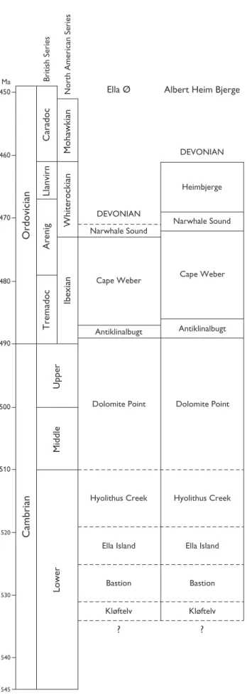
Name. Named after Kong Oscar Fjord, at the head of which lies the island of Ella Ø with the most easily accessible and most studied outcrops of the group (Fig. 12A).
Type area. In view of the above, the most suitable type area is Ella Ø. Important reference areas, which contain the only complete sections through the two youngest formations, are present in the north of the outcrop belt at Albert Heim Bjerge and C.H. Ostenfeld Nunatak (Fig. 8; Cowie & Adams 1957; Frykman 1979; Hambrey et al. 1989; Smith 1991; Smith & Bjerreskov 1994; Stouge et al. 2002).
Thickness. On Ella Ø, the group is 2625 m thick (Cowie & Adams 1957; Smith & Bjerreskov 1994) including a revised thickness of 1161 m for the Cape Weber For-mation (Smith 1991). The upper part of the group thick-ens northwards (and perhaps also eastwards), and Frykman (1979) recorded an apparently unfaulted thickness of 1750 m for the Cape Weber Formation on C.H. Ostenfeld Nunatak. In addition, Frykman (1979) estimated a thickness of 1200 m for the Heimbjerge Formation on C.H. Ostenfeld Nunatak, rather than the maximum 320 m recorded beneath Devonian red beds on Albert Heim Bjerge (Cowie & Adams 1957). The Kong Oscar Fjord Group in the northernmost part of
450
460
470
480
490
500
510
520
530
540
545 Ma
Cape Weber Cape Weber
Narwhale Sound
Narwhale Sound Heimbjerge Albert Heim Bjerge
DEVONIAN
Antiklinalbugt Antiklinalbugt
Dolomite Point Dolomite Point
Hyolithus Creek
Cambrian
Ordovician
Caradoc
British Series
Mohawkian
North American Series
Whiterockian
Ibexian
Arenig
Tremadoc
Upper
Middle
Lower
Llanvirn
Ella Island
Bastion
Kløftelv
Hyolithus Creek
Ella Island
Bastion
Kløftelv
? ?
DEVONIAN Ella Ø
the outcrop belt is thus likely to be around 4500 m thick, its maximum within the region.
Dominant lithology. The lower part of the group (Kløftelv Formation and Bastion Formation) is domi-nated by quartz arenites that fine upwards into glauconitic sandstones, and sandy micaceous and fer-ruginous shales. Clastic supply wanes in the upper Bastion Formation, and the remainder of the group is carbonate-dominated. The Ella Island Formation is limestone-dominated, but the succeeding two units, the Hyolithus Creek Formation and Dolomite Point Formation, are dolostone-dominated.
The Ordovician units comprise an alternation of thick, pale grey, homogeneous subtidal limestones (Cape Weber Formation and Heimbjerge Formation), with more thinly bedded units in which subtidal or subtidal–peritidal shallowing-upwards sequences are developed on the scale of 1–5 m (Antiklinalbugt For-mation and Narwhale Sound ForFor-mation). Significant developments of thrombolitic–stromatolitic reefs are present in the basal part of the Antiklinalbugt Forma-tion on Ella Ø (Fig. 12C) and the lower 100 m of the Cape Weber Formation on Albert Heim Bjerge and C.H. Ostenfeld Nunatak (Hambrey et al. 1989; Stouge
et al. 2001).
Boundaries. The Kong Oscar Fjord Group overlies the Tillite Group. At outcrop scale, the boundary appears to be sharp but conformable. However, northwards along strike the uppermost unit of the Tillite Group, the Spiral Creek Formation (maximum thickness 55 m) wedges out and the Kløftelv Formation rests on the underlying Canyon Formation (Fig. 12B; Hambrey & Spencer 1987; Hambrey et al. 1989). It is thus
prob-able that a regional hiatus and/or low angle uncon-formity is present at the base of the Kløftelv Forma-tion.
Stougeet al. (2001, 2002) inferred the presence of a significant disconformity or condensed interval at the Antiklinalbugt Formation – Cape Weber Forma-tion boundary. The Antilklinalbugt FormaForma-tion contains early Ibexian macro- and microfaunas, and a cepha-lopod identified as ?Cyptendoceras sp. indet. recov-ered from the basal beds of the Cape Weber Forma-tion was considered to be of late Ibexian age. Togeth-er with the absence of a middle Ibexian macrofauna, this evidence was used to invoke the presence of a disconformity or condensed interval spanning the middle Ibexian. However, closely spaced conodont samples throughout the interval from the upper Dolo-mite Creek Formation to the top of the Cape Weber Formation (Smith 1985, 1991; Huselbee 1998) dem-onstrate that there is a complete succession, and that there is no significant disconformity or condensed interval present.
The upper part of the group is cut by the Caledo-nian erosion surface, and is overlain by DevoCaledo-nian molasse of the Kap Kolthoff Group. On Ella Ø, the erosion level is within the middle part of the Narwhale Sound Formation, and on Albert Heim Bjerge it cuts through the lower part of the Heimbjerge Formation, whereas on C.H. Ostenfeld Nunatak a much thicker section in the latter unit is preserved. Complete sec-tions through the Narwhale Sound Formation and the overlying Heimbjerge Formation are thus present only in the northern part of the outcrop belt.
Distribution. The group is present in a narrow belt
that extends from Canning Land (71°36′N) through
the fjord region to C.H. Ostenfeld Nunatak (74°17′N), and is confined to the Franz Joseph allochthon. The main outcrop forms part of the Neoproterozoic–Or-dovician division shown in Fig. 8; the detached out-crops on Canning Land lie 90 km east-south-east of the south-east corner of Fig. 8.
Geological age. Early Cambrian – Upper Whiterockian (Middle Ordovician – upper Llanvirn sensu Fortey et al.1995).
Subdivision. The Kong Oscar Fjord Group contains nine formations: Kløftelv Formation, Bastion tion, Ella Island Formation, Hyolithus Creek Forma-tion, Dolomite Point FormaForma-tion, Antiklinalbugt mation, Cape Weber Formation, Narwhale Sound
For-Facing page:
mation and the Heimbjerge Formation (Fig. 11). The Cambrian–Ordovician boundary occurs within the uppermost part of the Dolomite Point Formation (Miller & Kurtz 1979; Huselbee 1998).
The Lower Palaeozoic units of the East Greenland foreland, observed in the parautochthonous setting of the Eleonore Sø and Målebjerg tectonic windows (Slottet Formation and Målebjerg Formation formally erected above), are specifically excluded from the group because of the significantly different deposi-tional context, located high on the craton in an at-tenuated Neoproterozoic – Lower Palaeozoic succes-sion.
Acknowledgements
We are grateful to the referees, J.S. Peel and J.E. Repet-ski, whose perceptive comments greatly improved the manuscript.
References
Adams, P.J. & Cowie, J.W. 1953: A geological reconnaissance of the region around the inner part of Danmarks Fjord, North-east Greenland. Meddelelser om Grønland 111(7), 24 pp. Andresen, A., Hartz, E. & Vold, J. 1998: A late orogenic extensional
origin for the infrastructural gneiss domes of the East Green-land Caledonides (72º–74ºN). Tectonophysics 285, 353–369. Clemmensen, L.B. & Jepsen, H.F. 1992: Lithostratigraphy and geological setting of Upper Proterozoic shoreline-shelf depo-sits, Hagen Fjord Group, eastern North Greenland. Rapport Grønlands Geologiske Undersøgelse 157, 27 pp.
Collinson, J.D., Bevins, R.E. & Clemmensen, L.B. 1989: Post-gla-cial mass flow and associated deposits preserved in palaeo-valleys: the Late Precambrian Morænesø Formation, North Greenland. Meddelelser om Grønland Geoscience 21, 26 pp. Cooper, R.A. 1999: The Ordovician time scale – calibration of graptolite and conodont zones. Acta Universitas Carolinae – Geologica43(1/2), 1–4.
Cowie, J.W. & Adams, P.J. 1957: The geology of the Cambro-Ordovician rocks of East Greenland. 1. Meddelelser om Grønland153(1), 193 pp.
Crimes, T.P. 1992a: The record of trace fossils across the Protero-zoic–Cambrian boundary. In: Lipps, J.H. & Signor, P.W. (eds): Origin and early evolution of the Metazoa, 177–202. New York: Plenum Press.
Crimes, T.P. 1992b: Changes in the trace fossil biota across the Precambrian–Phanerozoic boundary. Journal of the Geologi-cal Society (London) 149, 637–646.
Encarnación, J., Rowell, A.J. & Grunow, A.M. 1999: A U-Pb age for the Cambrian Taylor Formation, Antarctica: implications for the Cambrian timescale. Journal of Geology 107, 497– 504.
Escher, J.C. & Jones, K.A. 1994: Caledonian thrusting and shear-ing in Lambert Land. In: Henriksen, N. (ed.): Express report: eastern North Greenland and North-East Greenland 1994, 27– 38. Unpublished report, Geological Survey of Greenland, Copenhagen.
Fortey, R.A., Harper, D.A.T., Ingham, J.K., Owen, A.W. & Rushton, A.W.A. 1995: A revision of the Ordovician series and stages from the historical type area. Geological Magazine 132, 15– 30.
Fränkl, E. 1954: Vorläufige Mitteilung über die Geologie von Kron-prins Christian Land (NE-Grönland). Meddelelser om Grønland 116(2), 85 pp.
Fränkl, E. 1955: Weitere Beiträge zur Geologie von Kronprins Christian Land (NE-Grönland). Meddelelser om Grønland 103(7), 35 pp.
Friderichsen, J.D., Holdsworth, R.E., Jepsen, H.F. & Strachan, R.A. 1990: Caledonian and pre-Caledonian geology of Dronning Louise Land, North-East Greenland. Rapport Grønlands Geo-logiske Undersøgelse 148, 133–141.
Frykman, P. 1979: Cambro-Ordovician rocks of C.H. Ostenfeld Nunatak, northern East Greenland. In: Peel, J.S. (compiler): Lower Palaeozoic stratigraphy and palaeontology: shorter contributions. Rapport Grønlands Geologiske Undersøgelse 91, 125–132.
Haller, J. 1953: Geologie und Petrographie von West-Andrées Land und Ost-Frænkels Land (NE-Grönland). Meddelelser om Grønland73 I (3), 174 pp.
Haller, J. 1961: The Carolinides: an orogenic belt of late Precam-brian age in Northeast Greenland. In: Raasch, G.O. (ed.): Geology of the Arctic 1, 155–159. Toronto University Press. Haller, J. 1971: Geology of the East Greenland Caledonides, 413
pp. London: Interscience.
Hambrey, M.J. & Spencer, A.M. 1987: Late Precambrian glacia-tion of central East Greenland. Meddelelser om Grønland Geoscience19, 50 pp.
Hambrey, M.J., Peel, J.S. & Smith, M.P. 1989: Upper Proterozoic and Lower Palaeozoic strata in northern East Greenland. Rap-port Grønlands Geologiske Undersøgelse 145, 103–108. Harland, W.B., Hambrey, M.J. & Waddams, P. 1993: The Vendian
geology of Svalbard. Norsk Polarinstitut Skrifter 193, 150 pp. Hartz, E. & Andresen, A. 1995: Caledonian sole thrust of central East Greenland: a crustal scale Devonian extensional detach-ment. Geology 23, 637–640.
Henriksen, N. & Higgins, A.K. 1976: East Greenland Caledonides. In: Escher, A. & Watt, W.S. (eds): Geology of Greenland, 182– 246. Copenhagen: Geological Survey of Greenland. Higgins, A.K. & Leslie, A.G. 2000: Restoring thrusting in the East
Greenland Caledonides. Geology 28, 1019–1022.
Higgins, A.K., Friderichsen, J.D. & Thyrsted, T. 1981: Precam-brian metamorphic complexes in the East Greenland Caledo-nides (72°–74°N) – their relationships to the Eleonore Bay Group and Caledonian orogenesis. Rapport Grønlands Geo-logiske Undersøgelse104, 5–46.
Higgins, A.K., Leslie, A.G. & Smith, M.P. 2001a: Neoproterozoic – Lower Palaeozoic stratigraphical relationships in the marginal thin-skinned thrust belt of the East Greenland Caledonides: comparisons with the foreland in Scotland. Geological Maga-zine 138, 143–160.
Higgins, A.K., Smith, M.P., Soper, N.J., Leslie, A.G., Rasmussen, J.A. & Sønderholm, M. 2001b: Caledonian inversion of the Hekla Sund Basin, eastern North Greenland: a pre-Iapetan rift sequence displaced across its rift shoulders during the Caledonian orogeny. Journal of the Geological Society (Lon-don)158, 487–499.
Higgins, A.K. et al. 2004a: The foreland-propagating thrust archi-tecture of the East Greenland Caledonides 72°–75°N. Journal of the Geological Society (London) 161, 1009–1026. Higgins, A.K., Soper, N.J., Smith, M.P. & Rasmussen, J.A. 2004b:
The Caledonian thin-skinned thrust belt of Kronprins Chris-tian Land, eastern North Greenland. In: Higgins, A.K. & Kals-beek, F. (eds): East Greenland Caledonides: stratigraphy, struc-ture and geochronology. Geological Survey of Denmark and Greenland Bulletin 6, 41–56 (this volume).
Holdsworth, R.E. & Strachan, R.A. 1991: Interlinked system of ductile strike slip and thrusting formed by Caledonian sinis-tral transpression in northeastern Greenland. Geology 19, 510– 513.
Hurst, J.M. 1984: Upper Ordovician and Silurian carbonate shelf stratigraphy, facies and evolution, eastern North Greenland. Bulletin Grønlands Geologiske Undersøgelse 148, 73 pp. Hurst, J.M. & McKerrow, W.S. 1981a: The Caledonian nappes of
eastern North Greenland. Nature 290, 772–774.
Hurst, J.M. & McKerrow, W.S. 1981b: The Caledonian nappes of Kronprins Christian Land, eastern North Greenland. Rapport Grønlands Geologiske Undersøgelse 106, 15–19.
Hurst, J.M. & McKerrow, W.S. 1985: Origin of the Caledonian nappes of eastern North Greenland. In: Gee, D.G. & Sturt, B.A. (eds): The Caledonide Orogen – Scandinavia and related areas, 1065–1069. London: John Wiley & Sons.
Hurst, J.M. & Surlyk, F. 1982: Stratigraphy of the Silurian turbidite sequence of North Greenland. Bulletin Grønlands Geologiske Undersøgelse145, 121 pp.
Hurst, J.M., Jepsen, H.F., Kalsbeek, F., McKerrow, W.S. & Peel, J.S. 1985: The geology of the northern extremity of the East Greenland Caledonides. In: Gee, D.G. & Sturt, B.A. (eds): The Caledonide Orogen – Scandinavia and related areas, 1047– 1063. London: John Wiley & Sons.
Huselbee, M.Y. 1998: Late Cambrian to earliest Ordovician (Ibexian) conodont evolution and biogeography of Green-land and northwest ScotGreen-land, 296 pp. Unpublished Ph.D. the-sis, University of Birmingham, UK.
Ineson, J.R., Peel, J.S. & Smith, M.P. 1986: The Sjælland Fjelde Formation: a new Ordovician formation from eastern North Greenland. In: Peel, J.S. (ed.): North Greenland Lower Pal-aeozoic palaeontology and stratigraphy: short contributions. Rapport Grønlands Geologiske Undersøgelse 132, 27–37. Katz, H.R. 1952: Ein Querschnitt durch die Nunatakzone
Ost-grönlands (ca. 74° n.B.). Ergebnisse einer Reise vom Inland-eis (in Zusammenarbeit mit den Expéditions Polaires Françaises von P.-E. Victor) ostwärts bis in die Fjordregion, ausgeführt im Sommer 1951. Meddelelser om Grønland 144(8), 65 pp.
Leslie, A.G. & Higgins, A.K. 1998: On the Caledonian geology of Andrée Land, Eleonore Sø and adjacent nunataks (73º30′– 74ºN), East Greenland. In: Higgins, A.K. & Frederiksen, K.S. (eds): Caledonian geology of East Greenland 72°–74°N: pre-liminary reports from the 1997 expedition. Danmarks og Grøn-lands Geologiske Undersøgelse Rapport 1998/28, 11–27. Leslie, A.G. & Higgins, A.K. 1999: On the Caledonian (and
Grenvillian) geology of Bartholin Land, Ole Rømer Land and adjacent nunataks, East Greenland. In: Higgins, A.K. & Frede-riksen, K.S. (eds): Geology of East Greenland 72°–75°N, mainly Caledonian: preliminary reports from the 1998 expedition. Danmarks og Grønlands Geologiske Undersøgelse Rapport 1999/19, 11–26.
Miller, J.F. & Kurtz, V.E. 1979: Reasssigment of the Dolomite Point Formation of East Greenland from the Middle Cambrian(?) to the Lower Ordovician based on conodonts. Geological Soci-ety of America Abstracts with Programs 10, 219 only. Nathorst, A.G. 1901: Bidrag til nordöstra Grönlands geologi.
Geologiska Föreningens i Stockholm Förhandlingar 23, 275– 306.
Peacock, J.D. 1956: The geology of Dronning Louise Land, N.E. Greenland. Meddelelser om Grønland 137(7), 38 pp. Peacock, J.D. 1958: Some investigations into the geology and
petrography of Dronning Louise Land, N.E. Greenland. Med-delelser om Grønland 157(4), 139 pp.
Peel, J.S. 1980: Geological reconnaissance in the Caledonian fore-land of eastern North Greenfore-land, with comments on the Cen-trum Limestone. Rapport Grønlands Geologiske Undersøgel-se99, 61–72.
Peel, J.S. 1985: Cambrian–Silurian platform stratigraphy of east-ern North Greenland. In: Gee, D.G. & Sturt, B.A. (eds): The Caledonide Orogen – Scandinavia and related areas, 1077– 1094. London: John Wiley & Sons.
Peel, J.S. & Smith, M.P. 1988: The Wandel Valley Formation (Early– Middle Ordovician) of North Greenland and its correlatives. In: Peel, J.S. (ed.): Cambrian–Jurassic fossils, trace fossils and stratigraphy from Greenland. Rapport Grønlands Geologiske Undersøgelse137, 61–92.
Peel, J.S. & Vidal, G. 1988: Acritarchs from the Kap Holbæk For-mation, North Greenland. In: Peel, J.S. (ed.): Cambrian–Juras-sic fossils, trace fossils and stratigraphy from Greenland. Rap-port Grønlands Geologiske Undersøgelse 137, 42 only. Peel, J.S., Ineson, J.R., Lane, P.D. & Armstrong, H.A. 1981: Lower
Palaeozoic stratigraphy around Danmark Fjord, eastern North Greenland. Rapport Grønlands Geologiske Undersøgelse 106, 21–27.
Pickerill, R.K. & Peel, J.S. 1990: Trace fossils from the Lower Cambrian Bastion Formation of North-East Greenland. In: Peel, J.S. (ed.): Lower Cambrian trace fossils from Greenland. Rap-port Grønlands Geologiske Undersøgelse 147, 5–43. Rasmussen, J.A. & Smith, M.P. 1996: Lower Palaeozoic
carbon-ates in eastern North Greenland, and the demise of the ‘Sæfaxi Elv nappe’. Bulletin Grønlands Geologiske Undersøgelse 172, 49–54.