João Cunha Borges /
Teresa Marat-Mendes
When Lisbon met the Team 10
Cluster City
Instituto Universitário de Lisboa (ISCTE-IUL) DINÂMIA’CET-IUL, Lisboa, Portugal Instituto Universitário de Lisboa (ISCTE-IUL) DINÂMIA’CET-IUL, Lisboa, PortugalPA
P
E
R
S
1. Introduction
This essay explores relations between the Cluster City, developed by Team 10 in the 1950s, and the urbanization of the Chelas Valley in Lisbon, under the ‘Plano de Urbanização de Chelas’ (PUC) designed in the 1960s, by architects Francisco Silva Dias and José Rafael Botelho, with João Reis Machado, Alfredo Silva Gomes, Luís Vassalo Rosa and Carlos Worm. Although the PUC strongly resonates with Cluster City principles, such relationship is not straightforward.
Starting with the context and definition of cluster, we highlight the conceptual roots of the PUC. As Zone I was the first Chelas zone to be designed and built, we focus in it, disclosing the principles underlying its original plan, i.e., its ‘ground rules’, and changes verified until the present. For ‘ground rules’ we mean rules governing physical elements of urban form, including grids, streets, squares, blocks, lots, buildings and façades (Marat-Mendes, 2002).
We highlight the principles of these plans and the urban forms used to implement them, and how these can be approached towards neighbourhood redevelopment and sustainability, which place great pressures on urban housing.
2. Team 10 and post-WW2 urbanism
Although CIAM (Congrés Internacionaux d’Architecture Moderne) provided influent guidelines for modernist urbanism, post-WW2 broke its ideals of rationality and universalism. Downplaying local and ecological conditions, the functional city, synthesized in the
Chartre d’Athénes, provided the ideal background for capitalism and
placelessness (Montaner, 2012).
At the preparatory meeting for CIAM IX, in Sigtuna, 1952, urbanism was approached from the ‘Habitat’ perspective rather than the Charte
d’Athénes (Borges, 2017). But only at the IX Congress, in
Aix-en-Provence 1953, a number of young architects advanced their sceptic perspective over modernist planning. These included Alison and Peter Smithson, Jaap Bakema, Aldo Van Eyck, Shadrach Woods and Georges Candilis, who founded Team 10 (1953–1981), the group charged with organizing the next CIAM congress.
Two projects presented in Aix may be highlighted:
1) The unbuilt project for the Golden Lane Estate (1952) by the Smithsons, introducing a novel urban form, comprising concrete slabs spreading through elevated open-air decks or streets-in-the-air (popularly known as streets-in-the-sky) and were meant to recreate the sociability of prewar London streets (Smithson and Smithson, 1967);
2) The Carriéres Centrales in Casablanca (1951), by GAMMA (Groupe des Architectes Modernes Maroquins), which included Candilis and Woods, using deck-accesses in a structure inspired by Moroccan bidonvilles. Both designs significantly draw from already existing and inhabited places.
Frontispiece and Fig.1 Toulouse-Le Mirail land-use scheme (Ferreira, 1969)
PA
P
E
R
Team 10 urban principles were advanced by the Doorn Manifesto, written in 1954 as guidelines for CIAM 10. In eight points, the Manifesto calls for architects to design solutions for connections in urban space, the particularity of architectonic design to its placement, relations between built and community structures and the importance of precedents (Smithson and Smithson, 2005).
The Doorn Manifesto and its ‘Habitat’ notion react to CIAM
rationalism, prioritizing the phenomenological aspect of cities and their integration in wider cultural patterns (Borges, 2017). Moreover, with intense urban population-growth, CIAM architects requested it would turn into a Charter of Habitat, to guide interventions in cities while facing the limits of the so called ‘modern movement’ (Soltan, 1959). Although this Charter was never materialized, the humanistic tone of the Doorn
Manifesto was attuned with critical approaches to modernity of its time.
2.2. Any coming together is cluster
In line with the Doorn Manifesto, the Smithsons introduced the ‘cluster’ notion at CIAM 10 — “a specific pattern of association (…) to replace such group concepts as ‘house, street, district, city’ (community sub-division) or ‘isolate, village, town, city’ (group entities) which are too loaded with historical overtones” (Smithson and Smithson, 1967, p. 33). In 1957 they elaborate further: “a close knit, complicated, often moving aggregation (…) with a distinct structure (…) for creat[ing] the signs and images which represent the functions, aspirations and beliefs of the community (…) in such a way they add up to a comprehensible whole” (Smithson and Smithson, 1957, pp. 334–336).
The 1951 CIAM discussion on the ‘core’ of the city eventually extended to other city parts and their specific conditions: through local and adaptive structures, the cluster dismantles previous urban concepts, including the Charte d’Athénes functional division, technocratically similar to the production system (Borges, 2017). Instead of zoning, the cluster proposes mixed-use site-specific urban forms designed to grow and change without losing identity.
The cluster notion retroactively enlightens the use of patios in low-rise and high-rise housing in the Carriéres Centrales, or Van Eyck’s sequences of patterned modules and voids in the Amsterdam Orphanage (1955–61), or the Smithsons’ linking of sparse buildings through streets-in-the-sky in Golden Lane, their first directly stated attempt at turning the cluster into an urban model — the Cluster City. In it, urban forms and patterns of association were integrated across different scales — from individual houses to mass-housings, from close-distance walkways to motorways.
“Any coming together is cluster”, the Smithsons (1967, p. 33) said. In a sense, it is a methodological, even epistemological tool for planning, where recognizable patterns of space and aggregation are key. These ideas matured into several urban projects — built and
unbuilt — throughout the next decade. In 1961, the Smithsons present
PA
P
E
R
their Hamburg Steilshoop proposal (Smithson and Smithson, 2005), a town extension, never implemented, seeking correspondences between different types of housing and of mobility structures. In an integral system, a high-speed road leads to high-density crescents; main distributor-roads to deck-access flats and low-speed loop-roads to individual housing. The former two are also linked by streets-in-the-sky while the latter includes a system of pedestrian walkways. Equipment includes market-places, parking and schools, and a centre with green areas.
The following year, Candilis-Josic-Woods start the plan for the Toulouse-Le Mirail town extension (Figure 1), implemented until 1973 (Candilis et al, 1975). Here, pedestrian and car circulation were segregated, and zoning was replaced by a linear pedestrian ‘stem’ with commerce and services, determining the location of housing slabs. There is a further green strip, workshops and industrial facilities in the outskirts. Housing density decreases from the centre to the periphery, predominantly linked by walkways and topographically adapted.
3. The GTH and the Portuguese 1960s
In the 1960s, Portugal is ruled by the New State (1933–1974), a
conservative dictatorship. Council housing programmes had translated mostly to low-density Garden City-inspired neighbourhoods, but were insufficient for Lisbon’s housing demand, leading to the emergence of slums (Teixeira, 1992).
1960s Portuguese architecture is marked by the ‘Inquérito à Arquitectura Popular Portuguesa’ (1961), a survey of vernacular construction which discloses strategic precedents for modern
architectural form (Marat-Mendes and Cabrita, 2016). Fernando Távora’s Quinta da Conceição Pavilion (1958–1960) and Álvaro Siza’s Boa Nova Tea House (1958–1963) show how the ‘Inquérito’ incited a Portuguese streamline of regional modernism. Interestingly, conceptualizing the relation of contemporary architecture with the past was among the themes of the never-finished Charter of Habitat.
Also important is the participation of Viana de Lima, Távora and Octávio Lixa Filgueiras in CIAM X, at Dubrovnik 1956, under the direction of Team 10. This group of Portuguese architects presents a project for a rural housing estate informed by the ‘Inquérito’, problematizing relations between old vs. new architecture, individual vs. community, house vs. common areas (Marat-Mendes and Cabrita, 2016), contributing to the revision of modernism promoted by Team 10.
Yet innovation on large-scale planning is more surprising in the Lisbon GTH, a municipal department which replaces in 1961 the Gabinete de Estudos Urbanísticos (GEU) and is charged with designing State-financed neighbourhoods.
At this time, Lisbon urban planning is chaotic. The Lisbon Masterplan (1938–1948) by Étienne de Gröer, although municipally approved was rejected by the State. A new plan, acknowledging its predecessor, is
PA
P
E
R
prepared by the GEU in 1959, but also fails to get approval. Lisbon suburbs are witnessing an explosion of illegal construction, especially at municipal borderlines, as in Brandoa (Amadora), later considered one of Europe’s largest shanty-towns (Castela, 2011).
Against this background, the GTH, comprising architects, urbanists, engineers and sociologists, is tasked with urbanizing the Eastern end of Lisbon in three plans: Olivais Norte (1955–1958), Olivais Sul (1955–1960) and Chelas (1960–1964). The recent experience of the Alvalade Plan (1945), mostly formed by four-storey blocks in semiautonomous cells, would be radicalized.
The plans for Olivais Norte and Sul assume the Chartre d’Athénes as a model for high-density (Gonçalves et al, 2016), partly justified by pressures from the construction industry and the continued existence of slums in Lisbon. The International Union of Architects (UIA) Congress, taking place in Lisbon in 1953, privileged debates on architectural tradition and modernity, also favoured a planning paradigm change. Despite their collectivist aspects, GTH plans are approved and implemented, probably because authorities had little understanding of their encapsultated social values (Dias, 2019).
3.1. The Chelas Valley
In 1960, José Rafael Botelho, one of the planners of Olivais Sul, joins Francisco Silva Dias and João Reis Machado to plan the urbanization of another agrarian area, the Chelas Valley. The plan underwent three stages: the Basis PUC, the Definitive PUC and the subsequent plans for specific zones.
On the Basis PUC, housing and green areas mutually determine each other, and motorways do not coincide with land-use borderlines. Within cells, built and unbuilt areas cluster. The ‘ground rules’ of the Basis PUC are: centripetal cellular structuring; city integration through strategic motorways; regional integration through motorways and train; creating services and green parks; high-density construction and topographical adaptation (GTH, 1965).
Later the Basis PUC is redesigned under coordination by Silva Dias, leading to the Definitive PUC in 1964: linear distribution of equipment in ramified urban-life strips; association of activities instead of zoning; and linked but detached motorways and walkways (GTH, 1965). In strips of intense urban-life, there are specific ‘ground rules’: high-density housing; commerce along pedestrian walkways; equipment for culture; points for nightlife; and services to provide links to the city (GTH, 1965).
The PUC, may be the Portuguese urbanization closest to the Cluster City model. During its preparation, Candilis-Josic-Woods plan Toulouse-Le Mirail, while the Smithsons design Hambourg Steilshoop and the Economist Cluster (1959–1964). Linear public spaces, confirmed in Zones I and J, resemble the ‘stem’ by Candilis-Josic-Woods, while the extensive use of streets-in-the-sky and semi-public areas in Zones I, J
and N2 shows an interpretation of the Smithsons’ mass-housing ideas.
PA
P
E
R
3.2. Zone I
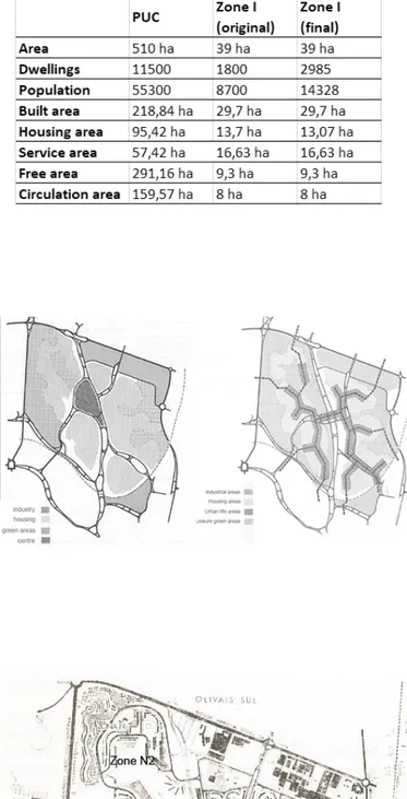
In 1966, Silva Dias and Vassalo Rosa finish the Zone I plan, the Northeast end of the Chelas Valley, crossed by the Olivais – Areeiro Road, added only in the 1990s (Heitor, 2001). This is to house 8700 people in 1800 houses (Dias et al, 1966), but grows to 2985 houses upon conclusion (Heitor, 2001). Eight residential types for four rent-categories are designed (Table 1).
The Zone I ‘ground rules’ are: linear pedestrian strip for
community-life elements in a pedestrian strip where housing slabs are also placed; memorability of landscape through dynamic or cinematic design; framing of views; public spaces for all seasons; sequences of squares from the limits to the centre; confrontation of different building categories; Category III buildings more central and Category I more peripheral; identity of placement within the scheme and equal topographical conditions (Dias et al, 1966). Particular considerations are given to the underpass linking the two sides of the central strip (Dias et al, 1966).
Within blocks defined by motorways, building-occupation is irregular and site-specific, traversed by pedestrian walkways enlarged by free space between buildings. Zone I applies at a closer scale the principles of the Definitive PUC, a part that reproduces the whole. Another important element is the central strip, similar to the Candilis-Josic-Woods ‘stem’, and to the urban-life strips of the Definitive PUC (Figure 2).
The Zone I plan is revised throughout implementation, adding more floors to increase housing availability (Table 2). Most equipment and infrastructure was built after the housing areas, compromising their functioning (Heitor, 2001).
Streets-in-the-sky in Zone I were limited to Categories 0 and I, to decrease elevators, confer aesthetic continuity and provide a community space for residents (Dias, 2019). Unlike in the Golden Lane project — but like in Robin Hood Gardens — streets-in-the-sky are contained in the buildings. A continuous deck-system was later used in Zone J.
In its topographically adaptive structure and specific aggregation patterns, housing types and mobility networks, Zone I is a cluster. But the key motivations for planners were Kevin Lynch’s The image
of the city, and imagery from neo-realist literature and Italian cinema
(Dias, 2019). Lynch’s proposals on city imageability, i.e. its ability to create strong mental representations (Lynch, 1960) was pivotal for planners and architects — as with the access-cylinders in Category III (Dias, 2019). Silva Dias’ participation in the ‘Inquérito’ shaped the informal structuring and irregular sequences of public spaces, each providing its particular ambience (Dias, 2019). Housing projects of the Italian program INA-Casa were also a reference (Baía, 2014; Dias, 2019). Research published by the GTH further observes innovative international plans, including Toulouse-Le Mirail (Ferreira, 1969).
For a long time, Chelas was perceived as a symbol of failure of Portuguese social housing. Unlike Olivais Norte and Sul, Chelas was
PA
P
E
R
PA
P
E
R
Table 1 Housing types for Zone I (source: authors)
Table 2 Data for Zone I (source: authors)
Fig.2 Basis and Definitive versions of PUC (GTH, 1965)
Fig.3 Definitive Plan with most Zones (adapted from Heitor, 2001)
PA
P
E
R
urbanized in phases (Heitor, 2001) for several decades, with delays in equipment and infrastructure. Resulting isolation met with a concentration of a poor population — most of whom had first ‘settled in’ as squatters (Dias, 2019). This combination of factors promptly led to problems of degradation, criminality and marginalization, widely discussed in the Portuguese media in the 1990s and early 2000s. Zone J was the most burdened, while Zone I seemed tamer. In the 1990s Heitor (2001) encountered signs of negligence, but two surveys (Jorge, 1995; Salgado and Lourenço, 2006) of Lisbon viewed from the sky feature Chelas through Zone I.
3.2.1. Changes in Zone I
Although the plan is generally implemented, some differences are identified from its original layout. Three kindergartens are planned but then replaced with playgrounds. In the Northeast end is added a row of low-density housing, planned later by the GTH. In the Northwest area, some Category I slabs are replaced with a Category II type; a sightseeing garden and two sculptures are also planned here, none of which comes to pass.
In the early 1990s (Jorge, 1995) Zone I is surrounded by agricultural gardens. In 2010 the Chelas Valley Horticultural Park (Figure 5) is created between Zones I and N, reorganizing these gardens. However, a proper landscape work has not been reached yet, with many cleared areas filled with dry grass. The lot on the Northeast end assigned to the Martin Sain Foundation is used for agriculture, while the Foundation owns a slab in Zone J. In the Southwest end, agricultural gardens were cleared to prepare the construction of the forthcoming All Saints Hospital.
Many pedestrian walkways have been turned into controlled-traffic lanes with disorganized parking space (Figure 6). A subway station now reaches Zone I.
Heitor (2001) registered a marketplace pavilion on the eastern side of the central strip, which was not planned and has been demolished and turned into a sports-field (Figure 7).
In the 1990s, Chelas Zones undergo name-changes: Zone I is now the Amendoeiras and Olival Estate. It then receives a study for colour-change. Buildings in the central strip were already red, but today present different shades of red, pink and orange, while the remaining buildings, formerly white with grey or coloured structural elements, have been painted red, orange, ochre, yellow and green. Some slabs by Vítor Figueiredo maintain their original colour-scheme and some are incredibly mismanaged.
To increase available housing, an extension was added to the Category II building east of the central street, while two Category III slabs behind it were turned into one larger slab by filling the space
between them.
PA
P
E
R
Fig.4 Plan for Zone I (Guimarães and Rodrigues, 1986)
Fig.6 Zone I mobility system (adapted from GTH, 1972)
Fig.5 Horticultural Park and Zone I skyline (Photo: JCB)
Fig.7 Central strip basketball field (Photo: JCB)
PA
P
E
R
The windows in Category III lost many original eight-piece frame (Figure 8), and in some the cylinder vents were converted into windows. In the central towers and Category II buildings, many windows lost their blue-painted frames. In the Figueiredo typologies, original lattices in balconies nearly disappeared overtime. Today, only a few originals remain (Figure 9), suggesting the influence of the ‘Inquérito’ where similar lattices were photographed (AAVV, 2004, 358–359).
In Category II buildings, elements like antennas and chimneys installed after construction have been removed, wherein the basic structure remains intact (Figures 10–11). In their original white façades, shadows directly evoked (black-and-white) ‘Inquérito’ imagery clearer than now, when different shades of yellow artificially accentuate façade surfaces.
In Category I types, many streets-in-the-sky were enclosed, but underpasses and public stairwells in other slabs remain public. In Category II types, entrances had verandas, most of which were enclosed to increase indoor space.
4. Concluding remarks: cluster cities for the future?
The influence of Team 10 in Chelas is noted by several scholars (Gomes, 1995; Heitor, 2001; Baía, 2014), although it was not a conscious influence for planners (Dias, 2019). That the PUC still resonates with Cluster City principles, indicates that more than a model by Team 10, the Cluster City belongs to a wider cultural sensibility of 1950s and 1960s, to which Team 10 gave the most emblematic expression.
Significantly, it proved polemic and polarizing. Examples have been systematically demolished. Hulme Crescents and Fort Ardwick (Manchester), Hyde Park and Kelvin Flats (Sheffield), part of Toulouse-Le Mirail and soon Robin Hood Gardens (London) prove this well. In Chelas, demolitions have taken place in Zone J since 2010. Zone I appears to be an exception, as recent refurbishing improved living conditions. It is a lively neighbourhood, functioning almost as intended. It may have not always been so, and some of its functions, particularly commerce, are not completely stabilized. Most of its public places — including smaller ones — are used as such. Streets-in-the-sky, although enclosed, seem to satisfy residents, as they are frequent places of encounter and childplay. Furthermore, most of them present signs of occupancy, including hangers, plants, decoration and furniture, pointing an effective use. This suggests that demolition is far from being the only solution for neighbourhoods like this.
Zone I confirms the acknowledged social advantages of walkable and mixed-use public space (Talen, 2018). However, many of its ‘collectivist’ aspects have been undermined, enclosing streets-in-the-sky and invading public space with cars. These alterations are more functional than physical, and most buildings proved moderately resilient, but capable of adapting to change without losing their identity,
thus proving to be sustainable (Marat-Mendes, 2002, 2015). The
PA
P
E
R
abundance of existing green areas, and the creation of the horticultural park further demonstrate the ecological potential of this Cluster. This may provide clues for further intervention in Chelas, or other Cluster Cities which often display similar morphological characteristics.
With the particular case of Chelas, the recurrence of urban agriculture is a very positive sign of inhabitants struggling to become capable managers of urban space (Purcell and Tyman, 2015) but also plays a part in soil and landscape maintenance, which is frail in many other vacant areas.
The revived Zone I suggests that instead of eliminating clusters, associated with a ‘heroic period’ of municipal housing, we should look back into its ‘ground rules’. The important — albeit utopian — ideas guiding those plans may be more adequate than has been recognized. Understanding them is critical since such knowledge can reinvigorate “the power of neighbourhood in a world dominated by division and detachment” (Talen, 2019, p.7) Therefore, they may inform contemporary cities on promoting changes in the way space is perceived and used, improve community life and promote an ecological balance to achieve a desirable sustainable city.
Fig.8 Category III façade with original and altered windows (Photo: JCB)
Fig.9 Original lattice on top and altered example below (Photo: P.C. Almeida)
PA
P
E
R
Fig.11 Category II typology with altered façade (Photo: JCB)
Acknowledgments
The authors are grateful to architect Francisco Silva Dias, who
generously shared his thoughts and memories about the PUC and the GTH, in an interview conducted at his place on May 13th, 2019.
This work was funded by the research project “SPLACH – Spatial Planning for Change” – Grant POCI-01-0145-FEDER-016431 and COMPETE2020 – Competitiveness and Internationalization Operational Program (POCI) and by National funds throught the Foundation for Science and Technology – FCT.
Fig.10 Category II typology with original façade (PT DGPC: SIPA FOTO. 00899137, Teresa Ferreira, 2010)
PA
P
E
R
S
References
AAVV. 2004. Inquérito à Arquitectura Popular Portuguesa. Lisbon: Ordem dos Arquitectos. —
Baía, P. (2014). Da reflexão à transmissão – reflexos do Team 10 na cultura arquitectónica portuguesa 1951-1981. Unpublished PhD thesis, Coimbra, FCTUC.
—
Borges, J.C. (2017). The dissolution of the modern complex. Unpublished MSc thesis, ISCTE-IUL, Lisbon. —
Candilis, G.; Josic, A. and Woods, S. (1975). Toulouse Le Mirail: el nacimiento de una ciudad nueva. Barcelona: Gustavo Gili.
—
Castela, T. (2011). A Liberal Space: A History of the Illegalized Working-Class Extensions of Lisbon. Unpublished PhD thesis, University of California, Berkeley.
—
Dias, F.S.; Vassalo Rosa, L. and Coelho, S. (1966). Urbanização de Chelas – Zona I – 1ª Parte. Boletim GTH, 2(10), 17–24.
—
Dias, F.S. (2019, May 13th). Personal interview. Ferreira, R.H. (1969). Análise de núcleos urbanos projectados noutros países. Boletim GTH, 2(16), 403–428.
—
Gomes, P.V. (1995). Arquitectura – os últimos 25 anos. In História da Arte Portuguesa – Vol. 3, edited by Paulo Pereira. Lisbon: Círculo de Leitores. —
Gonçalves, J.M., L.S. Carvalho, J.R. Santos. (2016). A cidade entre edifícios. Reflexão sobre meio século de mudanças num conjunto habitacional modernista. Handle - https://www.researchgate.net/ publication/310321346.
GTH – Gabinete Técnico de Habitação (1965). Plano de Urbanização de Chelas. Lisbon: GTH. —
GTH – Gabinete Técnico de Habitação (1972). Realizações e Planos. Lisbon: GTH.
—
Guimarães, H.T. and Rodrigues, E.C. (1986). Olivais e Chelas – um percurso. Boletim GTH, 7 (50-51), 209–216.
—
Heitor, T.V. (2001). A vulnerabilidade do espaço em Chelas. Lisbon: Calouste Gulbenkian. —
Jorge, F. (1995). Lisbonne vue du ciel. Lisbon: Argumentum.
—
Lynch, K. (1960). The image of the city. Cambridge, Massachusetts, MIT Press.
—
Marat-Mendes, T. (2002). The sustainable urban form. Unpublished PhD thesis, The University of Nottingham, UK.
—
Marat-Mendes, T. (2015). Adaptabilidade, continuidade, flexibilidade e resiliência. Algumas considerações sobre as propriedades das formas urbanas. Revista de Morfologia Urbana 3 (2), 132–134.
—
Marat-Mendes, T. and Cabrita, M.A. (2016). O Inquérito à Arquitectura Regional Portuguesa e a Antropologia: um caso de transversalidade metodológica. Os Espaços da Morfologia Urbana, edited by J. Correia and M. Bandeirinha. Guimarães: UM, 667–678.
—
Montaner, J.M. (2012). A modernidade superada. Barcelona: Gustavo Gili.
Purcell, M. and Tyman, S. (2015). Cultivating food as a right to the city. Local Environment, 20(10), 1132–1147.
—
Salgado, M. and Lourenço, N. (2006). Atlas urbanístico de Lisboa. Lisbon: Argumentum. —
Smithson, A. and Smithson, P. (1957). Cluster City. Architectural Review. November.
—
Smithson, A. and Smithson, P. (1967). Urban structuring. London: Studio Vista. —
Smithson, A. and Smithson, P. (2005). The charged void: Urbanism. New York: Monacelli.
—
Soltan, J. (1959). Some Ideas Concerning the Charte de l’Habitat, June 3 / 8 1959, Archive of Graduate School of Design, Harvard University Box, Congress Materials: CIAM (1959: Otterlo) Folder B010. —
Talen, E. (2018). Neighborhood social diversity and metropolitan segregation. In In the Post-Urban World, edited by Tigran Haas, Hans Westlund. London: Routledge.
—
Talen, E. (2019). Neighborhood. Oxford: University Press.
—
Teixeira, M.C. (1992). As estratégias de habitação em Portugal, 1880–1940. Análise Social, 28(115), 65–89.
Fig.12 Zone I central strip (Photo: JCB)