Sérgio Rui Borreicho Coelho Godinho
INSTITUTO DE INVESTIGAÇÃO E FORMAÇÃO AVANÇADA
ÉVORA, DEZEMBRO 2015
ORIENTADORES:Professor Doutor Nuno Alexandre Gouveia de Sousa Neves Professora Doutora Maria Teresa Amado Pinto Correia Doutor Artur José Freire Gil
Tese apresentada à Universidade de Évora para obtenção do Grau de Doutor em Gestão Interdisciplinar da Paisagem
Remote sensing and geographical
modelling to assess montado change
patterns: causes, impacts and
biogeophysical process
Sé rgi o R ui B or re ic ho C oe lho G odi nho R emo te s en si n g an d g eo g ra p h ical mo d e ll in g t o as sess mo n tad o ch an g e p at ter n s: cau se s, i m p act s an d b io g e o p h ysi c al p ro c ess Contactos: Universidade de Évora Instituto de Investigação e Formação Avançada - IIFA Palácio do Vimioso | Largo Marquês de Marialva, Apart. 94 7002-554 Évora | Portugal Tel: (+351) 266 706 581 Fax: (+351) 266 744 677 email: iifa@uevora.ptThis Doctoral research was supported by the PhD scholarship number SFRH/BD/77897/2011 (January 2012 to December 2015) funded by the Portuguese Foundation for Science and Technology (FCT - Fundação para a Ciência e Tecnologia) under the POPH-QREN-Tipologia 4.1 Programme.
Acknowledgements
I would like to thank for their academic support and friendship: My supervisors: Nuno Neves, Teresa Pinto Correia and Artur Gil.
My co-authors: Nuno Guiomar, Rui Machado, João Paulo Fernandes, Pedro Santos, Paulo Sá Sousa, Maria João Costa.
Institutionally, I would like to thank for their support during my PhD:
The Portuguese Foundation for Science and Technology (FCT) which funded my PhD.
The Institute of Mediterranean Agricultural and Environmental Sciences (ICAAM), the Department of Landscape, Environment and Management, and the University of Évora which received me during the last 4 years.
The Landscape Dynamics and Social Process Research Group, my current research group.
I would like to thank especially:
My wife Isabel Garcia, without their presence in my life I don't would have gotten this far. Thank you for your listening, your patience, and your unconditional support and love.
My family, mother, brothers (Francisco, Joaquim and Ivan), and my grandfathers Manuel and Francisco. I would like to especially dedicated this scientific journey to my father, who inspired me to never give up; wherever you are this is unconditionally for you.
My in-laws Joana Garcia and José Mira Garcia.
Index
Abstract ... 1
Resumo ... 2
Chapter 1 - General Introduction 3 1.1. Thesis Focus and main goals ... 3
1.2. Outline of the thesis ... 7
1.3. Background ... 9
1.3.1. Historical perspective of montado landscape changes ... 9
1.3.2. Earth Observation Satellites and montado monitoring ... 13
1.3.3. Biogeophysical effects of montado cover changes... 17
Chapter 2 - Assessment of environment, land management, and spatial variables on recent changes in montado land cover in southern Portugal 21 2.1. Abstract ... 21
2.2. Introduction ... 22
2.3. Material and Methods ... 24
2.3.1. Study area ... 24
2.3.2. Cartographic data sources ... 25
2.3.3. Factors affecting montado land cover change ... 26
2.3.4. Statistical analysis ... 29
2.4. Results ... 31
2.4.1. Factors affecting montado land cover change ... 31
2.4.2. Model selection ... 32
2.5. Discussion ... 37
2.5.1. The influence of environment, land management, and spatial factors on recent montado change ... 37
Chapter 3 - Using a stochastic gradient boosting algorithm to analyse the effectiveness of Landsat 8 data for montado land cover mapping: application in southern Portugal .. 41
3.1. Abstract ... 41
3.2. Introduction ... 42
3.3.1. Study area ... 47
3.3.2. Satellite data and pre-processing ... 48
3.3.3. Vegetation Indices ... 50
3.3.4. Training and validation data ... 52
3.3.5. Image classification using Stochastic Gradient Boosting ... 53
3.3.6. Performance assessment ... 54
3.4. Results and Discussion ... 55
3.4.1. Identifying the optimal SGB parameters ... 55
3.4.2. Effectiveness of Landsat 8 OLI multispectral imagery for montado ecosystems mapping ... 57
3.4.3. Assessing the improvement of montado classification accuracy by adding vegetation indices to the classification scheme. ... 58
Chapter 4 - A remote sensing-based approach to estimating montado canopy density using the FCD model: a contribution to identifying HNV farmlands in southern Portugal ... 68
4.1. Abstract ... 68
4.2. Introduction ... 69
4.3. Material and Methods ... 72
4.3.1. Study area ... 72
4.3.2. Data used and image pre-processing ... 73
4.3.3. Estimation of montado canopy density ... 74
4.3.4. Forest Canopy Density Model (FCD) ... 74
4.3.5. Ground-truth data and assessing the accuracy of the FCD ... 78
4.4. Results and Discussion ... 79
4.4.1. Spatial patterns of montado canopy-density classes ... 79
4.4.2. Accuracy and performance of the FCD in estimating montado canopy density 81 Chapter 5 - Detecting the effects of Mediterranean forest canopy cover decrease in land surface albedo and temperature using Landsat-5 TM data ... 83
5.1. Abstract ... 83
5.2. Introduction ... 84
5.3. Material and Methods ... 87
5.3.1. Study area ... 87
5.3.3. Montado land cover maps for 1987 and 2011 ... 89
5.3.4. Estimation of montado canopy cover for 1987 and 2011 ... 89
5.3.5. Estimation of Land Surface Albedo (LSA) and Land Surface Temperature (LST) 92 5.4. Results and Discussion ... 94
5.4.1. Estimation of montado canopy cover for 1987 and 2011 ... 94
5.4.2. Effects of montado canopy cover decrease on LSA and LST ... 98
Chapter 6 - Synthesis ... 104
6.1. Summary of main results and conclusions ... 104
6.2. Recommendations for future research ... 111
List of publications included in the thesis ... 112
Other Publications (2012 – 2015) ... 113
1
Abstract
The magnitude of montado change patterns over times, as well as their causes and effects on natural process, remains poorly understood. A comprehensive analysis of these spatio-temporal processes using an integrated and multidisciplinary approach was implemented in this doctoral thesis to better understand the main causes and impacts of
montado landscape changes. The main goal of this doctoral thesis was to analyse the montado landscape dynamics by using cartographic information and remote
sensing-derived data for assessing change patterns, its causes and impacts on biogeophysical processes. The central topic of this thesis was to study the usefulness and effectiveness of Earth Observation Satellites (EOS) in providing accurate and comparable montado land cover information to support detailed long-term landscape change analysis. To achieve such goal four specific research objectives were addressed: (i) determine the recent spatio-temporal patterns of montado changes in southern Portugal; and identifying the effects of selected environmental, land management, and spatial factors in these changes; (ii) explore the capability of EOS and advanced image classification techniques for producing accurate montado land cover maps; (iii) assess the effectiveness of existing remote sensing-based approaches for estimating the percentage of montado tree canopy cover at the pixel level; and (iv) develop an effective remote sensing-based methodological approach to understand the effects of montado canopy cover decrease in local land surface biogeophysical process dynamics. From the investigations conducted, a decline trend of montado ecosystem was clearly identified through the estimated montado area and tree canopy cover regression. Furthermore, the demonstrated usefulness and effectiveness of EOS was one of the most important outputs of this thesis towards a broader long-term montado change analysis which may also include the assessment of its effects on local biogeophysical processes.
Keywords:
montado/dehesa; remote sensing; landscape change; landscape drivers; biogeophysical processes2
Detecção Remota e modelação geográfica para avaliar os padrões de
alteração do montado: causas, impactes e processos biogeofisicos
Resumo
A magnitude dos padrões de alteração do montado ao longo do tempo, bem como as suas causas e efeitos nos processos naturais, continua pouco estudada. Uma análise compreensiva destes processos espacio-temporais usando uma abordagem integradora e multidisciplinar foi implementada nesta tese de doutoramento para melhor conhecer as grandes causas e impactes das alterações da paisagem de montado. O grande objectivo desta tese de doutoramento foi analisar as dinâmicas do montado através da utilização de informação cartográfica e dados derivados de detecção remota para avaliar os padrões de alteração, as suas causas e impactes nos processos biogeofisicos. O tópico central desta tese foi estudar a utilidade e a eficácia dos Satélites de Observação da Terra (SOT) em providenciarem informação comparável e precisa da cobertura espacial do montado que permitam análises mais detalhadas sobre as alterações deste sistema numa prespectiva de longo termo. Para atingir este propósito quatro objectivos específicos de investigação foram tidos em conta: (i) determinar os padrões de alteração espacio-temporais recentes da paisagem de montado no sul de Portugal; (ii) explorar as capacidades dos SOT e de técnicas avançadas de classificação de imagem para produzir mapas de ocupação do montado com elevada exactidão. (iii) analisar a eficácia de abordagens de detecção remota existentes para estimar a percentagem de cobertura das copas das árvores do montado à escala do pixel; e (iv) desenvolver uma abordagem metodológica com recurso a técnicas de detecção remota para compreender os efeitos da perda de cobertura das copas do montado na dinâmica dos processos biogeofísicos à escala local. Com base na investigação levada a cabo, identificou-se a tendência clara de declínio do ecossistema montado através das estimativas da regressão na área ocupada por montado bem como da redução da percentagem de cobertura por copas. Para além disso, a demonstração da utilidade e eficácia dos SOT para apoiar uma análise mais abrangente das alterações do montado, bem como os seus efeitos nos processos biogeofísicos locais, foi um dos resultados mais importantes desta tese.
Palavras-chave:
montado/dehesa; detecção remota; alterações da paisagem; drivers da paisagem; processos biogeofisicos3
Chapter
1
General Introduction 1.1. Thesis Focus and main goalsChanges in Earth´s ecological systems have been considered as one of the main global environmental problem and consequently as an alert to the long-term human life sustainability (Hooke, 2012). Key ecological, biogeochemical and biogeophysical processes have been altered mainly as a result of land use and land cover changes, which in turn may have important effects on the local and regional climate (MEA, 2005; Claussen et al., 2001; Lawrence et al., 2012). The magnitude and increasing rate of these changes mean that ecosystems are, and will continue to be, affected. Altering ecosystems functioning leads to huge modifications in several and crucial ecosystems services such as water recycling, food production, biodiversity conservation, and climate regulation, therefore affecting the sustainability worldwide (Foley et al., 2005; Pielke, 2005).
Many of the most rich ecosystems around the world have resulted from changes induced by human action. At a higher scale, ecosystems are organized in landscapes. Landscapes have been changed or transformed significantly all over the world by anthropic activities in order to meet the needs of human societies (Emanuelsson 2009; Plieninger and Bieling, 2012). The rates and types of human-induced landscape changes throughout the ages depend on several economic, social and cultural activities that vary in their scale, intensity and impact (e.g. Vitousek et al. 1997; Bürgi et al. 2004). Human population increase and the resulting demand for more resources, such as soil and water for food production, are pointed out as the main causes of land use and cover changes
Chapter 1 - Introduction
4
(Hooke, 2012). In fact, this same author argued that more than 50% of the Earth´s surface has been modified by human activities.
As a reflection of the ancient history of human occupation and intervention, the Mediterranean region is one where the human-nature interaction has been longest and most diverse, and has been interpreted as a 10,000 year story of human-nature interaction (Blondel 2006; Blondel et al. 2010). As a result, one of the most evident human-induced impacts on the Mediterranean landscapes was a huge and progressive deforestation process over the past millennium (Blondel and Aronson, 1999). Historical records reveal that forest areas dominated in the past almost everywhere in the Mediterranean Basin (Grove and Rackham, 2003). Indeed, as stated by Blondel and Aronson (1999) “during the sixteenth century the armies of Charles-Quint travelled
across Spain and France without ever leaving the shadow of tree canopy”, thus
revealing the dominance of dense forests in the western part of the Mediterranean region in the past. Currently, Mediterranean forests are reduced to 9-10% of the region's total land area (Matteucci et al., 2013). From this long-term human-induced forest clearings, large oak woodland areas in some Mediterranean native ecosystems were transformed into a savannah-like landscape (or oak parkland) that is predominant in the western Iberian Peninsula, the so-called “montado” in Portugal and “dehesa” in Spain (Blondel and Aronson 1999; Joffre et al. 1999; Vicente and Alés 2006; Surová and Pinto-Correia 2008; Acácio and Holmgren 2012).
Montado/dehesa is one of the most characteristic and important ecosystems
existing in the Mediterranean basin, occupying an area of about 3.5-4.0 million hectares (Olea and San Miguel-Ayanz, 2006). It constitutes complex agroforestry system with high tree spatial variability (Quercus suber and/or Q. [ilex] rotundifolia) and an understory mosaic of annual crops, grasslands and shrublands (Joffre et al., 1999). These land uses are exploited as a multifunctional system to produce cork, firewood, charcoal, acorns and pastures for livestock feeding and grazing. Wild game, cultural and recreational services such as ecotourism are also considered as relevant and profitable goods and services of this agroforestry system (Joffre et al., 1999; Bugalho et al., 2009; Coelho and Campos, 2009; Pinto-Correia et al., 2011). Furthermore, the montado ecosystem is considered as one of the highest biodiversity-rich ecosystems of the
Chapter 1 - Introduction
5
western Mediterranean Basin (Branco et al., 2010; Díaz-Villa et al., 2003) , and also of Europe, being often presented as a biodiversity hotspot and a paradigmatic example of a High Nature Value farming system (HNV) (Oppermann et al., 2012).
Despite the socio-economic and environmental importance of montado ecosystem, a decline trend has been reported throughout its distribution area, and is driven by a combination of several factors over time (Brasier, 1996; Cano et al., 2006; Carvalho, 1870; Ferreira, 2001; Gallego et al., 1999; Linaldeddu et al., 2013). Understanding when, where and how the montado landscape has changed is important to develop new insights into the spatio-temporal dynamics and long-term resilience of this agroforestry system. The development of detailed studies focused on montado land cover changes, its causes and impacts on biogeophysical mechanisms is crucial to understand the overall process and to support policy makers in their decision process. However, the main outputs of these studies, which need to be precise, consistent, and effective, are mostly dependent on the availability, comparability and accuracy of
montado-related spatial information for a medium/long time period (e.g. ~30 years). In
Portugal, such required detailed approaches are restricted to the temporal coverage of the available national land use/land cover cartographic information (e.g. COS 1990, 2007, forestry inventories), which is insufficient to understand in depth the patterns and trends of montado ecosystem changes at a large temporal scale. Long-term montado landscape change analysis has been performed in Portugal at local scale by using available aerial photographs since the 1950s (e.g. Acácio et al., 2009; Costa et al., 2009). Aerial photo interpretation can be used for montado cover mapping, however this task is often time consuming, too expensive, and limited in providing spatially continuous information over large territories. Therefore, it is critical to develop effective spatial information systems, namely with remote sensing-based methodologies to monitor and systematically assess montado ecosystem condition at a comprehensive spatio-temporal scales, as well as to assess and co-relate the effects of environmental, socio-economic and other geographical factors that may act as driving forces in
montado landscape changes.
An important variable to support a comprehensive montado landscape change analysis is the information on the spatio-temporal dynamics of montado trees. Changes
Chapter 1 - Introduction
6
in montado landscape are primarily manifested through the variability of tree cover density over time (Plieninger and Schaar, 2008). Tree canopy cover plays a fundamental role in montado ecosystem processes, such as water recycling, surface cooling and shelter to a high number of species (e.g. Bugalho et al., 2011; Díaz et al., 2003; Godinho and Rabaça, 2011; Plieninger and Schars, 2008). In addition, montado tree cover constitutes an important parameter for a more accurate identification of montado areas as High Natural Value farmlands (HNV) (Almeida et al., 2013). Changing
montado tree canopy cover can disrupt the functioning of the ecosystem and services
they provide, and can particularly modify key biogeophysical processes such as Land Surface Albedo (LSA) and Land Surface Temperature (LST), and hence alter the micrometeorological conditions (Bonan, 2008). Although changes in montado tree canopy cover show dominant biogeophysical impacts at local scale (being consequently more relevant for land planning and management policies), research progresses on this issue are hindered by certain limitations of existing data and methods (e.g. Li et al., 2015). Thereby, regular and accurate montado land cover information at high spatial resolution is essential to undertake these types of analysis. Earth Observation Satellites (EOS) permit repeated and consistent assessment and monitoring of the local effects of landscape changes, improving therefore our understanding of these issues and also allowing a better support for decision-making process (planning and management). Using remote sensing technology, land cover mapping can be gathered by deploying a reduced amount of field data, therefore making it more cost-effective (Bhandari et al., 2012; Franklin et al., 2000; Rogan and Chen, 2004).
Hence, this thesis focuses on the study of montado landscape dynamics by using cartographic information and remote sensing-derived data for assessing change patterns, its causes and impacts on biogeophysical processes. Remote sensing techniques and advanced image classification methodological approaches are the one of the main foundations of this thesis, as this dissertation is focused on the study and assessment of the usefulness and effectiveness of EOS for producing accurate and up-to-date montado land cover information as a key data source to understand the local effects of montado landscape change.
Chapter 1 - Introduction
7
i. Determine with the most possible accuracy the recent spatio-temporal patterns of montado changes in southern Portugal; and identifying the effects of selected environmental, land management, and spatial factors in these changes;
ii. Exploring the capability of EOS and advanced image classification techniques for producing accurate montado land cover maps;
iii. Assessing the effectiveness of existing remote sensing-based approaches for estimating the percentage of montado tree canopy cover at the pixel level;
iv. Developing an effective remote sensing-based methodological approach to understand the effects of montado canopy cover decrease in local land surface biogeophysical process dynamics.
1.2. Outline of the thesis
This thesis consists of six main chapters. The organization and connection among them were established in order to increase the knowledge on the montado landscape change process; on improving the accuracy of montado land cover information estimation by using remote sensing tools; and also on inferring change effects in biogeophysical processes at a local scale. The main chapters include an introduction; four scientific papers, published (Chapters 2 and 4) or submitted for publication (Chapters 3 and 5) in international peer reviewed journals; and a section of general conclusions. All six chapters are organized as follows:
Chapter 1 (this one) provides the general introduction which includes the thesis focus, its main objectives, the thesis structure, and also a brief background for the most important topics addressed in this research.
Chapter 2 presents the changes detected in the montado distribution pattern for southern Portugal from 1990 and 2006. It also evaluates the relative effects of selected environmental, land management, and spatial factors on
montado land cover change. To achieve this, a geoprocessing approach was
Chapter 1 - Introduction
8
and 2006) as the main data source, as well as the national land cover maps (COS 1990 and 2007) and the forest inventories as auxiliary information. A three-stage statistical analysis involving exploratory analysis, model building using generalized additive models (GAM), and variance partitioning were used to assess the relative effects of the abovementioned factors on recent
montado change patterns.
Chapter 3 introduces the effectiveness of EOS for producing accurate
montado land cover information. In fact, Chapter 2 only reports results on montado land cover changes from a short time period due to the lack of
accurate and comparable multi-temporal montado land cover maps. To contribute for a broader long-term montado change analysis, Chapter 3 presents a thorough and effective methodological approach for montado ecosystem mapping by using a classification scheme which integrates remote sensing multispectral data, vegetation indices, and an advanced machine learning algorithm, which can be applied using current (Landsat 8 OLI) and past mission Landsat data (TM and ETM+ sensors).
Chapter 4 investigates the applicability and effectiveness of Forest Canopy Density model (FCD), which is a remote sensing-based approach developed for tropical forest, for estimating montado canopy density at the pixel level. Chapter 4 discusses the potential usefulness of tree canopy density information to promote a more accurate identification and assessment of
montado areas as HNV farmlands.
Chapter 5 focuses on the effects of long-term (1987-2011) montado tree canopy cover decrease on local biogeophysical processes, namely Land Surface Albedo (LSA) and Land Surface Temperature (LST). In fact, Chapter 4 showed some limitations of the FCD model for estimating accurately the percentage of montado canopy cover, mainly in very sparse
montado areas (11% – 40% tree cover class). Thus, the first part of Chapter 5
is dedicated to the development of a remote sensing-based approach for accurately estimating the percentage of montado tree canopy cover for 1987 and 2011 at pixel level. This same chapter shows how montado canopy cover decrease over a 24-years period may have modified local land surface
Chapter 1 - Introduction
9
biogeophysical properties, discussing at the same time their implications to local/regional climate changes.
Chapter 6 summarizes and integrates in a broader discussion perspective, the main achievements obtained in the previous four chapters, as well as their main conclusions and implications to the overall understanding of montado landscape dynamics, its causes and effects. At the end, this chapter provides some suggestions for future work, emphasizing topics for which further research is needed in the field of applied remote sensing and montado dynamics effects on local/regional climate changes.
1.3. Background
1.3.1. Historical perspective of montado landscape changes
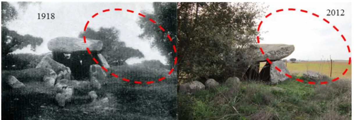
Different trends of montado gain and loss, as well as different driving forces acting in the montado landscape change process have been occurring over time. A long-term analysis carried out by Ferreira (2001) indicates that montado land cover in southern Portugal has experienced profound changes in the last 100 years (Figure 1). These changes were clearly related to particular socioeconomic, political, technological, natural and cultural driving forces that vary across and within particular periods and regions.
Figure 1 – Example of montado landscape conversion to crop/pasture lands in southern Portugal (Cabeção Village)
Around the year 1880, practically all Europe underwent a serious crisis in the agricultural sector due to the invasion of cheaper agricultural products (mainly cereals) from the U.S.A., Canada, Argentina and Russia (Reis, 1979; O’Rourke, 1997; Swinnen,
Chapter 1 - Introduction
10
2009). In Portugal, due to this crisis and the high price of fertilisers (superphosphate), the agricultural sector was not economically viable for landowners. In order to reverse the agricultural crisis, the first supportive regulations for wheat production were published, which included a review of wheat prices to higher values as well as the implementation of import barriers in order to protect national producers (“Elvino de Brito Cereal Law”; Reis, 1979). The interaction between the wheat policies protection, the significant decrease in superphosphate prices and the abundant human workforce availability, caused the rapid expansion of cultivated areas with arable crops (mainly wheat). This crop increase was inversely proportional to the charneca area dimension (a
maquis type land cover, where bushes and shrubs dominate the Quercus spp. trees),
since charneca clearing for dense bush and shrub removal provided open extensive areas for cultivation and/or for restoring the grassland natural pasture (Carvalho, 1870; Crespo, 2006). During these cleaning operations, scattered holm and cork oak trees were maintained due to the manual operations operated by human workforce and by using traditional narrow pulled by animals (Bugalho et al., 2009). During this process, the area of arable crops increased and the montado area also benefited as a sub-product of charneca clearance driven by cereal cultivation. This montado formation stage, which mainly occurred between 1880 and 1920, reflects the reduction in charneca area and a strong increase in montado area (Ferreira, 2001). Indeed, it was estimated that
montado ecosystem covered an area of about 370,000 ha in 1867 and 868,850 ha in
1902 (Vieira, 1991).
With the establishment of the dictatorial regime of government in Portugal (1926–1974) the cereal agriculture was the object of a new reform, with the so-called “Wheat Campaign” implemented in 1929, in order to increase its national production (Saraiva, 2010). The increase in montado area in the first quarter of the 20th century was gradually replaced by a large degradation stage (Ferreira, 2001) due to the first wave of agricultural mechanisation started in the middle of 1930s (Leeds, 1983). This degradation stage was markedly higher from 1950 until the early years of the 1960s, where the use of fertilisers and machinery received intensive financial support. With an increase in agricultural mechanisation, traditional montado management was progressively replaced by less labour demanding practices. As the labour demand decreased, the rural depopulation trends started, and progressively, when needed, the
Chapter 1 - Introduction
11
required day-wage labor was more difficult to arrange. The synergy among the “Wheat Campaign” goals, and the progressive mechanisation constituted a significant driver in agricultural land expansion, as thousands of hectares of land in southern Portugal were cleaned and intensively cultivated with wheat, even in the poorest soils (Natividade, 1950). The intensive cereal cultivation between 1930–1960 (Figure 2) has led to soil depletion; destruction of the natural regeneration process of cork and holm oak; and partial or total elimination of trees towards open fields for cereal cultivation, with more negative impacts on marginal soils (Ferreira, 2001; Pinto-Correia and Vos, 2004; Mendes, 2007). The gradual development of farm mechanisation led to the general use of wide plows, disc harrows and scarifiers (Bugalho et al., 2009). According to the same author, this heavy machinery unselectively destroys young trees and damage the roots, therefore weakening established trees. Another relevant problem for montado conservation arrived with the propagation of African swine fever in the 1960s. Pig ranging, with the Iberian balck pig, was so far one of the most spread livestock use of the montado, as pigs profit in the best way from the acorns feed value. This disease prophylaxis implied the prohibition of grazing pigs, accelerating therefore the destruction of significant areas of holm oak montado to promote more open grazing areas for cattle, or even other land use types with better economic returns (Crespo, 2006).
Figure 2 – Evolution of cereal crops area (ha) in southern Portugal since 1935 until 1999. Data used to perform the graph was obtained from official agriculture statistics available in https://www.ine.pt.
After the establishment of democracy in 1974, an agrarian reform was implemented (1975–1979) and intensive cereal production returned, mainly in the
180 000 380 000 580 000 780 000 980 000 1 180 000 1 380 000 1935 1939 1943 1947 1951 1955 1959 1963 1967 1971 1975 1979 1983 1987 1991 1995 1999 C rops ar ea ( ha) Entry in EU (1986)
wheat, corn, oats, rye and barley
Chapter 1 - Introduction
12
abandoned montado areas. This new intensification phase was short-lasting but very aggressive due to the intensive use of heavy machinery, as many trees were uprooted (Ferreira, 2001). Therefore, the trends of montado decrease observed in this period reflect, in particular, the holm oak montado decline caused by the propagation of swine fever, use of heavy machinery and intensive cereal cultivation.
From 1980 to 2000, changes in the economic context of farming mainly induced by several financial support programs of pre and post-adhesion to the European Economic Community (EEC) in 1986 and consequently to the Common Agricultural Policy (CAP), led to an increase in difficulties for maintaining the traditional agricultural system. Under such EEC policies, in particular those with more focus on southern Portugal, montado land use and its respective options of management strategies were mostly determined by CAP subsidies, instead of by management strategies based on montado singularities and needs (Pinto-Correia and Mascarenhas, 1999). During the first decade of Portugal in the EEC (1986–1996), livestock, together with sunflowers and tomatoes, were the most profitable activities for the private agroforestry economy (Jones et al., 2011). The economic attractiveness of the CAP incentives for livestock production (where cattle gets by far the highest payment), supported by payments to farmers based on a per-head basis, the so-called coupled payments (Bugalho et al., 2011), led many landowners to intensively explore this financial support. As a consequence large montado areas were intensively grazed with severe negative impacts for the balance of the system. On another side, since 1990, European Union (EU) policies have stimulated the implementation of large areas of new cork oak plantations, in particular in set-aside agricultural lands. These new plantations have mainly been established as forestry, due to the EU goals, and thus in this particular case, aiming for cork production purposes. Consequently they presented higher stand densities than traditional agroforestry systems (Coelho et al., 2012). It is known that between 1990 and 2000, 84,000 ha of cork oak were planted in Portugal (Pereira et al., 2010). Nevertheless, these new plantations of cork oak may not be interpreted as a compensatory measure for the huge mature montado loss that occurred over the last 100 years. In fact, the loss of mature montado areas during this period may constitute a strong influence on environmental processes, including potential regional climate
Chapter 1 - Introduction
13
changes, loss of biodiversity, reduction in water quality and ecological functions (e.g. Ferreira, 2001; Lee et al., 2009; Polasky et al., 2011; Wimberly and Ohman, 2004).
Relevant studies on montado/dehesa landscape dynamics and their respective driving forces have been conducted in Spain and Portugal, mostly by relating the spatial and temporal changes of this landscape with several drivers (Acácio et al., 2009, 2010; Brasier, 1996; Camilo-Alves et al., 2013; Catry et al., 2012; Costa et al,. 2008, 2010; Cubera and Moreno, 2007; David et al., 1992; Díaz-Delgado et al., 2002; Guiomar et al., 2015; Linaldeddu et al., 2013; Moreira et al., 2006; Pelegrín et al., 2008; Pérez-Sierra et al., 2013; Pinto-Correia, 1993; Pinto-Correia and Vos, 2004; Plieninger, 2006, 2007; Sheffer, 2012; Vicente and Alés, 2006). Despite the existence and recognition of this huge amount of studies dedicated to the montado/dehesa landscape change analysis and respective drivers, some issues are still remaining and need to be studied (e.g. what are the relative effects of environmental and land management factors in montado loss process at a broader scale?). In addition, there is still plenty of room for improving the understanding of montado landscape change process as a whole. This may be done through the use of spatial data which production and application are supported by the development of robust and cost-effective remote sensing-based methodological approaches for assessing the spatio-temporal patterns of montado changes.
1.3.2. Earth Observation Satellites and montado monitoring
Satellite-based Earth observation is the process of studying the Earth and its environment through the so-called remote sensing technique. Remote sensing can be described as the science of obtaining information about an object, area or phenomenon through the analysis of data acquired by a device that is not in contact with this same object, area, or phenomenon under investigation (Lillesand and Kiefer, 2000). The electromagnetic energy sensors existing in Earth-orbiting satellites acquire data while earth surface features emit and reflect electromagnetic radiation, being these data posteriorly analysed in order to provide information about the surfaces under investigation.
Earth Observation Satellites (EOS) are artificial satellites intentionally placed into orbit to monitor the Earth from space, acquiring global observations of the land
Chapter 1 - Introduction
14
surface, biosphere, solid Earth, atmosphere and oceans (NASA´s Earth Observing Systems, Project Science Office, 2015). Earth orbiting-satellites constitute the most relevant way for providing information on Earth physical, chemical and biological systems at both small and global scales. EOS provide advanced space technology able to map, measure and monitor how, when and where Earth surface and resources are changing across the globe for long periods of time, in an effective, synoptic, systematic and consistent way (Townshend et al., 2008). The era of EOS started around 60 years ago with the launch of the first artificial satellite, Sputnik 1, by the Soviet Union (NASA History Program Office, 2015). Since the launch of Sputnik 1, satellite instrumentation and missions performance have become more and more sophisticated due to the technological development in spaceflights and remote Earth observations systems. The paradigm of Earth observations from space literally changed at the beginning of the 1970s with the emergence of the NASA´s Landsat Program (NASA History Program Office, 2015). The Landsat program provides the largest temporal records of space-based Earth observations, having been acquiring images of Earth’s surface for more than 40 years (Roy et al., 2014). In 1972 Landsat 1 was launched, and between 1975 and 2013 six more Landsat missions were successfully launched to the space: Landsat 2 (1975), Landsat 3 (1978), Landsat 4 (1982), Landsat 5 (1984), Landsat 7 (1999) and Landsat 8 (2013).
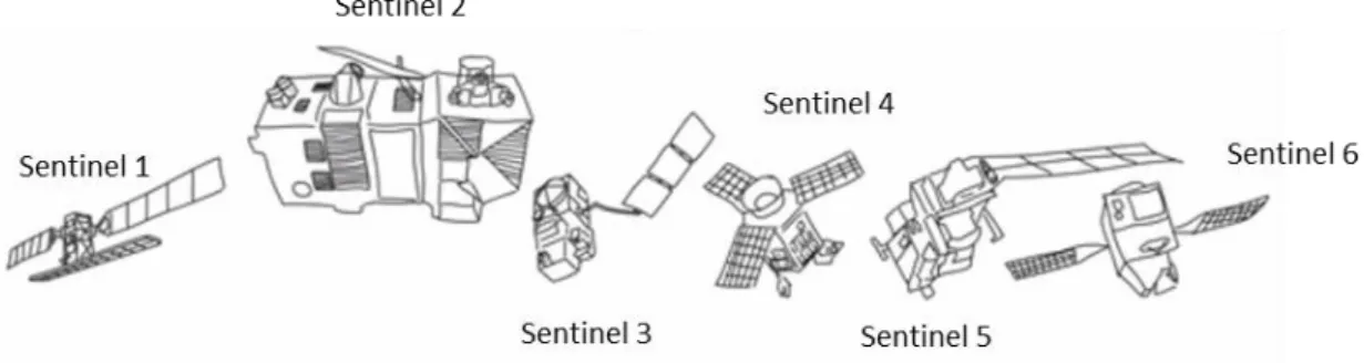
Since 1972, and including Landsat platforms, 197 individual satellites with a global land cover observing capacity have been successfully launched, of which 98 were still operating at the end of 2013 (Belward and Skøien, 2015). One of the most recent and ambitious Earth observation project is the Copernicus Program from the European Commission (EC) in partnership with the European Space Agency (ESA). In general, this program aims providing accurate, up-to-date and easily accessible satellite-based information in order to support scientific research and policy-making in the fields of environmental management, climate change and civil protection (ESA, 2015). To achieve the main goals of Copernicus Program, ESA is developing a constellation of satellites called Sentinel, which will be launched over time until 2021 (Figure 3). Regarding this Sentinel satellites constellation, Sentinel 1 (acquiring and providing high-resolution Synthetic Aperture Radar data) and Sentinel 2A (acquiring and providing high-resolution multispectral data) are already operational and sending
Chapter 1 - Introduction
15
information to the Earth. Sentinel 2B will be launched in 2016 and together with Sentinel 2A they will both provide a global coverage of the Earth's land surface every 5 days.
Figure 3 – Sentinel satellites constellation (Source:
http://www.esa.int/Our_Activities/Observing_the_Earth/Copernicus/Sentinel-2)
Concerning the national participation in the European Space and Earth Observation sectors, Portugal contributed to ESA programmes with a total value of 111,5 M€ between 2000 and 2009 (Clama Consulting, 2011), demonstrating the strategic importance of these sectors for Portuguese authorities. Indeed, to increase the use of Sentinel satellites data in different sectors and domains, the Directorate-General for the Territory (DGT) and the Portuguese Institute for Sea and Atmosphere (IPMA) recently announced the projection and development of the IPSentinel digital infrastructure (DGT, 2015). This infrastructure will constitute a strategic and multifunctional platform for consulting and accessing both Copernicus ground truth data and Sentinel satellites data acquired for the whole national territory.
Regarding the montado ecosystem, which is the case study addressed in this Doctoral project, it is expected that Sentinel 2A and 2B will bring together new research opportunities due to their high spatial, spectral and temporal resolutions (e.g. detailed analysis of ecophysiological responses of montado trees to drought events). With the upcoming Sentinel data and with more than 30 years of archived data from the US Landsat Earth-observing satellites, both provided free of charge, a deeper understanding of the past, present and future of montado landscape dynamics may be boosted, as well as a relevant improvement of the knowledge related to montado’s resilience regarding the synergistic effects of unsustainable land management and climate changes.
Chapter 1 - Introduction
16
Theoretically, spatio-temporal montado landscape change analysis can be performed at a spatial resolution of 30 meters since 1982, by using remote sensing information acquired by the Landsat Thematic Mapper (TM), Enhanced Thematic Mapper Plus (ETM+), and Landsat Operational Land Imager (OLI). Spatial and spectral resolutions of multispectral and thermal data acquired by these Landsat sensors make it suitable for mapping, quantifying and monitoring land cover and land surface biogeophysical properties, and also for better understanding how changes in land surface can affect local and regional climate (Hansen and Loveland, 2012; Wulder et al., 2012; Bonan, 2008). These sensors have been collecting imagery data in the visible, near infrared (NIR), and shortwave infrared (SWIR) portions of the electromagnetic spectrum, making them appropriate for vegetation studies across a wide range of environments (Bhandari et al., 2012; Cohen and Goward, 2004; Jia et al., 2014; Li et al., 2014). However, deriving montado land cover information from satellite-based remote sensing data is a complex and challenging task. Nevertheless it constitutes an effort that needs to be widely undertaken in order to produce more accurate spatial information of this ecosystem. The spatial fuzziness of montado caused by its tree density variability (Doorn and Pinto-Correia, 2007) associated with dry climate and the occurrence of bare soils, determine the spectral separability between montado and other Mediterranean land cover types. The high reflectance from bare soils can overwhelm the reflected components from sparse vegetation such as some montado areas (Berberoglu et al., 2000, 2007; Rodriguez-Galiano and Chica-Olmo, 2012). Multi-seasonal images and vegetation indices have been successfully included in the classification process in order to increase the separability between land cover types with similar spectral behaviour (Dash et al., 2007; Gartzia et al., 2013; Li et al., 2011; Oetter et al., 2001; Rodriguez-Galiano et al., 2012a; Senf et al., 2015).
The potential of moderate resolution EOS for periodically and consistently producing accurate montado spatial information to support long-term monitoring studies in southern Portugal, has never been specifically addressed by the scientific community. Considering the spatial, spectral and radiometric resolutions of Landsat data; and considering also the existence of more than 30 years of archived information as a strategic asset, a relevant research question must be addressed: it is possible to produce accurate montado land cover maps using such data? This Doctoral project aims
Chapter 1 - Introduction
17
to address this specific question by testing the integration of multi-seasonal images and vegetation indices into a remote sensing-based methodological approach including also the application of an advanced machine learning algorithm.
1.3.3. Biogeophysical effects of montado cover changes
Climate changes due to the increasing concentration of greenhouse gases and aerosols in the atmosphere have attracted the attention globally from a diverse community including both politicians and scientists. However, crucial issues focused on the research of the climatic impact of land cover and land use changes through biogeophysical processes is far from resolved (Deng et al., 2014).
Land cover and land use changes have an impact on the climate through changes in biogeochemical (e.g. atmospheric CO2 concentrations) and biogeophysical (e.g. land
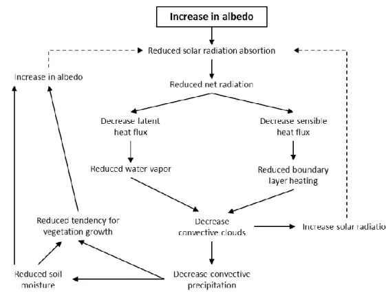
surface albedo, land surface temperature, roughness length, evapotranspiration) processes (Betts et al, 2007; Devaraju et al., 2015; Li et al., 2015). These two processes regulate the fluxes and exchanges of energy, water, momentum, and chemical components between Earth surface and atmosphere, shaping meteorological conditions (Bonan, 2008). Regarding the effects of land cover change in these processes, recent studies have been arguing that changes in biogeophysical processes play a more regional/local role than biogeochemical ones (Li et al., 2015; Pongratz et al., 2010). Land surface albedo (LSA), land surface temperature (LST) and evapotranspiration (ET) are considered as the three most important biogeophysical factors in the whole surface energy and water balance (Dirmeyer and Shukla, 1994; Friedl, 2002; Lu et al., 2011; Mallick et al., 2014). Reduction in vegetation cover due to natural and/or human causes may lead to an increase in surface albedo and consequently to a shrinking in net radiation, energy fluxes (sensible and latent), convective clouds and precipitation, leading therefore to drier atmosphere conditions (Figure 4) (Pitman, 2003). Moreover, a reduction in vegetation cover will also decrease surface roughness, latent and sensible heat fluxes, rooting systems and evapotranspiration rate, leading to land surface warming (Figure 5) (Doughty, 2012; Lejeune et al., 2015; Pitman, 2003).
Chapter 1 - Introduction
18
Figure 4 – Conceptual diagram of possible impacts derived from an increase in surface albedo. Solid lines represent positive feedback and the dashed lines represent negative feedback. Adapted from Pitman (2003).
Figure 5 - Conceptual diagram of possible impacts derived from a decrease in surface roughness. Solid lines represent positive feedback and the dashed lines represent negative feedback. Adapted from Pitman (2003).
Chapter 1 - Introduction
19
European and African Mediterranean regions have received particular attention from the ecological and climate point of view due to the extensive deforestation over the past 2000 years, mainly as a result of the geographical expansion of the Roman Empire (Blondel and Aronson, 2006; Bonan, 2008). According to the research carried out by Reale and Dirmeyer (2000), the Mediterranean region was moister in Roman times. Climate model simulations show that this huge deforestation process across the Mediterranean region over the times contributed to the dryness of the current climate (Arribas et al., 2003; Gates and Lieβ, 2001; Reale and Dirmeyer, 2000; Reale and Shukla, 2000). These studies mostly support the thesis that the greater forest cover during the Roman Era induced higher summer precipitation. Transformation of native Mediterranean forests into crops or grasslands over the times has significantly altered several biogeophysical processes affecting energy and water cycles, which in turn changed temperature and precipitation regimes in this region. Given that, Mediterranean region has been considered highly vulnerable to climate changes (Navarra, 2013). Indeed, the last report of the Intergovernmental Panel on Climate Change (IPCC) is projecting a decreasing trend in precipitation and an increasing trend in temperature for the Mediterranean region. Consequently, this region will be much drier and warmer than today, especially in the warm seasons (Hewitson et al., 2014).
It is understood that land cover changes can alter the environment, causing therefore significant impacts on ecosystems functioning at local, regional and global scales, and consequently greatly influencing global climate changes (Foley et al., 2005; Pachauri and Reisinger, 2007). Local changes gradually extend to regional, inter-regional and even larger scales, leading to global environmental effects. Therefore, in order to determine and assess the main impacts of land cover and land use changes on climate modifications at the global scale, it is mandatory to first understand in detail both local and regional processes (Deng et al., 2014).
Montado/dehesa landscape is one of the most important and widespread
ecosystems in the Mediterranean region. As thoroughly described in the previous section 1.3.1, this ecosystem is in sharp decline, which has been evidenced by a progressive decrease in tree cover (Plieninger and Schaar, 2008). Effects of montado tree canopy cover changes on biogeophysical processes must be addressed at a local
Chapter 1 - Introduction
20
scale in order to be identified, assessed and understood (e.g. what are the effects on land surface albedo and temperature values resulting from a decrease of 50% in tree cover?). This information is extremely important as a starting point to understand how these changes in surface albedo and temperature can influence and/or modify local climate; how montado/dehesa tree productivity and resilience are affected by local climate changes; and how strong are the negative feedbacks presented in the Pitman´s diagrams (Figures 1 and 2) in the case of the montado ecosystem. All these answered questions will contribute to a more efficient and cost-effective montado planning and management decision-making process.
21
Chapter
2
Assessment of environment, land management, and spatial variables on recentchanges in montado land cover in southern Portugal Godinho, S., Guiomar, N., Machado, R., Santos, P., Sá-Sousa, P., Fernandes, J. P., Neves, N., Pinto-Correia, T. Published online in Agroforestry Systems, November, 2014, doi:
10.1007/s10457-014-9757-7 2.1. Abstract
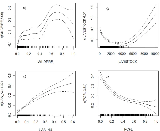
Montado decline has been reported since the end of the 19th century in southern Portugal and increased markedly during the 1980s. Consensual reports in the literature suggest that this decline is due to a number of factors, such as environmental constraints, forest diseases, inappropriate management, and socioeconomic issues. An assessment on the pattern of montado distribution was conducted to reveal how the extent of land management, environmental variables, and spatial factors contributed to montado area loss in southern Portugal from 19902006. A total of 14 independent variables, presumably related to montado loss, were grouped into three sets: environmental variables (ENV), land management variables (LMA), and spatial variables (SPA). From 19902006, approximately 90,054 ha disappeared in the montado area, with an estimated an annual regression rate of 0.14% y-1. Variation partitioning showed that the land management model accounted for the highest percentage of explained variance (51.8%), followed by spatial factors (44.6%) and environmental factors (35.5%). These results indicate that most variance in the large-scale distribution of recent montado loss is due to land management, either alone or in combination with environmental and spatial factors. The full GAM model showed that
Chapter 2 - Assessment of environment, land management, and spatial variables on montado changes
22
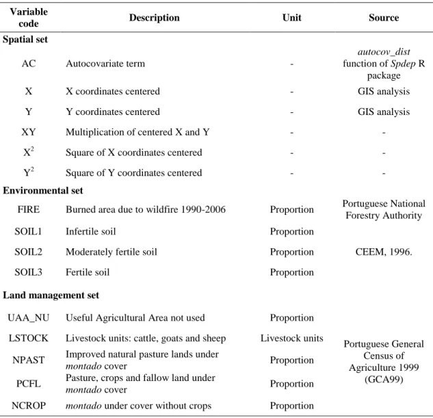
different livestock grazing is one of the most important variables affecting montado loss. This suggests that optimum carrying capacity should decrease to 0.18–0.60 LU ha-1 for livestock grazing in montado under current ecological conditions in southern Portugal. This study also showed that land abandonment, wildfire, and agricultural practices (to promote pastures, crops or fallow lands) were three significant variables influencing montado loss.
Keywords: Landscape change ∙ livestock grazing intensity ∙ montado/dehesa ∙
Mediterranean ∙ Quercus spp. ∙ spatial distribution
2.2. Introduction
The Portuguese montado (such as the dehesa land cover type in Spain) is an agro-silvo-pastoral system in which cork oak (Quercus suber) and/or holm oak (Quercus [ilex] rotundifolia) are the dominant tree species with varying densities usually in combination with livestock grazing and agriculture in the herbaceous layer (Aronson et al. 2009; Pinto-Correia et al. 2011b; Vicente and Alés 2006).
Montado/dehesa areas account for about 3.5–4.0 Mha in the southwestern Iberian
Peninsula, assuming great importance in southern Europe (Olea and San Miguel-Ayanz 2006).
The montado is characterised as an agroforestry multifunctional system, as it produces a range of goods and services currently in demand (Pinto-Correia et al. 2011a; Surová et al. 2011, 2014), including the following: cork; charcoal; firewood; acorns and pasture for livestock; wild game, aromatic, and medicinal plants; and recreational services, such as ecotourism (Bugalho et al. 2009; Coelho and Campos 2009; Joffre et al. 1999; Sá-Sousa 2014). According to Aronson et al. (2009), Coelho et al. (2012), Godinho et al. (2011), Plieninger (2007), and Pulido et al. (2001), the montado also supports other important ecosystems services, such as carbon sequestration, soil conservation, groundwater recharge and quality protection, and biodiversity conservation. Given their environmental and socioeconomic importance,
Chapter 2 - Assessment of environment, land management, and spatial variables on montado changes
23
montado/dehesa systems are regarded as High Nature Value Farmlands (HNVF),
according to European classification criteria (Almeida et al. 2013; Paracchini et al. 2008; Pinto-Correia and Godinho 2013), and are included in Annex I of the European Union Habitats Directive (92/43/CEE).
A decline in montado/dehesa area has been reported throughout the Mediterranean region, especially in Portugal, Spain, Morocco, France, and Italy (Brasier 1996; Cano et al. 2006; Gallego et al. 1999; Linaldeddu et al. 2013). As far as Portugal is concerned, montado decline has been reported since the end of the 19th century and is related to the intensive tree exploitation for charcoal and firewood production, man-made fires to promote open areas for crops and pastures for livestock grazing, failure in juvenile tree regeneration due to livestock browsing, and poorly understood diseases (Carvalho 1870). Surprisingly, most factors indicated in 1870 as threatening the
montado continue to pose a threat today. The significance of such factors in the past is
not known, but as they were highlighted at the time, it is assumed they must have been relevant. Paradoxically, references to threats in the past actually demonstrate the overall continuing resilience of the system, since it has survived the long term despite a number of pressures. Nevertheless, this raises the question of the limits of the montado in terms of sustainability: so far it has survived, but is it sustainable in the future in the face of a range of pressures of various kind (e.g. Bugalho et al. 2009; Cabral et al. 1992; Costa et al. 2010; Leitão 1902; Pinto-Correia and Mascarenhas 1999; Natividade 1950)?
Despite the observed trend of montado decline during the past century, the seriousness of the problem increased markedly during the 1980s (Brasier and Scott 1994; Cabral et al. 1992). A similar increase in the trend toward decline has been reported for the dehesa in Spain (Brasier and Scott 1994; Cano et al. 2003; Moreira et al. 2006; Plieninger 2006). Review of the literature suggests that this decline is mainly related to the following: environmental constraints, such as soil type and hydrological conditions (Costa et al. 2008; Costa et al. 2010; Cubera and Moreno 2007); drought (David et al. 1992; Pelegrín et al. 2008); and wildfires (Catry et al. 2012; Díaz-Delgado et al. 2002; Silva and Catry 2006). In addition, some known diseases (e.g.,
Chapter 2 - Assessment of environment, land management, and spatial variables on montado changes
24
their effects are amplified by the already stressed conditions of the montado (Brasier 1996; Camilo-Alves et al. 2013; Linaldeddu et al. 2013; Moreira and Martins 2005; Pérez-Sierra et al. 2013). Furthermore, there are other factors leading to montado change, including the following: inappropriate management, with a sharp increase in mechanisation and unsustainable livestock stocking rates (Acácio et al. 2010; Cadima et al. 1995; Costa et al. 2010; Del Pozo 2004; Plieninger 2006, 2007); vulnerability of the agricultural economy (Pinto-Correia 2000); rural depopulation; and the abandonment of traditional agricultural activities (Pinto-Correia 1993; Pinto-Correia and Vos 2004; Sheffer 2012). Briefly, such factors are mainly associated with changes in public policies (national and European), market mechanism and other socio-economic factors.
Several studies have examined long-term dehesa change in Spain (Cano et al. 2003; Plieninger 2006) and long-term montado change in Portugal (Acácio et al. 2009, 2010; Costa et al. 2009, 2011), but the focus was always on the local area and/or a single municipality. To support policy decisions regarding montado management, large-scale analyses of changes are needed to understand the overall process and to assess the role of policy.
Thus, the goal of this study is to present the changes detected in the montado distribution pattern for southern Portugal as a whole from 19902006 and determine the relative effects of selected environment, land management, and spatial factors on
montado land cover change. According to the previous considerations regarding montado decline trends, we hypothesise that land management factors play more of a
major role in causing recent montado change than environmental factors.
2.3. Material and Methods 2.3.1. Study area
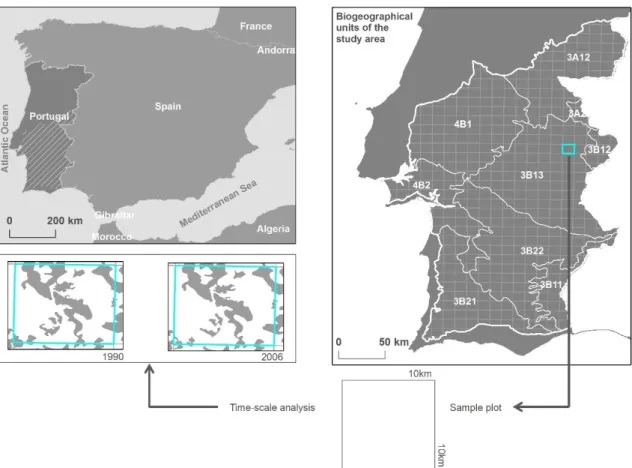
This study was conducted in southern Portugal (Figure 1), a region with vegetation dominated by cork oak (Q. suber) and holm oak (Q. [ilex] rotundifolia) species (Bugalho et al. 2009; Pinto-Correia et al. 2011b). The study area covered approximately 4.1 x 10⁶ ha (Figure 1), which accounts for 46% of mainland Portugal. The selected area is in accordance with published biogeographic boundaries (Costa et
Chapter 2 - Assessment of environment, land management, and spatial variables on montado changes
25
al. 1998), which consist of the following several layers: phytogeographic (flora and vegetation), geomorphologic, lithologic, and pedologic, as well as bioclimate. In fact, about 72% of the area selected is located in the so-called ‘Luso-Extremadurense’ province, one of the largest biogeographic provinces in the Iberian Peninsula. Its soils originate from palaeozoic siliceous material, and the original vegetation associations of Mesomediterranic cork oak (Sanguisorbo agrimoniodis-Quercetum suberis), holm oak (Pyro bourgaenae-Quercetum rotundifoliae), and pyrenean oak (Arbuto
unedonis-Quercetum pyrenaicae) have been converted almost entirely into montado systems.
Figure 1 - Study area, biogeographic boundaries and 10x10 km UTM squares 2.3.2. Cartographic data sources
The areas and distributions of montado land cover in 1990 and 2006 in the study area were obtained from the CORINE land cover (CLC) (scale 1:100,000) of 1990 and 2006. Due to the degree of heterogeneity of tree density and the understory uses of the
montado, this multifunctional system does not entirely fit into a single CLC category
CLC-Chapter 2 - Assessment of environment, land management, and spatial variables on montado changes
26
2006 montado areas, the following land cover categories were used: ‘244-agroforestry areas’, ‘311-broadleaved forest’, and ‘313-mixed forest’. For this procedure, spatial analyses were conducted to accurately extract montado areas using auxiliary geo-referenced data, such as the national land cover map of 1990 (LCM-1990) and the second level of the national land cover map of 2007 (LCM-2007-N2) (both at 1:25,000 scales), produced by the National Centre for Geographic Information and the Portuguese Geographic Institute, respectively. Additionally, data from the National Forest Inventories (IFN-1995 and IFN-2005) produced by the Portuguese Forestry Services as well as high-resolution true-colour orthophotomaps (2005) were also used in particular situations where uncertainty remained after the previously described processes. Thus, for 1990, all patches categorised as ‘montado’ in the LCM-1990 were used, and they were intersected with the 244-, 311-, and 313-land cover categories from the CLC-1990 to extract only the proportion that corresponded to montado areas maintaining the cartographic characteristics of the CLC project. Finally, the same three land cover categories (244, 311, and 313, extracted from CLC-2006) were used to produce the montado map for 2006. These patches were overlaid with all patches classified as ‘heterogeneous agricultural areas’ in the LCM-2007-N2 and the montado areas mapped within each category. The IFN-1995 and IFN-2005 were used to reduce uncertainty in the final classification; visual interpretation and screen-digitised processing of the very high-resolution orthophotomaps served the same purpose.
Trends regarding changes in montado land cover during the 19902006 period were estimated using the UTM grid (with 10 10-km cell size) overlapped on each
montado map to determine the montado area for each year and 10 10-km cell (henceforth simply referred to as cells). A total of 487 cells were examined in the study area, for which montado loss and gain were quantified by comparing the two maps.
2.3.3. Factors affecting montado land cover change
In the period of study (19902006), most of the change in montado land cover was attributed to loss processes, while observed gain values were insignificant
Chapter 2 - Assessment of environment, land management, and spatial variables on montado changes
27
throughout the study area. Thus, the analysis of recent patterns of montado land cover change only focusses on the loss processes.
Factors influencing montado loss were divided into three sets of explanatory variables: environmental (ENV), land management (LMA), and spatial (SPA) (Table 1). The stratification of these factors allows for the study of their combined effects as well as the relative influence on the spatial distribution of montado loss. Furthermore, the SPA set allows whether to quantify SPA influence on distribution of montado loss values or to correct the possible presence of spatial autocorrelation in the data (Borcard et al. 1992; Legendre 1993; Plant 2012).
Table 1 - Variables sets and correspondent explanatory variables description
Variable
code Description Unit Source
Spatial set
AC Autocovariate term -
autocov_dist
function of Spdep R package
X X coordinates centered - GIS analysis
Y Y coordinates centered - GIS analysis
XY Multiplication of centered X and Y - -
X2 Square of X coordinates centered - -
Y2 Square of Y coordinates centered - -
Environmental set
FIRE Burned area due to wildfire 1990-2006 Proportion Portuguese National Forestry Authority
SOIL1 Infertile soil Proportion
CEEM, 1996. SOIL2 Moderately fertile soil Proportion
SOIL3 Fertile soil Proportion
Land management set
UAA_NU Useful Agricultural Area not used Proportion
Portuguese General Census of Agriculture 1999
(GCA99) LSTOCK Livestock units: cattle, goats and sheep Livestock units
NPAST Improved natural pasture lands under
montado cover Proportion
PCFL Pasture, crops and fallow land under
montado cover Proportion
Chapter 2 - Assessment of environment, land management, and spatial variables on montado changes
28
Environmental set
The environmental set is composed of four variables: one of these (FIRE) represents the burnt area from 19902006, and the other three correspond to different soil fertility levels (SOIL1, SOIL2, and SOIL3) (Table 1). The GIS shapefile ‘burnt areas’ was provided by the Institute for Nature Conservation and Forests (ICNF). Soil fertility levels were obtained and adapted from the classification produced for the STRIDE-Amb. 12 final report (CEEM 1996). Fire and soils variables were superimposed on the 10 10-km grid layer using GIS software (ArcGis 10 and ESRI 2011), and proportional values for each variable were extracted for each 10 10-km cell.
Land management set
The five variables comprising the land management set were obtained from the Portuguese General Census of Agriculture (GCA) carried out in 1999 (Table 1). The GCA information is provided at the parish level. Indeed, data of the five variables were extracted for each 10 10-km cell by calculating the proportional area by parish within each 10 10-km cell. These five variables include the following: UAA_NU, the proportion of useful agricultural area not used in each 10 10-km cell, which was used as an indirect measure of rural abandonment; LSTOCK, the estimated grazing intensity obtained by converting cattle, goat, and sheep numbers into livestock units (LU), while the LU of each livestock type was summarised to obtain total LU per 10 10-km cell; NPAST, the proportion of area under montado cover occupied by improved natural pasture land; PCFL, the proportion of area under montado cover occupied by pasture, crops, and/or fallow land; and NCROP, the proportion of area under montado without crops.
Spatial set
The spatial set is composed of six variables: three basic (X, Y, and AC) and three derived variables (XY, X2, and Y2) (Table 1). It is well known that land cover data exhibit spatial autocorrelation, meaning that closest pairs of points have the tendency to