1Serviço Geológico do Brasil – Superintendência Regional de Manaus – Manaus (AM), Brazil. E‑mails: [email protected]; [email protected];
[email protected]; [email protected]
2Guyana Geology and Mines Commission (GGMC) – Georgetown, Guiana.E‑mails: [email protected]; [email protected]; [email protected];
[email protected] *Corresponding author.
Manuscript ID: 20160139. Received in: 12/09/2016. Approved in: 02/03/2017. ABSTRACT: he Geological and Geodiversity Mapping binational program along the Brazil‑Guyana border zone allowed reviewing and in‑ tegrating the stratigraphy and nomenclature of the Roraima Supergroup along the Pakaraima Sedimentary Block present in northeastern Brazil and western Guyana. he area mapped corresponds to a bufer zone of approximately 25 km in width on both sides of the border, of a region extending along the Maú‑Ireng River between Mount Roraima (the tri‑ ple‑border region) and Mutum Village in Brazil and Monkey Mountain in Guyana. he south border of the Roraima basin is overlain exclusively by efusive and volcaniclastic rocks of the Surumu Group of Brazil and its correlated equivalent the Burro‑Burro Group of Guyana.
KEYWORDS: Roraima Supergroup; Brazil‑Guyana border; stratigraphy.
RESUMO:O programa binacional de Mapeamento Geológico e da Geodiversidade na fronteira Brasil‑Güiana possibilitou a revisão e inte‑ gração da nomenclatura estratigráica do Supergrupo Roraima ao longo do Bloco Pacaraima nas regiões extremo norte brasileira e ocidental guia‑ nense. A área corresponde a um bufer de aproximados 25 quilômetros a partir da fronteira, em um trecho deinido pelo Monte Roraima (região de tríplice fronteira) e vizinhanças da vila Mutum, no Brasil, e serra Monkey, na Guiana, ao longo do rio Maú ou Ireng. O lanco sul da bacia assenta exclusivamente em rochas efusivas e vulcanoclásticas dos correlatos grupos Surumu e Burro‑Burro.
PALAVRAS‑CHAVE:Supergrupo Roraima; Fronteira Brasil‑Guia‑ na; estratigraia.
Stratigraphy of the Roraima Supergroup
along the Brazil‑Guyana border in the
Guiana shield, Northern Amazonian
Craton – results of the Brazil‑Guyana
Geology and Geodiversity Mapping Project
Estratigraia do Supergrupo Roraima ao longo da fronteira Brasil‑Guiana
no escudo das Guianas, norte do Cráton Amazônico – Resultados do
Projeto Mapeamento Geológico e da Geodiversidade Brasil‑Guiana
Nelson Joaquim Reis1*, Serge Nadeau2, Leda Maria Fraga1, Leandro Menezes Betiollo1, Maria Telma Lins Faraco1, Jimmy Reece2, Deokumar Lachhman2, Randy Ault2
INTRODUCTION
he Pakaraima Sedimentary Block (PSB) (Reis & Carvalho 1996, Reis & Yánez 2001) represents a stratigraphical land‑ mark of the Roraima Supergroup, being the register of a Paleoproterozoic sedimentary basin in the northern portion of the Amazon Craton (Fig. 1). Of unparalleled scenic beauty, it gathers a dozen tepuys, which stand out Mount Roraima, a triple frontier between Brazil, Venezuela and Guyana (Reis 2009). he basin register a historical gold and diamond mining activity in a stratigraphic framework poorly investi‑ gated and deserving attention at the application of sequence stratigraphy, tectonic setting and geochronological studies.
his paper discusses the correlation of the stratigraphy of the Roraima Supergroup on both sides of the border
of Brazil with Guyana, based on the work performed during the Geological and Geodiversity (land‑use) Mapping of the Brazil‑Guyana Project, carried out by geologists of the CPRM — Geological Survey of Brazil and the GGMC — Guyana Geology and Mines Commission. he area of geo‑ logical mapping includes the three main villages of Uiramutã and Mutum on the Brazilian side and Orinduik on the Guianese side, all of them located within that bufer zone of 25 kilometers on both sides of the frontier (Fig. 2). In spite of the bad weather conditions and the impossibility to drive along the dirt roads between Karasabai Village and Monkey Mountains, it was possible to reach Orinduik by plane. During the light, it was possible to observe an inter‑ esting area of the Roraima Supergroup where the irst sedi‑ mentary rocks form clifs overlying the Iwokrama volcanics
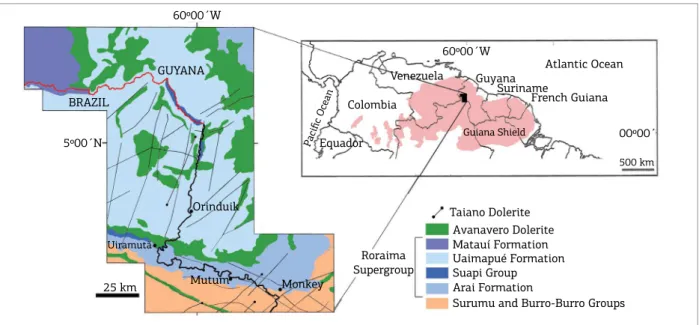
Figure 1. The PSB along the Venezuela, Brazil and Guyana border and the regional geological setting of the Guiana Shield.
BRAZIL
GUYANA 60º00´W
5º00´N
Orinduik
Uiramutã
Mutum Monkey
25 km
Equador Pacific Ocean
Colombia
Venezuela Guyana Suriname
French Guiana Atlantic Ocean
Guiana Shield
60º00´W
00º00´
500 km
Roraima Supergroup
Taiano Dolerite
Matauí Formation Avanavero Dolerite
Uaimapué Formation Suapi Group Arai Formation
Surumu and Burro-Burro Groups
Figure 2. Simpliied geological map of the Pakaraima Sedimentary Block along the Brazil and Guyana border and
the location of the Guiana Shield, north of the Amazon Craton.
Phanerozoic Cover LATE OROSIRIAN CALIMIAN
Pakaraima Sedimentary Block – PSB (> 1.78 Ga)
Undifferentiated (1.90 – 1.43 Ga)
EARLY OROSIRIAN
Rio Urubu Igneous Belt – RUIB (1.94 – 1.93 Ga) Orocaima Volcano-Plutonism – OVP (1.98 – 1.95 Ga) Cauarane-Coeroeni Belt – CCB (~2.00 Ga)
Trairão-Anauá Arc (2.04 – 2.02 Ga)
RHYACIAN
Granulites/Charnockites Bakhuis – B (2.06 Ga) Granite-Greenstone Belt (and gneisses) (2.21 – 2.07 Ga)
ARCHEAN
Imataca (IB) and Amapá Block (AB)
South America
Andes Belt Braziliano Belts Cratons Amazonian Craton 1-Guiana Shield 2-Brazil-Central Shield
SIMPLIFIED GEOLOGICAL MAP OF GUIANA SHIELD
10´N
Atlantic Ocean
and where tufs of the Uaimapué Formation are forming hills and plateaus. Another landscape feature observed was the rainforest distribution developed over the hills of basic rocks, occurring as dyke and sill intrusions of the Avanavero Dolerite. he interpretation of the landscape was an import‑ ant tool to identify the units of the Roraima Supergroup in Guyana, once the stratigraphy has been deined by previous and detailed mapping work on the Brazilian side.
REGIONAL GEOLOGICAL SETTING
The Roraima Supergroup is part of the Pakaraima Sedimentary Block, forming a continuous area of sedi‑ mentary rocks covering some 73,000 km2 of the Guiana
Shield in parts of Venezuela, Brazil and Guyana (Fig. 1). Using the geochronological provinces subdivisions deined by Tassinari and Macambira (2004), the PSB will be part of the Maroní‑Itacaiúnas Province with ages ranging between 2.2 and 1.9 Ga. On the other hand, it will belong to the Tapajós‑Parima Province proposed by Santos et al. (2006), with ages varying between 2.03 and 1.88 Ga.
The Roraima Supergroup, whose sediments have been deposited throughout the Orosirian period of the Paleoproterozoic Era, has maximum and minimum ages of 1.95 and 1.78 billion years, respectively (Tab. 1). Zircons from tuffs within the Uaimapué Formation yielded a U‑Pb SHRIMP age of 1873 ± 3 Ma (Santos et al.
2003). he minimum age of the Roraima Supergroup is 1795 ± 2 Ma and 1782 ± 3 Ma and was determined by U‑Pb geochronology using baddeleyite and zircon from two maic sills (Avanavero magmatism) possibly suggesting two pulses
of magmatism during the Avanavero event (Santos et al.
2003, Reis et al. 2013). he main sources of sediments of the Arai Formation were rocks of Trans‑Amazonian age (2.26 – 2.01 Ga), as indicated by the main population of detrital zircons at 2123 ± 14 Ma. he second source was rocks with an age of 1958 ± 19 Ma (Santos et al. 2003), probably related to the Orocaima Event which included Surumu calc‑alkaline volcanic rocks and its plutonic equiv‑ alents of the Pedra Pintada Suite granitoids (Reis et al.
2000a) and from Iwokrama volcanic rocks and its plu‑ tonic equivalents.
he Roraima basin along the southern border of the PSB unconformably overlies volcanic rocks of the Surumu Group and Iwokrama Formation (Burro‑Burro Group) in the Brazilian and Guyanese terranes, respectively, forming an elongated E‑W trending belt. These rocks show a prominent mylonitic foliation, which has been attributed to the regional deformation of the crust during the K’Mudku episode around 1.2 Ga. No contacts were observed between the sedimentary rocks of the Roraima Supergroup with the comagmatic granitoids of the volca‑ nic rocks of the Surumu and Burro‑Burro Groups. At the base of the Roraima Supergroup, where the sedimen‑ tary rocks were locally tightly to gently folded, they only present traces of low‑grade metamorphism in the zeolite facies. hermal metamorphism is always present along the contact of the Avanavero intrusive bodies (Pinheiro et al.
1990). Swarm of dolerite dykes dated at around 200 Ma (Nomade et al. 2007) cut all of these older rocks, mainly in a NE‑SW direction, extending over more than 70 km for the Tumong Dyke located near the Brazil‑Guyana bor‑ der, to the southeast of Orinduik village.
Table 1. Stratigraphy of Roraima Supergroup proposed by Reis and Yánez (2001) along the Brazil – Venezuela
border and it extension to Guyana. Compilation of ages of the volcanic rocks underlying the Roraima Supergroup along the border between Brazil and Guyana (Surumu Group and Iwokrama Formation), of a pyroclastic rock unit
of the Uaimapué Formation in Brazil and of intruding sills of the Avanavero Dolerite in Brazil.
Brazil‑Venezuela Stratigraphy as proposed
by Reis and Yanez (2001) Keats (1973) Main U‑Pb and Pb‑Pb Ages
Roraima Supergroup
Avanavero Magmatism 11787 ± 14 (bd); 11782 ± 3 (zr); 21795 ± 2 (bd);
Matauí Formation Unit X
Uaimapué Formation Unit IX 11873 ± 3 Ma
Suapi Group
Quinô Formation Unit VII and VIII Cuquenán Formation Unit VI
Pauré Formation
Unit V Verde Formation
Uiramutã Formation
Arai Formation Unitn I to IV 1detrital zircons: 2123 ± 14 (main); 1958 ± 19 (younger) Pakaraima/Surumu Group Iwokrama Fm. 11984 ± 9; 31989 ± 10; 41966 ± 7; 41964 ± 7; 51982 ± 3
The Roraima basin is interpreted as a rift‑sag setting formed during an extensional tectonic phase in which N‑S general event was responsible for the development of nor‑ mal E‑W faults and transfer faults. It forms an asymmetrical basin of rhombohedric geometry controlled by NW‑SE faults. Later, during the K´Mudku episode times, the basin experi‑ enced a weak positive inversion involving the reactivation of normal upthrow faults and the transfer faults as lateral ramps. At the southern border of the basin, in proximity to the E‑W faults, the rocks of the Roraima Supergroup occur in echelon folds, however, towards the centre of the basin, no deformation of its rock units is recorded, which led to the preservation of its primary stratigraphic relationships (Pinheiro et al. 1990).
Much of the Roraima sedimentary rocks occur within the PSB, although it can be traced over large areas of Venezuela, Brazil, Guyana and Suriname, as suggested by the presence of outliers at Urutanim, Uafaranda, Tepequém, Makari and Tafelberg. However some of these table mountains are believed to be Roraima‑like and overlay volcanic rocks with ages 100 Myr younger than those of the Surumu and Burro‑Burro Groups, as for the Urupi basin in the northeast portion of the Amazonas State. In the same way, the Neblina and Padre Mountains (northwest of the Amazonas State) overlies a basement much younger than the Roraima Supergroup. he Surucucus Formation (northwest of the Roraima State) has a post‑Parguaza age and contains a younger population of clastic zircons at 1551 ± 5 Ma (Reis et al. 2000b). herefore, these overlying sedimentary outliers present distinct stra‑ tigraphy which appear diachronous to the tectonic history of the PSB and some revision of these ten type‑localities is needed before attempting to correlate them, as was pointed out by Reis and Carvalho (1996).
THE RORAIMA SUPERGROUP –
SOME MAIN ADVANCES
he sedimentary cover consists of a thick succession of about 2,770 meters of siliciclastic, pyroclastic and volcaniclas‑ tic rocks whose stratigraphy was investigated over six decades by many geoscientists including Bouman (1959), Reid (1972), Yánez (1972; 1977), Keats (1973), Gansser (1974), Ghosh (1981), Reis et al. (1985; 1988; 1990), Santos (1985), Castro and Barrocas (1986), Barron (1986), Pinheiro et al. (1990), Reis and Yánez (2001), Wankler (2001), Long (2002), Santos et al.
(2003), Minter (2009) and Beyer et al. (2015), among others. In Brazil, Bouman (1959) subdivided the Roraima Formation into three members, with reference to the Arai Mountain region. Reid (1972) was the first to make a detailed stratigraphy of the rocks into four formations that were grouped under the term “Roraima Group” in the Santa
Elena de Uairén area, southeast Venezuela. In Guyana, Keats (1973) deined nine distinctive sedimentary Units (I to IX) of the Roraima sedimentary cover and discussed the envi‑ ronment of deposition, although he made no correlation attempts with Reid’s stratigraphy in Venezuela.
Ghosh (1981) suggested that some sedimentary outliers of luvial‑deltaic to coastal and marine environments of the Sipapu and Paru “cerros” located to the west of the PSB in the Amazonas State of Brazil and in Venezuela were not related to the Roraima’s stratigraphy proposed by Reid (1972) at Santa Elena de Uairén. In Brazil, Santos and D’Antona (1984) proposed a subdivision of the group deined by the work of Reid (1972), into ive formations (from bottom to top: Arai, Suapi, Quinô, Uailã and Matauí). Later work by Reis et al.
(1985) in the Quinô River area proposed to subdivide the Suapi Formation into four members (from bottom to top: Verde, Pauré, Carmã and Nicarã). he Suapi Formation was observed to be in unconformity with the Arai Formation and overlain by the Quinô Formation, although the latter contact was not seen in the ield. More recently, Reis et al. (1988) intro‑ duced the term Suapi Group which included in order from botttom up the Verde, Pauré, Nicarã and Quinô Formations which was made subsequently to the status change of the Roraima proposed by Pinheiro et al. (1990) from Group to Supergroup and to the detailed description of its environment of deposition by Castro and Barrocas (1986).
During the nineties, Reis et al. (1990) showed that the Arai Formation presented characteristics typical of a con‑ tinental sedimentary facies, in contrast to the transitional facies proposed by Pinheiro et al. (1990) based on obser‑ vations in the Upper Member of the Formation. he Serra do Sol Formation that was proposed by Santos (1985) was rejected by the latter authors. he irst integrated stratigra‑ phy correlation between Brazil and Venezuela of the Roraima sedimentary cover was developed by Reis and Yánez (2001) who proposed from the bottom and upwards: he Arai Formation, followed by the Suapi Group (Uiramutã, Verde, Pauré, Cuquenán, and Quinô Formations), the Uaimapué Formation and the Matauí Formation. hese latter authors also abandoned the use of the terms “Nicarã” and “Uailã” and rather introduced the term “Uiramutã (Tab. 2; Fig. 3).
THE STRATIGRAPHY OF THE
RORAIMA SUPERGROUP –
IMPLICATIONS FOR GUYANA
he stratigraphy of the Roraima Supergroup was deined by their respective depositional environments (from base to top):
conglomeratic sandstones, conglomerates and mudstones of continental source (Reis et al. 1990). It displays characteristic features typical of alluvial fan, lacustrine, aeolian sand bodies and braided luvial facies. Among the various levels of con‑ glomerates of the Roraima Supergroup only those of the Arai Formation representing braided luvial environments are eco‑ nomically important since gold and diamonds were mined by pork‑knockers in areas of Venezuela, Brazil and Guyana. However, the main source of alluvial gold and diamonds mined on the Brazilian side of the Roraima Basin are the paleoter‑ races derived from the erosion of the conglomerates of the Arai Formation. hese paleoterraces of Paleogene age belong to the Trincheira Formation of Reis and Pinheiro (2004).
A thick layer of intercalated volcaniclastic and volcanic rocks near the base of the Arai Formation has been important to
deine the basement of the Roraima basin. In the Ichún Tepuy area, southwest Venezuela, Briceño et al. (1989) have described a 2430 meters thick sucession of volcaniclastic and volcano‑ genic rocks which discordantly overlies the efusive rocks of the Cuchivero Group and transitionally underlies the sedimentary rocks of the Roraima. Brooks and Garcia (1999) have mentioned the Carun circular structure in the Bolivar State, Venezuela, as an intact Proterozoic caldera with a diameter of aproximately 15 km in the Cuchivero Province. In a similar way, a volcanic caldera model has been proposed for the Tepequém Mountain, a Roraima sedimentary outlier situated at the southwest portion of the PSB (Reis et al. 2009, Dreher et al. 2011). he stratigra‑ phy of the Tepequém Mountain is dominated by volcanic cob‑ bles‑ and pebbles‑bearing fanglomerates related to the caldera walls (named the Tepequém Formation, a pre‑Roraima unit)
Table 2. Stratigraphy of the Roraima Supergroup in Brazil and in Venezuela through time as proposed by various authors: 1) Bouman (1959); 2) Yánez (1972, 1977); 3) Reid (1972); 4) Reis et al. (1985); 5) Santos (1985); 6) Reis et al. (1988, 1990); 7) Reis and Yánez (2001); 8) Keats (1973). The correlation between the stratigraphy of the Roraima Supergroup in Brazil and Venezuela with the unit subdivisions in Guyana are shown in the last two columns to
the right (this work).
Br - Brazil; Vz - Venezuela; Gu - Guyana
Brazil Venezuela Venezuela Brazil Brazil Brazil Brazil‑
Venezuela Guyana
not
defined
Auyantepui
Formation FormationMatauí not defined FormationMatauí FormationMatauí FormationMatauí Unit X
Quaiquinima
Formation (tf) Uailã Formation (tf) Uailã Formation (tf) Serra do Sol Formation Uailã Formation (tf) Uaimapué Formation
(tf) Unit IX (tf) Uailã Formation (tf) Quinô Member Canaima Formation Quinô
Formation FormationQuinô
Suapi Group
Quinô Formation
Suapi Group
Quinô
Formation Unit VII to VIII
Suapi Member Cuquenán Formation Suapi F ormation Nicarã Member Suapi F ormation Nicarã Member Nicarã Formation Cuquenán
Formation Unit VI Carmã
Member
Carmã Member
Arai
Member FormationUiarén
Pauré Formation Pauré Formation Pauré Formation Pauré Formation Unit V Verde
Formation FormationVerde Verde Formation
Verde Formation
Arai
Formation FormationArai
Uiramutã Formation Arai
Formation FormationArai Unit I to IV (d) not defined (d) Pacairama Group (d) Pacairama Group (d) Surumu Group (d) Surumu Group (d) Surumu Group (d) Surumu and Pacaraima (d) Iwokrama Formation Bouman (1959) Yánez (1972‑
1977) Reid (1972) Reis et al. (1985)
Santos
(1985)
Reis et al.
(1988‑1990) Yánez (2001)Reis and (1973)Keats
1 2 3 4 5 6 7 8
and by quartz pebbles‑bearing conglomerates similar to those of the Arai Formation, in turn overlying those volcanogenic rocks.
Close to the border with Guyana, in the Paiuá Creek and in the surrounding Lilás Mountain, there is a succession
of volcaniclastic rocks adjacent to the basal conglomerates of the Roraima Supergroup. he bottom pyroclastic low shows a basal layer displaying cross‑stratiication sets and rare epiclastic fragments (base surge deposit), followed by
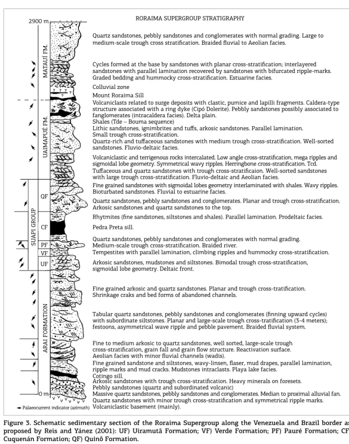
Figure 3. Schematic sedimentary section of the Roraima Supergroup along the Venezuela and Brazil border as proposed by Reis and Yánez (2001): UF) Uiramutã Formation; VF) Verde Formation; PF) Pauré Formation; CF) Cuquenán Formation; QF) Quinô Formation.
2900 m
MA
TA
UÍ FM.
U
AIMAPUÉ FM.
SU
API GROUP
QF
CF
PF VF UF
ARAI FORMA
TION
0 m
Palaeocurrent indicator (azimuth)
RORAIMA SUPERGROUP STRATIGRAPHY
Quartz sandstones, pebbly sandstones and conglomerates with normal grading. Large to
medium-scale trough cross stratification. Braided fluvial to Aeolian facies.
Cycles formed at the base by sandstones with planar cross-stratification; interlayered
sandstones with parallel lamination recovered by sandstones with bifurcated ripple-marks. Graded bedding and hummocky cross-stratification. Estuarine facies.
Colluvial zone
Mount Roraima Sill
Volcaniclasts related to surge deposits with clastic, pumice and lapilli fragments. Caldera-type structure associated with a ring dyke (Cipó Dolerite). Pebbly sandstones possibly associated to
fanglomerates (intracaldera facies). Delta plain.
Shales (Tde – Bouma sequence)
Quartz-rich and tuffaceous sandstones with medium trough cross-stratification. Well-sorted sandstones. Fluvio-deltaic facies.
Lithic sandstones, ignimbrites and tuffs, arkosic sandstones. Parallel lamination. Small trough cross-stratification.
Fine grained sandstones with sigmoidal lobes geometry interlaminated with shales. Wavy ripples. Bioturbated sandstones. Fluvial to estuarine facies.
Quartz sandstones, pebbly sandstones and conglomerates. Planar and trough cross-stratification. Arkosic sandstones and quartz sandstones to the top.
Rhytmites (fine sandstones, siltstones and shales). Parallel lamination. Prodeltaic facies.
Pedra Preta sill.
Volcaniclastic and terrigenous rocks intercalated. Low angle cross-stratification, mega ripples and sigmoidal lobe geometry. Symmetrical wavy ripples. Herringbone cross-stratification. Tcd. Tuffaceous and quartz sandstones with trough cross-stratificaion. Well-sorted sandstones with large trough cross-stratification. Fluvio-deltaic and Aeolian facies.
Quartz sandstones, pebbly sandstones and conglomerates with normal grading.
Medium-scale trough cross-stratification. Braided river.
Tempestites with parallel lamination, climbing ripples and hummocky cross-stratification. Arkosic sandstones, mudstones and siltstones. Bimodal trough cross-stratification, sigmoidal lobe geometry. Deltaic front.
Fine grained arkosic and quartz sandstones. Planar and trough cross-tratification. Shrinkage craks and bed forms of abandoned channels.
Tabular quartz sandstones, pebbly sandstones and conglomerates (finning upward cycles) with subordinate siltstones. Planar and large-scale trough cross-tratification (3-4 meters); festoons, asymmetrical wave ripple and pebble pavement. Braided fluvial system.
Fine to medium arkosic to quartz sandstones, well sorted, large-scale trough cross-stratification, grain fall and grain flow structure. Reactivation surface. Aeolian facies with minor fluvial channels (wadis).
Fine grained sandstone and siltstones, wavy-linsen, flaser, mud drapes, parallel lamination, ripple marks and mud cracks. Mudstones intraclasts. Playa lake facies.
Cotingo sill.
Arkosic sandstones with trough cross-stratification. Heavy minerals on foresets. Pebbly sandstones (quartz and subordinated volcanic)
Massive quartz sandstones, pebbly sandstones and conglomerates. Median to proximal alluvial fan. Quartz sandstones with minor trough cross-stratification and symmetrical ripple marks.
an ash‑low tuf and by ash‑fall tufs containing accretion‑ ary lapilli particles towards the top (Fig. 4).
Otherwise, Reid (1972) has described a long hiatus between lava extrusion and earliest sandstones deposition marked by a paleo‑relief. However, it lacks a comprehensive description between the volcanic basement and sedimentary or possibly volcanogenic rocks in the Santa Elena de Uairén area, Venezuela, whose outcrops are always weathered.
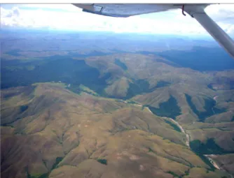
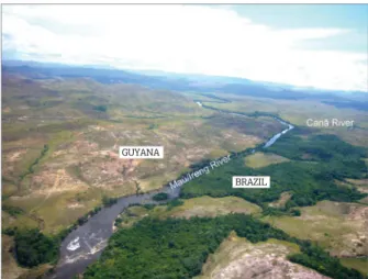
he Arai Formation extends along the Brazilian border to Guyana following the Maú‑Ireng River where it outcrops over a large area which includes Monkey Mountain (Fig. 5).
On the Brazilian side, near Mutum Village, the strata of Arai Formation consist of a folded succession of siliciied sand‑ stones and conglomerates.
he folding of rocks along the border appears to be more prominent on the Brazilian side within the Arai Formation. On the Guyanese side Keats (1973) only mentioned tight folding present in the area of the Merume River, where it is believed that the rocks belong to the basal conglomerates of Unit I of the Roraima Supergroup. Tight to open folds were described by Pinheiro et al. (1990) within Rebenque Creek near Mutum Village and at Lilás Mountain on the Brazilian side of the Ireng River (Fig. 6). Shear zones are common and parallel to the east‑west axial plane of the folds. As a whole, the pattern of folding is believed to represent asym‑ metrical drag folds produced by normal faulting during the K´Mudku episode, as described by CPRM (2016) in the Tepequém Mountain, an outlier of the Roraima Supergroup. hese shear zones cut through the volcanic rocks resulting into pinnacle‑shaped outcrops (Fig. 7). he rocks form prom‑ inent hogbacks with steep dips greater than 30o to the north.
Along the Venezuelan border, in the vicinity of the Santa Elena de Uairén city, the rocks of the Roraima Supergroup were described as consisting predominantly of a gently folded
Arai Formation
Iwokrama Formation
Figure 5. The PSB along the Brazil and Guyana border
near Monkey Mountain. In this aerial view, along the southern border of the basin the Iwokrama volcanics
are directly correlated with the Surumu volcanics
as well as the lower sedimentary rocks of the Arai
Formation of the Roraima Supergroup extends continously in both countries.
A B
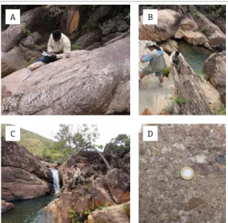
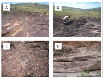
C D
Figure 4. Paiuá Creek. (A) Layer of volcanogenic ferruginous sandstones with small cross‑stratiications covered by pyroclastic lows and cineritic deposits (B);
(C) and (D) Ignimbrite with pumice fragments.
A
C
B
D
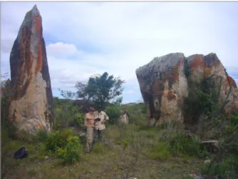
Figure 6. Rebenque Creek in the vicinity of Mutum Village. Limbs of a tight fold dipping to the north
(A) and to the south (B) with shear zones occuring
parallel to the east‑west striking axial plane of the fold. (C) Lilás (Purple) Mountain. Open fold with limbs striking to the north and south; (D) At the foot of Lilás Mountain outcrops of pyroclastic rocks of the Surumu Group as in the Paiuá Creek are mainly composed of lapilli tufs. The contact between the pyroclastic and terrigenous rocks seems to be gradational and the irst
sequence of ine to very coarse‑grained sandstone with sub‑ ordinate conglomerate and mudstone, in turn, cut by a dol‑ erite sill (Reid 1972, Long 2002). On the Brazilian side at this same level the Cotingo sill intrudes the Surumu vol‑ canics over a large area.
According to Keats (1973), it is diicult to correlate the basal conglomerate layers of the Roraima Supergroup from one area to another, since these conglomerates do not show clear diferences in their pebble contents, sometimes with quartz fragments accounting for more than 95% of the pebbles.
he bulk of the irst 150 meters of the Arai Formation is only estimated in the south of Uiramutã Village and in the Mutum Gorge, since tectonic events have modiied the topography of Lilás Mountain and the area of Mutum Village. At these localities the conglomerates are massive (no apparent internal structure), well‑sorted with a clast sup‑ ported framework of pebbles of quartz and lesser amounts of volcanic fragments. hey are interbedded with massive medium‑ and ine‑grained pebble sandstones which grade to quartz sandstones containing trough cross‑stratiications and planar bedded sandstones.
Although the main lithologies of the Arai Formation in the Brazil‑Guyana border area are similar, neither Keats (1973) nor Barron (1986) described aeolian sandstones and lacus‑ trine mudstones and siltstones like those mentioned by Reis
et al. (1990). It is possible that the outcrops on the Guyanese side are not well exposed if they are composed of ine‑grained sedimentary rocks more susceptible to erosion by weathering. However, more recent drilling and detailed stratigraphy work by Minter (2009) and Beyer et al. (2015) on the easternmost side of the Roraima Supergroup in Guyana had identiied sandstones of aeolian origin and mudstones representing lake conditions that probably extended towards the western side of
Guyana and the Brazil‑Guyana border area. Ten formations were described by Minter (2009) with major time breaks, in turn, correlated with the irst ive units deined by Keats (1973). In the same area, Beyer et al. (2015) described two lithofacies associations identiied by major erosional bound‑ ing surfaces, the upper representing lakes and subaerial lats. he Arai Formation of the Roraima Supergroup in Venezuela near Santa Elena de Uairén, was also described as containing thick mudstones representing deposits of temporary lakes under arid climatic settings (Long 2002).
hose lacustrine mudstones and aeolian arkosic sand‑ stones in Brazil appear in the vicinity of the gravel road to Uiramutã Village and are shown in Figs. 8 and 9, respectively.
Figure 7. Gravel road to Mutum Village. Shear zones
cutting the pyroclastic rocks of the Surumu Group
resulted in the formation of pinnacles with prominent
foliation striking E‑W with down‑dip lineation.
A
C
B
D
Figure 9. Gravel road to Uiramutã Village (dunes ield). (A) Fine and friable pinkish arkosic sandstones interpreted
as aeolian dunes; (B) Reactivation surface between sets
of large‑scale trough cross‑stratiications; (C) View of a major trough displaying cross‑stratiication with palaeocurrent low direction to the NE; (D) Grain fall and grain low structures present in the arkosic sandstones,
very common in aeolian settings by grain avalanches on the slip faces of sand dunes (see arrows and coin for scale).
A B
Figure 8. Gravel road to Uiramutã Village. (A)
Symmetrical ripple‑marks (lower low regime) at
the top of sets of compact and reddish mudstones
interpreted as playa‑lake deposits associated with
hey were irstly described by Castro and Barrocas (1986) and Pinheiro et al. (1990). hese rocks overlain quartz sandstones and conglomerates of the Arai Formation and are believed to be deposited in a more distal position of an alluvial fan. he lacustrine siltstones and mudstones are interbedded with intraformational conglomerates in which the ripple‑ mark cosets contain pelite intraclasts. hey are interpreted to correspond to lacustrine turbiditic sequences. Symmetrical ripple marks and mud‑cracks are common at the top of the thin sets of beds forming a network of structures in outcrops of the Suapi River (Pinheiro et al. 1990).
Pinkish arkosic sandstones are fine‑ to medium grained, well‑sorted and form thick layers with large‑scale trough cross‑stratification. Reactivation surfaces sepa‑ rate the sets of these cross‑stratifications. The cross‑sets become progressively flatter and thinner at the top of the dunes. Internal structures of grain size grading and grain flow direction are observed. These sedimentary rocks contrast with quartz sandstones forming more pink to whitish color rounded hills on the side of valleys. To the top of the aeolian bed sequences corresponding to dune sandbars they appear to be cut by braided flu‑ vial deposits which were also in turn covered by addi‑ tional sand dune deposits.
It is concluded that a regional unconformity is present between the lower lacustrine mudstones, siltstones and aeo‑ lian arkosic sandstones with the upper conglomerates and quartz sandstones. Fragments of siliciied sandstones into ine to medium arkosic sandstones are believed to have been carried by temporary streams (wadis).
Towards the upper part of the Arai Formation there is a thick succession of quartz‑rich sandstones, pebbly sand‑ stones and conglomerates interbedded in a ining upwards cycles. It is interpreted in terms of deposition in a luvial environment composed of braided rivers. he pebbly sand‑ stones were dominantly deposited as channel sand bars and large‑scale trough cross‑stratiications (Fig. 10). Paleocurrent measurements trend to the SW indicating sourcing is from the northeast (Reis et al. 1990).
In this paper, Units I to IV of Keats (1973) can be cor‑ related with the Arai Formation based on several common features:
■ A common deposition environment and history starting from the correlation of the basement rocks of the Surumu and Iwokrama rocks in Brazil and Guyana, respectively. he main sources of sediments of the Arai Formation were rocks of Trans‑Amazonian age showing common sources from the greenstone belts in the northernmost portion of Guyana and Venezuela;
■ Conglomerates, pebbly sandstones and arkosic sand‑ stones displaying ining upwards luvial cycles;
■ Large river channel deposits with large‑scale trough cross‑beds and unimodal palaeocurrent distributions to the southwest (Fig. 11);
■ Vertical and lateral facies associations, sand‑body geom‑ etry and mainly by their lithofacies;
■ Similar physiography of the terrigenous sedimentary rocks of the Arai Formation on the Brazilian side of the border area and extension to the Guyanese side, forming clifs where quartz‑rich sandstones and conglomerates are well‑preserved in relation to the arkosic sandstones;
■ It is also possible to correlate the lithostratigraphy of the Merume, Potaro, Karanang and Monkey Mountain areas in Guyana with those from Mutum and Uiramutã areas on the Brazilian side;
■ here is also similarities in the main features of the environ‑ ment of depositions in Brazil, Guyana and Venezuela. Keats (1973) had described a proximal to distal luvio‑deltaic dep‑ ositional environment for Units I to IV. On the Brazilian side within the Arai Formation, Reis et al. (1990) were able to deine four sedimentary facies: alluvial fan, braided luvial, aeolian dunes and playa‑lake. On the Venezuelan side, Long (2002) subdivided the Uairén Formation into two members [redeined by Reis and Yánez (2001) as cor‑ responding to the Arai Formation in Brazil] based on the presence of conglomeratic marker beds. Both members were interpreted in terms of deposition in braided rivers or amalgamated braidplains in arid to semi‑humid climate
A
C
B
D
Figure 10. Paiuá Creek. (A) Rib‑and‑Furrow sedimentary
structures in quartz sandstone of the Arai Formation (see hammer for scale); (B) sets of large-scale trough
cross‑stratiications with palaeocurrent lows direction to the SW. Parting‑step lineations are common and plane‑bed relects an upper‑low regime transport of
grains; (C) pebbly sandstone with well-rounded quartz
pebbles; (D) cosets of trough cross‑stratiications corresponding to luvial conditions of sedimentation
settings. he thicker mudstones, cited by Long (2002) may represent deposits of temporary lakes or according to Reis
et al. (1990) and Pinheiro et al. (1990) corresponding to playa‑lakes associated with aeolian deposits.
Suapi Group
he Suapi Group lies unconformably on top of the Arai Formation and was subdivided by Reis and Yánez (2001) into ive formations (bottom to the top): Uiramutã, Verde, Pauré, Cuquenán and Quinô. On the basis of lithologies and dep‑ ositional environments variations, the Roraima basin relects repeated sea level changes. he Suapi Group represents the irst sea level changes of the regional patterns of deposition in the basin (regressive‑transgressive cycles) and the history of sedimentary successions related to a luvial‑deltaic envi‑ ronment to shallow marine settings. Its formations relect a great period of subsidence and uplift of the basin.
Uiramutã Formation
his formation was originally deined by Reis and Yánez (2001) at the Uiramutã Creek near Uiramutã Village, and is considered to have been deposited on a deltaic plain (deltaic front setting). It registers a paleo‑environmental inversion at irst from a luvio‑deltaic to a tidal plain environments over‑ lying the top of the Arai Formation. It is composed of ine to medium coarse arkosic sandstones, quartz‑rich sandstones
and subordinate siltstones and mudstones. It shows bimodal palaeocurrent distributions of trough cross‑stratification (palaeocurrents to the NE and SW) and sand body geom‑ etry of sigmoidal lobes. Mudstones are subordinated to the quartz‑rich sandstones, where they form centimetre layers at the top of each sandstone layers. In some places dish struc‑ tures may represent subaqueous sediment‑gravity‑low depos‑ its. here are some tidal lat characteristics of overlying sed‑ iments. It can be compared to the Unit V of Keats (1973) where abundant layers of quartz‑rich and arkosic sandstones were recognized. his author had concluded that they relect a proximal luvio‑deltaic to delta front or an intertidal envi‑ ronment. According to Reis and Yánez (2001) the Uiramutã Formation corresponds to the “looding” of the luvial sys‑ tem of the Arai Formation by tidal currents. Wankler et al.
(2003) have interpreted the Arai and Uiramutã formations as late lowstand systems tracts limited by a transgressive sys‑ tems tracts represented by the Verde Formation.
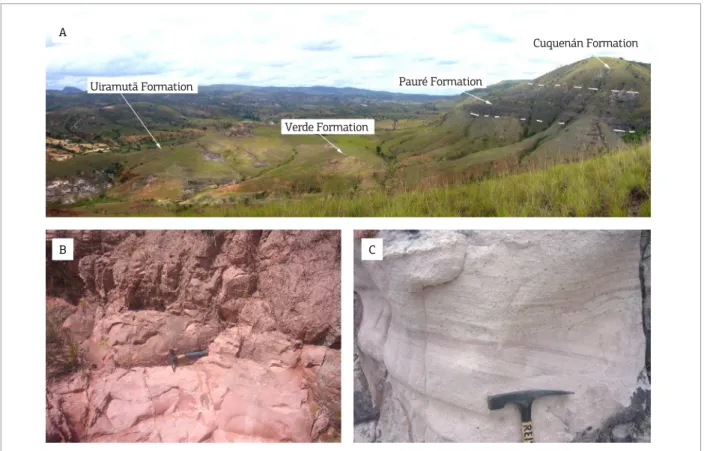
Verde Formation
he Cross Hill area near Uiramutã Village was a good place to deine the sedimentary succession of the Suapi Group (Fig. 12A). Rounded hills and cuestas characterize the landscape. he Verde Formation overlays the Uiramutã Formation in an apparent unconformity and is represented by a rhythmical suc‑ cession of reddish mudstones and siltstones with layers dip of 18o
VENEZUELA
ATLANTIC OCEAN
N
PSB
A B C
E F D G
GUY ANA
SURINAME FRENCHGUIANA
BRAZIL
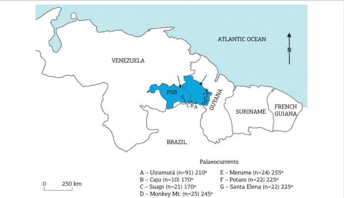
Palaeocurrents A – Uiramutã (n=91) 210º
B – Caju (n=10) 170º C – Suapi (n=21) 170º D – Monkey Mt. (n=25) 245º
E – Merume (n=24) 255º F – Potaro (n=22) 225º G – Santa Elena (n=22) 225º 250 km
0
Figure 11. Arai Formation paleocurrents measurement numbers (n) and associated azimuth (vector of paleolow
Uiramutã Formation
Verde Formation
Pauré Formation
Cuquenán Formation
A
B C
Figure 12. Cross Hill, Uiramutã Village. (A) West of Cross Hill including the four formations of the Suapi Group named Uiramutã, Verde, Pauré and Cuquenán (bottom to top and let to right); (B) ine‑laminated reddish siltstones of the Verde Formation; (C) arkosic sandstones to pebbly sandstones with trough cross‑stratiications present
within the Pauré Formation.
to 12o NE (Fig. 12B). hese ine‑grained rocks show internal
structures of parallel lamination, small‑scale cross‑stratiication, climbing ripples cross lamination and microhummocky struc‑ tures. Castro and Barrocas (1986) had proposed they represent an environment of deposition of an epicontinental sea afected by storm waves (prodelta). Normal grading is characteristic of turbidity‑current deposits in the case of Verde Formation. It corresponds to the Bouma’s C‑D sequence where turbid‑ ites are formed in an upper energy regime and must represent deposition from progressively slower currents (Walker 1984).
he Verde Formation has a thickness of about 50 meters (Reis et al. 1985) and was included into Unit V of Keats (1973). he outcrops of the Formation are well‑preserved in the Brazilian border area, excepted near the border with Venezuela where it occurs as a lat plain topography. To the east towards the Guyanese border it forms high clifs of quartz and arkosic sandstones overlain by the Pauré Formation, which is also overlain by the siltstones of the Cuquenán Formation.
Pauré Formation
he Pauré Formation is composed of a succession of medium to coarse sandstones and pebbly sandstones displaying normal
grading (inning upward) and trough cross‑stratiications of medi‑ um‑size (Fig. 12C). It has been interpreted as a luvio‑deltaic envi‑ ronment where retrogradation event had occurred. Palaeocurrent measurements also point to the SW direction as observed for the Arai Formation. he geomorphology is characterized by a resis‑ tant sandstone layer located between two ine pelitic layers of the upper Cuquenán Formation and the lower Verde Formation, representing a marker unit within the Suapi Group.
to form a wide plain where neotectonic movement led to the erosion and lateritic crust formation of the rocks. In this area the Pedra Preta sill — the second highest level of Avanavero rocks within the Roraima Supergroup disappears laterally and does not extend into Venezuela.
Cuquenán Formation
Greenish‑grey shales intercalated with fine‑grained sandstones and siltstones with prominent parallel lamina‑ tion correspond to the Cuquenán Formation (Reid 1972, Reis & Yánez 2001) which overlies the Pauré Formation. It has been interpreted by Castro and Barrocas (1986) as representing a turbiditic deltaic front with Tdc Bouma cycles. It marks a new transgression phase of the “Verde Sea”. his Formation is cut by the Pedra Preta sill which produced hornfels texture along its contact. It can be cor‑ related to Unit VI of Keats (1973) and mapped in many places of Guyana (e.g. Kowa and Kopinang) where the sill corresponds to the Lower Kopinang Sill.
Along the Brazil–Guyana border the sill extends in an area of low relief in contrast to the high mountains present on the Brazilian side suggesting the sill is thinner along the border (Fig. 13).
Quinô Formation
he type‑area of the Quinô Formation was established in the Upper Quinô River along the border with Venezuela (Bouman 1959). It has been described by Pinheiro et al. (1990) as formed by conglomerates, pebbly sandstones, medium‑ to coarse‑ined sandstones and arkosic sandstones. he Quinô Formation overlies the Cuquenán Formation and the contact is always blanketed by talus deposits in high altitude areas (800 metres above sea level). Medium‑size (less than 1.0 metre) trough cross‑stratiications and tabular cross‑stratiications are the most abundant with palae‑ ocurrent directions of the luvial system to the SW. he top of
the formation is composed of arkosic sandstones forming layers displaying sigmoidal‑shape geometry and palaeocurrent azimuths towards the N, NE and E. Castro and Barrocas (1986) postu‑ lated a luvio‑estuarine environment for the Quinô Formation. he upper sedimentary facies of the Quinô Formation (with sub‑ ordinate shales) constitute a transgressive level with a probable extension into the overlying Uaimapué Formation.
he Quinô Formation can be correlated with Unit VII of Keats (1973) where conglomerates and pebbly sandstones were described in the south of the Pakaraimas, on Tusenen Mountain, near the Kowa River. According to Keats, Unit VII deposition represents a transition (retrogradation) from marine to deltaic environments.
Uaimapué Formation
he interlayered volcaniclastic, volcanogenic and ter‑ rigenous rocks of the Uaimapué Formation represent a lu‑ vial‑deltaic (intertidal, shoreline facies) to shallow marine environment. he formation corresponds to a period of volcanism with aerially transported (reddish to greenish ash fall to ash low acid tufs) and waterlain and/or reworked volcanic ash (tufaceous sandstones) that are penecontem‑ poraneous with continuous sedimentation.
he rocks of the Uaimapué Formation grade from those of the underlying Quinô Formation in terms of its deposi‑ tional environment excepted where the irst layers of vol‑ caniclastic rocks were reworked and/or deposited together with the terrigenous layers to represent the Uaimapué Formation. he rocks of this formation include sandstones, lithic sandstones, quartz sandstones, pebbly sandstones and conglomerates as well as ash fall (so‑called jasper) and ash low tufs, tufaceous sandstones and breccias. he bedding is dipping approximately 5o NE and the maximum thick‑
ness of the Uaimapué Formation was estimated to be about 1,200 metres (Pinheiro et al. 1990). he surface area cov‑ ered by the Uaimapué Formation is larger than the other units of the Roraima Supergroup, extending continuously into Venezuela, Brazil and Guyana (Fig. 14).
According to Reis and Yánez (2001) the Uaimapué Formation is present in two distinct areas on the Brazilian side:
1. Towards Venezuela to the west (Weitepui or Serra do Sol area) where it is dominated by dark tufaceous sand‑ stones and greenish to reddish ash fall tufs containing hummocky cross‑stratiication and mega ripples struc‑ tures. To the top of the unit, the main geometry of the layers are sigmoidal lobes displaying internal trough cross‑stratiication (paleocurrents to the NE).
2. Towards Guyana to the east (Maú/Ireng and Uailã River) where it is dominated by lithic arkosic sandstones, pebbly sandstones and quartz sandstones intercalated with ignimbrites and reddish tufs as observed at Orinduik Falls (Fig. 15). Figure 13. Aerial view of the Guyanese side where broad
hills predominate and altered pyroclasts of the Uaimapué
Figure 14. Aerial view of the natural border represented by the Maú-Ireng River between Brazil and Guyana. The area displayed is of the Uaimapué
Formation composed mainly of reddish tufaceous rocks. The aerial photo was taken a few meters south of Orinduik Falls.
GUYANA
BRAZIL
In the Cipó Mountain of Brazil, opposite to Kopinang Mountain in Guyana, Costi et al. (1988) described pyro‑ clastics layers corresponding to surge deposits which con‑ tain clastic, pumice and acrettionary lapilli fragments. Cipó Mountain was interpreted as a volcanic caldera‑type struc‑ ture (cauldron‑type) including a ring dyke (Cipó Dolerite)
of Avanavero age. Pebbly sandstones with quartz and pyro‑ clastic fragments are possibly associated to fanglomerates (intracaldera facies).
In Guyana Keats (1973) has mentioned a series of quartz sandstone with minor shales overlying Unit VII. In turn, Unit VIII grades continously from Unit VII where the irst layer of tufs or tufaceous sandstones are observed. Based on this observation Units VIII and IX show clear ainities with the Uaimapué Formation in Brazil which is also dominated by pyroclastic lay‑ ers. his author described an environment similar to a more distal facies of a delta front, intertidal, shoreline, mud‑lats, etc. he pyroclastic succession represents a period of volcanism, including airborne, waterlain and reworked materials (volcanogenic).
Matauí Formation
Mount Roraima (2,734 m) represents the sedimentary unit at the top of the Roraima Supergroup named by Reid (1972) as the Matauí Formation. According to this author, the Formation is also found in the Cuquenán, Yuruani, Ayantepuy and Weitepuy mountains in Venezuela. It is a sedimentary rock unit forming the tabletop mountain, at the triple frontier junction of Brazil with Guyana and Venezuela (Fig. 16).
Near the base of Mount Roraima occurs a sill, infor‑ mally named “Mount Roraima” (Reis et al. 1990) and partly covered by coarse colluvium deposit. Tate (1930) described greenish tufs on the sides of the sill, implying its relation to the Uaimapué Formation (Reis & Yánez 2001). In this way, the gentle transition of the Uaimapué sedimen‑ tation to that of the Matauí does not ensure a prolonged timing of deposition between the Formations. here is no ield data yet to support a regional unconformity, and the timing and distribution of the Matauí Formation, as pro‑ posed by Santos et al. (2003), must remain open‑ended.
he Matauí Formation has been described by Pinheiro
et al. (1990) as composed of a succession of ine to very ine arkosic sandstones, medium to coarse arenitic quartz, conglomeratic sandstones and conglomerates. he thickness
Figure 15. Orinduik Falls, Maú/Ireng River at the
border between Brazil and Guyana.
of the Formation was estimated to be approximately 600 meters including the talus material at the base of the mountain. hree main palaeoenvironment of depo‑ sitions of the Matauí Formation were proposed: tidal to shallow marine, aeolian and luvial, although the latter seems to be more appropiate to deine this Formation. It has been considered by various authors to represent two major depositional environments: high energy luvial environment (Reid 1972) and coastal enviroment marked by wave actions (Ghosh 1981). In Guyana, Keats (1973) has not made any attempts to subdivide the Roraima Supergroup above Unit IX.
he Matauí Formation represents the last stage of the Roraima Supergroup deposition cycle, which corresponds to the inal marine regression of the so‑called “Verde Sea” (Reis et al. 1990).
FINAL REMARKS
• he rocks located at the boundary of the Roraima basin suggest an unconformity contact between the Arai Formation and the Surumu/Iwokrama volcanics to the south and with the Transamazonian rocks to the east in Guyana and to the north in Venezuela;
• he stratigraphic integration proposed in this paper based on Reis and Yánez (2001) and Keats (1973) is: the correlation of the Arai Formation with Units I, II, III and IV; the cor‑ relation of the Uiramutã, Verde and Pauré Formations with Unit V; the correlation of the Cuquenán Formation with Unit VI; the correlation of the Quinô Formation with Units VII and VIII; the correlation of the Uaimapué Formation with Unit IX and the correlation of the Matauí Formation
with Unit X. It is proposed to raise the Roraima Group in Guyana to the status of Supergroup;
• here is a lateral correlation of the Roraima Supergroup throughout the Pakaraima Sedimentary Block across the Venezuela‑Brazil‑Guyana boundaries where: he marine sedimentary rocks (e.g., Verde and Cuquenán Formations), the acid pyroclastic beds (Uaimapué Formation), diamond‑rich braided luvial systems (Arai Formation) and the dolerite sills remain as excellent marker of this regional correlation;
• Follow up work is recommended to redeine the Quinô and Uaimapué Formations and their stratigraphic rela‑ tionships in the Roraima Supergroup where it occurs in Brazil, Guyana and Venezuela;
• he Brazil‑Guyana Geological and Geodiversity (land‑use) Mapping Project constituted a great opportunity of geo‑ logical integration in both countries and intensiication of bilateral partnerships. It also represents an important contribution for the Geological Map of South America, in which Brazil is playing the leading role.
ACKNOWLEDGMENTS
The authors acknowledge the financial support of the Brazilian Cooperation Agency (ABC) of the External Relationships Ministry and the Guyanese Government. Also the Amerindian communities for allowing access to areas of their reservations (Karasabai and Raposa‑Serra do Sol). hanks to the ield crews for logistic during the work on both sides of the border. Lastly to the referees for review and comments of the manuscript, in particular to Dr. Mauricio Ibanez‑Mejia (University of Rochester, NY).
Barron C.N. 1986. The Roraima Group Along the Western Frontier of Guyana: an interim report and a discussion of the problems involved. Field Conference, Uiramutã, Roraima Territory, Brazil (not published).
Beyer S.R., Hiatt E.E., Kyser K., Drever G.L., Marlatt J. 2015. Stratigraphy, diagenesis and geological evolution of the Paleoproterozoic Roraima Basin, Guyana: links to tectonic events on the Amazon Craton and assessment for uranium mineralization potential. Precambrian Research, 267:227‑249.
Bouman Q.C. 1959. The Roraima Formation, Northern of Territorio do Rio Branco. Belém, Petrobras/Renor, Relatório Interno 350‑A. 17p.
Briceño H.O., Tapia J., Estanga J. 1989. Formación Ichún. Volcanismo Acido del Grupo Roraima. In: Congresso de Geologia, 7., Caracas.
Memoria... Caracas, p.52‑81.
REFERENCES
Brooks W.E. & Garcia E. 1999. The Carun circular structure – An intact Proterozoic caldera, Estado Bolívar, Venezuela. Geological Society of America, 31(7):A‑178.
Castro J.C. & Barrocas S.L.S. 1986. Fácies e ambientes deposicionais do Grupo Roraima. Rio de Janeiro, Petrobrás/Cenpes, 20p.
Costi H.T., Pinheiro S. da S., Reis N.J. 1988. Rochas Piroclásticas da Formação Uailã, Supergrupo Roraima, Território Federal de Roraima. In: SBG, Congresso Brasileiro de Geologia, 35, Belém,
Anais, 3:1339‑1348.
CPRM. 2016. Programa Geologia do Brasil. Programa Cartograia da
Dreher A.M., Reis N.J., Fraga L.M., Betiollo L.M. 2011. Paleoproterozoic pyroclastic rocks from northern Roraima State, Brazil, Guiana Shield. In: Congreso Latinoamericano de Geología, XIV., Congreso Colombiano de Geologia, XIII., Medellín. Memorias… Medellín, p.243‑244.
Gansser A. 1974. The Roraima Problem (South America).
Verhandlungen der Naturforschenden Gesellschaten in Basel,
84(1):80‑100.
Ghosh S.K. 1981. Geology of the Roraima Group and its Implications.
In: Simposium Amazonico, 1., Puerto Ayacucho, Venezuela.
Memoria…, p.22‑30.
Keats W. 1973. The Roraima Formation Project. 1971‑1973 Final Report. Geological Surveys and Mines Dept., Georgetown, Guyana, Report WK 1/73. 68p.
Long D.G.F. 2002. Aspects of Late Palaeoproterozoic luvial style:
the Uairén Formation, Roraima Supergroup, Venezuela. Special Publication of the International Association of Sedimentologists,
33:323‑338.
Minter L. 2009. Revised Roraima Stratigraphy in Guyana. Deining
Preserved Gold Paleoplacer Surfaces. GGMC, Guyana, Internal Conference. 27p.
Nomade S., Knight K.B., Beutel E., Renne P.R., Verati C., Féraud G., Marzoli A., Youbi N., Bertrand H. 2007. Chronology of the Central Atlantic Magmatic Province: implications for the Central
Atlantic riting processes and the Triassic–Jurassic biotic crisis. Palaeogeography, Palaeoclimatology, Palaeoecology, 244:326‑344.
Pinheiro S.S., Reis N.J., Costi H.T. 1990. Programa Levantamentos Geológicos Básicos do Brasil. Geologia da Região de Caburaí, Nordeste
de Roraima. Escala 1:100.000. Estado de Roraima. DNPM/CPRM.
Superintendência Regional de Manaus, 1v., il. 91p.
Reid A.R. 1972. Stratigraphy of Type Area of the Roraima Group, Venezuela. In: Interguiana Conference Geological, 9., Georgetown, Guyana. Memoria..., p.343‑353.
Reis N.J. 2009. Monte Roraima, RR – Sentinela de Macunaíma.
In: Winge M., Schobbenhaus C., Berbert‑Born M., Queiroz E.T., Campos D.A., Souza C.R.G., Fernandes A.C.S. (Eds.). Sítios Geológicos e Paleontológicos do Brasil. 2. ed. Brasília: CPRM. v.2, p.89‑98.
Reis N.J., Carvalho A.S. 1996. Coberturas sedimentares do Mesoproterozóico do estado de Roraima: avaliação e discussão de seu modo de ocorrência. Revista Brasileira de Geociências, 26(4):217‑226.
Reis N.J., Dreher A., Fraga L.M., Scandolara J.E., Betiollo L. 2009. Serra Tepequém, um possível remanescente de uma caldeira vulcânica paleoproterozóica – Estudos preliminares. In: Simpósio de Geologia da Amazônia, XI., Manaus. Anais... SBG‑Núcleo Norte.
Reis N.J., Faria M.S.G., Fraga L.M.B., Haddad R.C. 2000a. Orosirian Calc‑Alkaline Volcanism and the Orocaima Event in the Northern Amazonian Craton, Eastern Roraima State, Brazil. Revista Brasileira de Geociências, 30(3):380‑383.
Reis N.J., Pinheiro S.S. 2004. A Formação Trincheira – um metalotecto diamantífero no norte do Estado de Roraima. In: Congresso Brasileiro de Geologia, 42., Araxá, MG. Anais... SBG. 1 CD‑ROM.
Reis N.J., Pinheiro S.S., Carvalho J.E. 1985. Subdivisão litoestratigráica
da Formação Suapi – Grupo Roraima, Território Federal de Roraima.
In: Simpósio de Geologia da Amazônia, 2., Belém, Pará. Anais... SBG, p.408‑420.
Reis N.J., Pinheiro S.S., Costi H.T., Costa J.B.S. 1990. A Cobertura Sedimentar Proterozóica Média do Supergrupo Roraima no Norte do Estado de Roraima, Brasil: Atribuições aos seus Sistemas Deposicionais e Esquema Evolutivo da sua Borda Meridional. In: Congresso Brasileiro de Geologia, 36., Natal. Anais... SBG, p.66‑81.
Reis N.J., Pinheiro S.S.; Costi H.T., Souza Cruz C.E. 1988. A Subdivisão do Grupo Suapi no Contexto do Supergrupo Roraima, Porção Setentrional do T.F. de Roraima. In: Congresso Latino‑Americano, 7., Belém, Pará. Anais... SBG, p.389‑398.
Reis N.J., Santos J.O.S., McNaughton N.J., Fletcher I. 2000b. Two distinctive Proterozoic Sedimentary covers in the Northern Amazonian Craton, Roraima State, Brazil. In: International Geological Congress, 31., Rio de Janeiro. Expanded Abstract.
Reis N.J., Teixeira W., Hamilton M.A., Bispo‑Santos F., Almeida M.E.,
D’Agrella‑Filho M.S. 2013. Avanavero Maic Magmatism, a Late
Paleoproterozoic LIP in the Guiana Shield, Amazonian Craton: U– Pb ID‑TIMS baddeleyite, Geochemical and Paleomagnetic Evidence.
Lithos, 174:175‑195.
Reis N.J., Yánez G. 2001. O Supergrupo Roraima ao longo da Faixa Fronteiriça entre Brasil e Venezuela (Santa Elena de Uairén – Monte Roraima). In: Reis N.J., Monteiro M.A.S. (Eds.). Contribuições à Geologia da Amazônia. Manaus: SBG/Núcleo Norte. v.2. p.115‑147.
Santos J.O.S. 1985. A Subdivisão Estratigráica do Grupo Roraima. In: Simpósio de Geologia da Amazônia, 2., Belém, PA. Anais... SBG. p.421‑431.
Santos J.O.S., D’Antona R.J.G. 1984. A Formação Arai e a subdivisão do Grupo Roraima. In: Congresso Brasileiro de Geologia, 33., Rio de Janeiro, RJ. Anais... SBG. p.1162‑1173.
Santos J.O.S., Hartmann L.A., Faria M.S.G., Riker S.R.L., Souza M.M., Almeida M.E., McNaughton N.J. 2006. A compartimentação do Cráton Amazonas em Províncias: avanços ocorridos no período 2000‑2006. In: Simpósio de Geologia, 9., Belém. Resumo Expandido... SBG‑Núcleo Norte. 1 CD‑ROM.
Santos J.O.S., Potter P.E., Reis N.J., Hartmann L.A, Fletcher I.R., McNaughton N.J. 2003. Age, source and Regional Stratigraphy of the Roraima Supergroup and Roraima‑like Sequences in Northern South América, based on U‑Pb Geochronology. Geological Society of America Bulletin, 115(3):331‑348.
Tassinari C.G.C., Macambira M.J.B. 2004. A evolução tectônica do Cráton Amazônico. In: SBG (Ed.). Geologia do Continente Sul‑Americano – Evolução da Obra de Fernando Flávio de Almeida. São Paulo: Ed. Beca. Capítulo XXVIII, p.471‑486.
Tate G.H.H. 1930. Notes on the Mount Roraima region. Geographic Review, 20(1):53‑68.
Walker R.G. 1984. Turbidites and Associated Coarse Clastic Deposits.
In: Walker R.G. (Ed.). Facies Models. 2. ed. Canada: Geoscience Canada Reprint Series 1. p.171‑188.
Wankler F.L. 2001. Caracterização geométrica e arquitetural dos
corpos luviais mesoproterozóicos da Formação Arai (Supergrupo
Roraima), nordeste do Estado de Roraima, Brasil. São Leopoldo, RS. Dissertação de Mestrado, Universidade do Vale dos Sinos, São Leopoldo, 180p.
Wankler F.L., Paim P.S.G., Garcia A.J.V. 2003. Arquitetura deposicional e concentração de minerais pesados na Formação Uiramutã, estado de Roraima, Brasil. In: Paim P.S.G., Faccini U.F., R.G. Netto (Eds.).
Geometria, arquitetura e heterogeneidades de corpos sedimentares – Estudo de casos. FINEP‑Petrobras: São Leopoldo. p.207‑223.
Yánez G.A. 1972. Geología del Área de Santa Elena de Uairén (Mapa de Interpretación de 12.000 km2 en escala 1:250.000). In: Conferencia Geologica Inter‑Guayanas, 9., Ciudad Guayana, Venezuela. Memoria… p.660‑667.
Yánez G.A. 1977. Província Geológica de Roraima, Geología Estructural e Geomorfologia de su parte Suroriental, Venezuela. In: Congresso de Geologia, 5., Caracas, Venezuela. Memoria… p.845‑854.