1Programa de Pós-Graduação em Geociências, Instituto de Geociências, Universidade Estadual de Campinas – UNICAMP, Campinas (SP), Brazil. E-mail: [email protected] 2Departamento de Petrologia e Metalogenia, Instituto de Geociências e Ciências Exatas, Unesp, Rio Claro (SP), Brazil. E-mail: [email protected]
3Departamento de Geologia Aplicada, Instituto de Geociências e Ciências Exatas, Unesp, Rio Claro (SP), Brazil. E-mail: [email protected]
*Corresponding author.
Manuscript ID: 20160144. Received in: 07/22/2016. Approved in: 02/08/2017. ABSTRACT:he Brasília and Ribeira fold belts have been esta‑ blished in south‑southwestern São Francisco Craton during the Brasiliano‑Pan African orogeny (0.9–0.5 Ga – Tonian to Cam‑ brian), and played an important role in West Gondwana continent assembly. he region is given by a complex regional fold and thrust belt superposed by shearing during the orogeny late times, with superposing stress ields forming a structural interference zone. hese thrust sheets encompasses assemblies from lower‑ to upper‑ ‑crust from diferent major tectonic blocks (Paranapanema, São Francisco), and newly created metamorphic rocks. Re‑evaluation of ground gravity datasets in a geologically constrained approach in‑ cluding seismology (CRUST1 model) and magnetic data (EMAG2 model) unveiled details on the deep‑ crust settings, and the overall geometry of the structural interference zone. he Simple Bouguer Anomaly map shows heterogeneous density distribution in the area, highlighting the presence of high‑density, high metamorphic gra‑ de rocks along the Alterosa suture zone in the Socorro‑Guaxupé Nappe, lying amid a series of metasedimentary thrust scales in a regional nappe system with important verticalization along regio‑ nal shear zones. Forward gravity modeling favors interpretations of structural interference up North into Guaxupé Nappe. Compari‑ son to geotectonic models shows similarities with modern accretio‑ nary belts, renewing the discussion.
KEYWORDS: modeling; gravity; magnetics; thrust tectonics; shear zones.
RESUMO:Os cinturões de dobramento Brasília e Ribeira foram estabe‑ lecidos na porção sul‑sudoeste do Cráton São Francisco durante a orogenia Brasiliana‑Pan Africana (0,9–0,5 Ga – Toniano ao Cambriano) e tiveram um importante papel na colagem do continente Gondwana Oeste. A região apresenta um complexo cinturão de dobras e empurrões regionais que foram superpostos por cisalhamento nos termos inais desta orogenia, com atuação de campos de esforço de diferentes orientações e resultando em uma zona de in‑ terferência estrutural. Estas escamas de empurrão compreendem assembleias de crosta inferior a superior de diferentes blocos tectônicos (Paranapanema, São Francisco) e rochas metamóricas geradas durante este evento. A reaval‑ iação de dados de gravimetria terrestre com uma abordagem orientada pelo conhecimento geológico, informação sismológica (modelo CRUST1) e dados magnéticos (modelo EMAG2) revelou detalhes da coniguração da crosta pro‑ funda e a geometria da zona de interferência na região. O mapa de anomalia de Bouguer Simples mostra uma distribuição heterogênea de densidade na área, salientando a presença de rochas de alta densidade e grau metamórico ao longo da zona de sutura de Alterosa, disposta sobre a Nappe de Socor‑ ro‑Guaxupé e entre uma série de escamas de rochas metassedimentares em um sistema de nappes com importante verticalização dos pacotes ao longo das zonas de cisalhamento regionais tardias. Modelos diretos sobre os dados gravi‑ métricos favorecem a interpretação de interferência estrutural até o Norte da nappe de Guaxupé. A comparação com modelos geotectônicos aponta similar‑ idades com cinturões acrecionários modernos e renova a discussão.
PALAVRAS‑CHAVE:modelagem; gravidade; magnetismo; tectônica de empurrão; zonas de cisalhamento.
Geophysical perspective on the structural
interference zone along the Neoproterozoic
Brasília and Ribeira fold belts in West Gondwana
A pespectiva geofísica sobre a zona de interferência
estrutural entre os cinturões de dobramento
neoproterozóicos Brasília e Ribeira no Gondwana Oeste
João Gabriel Motta1*, Norberto Morales2, Walter Malagutti Filho3
INTRODUCTION
Geophysical modeling is an approach to get an insight into Earth’s crust architecture based on indirect infor‑ mation by means of its physical properties, contribu‑ ting to classical structural geology evaluations (Jessell & Valenta 1996, Jessell & Jessell 2001). Gravity mode‑ ling applications are widespread as data are relatively easy to access via public surveys, with well‑established and powerful processing techniques becoming faster and reliable (Nabighian et al. 2005a), also in integra‑ tive interpretation in Global Information Systems and 3D‑modeling suites. The use of geophysics presents a possibility to unveil crust geometry with patterns some‑ times not envisioned just on field observation, such as effects caused by overburden or cryptic structures (Nabighian et al. 2005a,b, Thomas et al. 2008, Stewart & Betts 2010).
he South American platform main crustal growth epi‑ sode took place in the Brasiliano‑Pan African event, spanning from Rodinia breakup in Tonian through West Gondwana (Fig. 1) assembly in Cambrian (Almeida et al. 1981, 2000, Brito Neves & Fuck2013). Neoproterozoic collision and accretion tectonics resulted in a collage of several elements ageing from Archean to Mesoproterozoic due to diachronic basin formation, its deformation and closure (Brito Neves
et al. 1999, Cordani & Sato 1999, Strieder & Suita 1999,
Campos Neto & Caby 2000).
his work provides renewed insight into the geophysi‑ cal framework of the Tocantins and Mantiqueira orogenic systems (Fig. 1) around the Archean São Francisco Craton Southern margin. Its evolution is under discussion since the irst widescale work by Almeida et al. (1981) being successively reappraised (Almeida et al. 2000, Brito Neves
et al. 1999) and recently reviewed on Brito Neves and Fuck
(2013, 2014), highlighting its diverse geo‑chronological inventory. In fact, most information derives from geoche‑ mistry and geochronology in a poorly developed scenario of integrative discussion of structural geology and geophysics. he later counts on contributions by Haralyi and Hasui (1982), Hasui et al. (1993), Mantovani and Brito Neves (2005) and Mantovani et al. (2005) dealing with tectonic elements outline such as cratonic blocks, regional suture zones and fold belts. Although present knowledge on tec‑ tonic and structural development during this orogeny is under construction, several questions remain unanswered, mainly on geochronology and crust geometry — especially in the linking point between the two fold belts, which cons‑ titutes a structural interference zone (Trouw et al. 2013). A point to stress is that the re‑evaluation of previous data, discussed with new evidences from diferent data sources, presents a good opportunity to settle past questions.
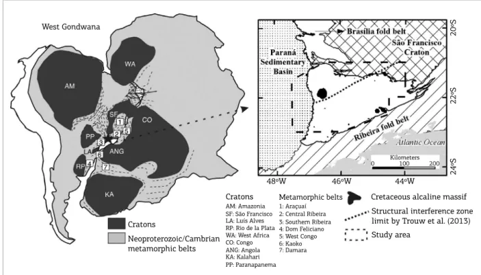
Figure 1. Tectonic elements of West Gondwana (let) and study area (right). Source: let) modiied from Heilbron
et al. (2008), right) according to Bizzi et al. (2001) and Trouw et al. (2013).
West Gondwana
Cratons
Neoproterozoic/Cambrian metamorphic belts
Cratons AM: Amazonia SF: São Francisco LA: Luís Alves RP: Rio de la Plata WA: West Africa CO: Congo ANG: Angola KA: Kalahari PP: Paranapanema
Metamorphic belts 1: Araçuaí
2: Central Ribeira 3: Southern Ribeira 4: Dom Feliciano 5: West Congo 6: Kaoko 7: Damara
Cretaceous alcaline massif
Structural interference zone limit by Trouw et al. (2013) Study area
48ºW 46ºW 44ºW
Kilometers
0 100 200
24ºS
22ºS
Geological framework
he most of the structural framework in Brazilian crust dates back to the Neoproterozoic Brasiliano/Pan‑African event (from 0.9 to 0.5 Ga) represented by Tocantins, Mantiqueira and Borborema orogens and pre‑existing cratons, which under‑ gone various degrees of reworking (Brito Neves & Fuck 2013, 2014). he episodes of sedimentation, reworking, accretion and magmatism throughout the complete geotectonic cycle were diachronic, spanning from Tonian to Early Cambrian with a complex structural evolution (Morales 1993, Brito Neves et al.
1999, Strieder & Suita 1999, Brito Neves & Fuck 2013, 2014). he São Francisco Craton presents tonalite‑trondhjemite‑gra‑ nodiorite gneissic associations, migmatites, and metamor‑ phosed granitoids from Meso‑ to Neo‑Archean, including greenstone belt remnants, being also reworked in its borders during the Brasiliano event with intense shearing (Brito Neves
& Cordani 1991, Teixeira & Figueiredo 1991, Trompette et al.
1992, Romano et al. 2013). Romano et al. (2013) considers the São Francisco craton stabilization age as prior to 2100 Ma.
he Brasília Fold Belt represents Tocantins province southern branch, and is given by metasedimentary and metavolcanic rocks thrusted forward São Francisco Craton western side, meanwhile Ribeira and Araçuaí fold belts are situated in its eastern lank (Almeida et al. 1981, 2000, Brito Neves & Fuck 2013, 2014).
he Brasília Fold Belt comprises a thrust and fold belt pre‑ senting thin‑skin (northern to central segments, 650–610 Ma) and thick‑skin tectonics characteristics (southern portion, up to 530 Ma in age) (Lama et al. 1998, Strieder & Suita 1999, Campos Neto & Caby 2000, Campanha & Brito Neves 2004, Valeriano et al. 2008).
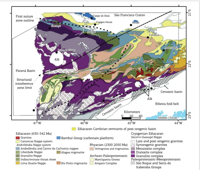
he Southern Brasília belt (Fig. 2) presents a disconti‑ nuous stratigraphy and overlays the reworked São Francisco
Figure 2. Tectono‑stratigraphic units along southern Brasília thrust and fold belt with study area outline (dashed line). Note that ‘alk’ stands for Cretaceous alkaline massifs. Modiied from Trouw et al. (2013). Black dots for
cities, black dashed line for the structural interference zone according to Trouw et al. (2013), long dashed black
line for the suture zone outline by Malagutti Filho et al. (1996) and black continuous outline for the study area.
First suture zone outline
Paraná Basin
Structural interference
zone limit
São Francisco Craton
Alk
Alk
Cenozoic basin
Cenozoic basin
Ribeira fold belt
Kilometers
Ediacaran Cambrian remnants of post-orogenic basin Ediacaran (630–542 Ma)
Granites
Carrancas Nappe system Andrelândia Nappe system
Andrelândia and Carmo da Cachoeira nappes Liberdade Nappe
Granulite Nappe Indiscriminate thrust sheet Lima Duarte Nappe
Bambuí Group (carbonate platform)
Alagoa migmatite
Rio Preto migmatite
Rhyacian (2300 2050 Ma) Orthogneiss and migmatites
Archean-Paleoproterozoic Mantiqueira Gneiss Amparo Complex
Cryogenian Ediacaran Socorro-Guaxupé Nappe
Late and post-orogenic granites Synorogenic granites
Metatexite complex Diatexite complex Granulite complex
Paleoproterozoic-Mesoproterozoic São Roque and Serra do Itaberaba Groups
0 20 40
21°S
22°S
23°S
44°W 45°W
Craton, and is covered itself by the younger Ribeira Fold Belt (590–550 Ma) metasedimentary thrust stacks (Embu and Paraíba do Sul terranes), although a precise limit between Brasília and Ribeira fold belts is still discussed (Heilbron
et al. 2008, Trouw et al. 2013). he metasedimentary nappes
along the intervening fold and thrust belts are interpreted as former oceanic systems that existed along São Francisco and Paranapanema cratons borders since its sedimentary provenience and age relationships are similar, despite debate on thrust stack stratigraphy (Ebert & Hasui 1998, Peternet
et al. 2005, Heilbron et al. 2008, Hasui 2010, Campos
Neto et al. 2011, Trouw et al. 2013, Westin & Campos Neto 2013). Previous structural continuity was obliterated by tight folding and regional branching shear belts from Late‑Neoproterozoic to Cambrian in two regional scale near vertical systems (Ebert & Hasui 1998) — Campo do Meio (mostly E‑W) and Paraíba do Sul (NE‑SW) — due to late‑orogenic lateral adjustments between São Francisco and Congo cratons. he products of this collision and lateral movement, the Socorro‑Guaxupé and Andrelândia nappes, presents low‑angle, southwest dipping nappe stacks super‑ posed with sinistral shear deformation along Campo do Meio Shear Belt (Ebert & Hasui 1998).
Nappe systems tectono‑stratigraphy is given by the rootless Andrelândia Nappe System in the bottom, Carrancas and Lima Duarte Nappe systems in middle levels, including preserved autochthonous sections, and Socorro‑Guaxupé in the uppermost part (Campos Neto
et al. 2011, Trouw et al. 2013). Andrelândia Nappe System
comprises ive thrust slices named in structural upward succession as Lima Duarte, undiferentiated/ indiscrimi‑ nate, granulitic, Liberdade and Andrelândia‑ Carmo da Cachoeira. hey comprise rocks varying from siliceous and chemical metasediments to ortho‑derived meta‑ morphic rocks on greenschist to high‑pressure granulite facies (including eclogites) and migmatites (Alagoa and Rio Preto), juxtaposed by thrust surfaces (Campos Neto
et al. 2007, 2011). Carrancas and Lima Duarte nappe sys‑
tems represent the intermediate‑level thrust sheets, with quartzites, graphite schists, marbles, ultramaic schists and paragneisses up to amphibolite facies, besides it is also found as autochthonous cover over São Francisco Craton (Campos Neto et al. 2011). Socorro‑Guaxupé Nappe comprises an allochthonous lower crust slice, with high pressure/temperature facies metamorphism, given by metatexites, diatexites and granulites with magmatic arc ailiation (~630 Ma) which are older than the meta‑ sedimentary nappes (560 Ma) (Campos Neto & Caby 1999, 2000, Campos Neto et al. 2011).
Expressive sin‑ to post‑orogenic, alkaline to calc‑alkaline, acid magmatism took place on subduction‑related settings
in Paraíba do Sul Shear Belt and Socorro‑Guaxupé Nappe from Criogenian to Ediacarian forming several suites and massifs, being emplaced mainly along shear zones with inhe‑ ritance from Mesoproterozoic basement (Ebert et al. 1996, Sial et al. 1999, Mora et al. 2014).
The Alterosa Suture Zone gives the limit between São Francisco and Paranapanema blocks by the end of the Neoproterozoic, comprising the remainder of the sub‑ duction zone (Malagutti Filho et al. 1996, Ebert & Hasui 1998). he Alterosa Suture Zone trace is given by granu‑ lites from the bottom of Socorro‑Guaxupé Nappe and has been modiied by extensive NE‑SW shear belts (Ebert & Hasui 1998, Campanha & Brito Neves 2004). Eclogites and other lower level crustal rocks are also found in the Andrelândia Nappes System indicating high pressure levels and crust subduction (and therefore, obduction) on the eastern collision front from the Congo Craton, involving middle‑crust thrust slicing from 618–575 Ma (Campos Neto et al. 2011).
he older Amparo Complex and Rhyacian orthogneis‑ ses comprises high grade gneissic rocks with complex tec‑ tonic relationships that occur as slices between the lobes of Socorro‑Guaxupé Nappe, mainly difering from the struc‑ tural settings of the Neoproterozoic units (Heilbron et al.
2008, Valeriano et al. 2008).
he Bambuí Group overlies São Francisco Craton as an extensive low‑ grade to non‑metamorphic mixed‑siliciclas‑ tic and carbonatic Neoproterozoic platformal cover, with minor deformation in the Brasiliano/Pan‑African event (Martins‑Neto 2009).
Geophysical framework
Geophysical approaches to the Southeastern South American platform started in 1980’s engaging on regio‑ nal structural‑geotectonic elements outline (Lesquer et al.
1981, Haralyi & Hasui 1982). From 1990’s to 2000’s eforts gradually focused to more speciic elements in the crust (Hasui et al. 1993, Malagutti Filho et al. 1996, França & Assumpção 2004, Slavec et al. 2004, Mantovani et al. 2005), returning to regional scale works by seismology and poten‑ tial ield methods in the 2010’s (Assumpção et al. 2013a, 2013b, Chulick et al. 2013, Marangoni & Mantovani 2013, van der Meijde et al. 2013, 2015).
Lesquer et al. (1981) presents irst the interpretations over Southern São Francisco Craton geometry, obser‑ ving a NW‑SE Neoproterozoic structural imprint on gra‑ vity data over its Archean grain, suggesting the existence of a WNW‑ESE trending suture zone (Alfenas granulitic belt). Haralyi and Hasui (1982) provided gravity interpre‑ tations of the Archean‑Proterozoic framework in eastern Brazil. hey describe the presence of a (stable) crustal block marked by a very low Bouguer Anomaly, corresponding to São Francisco Craton with crustal thickening, which is sur‑ rounded by higher density belts relating to metamorphic belts with high‑grade elements formed in the Brasiliano‑ Pan Africano event. he authors interpret these higher signal zones as suture zones (Alterosa suture zone) which corres‑ ponds to the Alfenas Granulitic Belt by Lesquer et al. (1981).
Hasui et al. (1993) proceeded into a more detailed asses‑ sment of the crust established during Brasiliano/Pan‑African, outlining diferent orogenic belts, stable entities and regio‑ nal lineaments with more detail, including geochronologi‑ cal evidences, and developing geotectonic reconstructions further into the plate tectonics panorama. Further work by Malagutti Filho et al. (1996) lacks detail into crustal structure along the subduction zone between São Francisco Craton and the Paraná‑Paranapanema Block (Alterosa Suture). heir crustal duplication model depicts the high‑grade granulites being thrust up the São Francisco Craton, with crustal thi‑ ckness varying from 40 to 30 km (thinning to southeast), and including the suture zone displacement along Campo do Meio shear belt. Evidence for the concealed Paraná/ Paranapanema block emerges from gravity processing for the Paraná Sedimentary Basin efect removal (Mantovani
et al. 2005, Mantovani & Brito Neves 2005). heir results
suggests the block outline as a NE‑SW wedge‑like feature that acted as an obducted block in relation to São Francisco Craton, with its exposed roots at Socorro‑Guaxupé Nappe, in agreement to previous interpretations (Malagutti Filho
et al. 1996, Brito Neves et al. 1999).
Estimates for Mohorovičić (Moho) discontinuity depth varies from 34 to 43 km with thicker crust along both
São Francisco craton and Paraná Sedimentary Basin, and thinning over the Neoproterozoic belts and the Atlantic coast (França and Assumpçao 2004; CRUST1 model – 1 degree global crustal model by Laske et al. 2012, Assumpção et al.
2013a, Chulick et al. 2013, van der Meijde et al. 2013). Several crustal thickness and mantle structure models are available proving consistent, besides difering input datasets, constraining parameters, physical property nature, sample density and data distribution (Assumpção et al. 2013b, van der Meijde et al. 2015).
Regarding the Cretaceous alkaline intrusions geophysi‑ cal responses, Marangoni and Mantovani (2013) points out that its emplacement was strongly inluenced by basement and basin structures interpreted on magnetic and gravity data over the N125 mantle‑plume trace azimuth as previou‑ sly envisaged (Ulbrich & Gomes 1981). Gravity modeling estimates for Poços de Caldas alkaline massif depth ranges from 7 to 8 km, with a maximum (17 km) in its center (Slavec et al. 2004).
DATA AND METHODS
Gravity is a quite simple physical property to interpret as it present straightforward relationships in geological contexts relating to density of earth materials, nevertheless, caution is advised for subjectivity and ambiguity issues (La Fehr & Nabighian 2012). Gravity data processing is a well‑established procedure with plenty resourceful descriptions of mathema‑ tical aspects, method revisions and good practices (Blakely 1996, Milligan & Gunn 1997, Nabighian et al. 2005a, La Fehr & Nabighian 2012). Processing and interpretation of magnetics and gravity data follows the potential ield the‑ ory and and are described by relatively similar mathemati‑ cal operations (Blakely 1996).
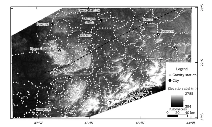
Gravity data used in this contribution are given by 1214 ground stations from Universidade de São Paulo
(USP) Instituto de Astronomia, Geofísica e Ciências
Atmosféricas (São Paulo – Brazil) database acquired
with varying station spacing from 8 to 20 km (Fig. 3). The dataset comprises surveys back to 1960’s and inclu‑ des data from Malagutti Filho et al. (1996). These data are stored in tables with location for each station, gra‑ vity measurements and its reduced form by International Union of Geodesy and Geophysics 1967 gravity formula and values for Simple Bouguer anomaly (2670 kg.m‑3
layers integration on ESRI Arc Map™ GIS system for comparison to geological data.
Earth Magnetic Anomaly 2‑arc min grid (EMAG2, Maus et al. 2009) accounts for a magnetic data compi‑ lation collected around the globe by diferent platforms, mainly ground, satellite and airborne, integrated into a 2 arc‑minute resolution surface referenced 4 km above the geoid, and containing long wavelength information (>330 km) from satellite data. he interpretation of the magnetic geophysical method has been reviewed in Blakely (1996) and Nabighian et al. (2005b).hese data are useful for deep crust magnetic structure observation, displayed for comparison to the features observed on geology, gra‑ vity and crustal thickness data. EMAG2 data are hosted in GMT (Wessel & Smith, 2013) software‑compatible gridded surfaces for visualization. CRUST1 model (Laske
et al. 2012), data comprises point information on crus‑
tal thickness (Moho‑depth) determinations by seismo‑ logy studies for a world‑wide model from several sources (active, passive, long and short‑term stations). hese data were interpolated into 1‑degree cell size surfaces with the minimum curvature algorithm (Briggs 1974). he discus‑ sion of the development of both EMAG2 and CRUST1 models is not intended in this contribution and reader should refer to the mentioned publications.
Preliminary observation of the gravity dataset showed presence of high‑frequency noise over some data stations. Its analysis with the Power spectrum method (Spector & Grant 1970) in a gridded surface allowed identiication of spurious high‑frequency noise. he spurious data have been suppressed through Nyquist frequency removal by low‑pass iltering with 0.06‑cycle frequency cut‑of, resulting in the Simple Bouguer Anomaly map refered from here onwards as Bouguer Anomaly (Fig. 4). his map presents smooth con‑ tours, being absent of local high amplitude artifacts.
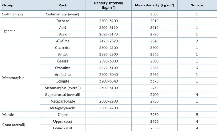
Two and a half dimensional modeling took place in Geosoft’s Oasis Montaj GM‑SYS platform over information on the Simple Bouguer anomaly map (Fig. 4) being cons‑ trained by geology information based on a geological map by Trouw et al. (2013) (Fig. 2) and interpretations as previou‑ sly exposed in the geological framework section. Data from CRUST1 model were used to constrain Moho discontinuity depth. hree geological sections (Fig. 4) have been modeled with reference density information from compilations by Carmichael (1989), Telford et al. (1990) and Turcotte and Schubert (2002) and a paper by Slavec et al. (2004) – see details in Table 1. GM‑SYS forward modeling platform is an iterative environment for potential ield data modeling which complies with Talwani et al. (1959) and Won and Bevis (1987) proposals for anomaly calculation.
Figure 3. Gravity data station location over SRTM digital elevation model. Black dashed line for the structural interference zone according to Trouw et al. (2013).
Gravity station City
Legend
Elevation absl (m)
47ºW 46ºW 45ºW 44ºW 23ºS
22ºS
21
ºS
0 20
394 2785
GRAVITY RESULTS
Results comprise qualitative interpretations over Bouguer Anomaly maps and forward models in the following sections unveiling the geometry of the struc‑ tural interference zone.
Bouguer anomaly maps
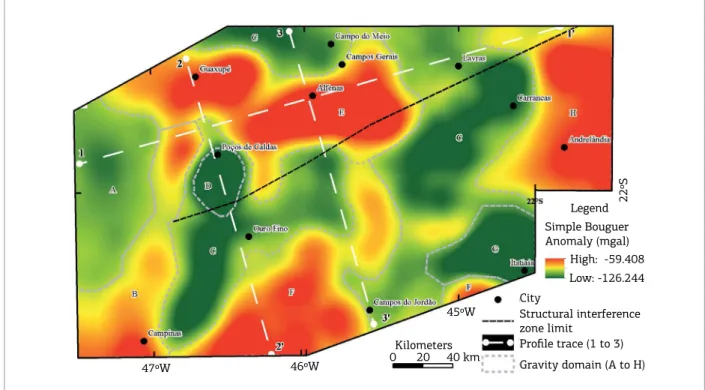
The Bouguer Anomaly (Fig. 4) varies from ‑125.8 to ‑59.6 mGal in the area, showing complex outlines due to diferent density assemblages and the superposition of the structural grains. Gravity domains trends NE‑SW, NW‑SE and N‑S similar to mapped geology, despite an immediate relationship is not straightforward, with regions overlapping diferent tectonic elements. he results are discussed in terms of its possible geological counterpart according to the geological background map (Fig. 2) by Trouw et al. (2013).
Higher Bouguer anomaly values in the area are up to ‑59 mGal and occurs in wide, E‑W to roughly NE‑SW trending features in the central part part of the study area (domains E and F, Fig. 4) interpreted as high‑ to medium‑ grade metamorphics such as the Socorro‑Guaxupé Nappe granulites amidst relatively less dense areas (domain C, Fig. 4). Other higher Bouguer anomaly regions along Paraná Sedimentary Basin border are considered as basic rocks
(domain B, Fig. 4), or high grade nappes over São Francisco Craton or greenstone belt associations (domain H, Fig. 4).
Gravity Domain C is given by values lower than ‑90 mGal trending NE‑SW to NNE‑SSW and E‑W directions cor‑ responding to lat‑lying do medium‑angle, lower grade meta‑sedimentary rocks from Andrelândia and Carrancas nappe systems and Lima Duarte Nappe, also ortho‑derived lower crust from Socorro‑Guaxupé nappe, including syn‑ to post‑tectonic granitic bodies. Amphibolite facies Rhyacian orthogneiss‑ migmatite complexes and Archean gneisses from Amparo Complex and Mantiqueira Gneiss compri‑ ses this domain, with low Bouguer anomaly values along Ribeira do Sul shear belt further southeast.
Bouguer anomaly domains with values less than ‑95 mGal, and circular to oval outlines (domains D and G, Fig. 4) relates to Cretaceous alkaline massifs, respectively Poços de Caldas and Itatiaia‑ Passa Quatro. hese gravity domains reaches the minimum values observed (‑125.87 mGal) and its response is given by its lower density relative to a denser basement.
he domains with higher values in Bouguer Anomaly (E and F) shows gentle signal attenuation according to the expected dip of the thrust sheets, with the signal attenua‑ ting to the SW in E and to the SE in F. In domain C there is not clear evidence for the dip of the rock packages, with high gradients in NE‑SW directions, suggesting that they
Table 1. Density values for the rock unities in the modeled sections.
Group Rock Density interval
(kg.m‑³) Mean density (kg.m‑³) Source
Sedimentary Sedimentary (mean) 2500 1
Igneous
Diabase 2500–3200 2910 1
Acid 2300–3110 2610 1
Basic 2090–3170 2790 1
Alkaline 2470–2620 2545 2
Metamorphic
Quartzite 2500–2700 2600 1
Schist 2390–2900 2640 1
Gneiss 2590–3000 2800 1
Granulite 2670–3100 2885 3
Anfibolite 2900–3040 2960 1
Eclogite 3200–3540 3370 1
Metamorphic (overall) 2400–3100 2740 1
Supracrustal (overall) 2700 4
Metacarbonate 2600–2900 2750 1
Metagraywacke 2600–2700 2650 1
Mantle Upper 3250 5
Crust (overall) Upper crust 2730 4
Lower crust 2850 4
have near‑vertical geometry, which is evidenced by geo‑ logical information regarding its position centered in the shear belt system.
Two gravity domains with Simple Bouguer Anomaly ranging from ‑95.0 to ‑80 mGal occur in the western lank of the area relates to Paraná Sedimentary Basin (A and B, Fig. 4). Domain A represents a region of thicker sedimen‑ tary section (from basal Itararé Group to the Pirambóia Formation) underlain by basic volcanics, meanwhile Domain B complies with a thinner sedimentary pile and preponderant response from the basic rocks in Serra Geral Formation. An alternative for the higher gravity values in domain B is the presence of relatively shallow high‑grade basement near to the basin border. he latter hypothesis seems feasible as the B domain extends from the basin to the North‑Northeast into the Neoproterozoic metamorphic basement.
Considering Bouguer Anomaly along the structural interference zone, domains C, E and F gives informa‑ tion as follows:
■ domain E (fig. 4) presents anomaly values up to ‑59.6 mGal in a E‑W trend representing granulitic rocks from Guaxupé Nappe, juxtaposed to Andrelândia Nappe System granulite‑facies metamorphic rocks along Campo do Meio shear belt. Similar to E domain, F domain presents higher values; however, it presents a NE‑SW trend, interpreted as granulite‑facies meta‑ morphic rocks from Socorro Nappe;
■ a set of NE‑SW gravity lows occurs along C domain (Fig. 4) trending parallel to Paraíba do Sul shear belt and the structural interference zone limit proposed by Ebert and Hasui (1998) and Trouw et al. (2013), being considered as expression of highly‑deformed/stretched metasedimentary rock packages;
■ connecting E and F domains exists a relatively higher density zone trending N‑S, varying from ‑90 to ‑80 mGal without surface expression of expectedly relatively denser rock types, being interpreted as rocks akin to Socorro and Guaxupé nappe lobes amid the intense shearing.
Forward models
Forward modeling took place on three sections along the nappe system main trace (section 1, Fig. 5) and also ortho‑ gonal to regional shear belts (sections 2 and 3, Figs. 6 and 7) to depict the two structural patterns.
Despite that gravity data processing did not focused Moho depth determination, the gravity long wavelength signal/forms (regional ield) complies with a 37 to 43 km seismic‑mode‑ led Moho, (CRUST1 and other models). his interface is deeper to the West beneath Paraná Basin and thins to East and Southeast in a sharp step close to São Francisco Craton. Models also shows a Moho surface given by wide arcuate seg‑ ments with local pinch‑up points beneath the Neoproterozoic fold and shear belt, contrasting with a linear outline bellow the Archean craton (Figs. 5 and 6).
Figure 4. Bouguer Anomaly map and gravity domains in this study (dashed black lines) and modeled sections trace (dashed white lines, from 1 to 3).
Simple Bouguer Anomaly (mgal)
High: -59.408 Legend
Low: -126.244 City
Structural interference zone limit
Gravity domain (A to H)
Profile trace (1 to 3)
47ºW 46ºW
45ºW
22ºS
Figure 6. Forward model 2‑2’ orthogonal to the shearing system and fold and thrust belt (see igure 4 for model location). Gravity domain limits are marked in lower level. Vertical exaggeration is 0.8.
Depth (km)
Bouguer Anomaly (mgal)
-80
2
-96
-112
-128 0
32
64
Misfit
Misfit: 3.0
Calculated gravity
Observed gravity
Andrelândia nappe
(d: 2640 kg.m-3)
São Francisco craton
(d: 2800 kg.m-3)
Alterosa suture zone
Liberdade nappe
(d: 2640 kg.m-3)
Cretaceous alkaline
(d: 2545 kg.m-3)
Rhyacian metamorphics
(d: 2800 kg.m-3)
Amparo complex
(d: 2800 kg.m-3)
Indiscriminate thrust sheet
(d: 2640 kg.m -3) Syn-orogenic granitoids
(d: 2610 kg.m-3)
Domain E C D C F
2´
Metatexite
(d: 2800 kg.m-3)
Granulitic complex
(d: 2885 kg.m-3) Lower crust
(d: 2850 kg.m-3) Mantle
(d: 3250 kg.m-3)
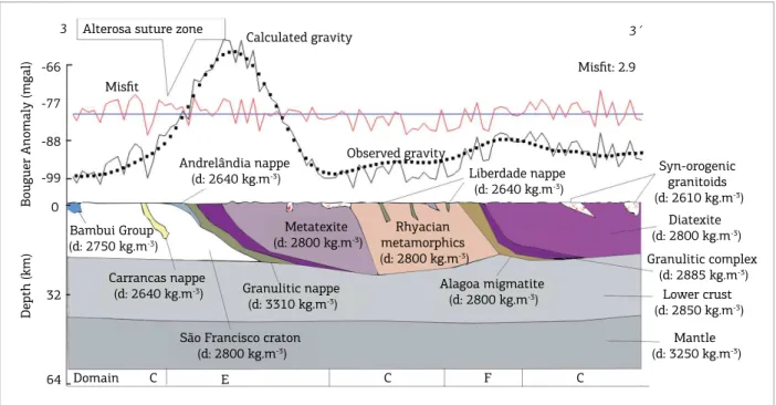
The first order structural trace is given by discon‑ tinuous, medium‑ to low‑ angle thrust sheets over São Francisco Craton (sections 1 and 3, Figs. 5 and 7). hese thrust sheets presents lat‑lying geometry with internal stack truncation, as well as rootless and folded sheets, like Andrelândia and Carrancas nappe systems (proiles 2 and 3, Figs. 6 and 7). Steepening of the thrust stacks along the Late‑Neoproterozoic shear zones afects the tectonic pile from basement to the uppermost nappes, including stack
truncation and afecting the Rhyacian orthogneisses and migmatites, without signiicant imprint in São Francisco Craton (Figs. 6 and 7).
Granulite‑diatexite‑metatexite lower crust associations occurs as thick low‑angle nappe stacks (proiles 1 to 3, Figs. 5 to 7) representing the higher density domains (E and F) on Bouguer anomaly maps, with a disconti‑ nuous outline. hese lower crust stacks are part of Alterosa Suture zone (Figs. 5 to 7), which is juxtaposed to upper
Figure 5. Forward model 1‑1’ along the thrust system over São Francisco Craton (see igure 4 for model location). Gravity domain limits are marked in lower level. Vertical exaggeration is 0.5.
Depth (km)
Bouguer Anomaly (mgal)
-70
-80
-90
-100
0
1
32
64
Misfit
Misfit: 3.3
Paraná Basin
(d: 2500 kg.m -3)
Diatexite
(d: 2800 kg.m-3)
G. domain
Syn-orogenic
granitoids (d: 2610 kg.m-3)
Metatexite
(d: 2800 kg.m-3)
Granulitic complex (d: 2885 kg.m-3)
Granulitic nappe (d: 3310 kg.m-3)
Andrelândia nappe (d: 2640 kg.m-3) Bambui Group (d: 2750 kg.m-3)
São Francisco craton (d: 2800 kg.m-3)
Lower crust (d: 2850 kg.m-3)
Mantle (d: 3250 kg.m-3)
Alterosa suture zone
Observed graviy Calculated gravity
1´
level meta‑sedimentary and meta‑volcanic thrust sheets from Andrelândia nappe system, and above the Guaxupé Nappe granulite slice. he granulitic nappes in proiles 1 and 3 (Figs. 5 and 7) are assigned density 3310 kg.m‑3
for being described as containing eclogite levels as well. Deformation along the shear belt incorporates older gneisses amid the nappe system, causing displacement and block isolation in an intricate array along Paraíba do Sul shear belt central displacement zone (e.g. Amparo Complex, Alagoa migmatite and Rhyacian gneisses, Figs. 6 and 7).
São Francisco craton was modeled as a straight to sli‑ ghtly curved block bellow the Neoproterozoic fold and thrust belts (Figs. 5 and 7) in a lat ramp‑like geometry, with crust duplication of overriding lower crust nappes from Socorro Guaxupé nappe on high‑grade gneisses from its infrastructure (Figs. 5 to 7).
Syn‑ to post‑ tectonic granites occur amid thrust sheets with bounding surfaces following thrust stacks limits, secon‑ dary thrust surfaces and shear zones, including rootless bodies (Figs. 5 and 6), hosted along past higher permeability and stress relief zones.
Paraná sedimentary basin occurs as a thin cover (Fig. 5, west lank), being modeled with a 2500 kg.m‑3 density, with
increasing thickness to the West according to overall basin geology (Zalan et al. 1990) emplaced over high‑grade asso‑ ciations from Guaxupé Nappe.
Poços de Caldas Cretaceous alkaline massifs appears on section 2, shaped as an voluminous irregular circular‑ like
body and its geometry is dubious in absence of constrai‑ ning evidence.
DISCUSSION
Discussion on the crustal framework and structural interference response on geophysical data follows gravity interpretations in the light of current geological models, including comparison to previous information, data from CRUST1 and EMAG2 models, and geotectonic models.
Gravity and crustal framework
Power spectrum analysis results are in the range of crustal thickness calculated via other methods, being shallower (24 km) than estimates in CRUST1 model ranging from 37 to 42 km, similar to other independent studies (França & Assumpção 2004, Assumpção et al.
2013a, Chulick et al. 2013, van der Meijde et al. 2013). Concerning the crust stabilization age (Durrheim and Mooney 1991, 1994) the Moho depth for the crust formed in Archean‑ and Proterozoic‑ ranges from 32 to 45 km on the irst, and 42 to 55 km in the second. Overall lower Moho depth values are observed in the area in compari‑ son to these reference values. São Francisco Craton crustal thickness on forward models is up to 30 km, which is inferior to mean values for crust stabilized from 2.5 to 2.6 Ga (Abbott et al., 2013).
Figure 7. Forward model 3‑3’ along the thrust system over São Francisco Craton (see igure 4 for model location). Gravity domain limits are marked in lower level. Vertical exaggeration is 0.8.
Depth (km)
Bouguer Anomaly (mgal)
-66
-77
-88
-99
0
32
64
Misfit
Misfit: 2.9
Alterosa suture zone
Calculated gravity
Andrelândia nappe
(d: 2640 kg.m-3)
Bambui Group
(d: 2750 kg.m-3)
Carrancas nappe
(d: 2640 kg.m-3)
São Francisco craton
(d: 2800 kg.m-3)
Metatexite
(d: 2800 kg.m-3)
Granulitic nappe
(d: 3310 kg.m-3)
Observed gravity
Rhyacian metamorphics
(d: 2800 kg.m-3)
Liberdade nappe
(d: 2640 kg.m-3)
Alagoa migmatite
(d: 2800 kg.m-3)
3´
Domain C E C F C
3
Syn-orogenic granitoids
(d: 2610 kg.m-3) Diatexite
(d: 2800 kg.m-3) Granulitic complex
(d: 2885 kg.m-3) Lower crust
(d: 2850 kg.m-3)
Mantle
Figure 8. Gravity domains over the tectonic framework (in colors) by Almeida et al. (1981) and Bizzi et al. (2000),
Alterosa suture zone proposed outlines and shear‑related features.
Gravity domains (from A to H)
Tectonic framework
Regional shear zones and fold axis according to Ebert and Hasui (1998)
Structural interference zone limit by Trouw et al. (2013)
Alterosa suture outline (this work) Alterosa suture outline by Malagutti Filho et al. (1996) 47ºW
A
46ºW
45ºW
22ºS
44ºW
0 20
Kilometers 40 km Ribeira fold belt
he overall trace of the geophysical domains is compa‑ tible to the structural trace in shear zones and axial zones of major folds (Fig. 8). Gravity domains E and F relates to Alterosa Suture (Fig. 8) as an discontinuous high‑density crust fragment taken as the limit for Brasília fold belt and São Francisco Craton (Alkmim et al. 1993, Malagutti Filho
et al. 1996), and displaced by the sinistral‑ motion of Paraíba
do Sul shear belt by the end of the Neoproterozoic (Ebert & Hasui 1998). he link between the domains E and F, and, moreover, the Alterosa Suture are missing amid the shear system. he models constructed here indicate that Alterosa suture zone traces needs re‑observation due to its structu‑ ral position just below the granulite sets (bellow domains E and F). For suggesting the new outline of the Alterosa suture zone we followed the boundaries of domains E (Guaxupé Nappe) and F (Socorro Nappe). We are aware that the scale of the gravity survey and lithology maps used in our interpretation, also the density contrast of the litho‑ logies, can difer from mapped surface geology. his suture trace is given by geophysical information and has been cons‑ trained by geological facts as long as possible.
A crustal duplex structure along the lower crust nappes and upper nappes has been proposed previously by Haralyi and Hasui (1982) and following works by Valeriano et al.
(2008), Hasui (2010) and Campos Neto et al. (2011) with
geochemistry constraints for deep crust involvement (Campos Neto & Caby 1999, Iyer et al. 1996, Lama et al. 1998). Complex geometries for both thrust‑folding and shear systems observed in forward models, structural and metamorphism features are expected in a continuum crustal model for orogen evolution (Boyer & Elliott 1982, Sanderson 1984, Sylvester 1988). Syn‑ to late‑ orogenic granite bodies and massifs pre‑ sents shallow roots along thrust and shear‑related surfaces, conirming its relation to local magma generation and empla‑ cement during orogeny late‑ stages (Ebert et al. 1996, Sial
et al. 1999, Mora et al. 2014). Relationships to the diferent
crustal levels observed and tentatively modeled in the gra‑ vity datasets are further discussed in the following section.
Survey spacing, potential ield ambiguity, source body shape and superposition, along with poor density contrast are probably involved in absence of clear geophysical sig‑ natures for tectonic elements, except for high‑grade meta‑ morphic rocks and Cretaceous alkaline massifs.
Deep geophysical expression of
the structural interference zone
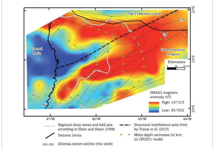
Figure 9. Structural and geophysical elements around Alterosa suture zone region.
EMAG2 magnetic anomaly (nT)
High: 147.513
Low: 83.7052
Regional shear zones and fold axis according to Ebert and Hasui (1998)
Tectonic limits
Alterosa suture outline (this work)
Structural interference zone limit by Trouw et al. (2013)
Moho depth estimates (in km) on CRUST1 model
47ºW 46ºW 45ºW 44ºW
23ºS
22ºS
Kilometers
21
ºS
0 20 40 km
he discontinuous Alterosa Suture outline previously deined by Malagutti Filho et al. (1996) was redeined, with the new outline presented being situated near a crustal thin‑ ning region in crustal thickness maps, following the trace of the Moho depth contours (Fig. 9). he relationship to crustal thickness suggests that late‑Neoproterozoic evolution included deeper crust re‑organization or that such level of reconstruction was already established. Cenozoic alkaline magmatism could account for this discrete thinning in São Francisco Craton border but needs supporting information. he discontinuity in the trace of the suture zone along with the interference zone conirms that the lateral structural system is post‑ kinematic in relation to the suturing event. EMAG2 data magnetic grain shows high‑magnetiza‑ tion areas according to regional low‑angle thrust surfaces direction and to the high‑angle shear systems main trace as presented by Ebert and Hasui (1998) (Fig. 9). he wed‑ ge‑like continuous high magnetization zone follows the nappe system outline, with decreasing signal to the sou‑ thwest (into the Paraná Sedimentary Basin) and extending further northeast into the São Francisco Craton with sub‑ dued signal. he magnetic response in the Paraná Basin is given by extreme lower values and into the Neoproterozoic
regions in a cuspid shape, also beneath the Poços de Caldas alkaline massif.
Interestingly, the magnetic grain near the proposed suture zone trace (Fig. 9) is given by gentle signal decay to the SW in the Guaxupé Nappe lobe, suggesting a dip to that direction, as also argued from structural evidences, the gra‑ vity anomaly and the gravity models. For the Socorro lobe things are not that straightforward, with a general resem‑ blance from the magnetic outline to the suture line, with more pronounced gradients in the magnetic anomaly, sug‑ gesting a dip angle not so gentle as in Guaxupé, probably due to the major inluence of the Paraíba do Sul Shear Belt and the structural interference zone.
It is noteworthy that the structural interference zone limit proposed by Trouw et al. (2013) fairly centers on the high magnetization wedge‑like zone, suggesting that the deve‑ loping the structural interference zone did not altered its magnetic properties by giving a magnetic signature by itself. his relies on the fact that the EMAG2 model in the area is given mainly by satellite information, representing long‑wa‑ velength information – so it depicts deep crust.
relates to poor magnetic contrast between the two high‑grade terrains, as they comprise exposed lower crust sections commonly with high magnetization and long‑wavelength signal (Shive et al.
1992). hese long wavelength characteristics are products of deep‑seated continental roots with its common maic nature, rich in magnetic minerals, also Moho, upper‑lower crust and Curie interface undulations, or higher metamorphic grade of deeply‑ eroded crust (Shive et al. 1992).
he new trace for the Alterosa suture is more confor‑ mable to the gravity, magnetic and Moho depth infor‑ mation, and has been conceived with geologic cons‑ traints, difering from the outline by Malagutti Filho
et al. (1996). It also has a clear oblique geometry to the
structural interference zone limit deined by Trouw et al.
(2013) (Fig. 9). Regarding EMAG2 information a total match from the trace of the features mapped in gravity and surface geology is reasonably unexpectable given the satellite nature of the magnetic information, and presents deep crust information which implies a possible misma‑ tch regarding dipping structures.
To deine a precise structural interference zone limit by geophysical methods is challenging as it concerns a complex structural framework with weak density contrast between entities. Surface information suggests that structural inter‑ ference goes further North over Socorro‑Guaxupé Nappe (Peternel et al. 2005, Trouw et al. 2013), which is suppor‑ ted by gravity data as Alterosa suture discontinuity is fairly coincident with the proposed structural interference zone limit marked by Três Corações shear zone on Paraíba do Sul shear belt (Malagutti Filho et al. 1996, Ebert & Hasui 1998).
Insights into geotectonic models
Debate over crust‑ mantle interactions and its linkage to orogenesis since Archean has poor evidence for lower crust development (Windley & Tarney 1986, Percival et al. 1992). However, present models on mantle thermal evolution and mass transfer points out to a dynamic scenario from early Earth to nowadays tectonics with diferent evolution of colli‑ sional systems along time, markedly post‑ Proterozoic orogens (Cawood et al. 2009, Abbott et al. 2013, Gerya 2014, Jamieson & Beaumont 2013, Kamber 2015). Lower‑ and upper‑ crust sections juxtaposition by thrust systems supports its evolution by thick‑skinned tectonics style (Coward 1983). his contrasts to the observation that thrust systems are common in orogens involving shallower crust conditions (thin‑skinned tectonics) as observed on Brasilia Fold Belt further north from study area (Simões 1995, Strieder & Suita 1999, Valeriano et al. 2008). Collision tectonics models supports late‑ colisional continental block adjustment in large‑scale shear belts, overprinting prior structural grain (Cawood et al. 2009, Gerya 2014, Jamieson & Beaumont 2013).
Large scale, late‑ collisional shearing on Brasília and Ribeira fold belts during lateral/oblique tectonics stages included high pressure granulites extrusion (Ebert & Hasui 1998, Campos Neto & Caby 2000, Lama et al. 2000) with nappe stacks being cut by near‑vertical shear zones. his is a well‑documented feature in linked strike‑slip and thrust tec‑ tonics systems (Woodcock & Fischer 1986, Coward 1994, Davison 1994, Woodcock & Schubert 1994). Late‑stage shearing evolution contrasts to pure fold and thrust systems proposals (Campos Neto & Caby 2000, Campanha & Brito Neves 2004, Campos Neto et al. 2011, Trouw et al. 2013), not accounting for the remarkable large scale Campo do Meio and Paraíba do Sul shear belts oblique motion, a fact previously discussed by Ebert and Hasui (1998).
Comparing the study area based on a geodynamic model for accretionary orogens by Jamieson and Beaumont (2013) shows similarity with large‑hot orogen systems, with distinct periods of crustal material accretion involving sutures, alter‑ nating with stages of thrusting of deep crust plutonic and high grade metamorphic rocks. According to the author’s Prowedge/Retrowedge/Uplifted plug/subduction Conduit (P‑U‑R‑C) systematics, Brasília and Ribeira fold belts lies between São Francisco, and Paranapanema cratons and rela‑ ted African cratons (Congo) ‑ similar to a PUR system, as follows. he closure of the former ocean took place with the fragment containing the Prowedge (P) overriding plate forming thrust stacks (Ediacaran to lower crust ultra‑high pressure Cryogenian nappe systems) and an internal and less deformed Retrowedge (R) with its subduction Conduit (C) far from the collision front, probably not outcropping today. In‑between P and R segments lies an extruded biver‑ gent Uplifted plug (U) of highly deformed, upper and lower crust nappes with the meta‑ sediments from the former oce‑ anic(?) basins and interlayered granitoid bodies and extru‑ ded granulites. Late‑ stage Early Cambrian tectonics took place with PUR assemblage deformation by Paraíba do Sul and Campo do Meio shear belts including granitic magma intrusion along structural surfaces, with ongoing sin‑ to post tectonic granitic magmatism. Nowadays deep erosion levels (probably) precludes entire large‑ hot orogen system recog‑ nition by suppression of uppermost orogen architecture, as well as most of Uplifted plug and Retrowedge being mos‑ tly buried bellow Paraná Sedimentary Basin and demands further investigation.
CONCLUDING REMARKS
Abbott D.H., Mooney W.D., VanTongeren J.A. 2013. The character of the Moho and lower crust within Archean cratons and the
tectonic implications. Tectonophysics, 609:690-705. doi: 10.1016/j.
tecto.2013.09.014
Alkmim F.F., Brito Neves B.B., Alves J.A. 1993. Arcabouço tectônico
do Cráton do São Francisco - uma revisão. In: Simpósio sobre o Cráton
do São Francisco e suas Faixas Marginais, Salvador. p. 72-77.
Almeida F.F.M., Brito Neves B.B., Dal Ré Carneiro C. 2000. The origin
and evolution of the South American Platform. Earth-Science
Review, 50:77-111. doi: 10.1016/S0012-8252(99)00072-0
Almeida F.F.M., Hasui Y., Brito Neves B.B., Fuck R. A. 1981. Brazilian structural provinces: an introduction. Earth-Science Review, 17:1-29. doi: 10.1016/0012-8252(81)90003-9
Assumpção M., Bianchi M., Julià J., Dias F.L., Sand França G., Nascimento R., Drouet S., Pavão C.G., Albuquerque D.F., Lopes A.E.V. 2013a. Crustal thickness map of Brazil: Data compilation and main
features. Journal of South American Earth Sciences, 43:74-85. doi:
10.1016/j.jsames.2012.12.009
REFERENCES
Assumpção M., Feng M., Tassara A., Julià J., 2013b. Models of crustal thickness for South America from seismic refraction, receiver
functions and surface wave tomography. Tectonophysics, 609:82-96.
doi: 10.1016/j.tecto.2012.11.014
Blakely R.J. 1996. Potential theory in gravity and magnetic
applications. Cambridge University Press, Cambridge.
Bizzi, L.A., Schobbenhaus, C., Vidotti, R.M., Gonçalves, J.H., 2003. Geologia, Tectônica e Recursos Minerais do Brasil: texto, mapas e SIG. CPRM, Brasília.
Boyer S.E., Elliott D. 1982. Thrust systems. American Association of
Petroleum Geologists Bulletin, 66:1196-1230.
Briggs I.C. 1974. Machine contouring using minimum curvature.
Geophysics, 39:39-48.
Brito Neves B., Cordani U. 1991. Tectonic evolution of South America
during the late Proterozoic. Precambrian Research, 53:23-40. doi:
10.1016/0301-9268(91)90004-T
assessment, although Alterosa suture outline in southeast‑ to east regions still demands further scrutiny with ield informa‑ tion and alternative geophysical approaches. Models propo‑ sed here also favors previously envisaged late‑stage shearing tectonic models (Morales 1993, Ebert & Hasui 1998), see‑ mingly extendable to deeper levels (Boyer & Elliott 1982, Sanderson 1984, Sylvester 1988). Shear‑related structures superposes the low‑lying to medium‑ inclined thrust stacks and controls syn‑ to late‑tectonic granitic bodies emplace‑ ment (Ebert et al. 1996, Ebert & Hasui 1998, Mora et al.
2014). he extension of the structural interference zone pro‑ posed by Trouw et al. (2013) stands conirmed by geophysi‑ cal means, also observations by Campanha and Brito Neves (2004) are somewhat in agreement regarding the thrust sys‑ tem formation, and the oblique kinematics for its formation. hrust stacks are extended to deep levels and external/ independent information is necessary to reduce subjecti‑ vity and ambiguity inherent to the gravity interpretation (Skeels 1947, Jessell & Jessell 2001). Gravity itself does not address entirely the structural complexity and joint inter‑ pretation. he CRUST1 model presents evidence for crus‑ tal‑ scale structure along the fold and thrust system limit along São Francisco Craton south/south‑western edge with similar interpretation on EMAG2 data. Since complete understanding is far from complete, our proposed analogue model for accretion‑related evolution takes the syntax zone as the product of a two‑fold event, accounting for late‑she‑ aring structural imprint. his analogue model takes basis in Jamieson and Beaumont (2013) PURC systematic for
accretion since Proterozoic times (at least) in disagreement to pure fold and thrust belt proposals (Campos Neto et al.
2011, Trouw et al. 2013).
From the geophysical perspective the outline of the Alterosa Suture zone still demands further scrutiny allied by ield work and, maybe, by other geophysical surveys. his work presents an alternative to current views and stands to be proven by information other than geophysics – relying in the supportive nature of the geophysical datasets – absent of trueness by itself.
ACKNOWLEDGEMENTS
JGM is thankful to Conselho Nacional de Desenvolvimento
Científico e Tecnológico (CNPq) ‑ “National Counsel of
Technological and Scientiic Development” inancial support during its time as Master’ student in Programa de pós‑gra‑
duação em Geociências e Meio Ambiente (Graduate school
Brito Neves B.B., da Costa Campos Neto M., Fuck R. A. 1999. From Rodinia to western Gondwana: an approach to the Brasiliano-Pan
African cycle and orogenic collage. Episodes, 22:155-166.
Brito Neves B.B., Fuck R.A. 2013. Neoproterozoic evolution of the
basement of the South-American platform. Journal of South American
Earth Sciences, 47:72-89. doi: 10.1016/j.jsames.2013.04.005
Brito Neves B.B., Fuck R.A. 2014. The basement of the South American platform: Half Laurentian (N-NW) + half Gondwanan
(E-SE) domains. Precambrian Research, 244:75-86. doi: 10.1016/j.
precamres.2013.09.020
Campanha G.A.C., Brito Neves B.B. 2004. Frontal and Oblique Tectonics in the Brazilian Shield. Episodes, 27(4):255-259. Available from: <https://www.researchgate.net/publication/279595384_ Frontal_and_oblique_tectonics_in_the_Brazilian_shield>
Campos Neto M.D.C., Basei M.A.S., Assis Janasi V., Moraes R. 2011. Orogen migration and tectonic setting of the Andrelândia Nappe system: an Ediacaran western Gondwana collage, south of São
Francisco craton. Journal of South American Earth Sciences,
32:393-406. doi: 10.1016/j.jsames.2011.02.006
Campos Neto M.D.C., Caby R. 1999. Neoproterozoic high-pressure metamorphism and tectonic constraint from the nappe system
south of the Sao Francisco Craton, southeast Brazil. Precambrian
Research, 97:3-26. doi: 10.1016/S0301-9268(99)00010-8
Campos Neto M.D.C., Caby R. 2000. Terrane accretion and upward extrusion of high-pressure granulites in the neoproterozoic nappes
of Southeast Brazil: Petrologic and structural constraints. Tectonics,
19:669-687. doi: 10.1029/1999TC900065
Campos Neto M.D.C., Janasi V.A., Basei M.A.S., Siga Jr. O. 2007.
Sistema de nappes Andrelândia, setor oriental : litoestratigraia e posição estratigráica. Revista Brasileira de Geociências, 37:47-60.
Carmichael R. 1989. Physical properties of rocks and minerals.
Florida, CRC Press Inc.
Cawood P.A., Kroner A., Collins W.J., Kusky T.M., Mooney W.D., Windley B.F. 2009. Accretionary orogens through Earth history.
Geological Society of London, 318:1-36. doi: 10.1144/SP318.1
Chulick G.S., Detweiler S., Mooney W.D. 2013. Seismic structure of the crust and uppermost mantle of South America and surrounding
oceanic basins. Journal of South American Earth Sciences,
42:260-276. doi: 10.1016/j.jsames.2012.06.002
Cordani U.G., Sato K. 1999. Crustal evolution of the South American Platform, based on Nd isotopic systematics on granitoid rocks.
Episodes, 22:167-173.
Coward M. 1983. Thrust tectonics, thin skinned or thick skinned, and
the continuation of thrusts to deep in the crust. Journal of Structural
Geology, 5:113-125. doi: 10.1016/0191-8141(83)90037-8
Coward M. 1994. Continental collision. In: Hancock P.L. (Ed.).
Continental Deformation. Oxford, Pergamon Press Ltd., p. 264-288.
Davison I. 1994. Linked fault systems: extensional, strike slip
and contractional. In: Hancock, P.L. (Ed.). Continental Deformation.
Oxford, Pergamon Press Ltd., p. 121-142.
Durrheim R.J., Mooney W.D. 1991. Archean and Proterozoic crustal
evolution: evidence from crustal seismology. Geology, 19:606-609.
Durrheim R.J., Mooney W.D. 1994. Evolution of the Precambrian
lithosphere: Seismological and geochemical constraints. Journal of
Geophysical Research, 99:15359-15374. doi: 10.1029/94JB00138
Ebert H.D., Chemale Jr. F., Babinski M., Artur A.C., van Schmus W.R. 1996. Tectonic setting and U/Pb zircon dating of the plutonic Socorro Complex in the Transpressive Rio Paraíba do Sul shear belt, SE Brazil. Tectonics, 15:688-699.
Ebert H.D., Hasui Y. 1998. Transpressional tectonics and strain partitioning during oblique collision between three plates in the Precambrian of southeast Brazil. Geological Society of London,
135:231-252. doi: 10.1144/GSL.SP.1998.135.01.15
França G.S., Assumpção M. 2004. Crustal structure of the Ribeira
fold belt, SE Brazil, derived from receiver functions. Journal of
South American Earth Sciences, 16:743-758. doi: 10.1016/j.
jsames.2003.12.002
Gerya T. 2014. Precambrian geodynamics: Concepts and models.
Gondwana Research, 25:442-463. doi: 10.1016/j.gr.2012.11.008
Granot R., Dyment J. 2015. The Cretaceous opening of the South
Atlantic Ocean. Earth and Planetary Science Letters, 414:156-163.
doi: 10.1016/j.epsl.2015.01.015
Guimarães S.N.P., Ravat D., Hamza V.M. 2014. Combined use of
the centroid and matched iltering spectral magnetic methods
in determining thermomagnetic characteristics of the crust
in the structural provinces of Central Brazil. Tectonophysics,
624‑625:87-99. doi: 10.1016/j.tecto.2014.01.025
Haralyi N.L.E., Hasui Y. 1982. The gravimetric information and the
Archean-Proterozoic structural framework of eastern Brazil. Revista
Brasileira de Geociências, 12:160-166.
Hasui Y. 2010. A grande colisão pré-cambriana do sudeste brasileiro e a estruturação regional. Geociências, 29:141-169.
Hasui Y., Haralyi N.L.E., Costa J.B.S. 1993. Megaestruturação pré-cambriana do território brasileiro baseada em dados geofísicos e geológicos. Geociências, 12:7-31.
Heilbron M., Valeriano C.M., Tassinari C.C.G., Almeida
J., Tupinamba M., Siga O., Trouw R. 2008. Correlation of
Neoproterozoic terranes between the Ribeira Belt, SE Brazil and its African counterpart: comparative tectonic evolution and
open questions. Geological Society of London, 294:211-237. doi:
10.1144/SP294.12
Iyer S.S., Choudhuri A., Pattison D.R.M., De Paoli G.R. 1996. Petrology and geochemistry of the Neoproterozoic Guaxupé granulite
facies terrain, southeastern Brazil. Precambrian Research, 77. doi:
10.1016/0301-9268(95)00043-7
Jamieson R.A., Beaumont C. 2013. On the origin of orogens.
Bulletin of Geological Society of America, 125:1671-1702.
doi: 10.1130/B30855.1
Jessell M., Jessell M. Geophysics K., Geophysics K., 2001.
Three‑dimensional geological modelling of potential ield data.
Computers & Geosciences, 27:455-465.
Jessell M.W., Valenta R.K. 1996. Structural geophysics:
Integrated structural and geophysical modelling. Computer
Methods in the Geosciences, 15:303-324. doi: 10.1016/
S1874-561X(96)80027-7
Kamber B.S. 2015. The evolving nature of terrestrial crust from the
Hadean, through the Archaean, into the Proterozoic. Precambrian
Research, 258:48-82. doi: 10.1016/j.precamres.2014.12.007
La Fehr T.R., Nabighian M.N. 2012. Fundamentals of gravity
exploration. Tulsa, Society of Exploration Geophysicists.
Lama E.A., Oliveira M.A.F., Zanardo A. 1998. Geochemistry of the
Guaxupé Granulites, Minas Gerais, Brazil. Gondwana Research,
1:357-365. doi: 10.1016/S1342-937X(05)70851-0
Lama E.A., Zanardo A., Oliveira M.A.F., Morales N. 2000. Exhumation of high-pressure granulites of the Guaxupé complex, southeastern Brazil. Geological Journal, 35:231-249. doi: 10.1002/gj.859
Laske G., Masters G., Ma Z., Pasyanos M.E. 2012. CRUST1. 0 : an
Lesquer A., Almeida F.F.M., Davino A., Lachaud J.C., Maillard P. 1981.
Signiication structurale des anomalies gravimetriques de la partie
Sud du Craton de São Francisco (Bresil). Tectonics, 76:273-293.
Malagutti Filho W., Ebert H.D., Hasui Y., Haralyi N.L.E., Hackspacher P.C., Sturaro J.R., Souza C.A., Almeida S.H.S. 1996. Gravimetria e
compartimentação crustal no sul de Minas Gerais. Geociências,
15:199-217.
Mantovani M.S.M., Brito Neves B.B. 2005. The Paranapanema lithospheric block: Its importance for Proterozoic (Rodinia,
Gondwana) supercontinent theories. Gondwana Research,
8:303-315. doi: 10.1016/S1342-937X(05)71137-0
Mantovani M.S.M., Quintas M.C.L., Shukowsky W., Neves B. 2005. Delimitation of the Paranapanema proterozoic block: A geophysical contribution. Episodes, 28:18-22.
Marangoni Y.R., Mantovani M.S.M. 2013. Geophysical signatures of
the alkaline intrusions bordering the Paraná Basin. Journal of South
American Earth Sciences, 41:83-98. doi: 10.1016/j.jsames.2012.08.004
Martins-Neto M. A. 2009. Sequence stratigraphic framework of
Proterozoic successions in eastern Brazil. Marine and Petroleum
Geology, 26:163-176. doi: 10.1016/j.marpetgeo.2007.10.001
Maus S., Barckhausen U., Berkenbosch H., Bournas N., Brozena J., Childers V., Dostaler F., Fairhead J.D., Finn C., Von Frese R.R.B., Gaina C., Golynsky S., Kucks R., Lühr H., Milligan P., Mogren S., Müller R.D., Olesen O., Pilkington M., Saltus R., Schreckenberger B., Thébault E., Tontini F.C. 2009. EMAG2: A 2-arc min resolution Earth Magnetic Anomaly Grid compiled from satellite, airborne, and marine magnetic measurements.
Geochemistry, Geophysics, Geosystems, 10. doi: 10.1029/2009GC002471
Milligan P., Gunn P.J. 1997. Enhancement and presentation of
airborne geophysical data. AGSO Journal of Australian Geology &
Geophysics, 17:63-75.
Mora C.A.S., Campos Neto M.D.C., Basei M.A.S. 2014. Syn-collisional lower continental crust anatexis in the Neoproterozoic Socorro-Guaxupé Nappe System, southern Brasília Orogen, Brazil: Constraints from zircon U–Pb dating, Sr–Nd–Hf signatures and
whole-rock geochemistry. Precambrian Research, 255:847-864. doi:
10.1016/j.precamres.2014.10.017
Morales N. 1993. Evolução tectônica do cinturão de cisalhamento Campo
do Meio na sua porção ocidental. São Paulo, University of São Paulo.
Nabighian M.N., Ander M.E., Grauch V.J.S., Hansen R.O., LaFehr T.R., Li Y., Pearson W.C., Peirce J.W., Phillips J.D., Ruder M.E. 2005a. Historical
development of the gravity method in exploration. Geophysics,
70:63ND-89ND. doi: 10.1190/1.2133785
Nabighian M.N., Grauch V.J.S., Hansen R.O., LaFehr T.R., Li Y., Peirce J.W., Phillips J.D., Ruder M.E. 2005b. The historical development of
the magnetic method in exploration. Geophysics,70:33ND-61ND.
doi: 10.1190/1.2133784
Peate D. 1997. The Paraná-Etendeka Province. Geophysical
Monograph. 100:217-246.
Percival J.A., Fountain D.M., Salisbury M.H. 1992. Exposed crustal
cross sections as windows on the lower crust. In: Fountain D.M.,
Arculus R., Kay R.W. (Eds.), Continental Lower Crust (Developments in
Geotectonics 23). Amsterdam, Elsevier, p. 317-362.
Peternel R., Allard R., Trouw J., Da R., Schmitt S. 2005. Interferência entre duas Faixas Móveis Neoproterozóicas : o caso das faixas Brasília
e Ribeira no Sudeste do Brasil. Revista Brasileira de Geociências,
35:297-310. doi: 10.5327/rbg.v35i3.1170
Romano R., Lana C., Alkmim F.F., Stevens G., Armstrong R. 2013. Stabilization of the southern portion of the São Francisco craton, SE
Brazil, through a long-lived period of potassic magmatism. Precambrian
Research, 224:143-159. doi: 10.1016/j.precamres.2012.09.002
Sanderson D. 1984. Transpression. Journal of Structural Geology,
6:449-458. doi: 10.1016/0191-8141(84)90058-0
Shive P.N., Blakely R.J., Frost B.R., Fountain D.M. 1992. Magnetic
properties of the lower continental crust. In: Fountain D.M., Arculus
R., Kay R.W. (Eds.), Continental Lower Crust (Developments in
Geotectonics 23). Amsterdam, Elsevier, p. 145-177.
Sial A.N., Dall’Agnol R., Ferreira V.P., Nardi L.V.S., Pimentel M.M.,
Wiedemann C.M. 1999. Precambrian granitic magmatism in Brazil.
Episodes, 22:191-198.
Simões L.S.A. 1995. Evolução tectonometamórica da Nappe de Passos,
sudeste de Minas Gerais. São Paulo, Universidade de São Paulo.
Skeels D.C. 1947. Ambiguity in gravity interpretation. Geophysics,
12:43-56. doi: 10.1190/1.1437295
Slavec G.D.B., Mantovani M.S.M., Shukowsky W. 2004. Estudo gravimétrico do Maciço Alcalino de Poços de Caldas - Minas
Gerais. Revista Brasileira de Geociências, 22:88. doi: 10.1590/
S0102-261X2004000100009
Spector A., Grant F.S. 1970. Statistical models for interpreting
aeromagnetic data. Geophysics, 35:293-302.
Stampli G.M., Hochard C., Vérard C., Wilhem C., von Raumer J. 2013.
The formation of Pangea. Tectonophysics, 593:1-19. doi: 10.1016/j.
tecto.2013.02.037
Stewart J.R., Betts P.G. 2010. Implications for Proterozoic plate margin evolution from geophysical analysis and crustal-scale modeling
within the western Gawler Craton, Australia. Tectonophysics,
483:151-177. doi: 10.1016/j.tecto.2009.11.016
Strieder A.J., Suita M.T.D.F. 1999. Neoproterozoic geotectonic evolution of Tocantins Structural Province, Central Brazil.
Journal of Geodynamics, 28:267-289. doi: 10.1016/
S0264-3707(98)00042-8
Sylvester A.G. 1988. Strike-slip faults. Geology Society of America
Bulletin, 100:1666-1703.
Talwani M., Worzel J.L., Landisman M. 1959. Rapid gravity computations for two-dimensional bodies with application to
the Mendocino submarine fracture zone. Journal of Geophysical
Research, 64:49-59. doi: 10.1029/JZ064i001p00049
Teixeira W., Figueiredo M.C.H. 1991. An outline of Early Proterozoic crustal evolution in the São Francisco craton,
Brazil: a review. Precambrian Research, 53:1-22. doi:
10.1016/0301-9268(91)90003-S
Telford W.M., Geldart L.P., Sherif R.E. 1990. Applied Geophysics, 2nd
edition. Cambridge, Cambridge University Press.
Thomas J.L., Direen N.G., Hand M. 2008. Blind orogen: Integrated appraisal of multiple episodes of Mesoproterozoic deformation and reworking in the Fowler Domain, western Gawler Craton,
Australia. Precambrian Research, 166:263-282. doi: 10.1016/j.
precamres.2007.05.006
Trompette R.R., Uhlein A., Egydio-Silva M., Karmann I. 1992. The Brasiliano São Francisco craton revisited (central Brazil).
Journal of South American Earth Sciences, 6:49-57. doi:
10.1016/0895-9811(92)90016-R
Trouw R.J., Peternel R., Ribeiro A., Heilbron M., Vinagre R.,
Dules P., Trouw C.C., Fontainha M., Kussama H.H. 2013. A new
interpretation for the interference zone between the southern
Brasília belt and the central Ribeira belt, SE Brazil. Journal
of South American Earth Sciences, 48:43-57. doi: 10.1016/j.
jsames.2013.07.012
Turcotte D.L., Schubert G. 2002. Geodynamics, 2nd edition.
Ulbrich H.H.G.J., Gomes C.B. 1981. Alkaline rocks from continental Brazil.
Earth-Science Review, 17:135-154. doi: 10.1016/0012-8252(81)90009-X
Valeriano C.M., Pimentel M.M., Heilbron M., Almeida J.C.H., Trouw
R.J. 2008. Tectonic evolution of the Brasilia Belt, Central Brazil,
and early assembly of Gondwana. Geology Society of London,
294:197-210. doi: 10.1144/SP294.11
van der Meijde M., Fadel I., Ditmar P., Hamayun M. 2015. Uncertainties in crustal thickness models for data sparse
environments: A review for South America and Africa. Journal of
Geodynamics, 84:1-18. doi: 10.1016/j.jog.2014.09.013
van der Meijde M., Julià J., Assumpção M. 2013. Gravity derived Moho
for South America. Tectonophysics, 609:456-467. doi: 10.1016/j.
tecto.2013.03.023
Wessel P., Smith W.H.F. 2013. Generic Mapping Tools: Improved
version released. EOS Trans. AGU, 94:409-410.
Westin A., Campos Neto M.D.C. 2013. Provenance and tectonic setting
of the external nappe of the Southern Brasília Orogen. Journal of South
American Earth Sciences, 48:220-239. doi: 10.1016/j.jsames.2013.08.006
Windley B.F., Tarney J. 1986. The structural evolution of the lower crust of orogenic belts, present and past.
Geological Society of London, 24:221-230. doi: 10.1144/GSL.
SP.1986.024.01.20
Won I.J., Bevis M. 1987. Computing the gravitational and magnetic anomalies due to a polygon: Algorithm and Fortran subroutines.
Geophysics, 52:232-238.
Woodcock N.H., Fischer M. 1986. Strike-slip duplexes. Journal of
Structural Geology, 8:725-735. doi: 10.1016/0191-8141(86)90021-0
Woodcock N.H., Schubert C. 1994. Continental strike-slip tectonics.
In: Hancock P.L. (Ed.), Continental deformation. Oxford, Pergamum
Press Ltd., p. 251-264.
Zalan P.V., Wolf S., Astoli M.A.M., Vieira I.S., Conceição J.C.J., Appi
V.T., Santos Neto E.V., Cerqueira J.R., Marques A. 1990. The Parana
Basin, Brazil: Chapter 33: Part II. Selected Analog Interior Cratonic
Basins: Analog Basins, 134:681-708.