2001 Published by Elsevier Science Ltd. Pergamon
Printed in Great Britain 0264-2751/01 $ - see front matter www.elsevier.com/locate/cities
PII: S0264-2751(01)00030-0
Unbridled Development of Urban
Space and its Implications for the
Preservation of Landmarks
The Morro da Queimada Archaeological Site,
Ouro Preto, Brazil
Marco Fonseca, Frederico Sobreira, M. Estela Rainho and
Marcus Oliveira*
Department of Geology, Federal University of Ouro Preto, Campus Universita´rio, Morro do Cruzeiro S/N — 35400-000 — Ouro Preto, MG, Brazil
The process of expansion of urban centers in Brazil has been distinguished by the complete absence of planning. As a result, urban environments lead to land uses encroaching on, defacing and destroying landmarks. Attention is given to the Morro da Queimada Archaelogical Site. This represents an important cultural heritage of the 1720 movement of secession during the gold rush. Several ruins of mining equipments such as houses, wells, shafts and galleries have been gradually destroyed. The process of the site’s loss of distinct character has been monitored since 1950 using aerial photographs and cartography. Collected data indicate a conservative annual land-use change rate of about 1.5%. This rate points to the complete destruction of the site in 2008. This paper proposes the creation of the Morro da Queimada Historical Park, within the limits of the remaining set of ruins.2001 Published by Elsevier Science Ltd.
Introduction
The lack of planning that characterizes urban centers in Latin America, especially related to the process of expansion, is one of the chronic problems that has affected various Brazilian cities to a lesser or greater extent. Owing to various factors, this process of unplanned settlement began in Brazil at the end of the 1950s, and evolved in different ways in different regions. This evolution is controlled by socio-econ-omic and political factors. At the end of the 20th cen-tury, it came to be a challenge for public officials, and is in large part responsible for the urban chaos that can be seen in many Brazilian cities.
In a general sense, this process may be con-veniently considered to be an anthropogenic disturb-ance because it causes a series of environmental
prob-*Corresponding author. Tel.: +55-31-3559-1600; fax: + 55-31-3559-1605; e-mail: [email protected]
lems such as pollution of the underground water table due to the complete absence of sewage systems and surperficial waste exposures that pollute the surface waters.
According to the Brazilian Institute of Geography and Statistics, 53% of the total population lived in urban areas in 1970. This rate increased very quickly, reaching 81% in 2000. It is important to point out that annual population growth rate decreased, for the same period, from 3% in the 1970s to 1.6% in 2000. The data clearly indicate that the migration process is in the main responsible for the saturation of Brazilian cities. The new urban inhabitants are generally low-income and the migration process reflects a search for better living conditions.
of a great number of Brazilian citizens. As a conse-quence, the worst results of this process are poor qual-ity of life due to the “slummification” of neighbor-hoods without adequate infrastructure and appropriate public areas, and the exposure of inhabitants to natu-ral hazards such as floods and landslides. The cruelty of this process may most clearly be seen in the extent to which Brazilian citizens are subjected to unsafe liv-ing conditions, which are systematically ignored by public officials.
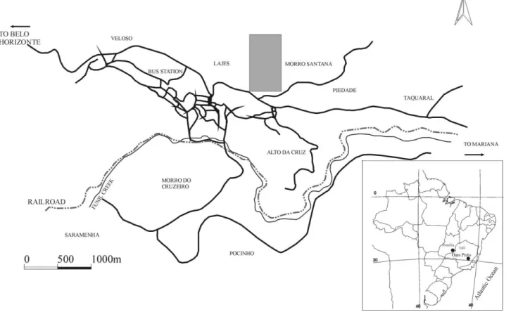
The city of Ouro Preto, Latin America’s most acclaimed landmark (Fig. 1) is an example of this pro-cess of unplanned settlement with its attendant prob-lems. It is a city of 45,000 inhabitants in which this situation has been aggravated as a result of the extremely irregular topography that characterizes the entire urban area, the unfavorable geotectonic aspects of the bedrock and successive human interventions in the physiography of the area.
This paper will address an aspect occurring as a result of this process: the consequent defacement and ensuing destruction of landmarks and historical sites. Specifically, it will draw attention to the case of Morro da Queimada or Arraial de Ouro Podre. This area constitutes the original urban center that later became the Arraial de Vila Rica (presently called Ouro Preto). After a brief diagnosis of urban occu-pation in Ouro Preto, this paper will analyze the pro-cess that has been taking place in the aforementioned
Figure 1 Ouro Preto urban zone. The Morro da Queimada site is indicated by the shaded rectangle
area. The historical basis for the preservation of this area will also be offered as well as a proposal for the creation of a Historical Park that will preserve the existing archaeological material. In addition, it will serve to emphasize the importance of gold mining in the 18th century and the social turmoil of 1720, which has, in large part, remained ignored by Brazilian society.
Diagnosis of the problem of urban
settlement in Ouro Preto
The historical city of Ouro Preto has its origins in the discovery of gold at the end of the 17th century. The city achieved its apogee in political, economic and historical terms at the end of the 18th century. Gold mining was the basis of its economy during this per-iod. The intense search for gold affected the entire region in which the city is located today, especially the Ouro Preto range, the northern portion of the present day urban area. According to the Fundac¸a˜o Joa˜o Pinheiro (1975), the local population during the period was approximately 150,000, not counting slaves, who had as their principal function the mining of gold.
excavations that are found throughout the area. The mining process entailed the construction of under-ground openings and wells, which usually followed mineralized veins. The process also involved the extraction of gold from iron formations that existed in nearly the entire range, from Ouro Preto to Mariana. Consequently, in many areas located in the Ouro Preto range, gold mining activities substantially alt-ered the landscape and the original hydrological regime. These activities destabilized the soil and accelerated the process of evolution of the slopes. The rearrangement of such a large volume of material, the diverting of natural drainage and the excavation of innumerable galleries and wells constituted the princi-pal practices of the period.
After the gold had been exhausted, economic and political decline set in, the population had declined, and, as result, these areas had been abandoned, human intervention ceased, and a certain balance was achi-eved. Thus, the process of evolution of slopes came to be influenced only by natural agents. Although these alterations in the area had accelerated this evolution, it may be assumed that the evolution of slopes in the Ouro Preto range did not have a direct anthropic con-tribution at least until the beginning of the 1970s. Nonetheless, there remain throughout the range vari-ous structures of earlier mining. At that time, the min-ing processes were rudimentary and did not take into account any technical planning, including geological and engineering concerns. Horizontal and inclined galleries were opened to reach the mineralized veins without any topographic control, thus forming real labyrinths, trying to follow the ore body. Shafts were excavated without care for safety, just being enough for just one person to get in. One of the main prob-lems of mining at that time concerned water. Water was important to separate gold from the ore. Mining on the tops of hills was then subject to water supply. One of the mechanisms developed to store water was the building of small dams known as mundeo. The
mundeo was a small circular or square reservoir, up
to 10 m in diameter and 3–4 m deep, made up of rock blocks, joined together by means of sand and mortar. Themundeoswere built in isolation or in series down-hill. In its front wall, there is a narrow chink closed by a wood table that allows a controlled flow of water. Despite the lack of geological knowledge to support a technical mining operation, a series of sub-horizontal channels (about 1–3% declivity) were dug along the hills at different topographic levels and up to 4 km in lateral extension in order to provide water to fill the mundeos.
The ruins, galleries, wells, channels,mundeos and excavations are of inestimable archaeological, histori-cal and cultural value and may highlight the history of mining in Portuguese America during the 17th cen-tury. This heritage — neither surveyed nor studied — remains unknown, despite its cultural and scientific value. Additionally, the ruins present a great potential for the tourism industry. One set of ruins can be seen
in present-day neighborhoods such as Veloso, Pied-ade, Alto da Cruz and Morro da Queimada. The latter neighborhood contains a large number of ruins and structures that represent a rich and controversial per-iod in Brazilian history.
Beginning in the 1970s the problems of unplanned development that occurred to varying degrees as a result of growing urbanization in many parts of Brazil also affected Ouro Preto. The recent land use, there-fore, is a second-generation process that interferes with the balance that the scarps had achieved and gen-erates various risk factors. The unplanned settlement also poses problems for the city’s heritage. Most of the city’s heritage and geological landmarks have been destroyed or altered by new construction and are nearly impossible to recover or restore. The lack of public policies regulating the use of urban areas allowed most low-income individuals to use those former mining areas, which, in turn, created an impact on several historical sites.
There have been attempts to plan land-use in Ouro Preto during the past 25 years. The first one was worked out by Fundac¸a˜o Joa˜o Pinheiro in 1975 but this plan gave attention just to the historical down-town, focusing on the architectural heritage and ways to improve civil and religious structural preservation. In 1982, with an agreement of the City Hall, the Fed-eral University of Ouro Preto and The National Sec-retary of Cultural Heritage, a Geotechnical Map of the urban area was produced at scale 1:2000. This map was the most important document to provide a land-use policy in the city, but not all its suggestions and regulations could be applied due to the lack of a legal basis to their applications.
The second attempt undertaken by the City Hall in 1989. Unfortunately, due to political problems, this plan could not be concluded either (Sobreira, 1992a). In 1996, a new plan was developed by the City Hall, which encompassed a broader view of the problem, taking into account the encroaching process along the hills around the city. This plan also proposed an urban zoning based on physiographic, urban and architec-tural aspects. However, just like the others, most suggestions and policies were not applied due the lack of a legal basis.
Morro da Queimada historical background
(Vasconcellos, 1904; Veiga, 1897). The leaders of the rebellion were mostly affluent Portuguese nationals who opposed the crown colonial policies in Minas Gerais and the ways in which the Count of Assumar administered the province. The leader of the move-ment was Paschoal da Silva Guimara˜es, one of the richest local miners, the owner of the majority of businesses related to trade, and owner of a large num-ber of slaves.
This historical episode, known as the Vila Rica sedition, highlights the Morro da Queimada’s role as one of the oldest historical sites in Ouro Preto. It also emphasizes its importance as a point of reference for future studies in the history and archaeology of 18th century mining.
The destruction of the historical site of
Morro da Queimada (1950–1998)
Similar to other places with ruins and remains of enormous historical and cultural value in the Ouro Preto, the Morro da Queimada site has been gradually destroyed. The Morro da Queimada’s ruins are scat-tered in a 250,000-m2 area that has not been deeply
affected by mining activity. According to preliminary research, this area potentially has rich archaeological material that is essential for the reconstruction of the mining history in the region. However, large parts of the original area of Morro da Queimada were used and many of its ruins were destroyed in the process of preparing the terrain for new construction. Areas that had been previously “recomposed” were also util-ized as either foundations or parts of new houses, and the rocks that were part of the ruins were “recycled” as construction material. In the majority of the cases this sort of human intervention has permanently dam-aged the area’s heritage and historical sites. Nonethe-less, this process is advancing towards yet other struc-tures, and, judging by the present-day situation, very soon houses will take over the whole area.
Establishing the original boundaries or limits of the Morro da Queimada site is a difficult task. A count-less series of walls, houses and ruins, as well as gal-leries and shafts, are scattered along the Ouro Preto range between the present urban nucleus and the Pass-agem de Mariana village. It is not known whether the whole set of ruins is of about the same age as the original Morro da Queimada site, or if some of them had been built later. Most of them are, however,
con-Table 1
Monitoring interval Total used area Use % Time interval (y) Anual land use Total land use
(sq m) rate % rate %
1950-69 10,800 4,3% 19 0,22 0,22
1969-86 65,700 26,3% 17 1,3 0,70
1986-97 175,000 68,2% 11 3,8 1,45
total 250,000 – 47 – –
temporaneous with the main period of mining activity in the 18th century.
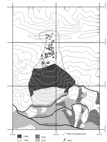
A concentration of ruins still exists in the upper part of the Morro da Queimada site. The cartography of those ruins has revealed vestiges of houses, walls and mining equipment (Figs. 2 and 3). The ruins are north of 15th August Street (Fig. 4), covering an area of about 250,000 m2. The area is limited to the north
by the top of the Ouro Preto range and to east and west by scarps that were created from the mining excavations. The only place where a similar set of ruins can be found is at the Passagem de Mariana village. Dwellers tell about the removal of blocks of canga, a ferruginous lithified surficial rock, from the ruins to be used in the building of new houses during the 1960s and 70s. This process can still be seen in the use of ruins as bases for new houses or parts of ruins in new buildings (Figs. 3a and b).
The study presented here was based on comparative analyses of aerial photographs and other available cartographic bases from different periods. The follow-ing cartographic bases have been used: 1950 aerial photographs (flight by Cruzeiro do Sul, scale 1:25,000), 1969 aerial photographs (flight by Cruzeiro do Sul, scale 1:10,000), 1986 aerial photographs (flight by Esteio, scale 1:30,000) and 1986 ortho-photos (flight by Esteio, scale 1:10,000).
The aerial photograph analysis involved the interpretation of a pair of photos with stereoscopy with ocular 3×. The methodology applied consists of a definition of the area used for each span of time measured and its proportion to the total area con-sidered. The measurement is done carefully, taking into account the relation between the distance of fixed and unchangeable points and the settlement front. Distances are measured with the help of a stereo micrometer and later compared to pairs of different dates. By linking the points that define the settlement front, a polygonal that represents the land-use area in given period is obtained. Although some distortion exists due to the conical projection of the aerial photo-graphs, measured and calculated values can be taken as acceptable due to the scope of the analysis and also due to the speed of the transformations.
Figure 2 Aspects of the ruins of the Morro da Queimada site. The ruins are mainly composed of “canga”, a lithified surficial rock formed of detrital fragments cemented by goethite. One may find ruins of houses, walls,mundeos, channels and other mining equipment
the plane-table mapping were plotted on the same basis of the aerial photographic survey.
All cartographic data were digitized to produce an integrated map with a uniform scale. By comparing
results obtained from different times it was possible to get a diagnosis of the evolutionary process of the area and an analysis of the annual land-use rates.
Figure 3 Photographs of recent use of the Morro da Queimada site. Recent land-use is achieved by the removal of ruin fragments for new buildings and also by new buildings in the middle of the site
with the 1998 topographic survey, provided an analy-sis of the area for 47 years. By determining land-use rates for periods of 19, 17 and 11 years, a median rate for the five decades was obtained. Fig. 5 and Table 1 represent the use evolution and calculated land-use rates.
Looking at the 1950s photos, one can see the absence of land use north of August 15th Street. Land was, however, partially used to the south of this street with low-density land use concentrated especially
north of Conselheiro Quintiliano Street. All the area which is now the Morro da Queimada, Morro Santana and Piedade and part of the Alto da Cruz neighbor-hoods was preserved from recent human interference. Ruins could be found in every natural relief, especially where the Morro Santana neighborhood is now.
Figure 4 The ruins of the Morro da Queimada site in detail. The area delimited by August 15th Street and the dotted line encloses the remaining set of ruins (north). The southern por-tion of the site has been completely used (see Fig. 5). Contours in meters
the area was completely used. Most of the houses were small with low-quality building materials. Land use at that time reached 4.3% of the total area (approximately 10,000 m2). For the analyzed period
(1950–1969), the land-use rate was thus 0.22%. Regarding the Morro Santana neighborhood, the vicinity of the main street (August 15th Street) was partially used and a great part of the ruins had been destroyed. The Piedade neighborhood did not exist at that time. The end of the 60s marks a more pro-nounced period of settlement, which also was not accompanied by urban planning.
1986 aerial photographs and orthophotos indicate consolidated urban use around August 15th street. Used area represented 26.3% of the total area (less than 70,000 m2). For the time span (1969–1986) the
annual land-use rate is 1.3% and 0.7% using as a base the time span 1950–1986. The set of ruins had not, however, been affected by any human interference, excepting the interference situated along the August 15th Street. The Morro Santana neighborhood settle-ment had, at this time, been completed with only a few vestiges of ruins. The Piedade neighborhood had also been established. Several problems related to slope stability along the Ouro Preto range were
Figure 5 The evolution of the Morro da Queimada land use since 1950. A conservative estimate of the annual land use rate (1.5%) of ruins of the Morro da Queimada site indicates that it will be completely destroyed before 2008
already known, and some of them had been analyzed in detail at this time (Carvalho, 1982; Sobreira, 1990; Sobreira et al., 1990).
The 1998 topographic survey and present field observations indicate that 68.2% of the total area is presently used (1,750,000 m2). This results in a
land-use rate of 3.8% a year (1986–1999) or 1.45% a year (1950–1999). A significant part of the set of ruins has been completely destroyed, with the population den-sity decreasing towards the north. The degree of human intervention is such that the possibility of urban rehabilitation seems unreasonable (Fig. 6). The Morro do Santana and Piedade neighborhoods are consolidated, and the lack of planning and effective public action have led to geological risks as the com-mon process within these areas (Sobreira, 1992b; Fonseca and Sobreira, 1997; Sobreira and Fonseca, 1998).
Figure 6 The visual effect of encroaching process. By comparing photographs from 1990 (photo A) and 1998 (photo B), it is possible to measure the speed of unplanned land-use. Take the highest point on both photographs for reference. At the top of both photos is the remnant set of ruins
Although this model may change, the fact is that land use has reached the main set of ruins at the Morro da Queimada neighborhood, and each intervention rep-resents damage to the cultural heritage of the city.
Conclusions and recommendations
Field and aerial photographic surveys indicate a clear process of “slummification” within neighborhoods of Ouro Preto City. Most of these areas are former min-ing areas and contain vestiges of ruins of the gold rush in Brazil in the 18th century. In the Morro Santana neighborhood, only a small set of ruins remains undamaged at the Morro da Queimada site. Projection of the annual land-use rates and the lack of public policies regulating the use of urban areas point to the complete destruction of the ruins at Morro da Queim-ada before 2008. Experience indicates that there is no reason to expect significant change of the official pub-lic posture that would include a more rational popub-licy
or urban planning. Therefore, it is absolutely neces-sary to take steps to stop the land use process of the Morro da Queimada. The only effective way to avoid the ensuing destruction of the site is to delimit a
non-edificandi area that would include the small remnant
of the set of ruins. This area may conveniently be defined according to the following UTM coordinates (central meridian 23°), indicated in Table 2.
econ-Table 2
Station Utm1 Utm2
1 665585 7747750
2 665570 7747835
3 665550 7747900
4 665525 7748120
5 665435 7748145
6 665312 7748110
7 665325 7748050
8 665387 7748040
9 665355 7747875
10 665325 7747825
11 655320 7747760
12 655255 7747725
13 655387 7747750
omic crisis now existing in Brazil, the only way to make this park become a reality is through the syn-ergy between public and private efforts in the building of a self-sustaining project.
Acknowledgements
This research was supported by FAPEMIG (FUNDAC¸ A˜ O DE AMPARO A` PESQUISA DO ESTADO DE MINAS GERAIS), grant 818/96. We thank M. Ayres, R. Myers and J.T. Silva for their editorial assistance.
References
Carvalho, E T (1982). Carta Geote´cnica de Ouro Preto, Dissertac¸a˜o de Mestrado, Universidade Nova de Lisboa, 95 pp.
Fonseca, M A and Sobreira, F G (1997) O escorregamento do bairro da Piedade, Ouro Preto, Minas Gerais: Processos de instabilidade em antigas a´reas de minerac¸a˜o. In2nd Pan-Amer-ican Symposium on Landslides, 1997, Rio de Janeiro. pp 139– 144. Associac¸a˜o Brasileira de Mecaˆnica dos Solos e Engen-haria Geote´cnica.
Fundac¸a˜o Joa˜o Pinheiro (1975).Plano de Conservac¸a˜o, Valoriza-c¸a˜o e Desenvolvimento de Ouro Preto e Mariana (Relato´rio Sı´ntese). Belo Horizonte
Sobreira, F G (1980). Levantamento de a´reas de risco geolo´gico no espac¸o urbano de Ouro Preto, Ouro Preto: Conveˆnio UFOP-Ministe´rio da Cultura/SPHAN, 85 pp.
Sobreira, F G, Arau´jo, L J and Bonucelli, T J (1990). Levantamento de soluc¸o˜es estruturais para a contenc¸a˜o de encostas em Ouro Preto, Ouro Preto: Conveˆnio UFOP-Ministe´rio da Cultura/SPHAN, 91 pp.
Sobreira, F G (1992a) Ouro Preto: un monumento en riesgo. In
2nd Simposio Latinoamericano sobre Risco Geologico Urbano, Pereira, Colombia. International Association of Engineering Geology pp 389–395 and 1419–1422.
Sobreira, F G (1992b) Urban landslides as a consequence of old mining in Ouro Preto, Brazil. InSixth International Symposium of Landslides, Christchurch. pp 1419–1422. International Association of Engineering Geology.
Sobreira, F G and Fonseca, M A (1998) Geologic risk resulting from the land use of old mining sites in the Piedade neighbor-hood, Ouro Preto, Minas Gerais, Brazil. InEighth International Congress of Engineering Geology, Vancouver, vol 7, pp 3119–3123.
Vasconcellos, D (1904)Histo´ria antiga de Minas Gerais. Imprensa official do Estado de Minas Gerais, Belo Horizonte.