Revista Brasileira de Recursos Hídricos
Brazilian Journal of Water Resources
Versão On-line ISSN 2318-0331RBRH, Porto Alegre, v. 23, e23, 2018 Scientific/Technical Article
https://doi.org/10.1590/2318-0331.231820160052
Influence of sewage disposal on the water quality of the Sucuru River alluvial aquifer
in the municipality of Sumé-PB, Brazil
Influência do lançamento de esgotos na qualidade das águas do aquífero aluvial do Rio Sucuru, no município de Sumé-PB
Jaqueline Pereira Salgado1, Mônica Amorim Coura1, Dayse Luna Barbosa1, Patricia Hermínio Cunha Feitosa1,
Marcela Antunes Meira1 and Janiro Costa Rêgo1
1Universidade Federal de Campina Grande, Campina Grande, PB, Brasil
E-mails: jaquelinesalty@gmail.com (JPS), mmonicadeac@gmail.com (MAC), dayseluna@yahoo.com.br (DLB), phcfeitosa@outlook.com (PHCF), marcelameiraa@gmail.com (MAM), janiro_rego@yahoo.com.br (JCR)
Received: November 29, 2016 - Revised: February 03, 2018 - Accepted: February 09, 2018
ABSTRACT
The objective of this study was to evaluate the influence of sewage discharge on the quality of the water exploited from the Sucuru River alluvial aquifer, located in the municipality of Sumé, Paraíba state, Brazil. The study was based on physical-chemical and microbiological analyses of the waters from nine wells located along the alluvium. The results of the indicators showed that the alluvial aquifer studied has the capacity to filter and disperse pollutants. It is possible to observe a gradual reduction of chlorides, chemical oxygen demand and total dissolved solids along the alluvial perimeter. Thus, urban sewage becomes a source of water recharge with potential to be reused. We concluded that the utilization of water from this type of aquifer, which has been intensified in recent dry years, can be established in a safe and sustainable way. However, a strict monitoring plan for controlling recharge groundwater levels is highly necessary. Further studies in this direction should lead to a model of adequate use of this system, which can be reproduced in the Brazilian semi-arid region.
Keywords: Alluvial aquifer; Aquifer pollution; Classification of groundwater.
RESUMO
O objetivo desta pesquisa foi avaliar a influência do lançamento de esgotos na qualidade da água explotada do aquífero aluvial do rio Sucuru, localizado no município de Sumé - PB. O estudo foi realizado a partir de análises físico-químicas e microbiológicas das águas de nove poços situados ao longo do aluvião. Os resultados dos indicadores mostraram que o aquífero aluvial estudado possui capacidade de filtrar e dispersar poluentes, sendo possível observar ao longo do perímetro aluvial uma redução gradativa de cloretos, demanda química de oxigênio e sólidos totais dissolvidos. Nesse sentido, o esgoto urbano se transforma numa fonte de recarga hídrica com potencialidade de ser reaproveitado. Conclui-se que o uso da água desse tipo de aquífero, intensificado nos recentes anos secos, pode se estabelecer de forma segura e sustentável mediante a recarga controlada do aquífero com acompanhamento rigoroso das condições qualitativas da água/esgoto circulante, associada a avaliações quantitativas. O aprofundamento de estudos nesta direção deve levar a um modelo de utilização adequada desse sistema, que pode ser reproduzido na região do semiárido brasileiro.
INTRODUCTION
Problems of water scarcity are constantly faced in various regions of Brazil and worldwide, especially in those affected by with water stress. Such situation has stimulated the use of sewage in the Artificial Recharge of Aquifers (ARA), as a form of water storage to restore or increase the level of utilization of subsurface water resources (MOURA, 2004; MISSIMER et al., 2012).
The semi-arid region of Northeast Brazil has scarce and poorly distributed surface and subsurface water resources. In addition, the indiscriminate growth in water demand and increase in pollution have intensely contributed to degrading the quality of the waters in the region and increasing environmental problems (SILVA; AZEVEDO; ALVES, 2014).
The region strongly depends on the exploitation of alluvial aquifers to meet the demand of scattered populations and the irrigation practice in family farming or small-scale agriculture. The main point in the exploitation of groundwaters lies in the renewal of this resource, which does not occur at the same rate of extraction. This may result in the exploitation of parts of the permanent reserves of the aquifer with risk of exhaustion, when the withdrawal is not properly monitored (ALBUQUERQUE et al., 2015).
In the long dry season, characteristic of semi-arid regions, alternative measures become necessary to guarantee that the high water demands are met. In these situations, the population generally intensifies the drilling of wells, especially to meet domestic and agricultural needs.
The number of well drillings has increased substantially in the region. In the Paraíba state, for instance, this number increased from 5,728 to 15,994 between 2004 and 2013, a growth of 179.2%, whereas the national growth was 56.5% (SIAGAS, 2013). Continuous use of these wells coupled to the disposal of untreated wastewaters in the open compromise groundwater quality. On the other hand, aquifer recharge using raw or treated domestic sewage may constitute an alternative to ensure the sustainability of irrigated activities and other water uses.
In sites where the hydrogeological conditions allow, the recharge carried out in superficial infiltration structures, such as infiltration basins or canals, could achieve considerable levels of treatment, due to the movement of the effluents through the soil, saturated layer and in the aquifer itself. This is the system called Soil Aquifer Treatment, or SAT, which has been successfully employed in different parts of the world. SAT systems provide high levels of treatment in terms of organic compounds (removal of BOD, COD, TOD, pathogenic organisms (fecal coliforms, cryptosporidium, giardia and virus) and inorganic compounds (nitrogen and heavy metals) (HAFER et al., 2001; ARNOLD and QUANRUD, 1998 apud HESPANHOL, 2002).
Sumé is one of the main municipalities included in this context. The surface reservoir (Public Dam of Sumé), which in the last decades of the past century had simultaneously supplied the urban population and an intense irrigated agriculture, currently is not able to meet any of these demands. The remaining irrigators in the area, which is crossed by dried and semi-destroyed water canals, resort to withdrawing groundwater from the small alluvial aquifer bordering their riparian lots. This resource, however, is
contaminated by sewage, which prevents the use for human supply and limits it for irrigation.
This study aims to evaluate the influence of disposing sewage from the Sumé city and its capacity of reuse in the Sucuru River alluvial aquifer, in order to identify the potential of using wastewaters in the recharge of aquifers.
The present study is part of multidisciplinary project: Strategies and Technologies for Water Scarcity Mitigation in Northeast of Brazil: Water Reuse, Managed Aquifer Recharge and Integrated Water Resources Management (BRAMAR, 2014). This project has a regional scope, associated with users and management bodies, to join efforts in cooperation with universities and companies in Germany. The project aims to contribute to improving strategies of planning and management of water resources in Northeast Brazil, by combating water scarcity and guaranteeing sustainable use of these resources in this region. More specifically, the investigation addresses aspects of recovery and reuse of waters utilized for managed aquifer recharge (BRAMAR, 2014).
Using sewage in the recharge of subsurface aquifers is a water management method still incipient in Brazil and, therefore, it becomes relevant to study the local characteristics and evaluate the potential of the aquifers in the revitalization of these waters along the alluvia in the Brazilian semi-arid region.
From observations in areas where the recharge is not controlled, we aimed to determine the physical, chemical and biological parameters and identify those with most significant reductions of concentration in the waters, to allow the introduction of specific techniques to treat the effluents generated, reducing costs and maintaining the flow levels in the wells along the alluvia.
GENERAL CHARACTERIZATION OF THE STUDY AREA
The municipality of Sumé, Paraíba state, according to IBGE (2010), has a population estimated at 16,691 inhabitants. In geographic terms, it is found in the Cariri region – Borborema Plateau, in the Drought Polygon (Polígono das Secas), with altitudes varying from 300 to 600 m, mean annual temperature between 21 °C and 32 °C and mean annual rainfall from 400 to 600 mm. Its climate is hot semi-arid (BShw) according to Köppen’s classification, with alternation of two well defined seasons: rainy season (scarce and irregular rains, high temperature and low humidity) and dry season, which may extend for up to eleven months (CPRM, 2000; FRANCISCO et al., 2012).
The municipal seat, city of Sumé, is situated on the banks of the Sucuru river, which is born in the Cariris Velhos mountain range, border between the states of Paraíba and Pernambuco, and flows eastward until it empties into the Paraíba river.
The Sucuru river basin, with area of 1652.5 km2, is therefore contained in the Paraíba river basin, one of the largest and most important ones in the state (Figure 1).
The Sumé city has a water supply system, but there are areas that do not yet have water distribution network and other areas that undergo permanent rationing.
Salgado et al.
which exploit the crystalline aquifer system, of fissured nature (local fractures) (CPRM, 2000; FRANCISCO et al., 2012).
The sewage system covers 66% of the city, but from this total only 33% is treated in a system of stabilization ponds, with two anaerobic ponds and one facultative pond (IBGE, 2010; PMS, 2015).
Economic activities in the region essentially consist of livestock farming, especially cattle, followed by goat and pig farming and plant extractivism. Production of tree cotton and temporary crops are representative in the economy of the region (CPRM, 2000), which makes the local economy strongly dependent on water availability for irrigation.
In the last decades, agricultural production has been compromised due to the low rainfalls. The largest impact was the deactivation of the irrigated perimeter, due to water scarcity in the Sumé dam, increasing the vulnerability of the families during dry periods, which represented heavy losses in the local production.
Hydrogeological characterization
In the Cariri paraibano region, as well as in approximately 89% of the state area, there is an almost exclusive predominance of Precambrian crystalline rocks, in which the occurrence of
groundwater is limited to localized, poorly branched, unconnected fractures. These fractures form isolated aquifers, with fissured porosity, which have low yield (average of 0.425 m3/h/m) and generally provide waters with high salt contents (SILVA NETO, 1993; CPRM, 2000).
Alluvial aquifers occur on the impermeable crystalline basement, on beds and banks of rivers and larger streams. They are shallow sedimentary deposits, of fluvial origin, with intergranular porosity, predominantly sandy lithology, interbedded with discontinuous clay or sandy clay lenses. Therefore, they are groundwater aquifers with small dimensions (narrow and shallow), but with easy access and high permeability (PARAÍBA, 2006).
The experimental investigation in this paper was conducted in the alluvial aquifer formed by the bed and banks of the Sucuru river, in an approximately 10-km-long segment that starts upstream the public dam of Sumé, crosses its urban periphery and covers almost all the extension of the former irrigated perimeter of Sumé.
effective porosity of 10% and average hydraulic conductivity of 8.36x10⁻⁴ m/s (VIEIRA; RÊGO; SRINIVASAN, 2002).
An alternative found to continue agriculture-livestock activities in the lots of the former perimeter was to irrigate with groundwater, withdrawn by wells in the Sucuru river alluvium. These wells have large diameter (1 to 5 m), in general fully penetrating, hand-dug and its walls are lined with Dutch bricks. In the region, they are referred to as ‘cacimbões’ or ‘Amazonas’ wells. Due to the empirical conditions with which they are constructed, there is no lithological profile for any of them.
Given its dimensional and hydraulic features, the alluvial aquifer tends to empty during the long period of the dry season, a process currently accelerated by the intense exploitation (RÊGO; ALBUQUERQUE; BOOCHS, 1989).
The natural recharge of groundwater in this aquifer occurs only in the short rainy season, mainly originated from the infiltration of part of the fluvial flow, when the rapid afflux of direct surface runoff raises the liquid surface level in the river, making it influential in the aquifer. This situation rapidly reverses after the rains stop, when the river then becomes effluent. This situation also remains for a short time, only the necessary for the groundwater level to decline to below the thalweg of the water course, emptying it completely. In summary, due to the pluviometric regime and the regional geological conditions, the rivers of the Cariri are intermittent, with short flow periods and long zero-flow periods (MOURA et al., 2010).
Thus, during most of the year, the only contribution to the recharge of the aquifer comes from the domestic sewage directly discharged into the Sucuru river or into the Pedra Comprida stream. Given this scenario, it becomes imperative to evaluate the local conditions and plan actions that can guarantee the continuous availability, both qualitatively and quantitatively, of the groundwater for the local irrigation. Evaluating water quality along the alluvium makes it possible to establish guidelines that stimulate the use of sewage in subsurface recharge, identifying the need for complementary treatments of these waters and management actions that allow for the multiple uses of the aquifer.
Identification of pollution sources and collection wells
An exploratory study on possible sources of pollution of the Sucuru river alluvial aquifer found sources caused by anthropogenic activities in the urban and rural areas, such as gas stations, car washes, urban and rural sewage, wastes from agriculture-livestock production, among others, which influence water quality, despite not being located directly above the aquifer.
In addition, treated sewage, effluents from stabilization ponds, is discharged directly into the Sucuru river and, after finding the dry bed, it infiltrates rapidly, reaches the water table and is incorporated into the natural subsurface flow.
The wells in which water samples were collected for analysis are situated within the borders of the alluvial aquifer, i.e., on the banks of the river (Figure 2). The Table 1 presents the physical dimensions and location of the collection wells.
The criteria adopted to choose the nine wells, among the 32 existing in the area, encompass factors such as: physical condition of the wells, distance between them, ease of access for collection, use of the well by the population, anthropogenic activities in the surroundings (use of pesticides, fertilizers, and various polluting sources), underground dams, among others. These criteria were used to better characterize, at first, the possible influences on the water quality of the Sucuru river alluvial aquifer.
The wells are all ‘Amazonas’ wells, of private service, and are used by the population, except P01 which has been abandoned, and P02, which was has been restored and is not being used yet.
The wells P01 and P02 are located in the part of the alluvium that crosses the urban perimeter of Sumé. The well P03, approximately 1 km away from the urban center, and P04, are used for grass irrigation and animal watering. The wells P05, P06 and P07 provide water for corn irrigation and animal watering. The well P08 is exclusively used to irrigate tomato crops, and the well P09 for grass irrigation and watering of a herd of goats.
Between the wells P04 and P05, P06 and P07, and P08 and P09, there are underground dams, all submerged-type, 33 m long, occupying the entire alluvial thickness, reaching the crystalline basement, and constructed with stones covered by plastic sheeting.
SAMPLING PROCEDURE AND ANALYSES
Water samples for the analyses were collected from May to November 2015. On average, two analyses were carried out every month. It is important to emphasize that the study was planned to obtain data to characterize rainy and dry periods. However, there were no significant rains in the region along the period of analyses, which does not compromise the results obtained.
Laboratory analyses were carried out at the Sanitation Laboratory of the Federal University of Campina Grande (UFCG), Campus of Campina Grande, 134 km away from the municipality of Sumé. The procedures of collection equipment sterilization, and packing and storage of samples followed the recommendations described in the Standard Methods for the Examination of Water (APHA, 2012) in accordance with those of the Guia Nacional de Coleta e Preservação de Amostras: água, sedimento, comunidades aquáticas e
Table 1. Physical dimensions and location of the collection wells for water analysis.
Well Static water level (m) Well bottom depth (m) External Ø (m) Geographic coordinates Lat Long
Salgado et al.
sedimentoslíquidos (CETESB, 2011). Collection equipment, besides being carefully washed, rinsed with distilled water and sterilized with alcohol after each collection, for each well, were acclimated with the water to be collected. The samples were kept in the ice, due to the long distance from the collection site to the laboratory. For samples of microbiological analyses, the collections included additional procedures, and the samples were placed in containers, previously sterilized in autoclave at 1 atm, 121 °C, for 15 min, and separately maintained in thermal boxes with ice.
The physicochemical indicators selected for this study (Chart 1) followed the criteria of the standard techniques of APHA (2012).
Temperature and pH were determined in the field. Dissolved oxygen was determined by the Winkler method, with azide modification and oxygen fixation in the field, with addition of 1 mL of manganous sulfate and 1 mL of alkali-iodide-azide with immediate homogenization in glass BOD bottle. Samples for the other physicochemical analyses were collected and placed in 1000 mL polypropylene containers.
The indicators Thermotolerant Coliforms and E. Coli represented the microbiological analyses and were quantified by the membrane filtration and enzymatic substrate techniques, respectively, also according to APHA (2012).
Figure 2. Map of location of the water collection wells in the Sucuru river aquifer.
Chart 1. Physicochemical indicators used and analysis methodologies. Parameters Analysis methodologies Bicarbonate Alkalinity
Acid-base neutralization titration Carbonate Alkalinity
Total Alkalinity Calcium
EDTA titration method Magnesium
Chlorides Argentometric Method (Mohr’s Method)
Electrical Conductivity Instrumental Method – Conductivity Meter
BOD BOD Bottle Method
COD Closed Reflux Method
Iron Phenanthroline Colorimetric Method Nitrate Cadmium Reduction Column Method Nitrite Diazotization Method Ammoniacal Nitrogen Titration Method
DO Winkler-Azide Method pH Determination in pH meter Potassium
Flame Photometry Sodium
Salinity Instrumental Method – Conductivity Meter
Total Dissolved Solids TDS Determination at 180 °C Temperature Determination by Thermometer
Characterization of aquifer vulnerability to contamination
Most methodologies to evaluate vulnerability require a large amount of data (on geology, water table depth, hydraulic conductivity, porosity, recharge, soil use and others), which often are not available. The GOD (Groundwater occurrence, Overall lithology of the unsaturated zone, Depth to the water table) methodology precisely meets this requirement of using more accessible information, such as water table depth, lithologies of vadose zone and confining layers, and aquifer conditions (FOSTER et al., 2006).
In addition to its easy application, the methodology has simple interpretation. Such characterization is based on the following parameters: G – groundwater hydraulic confinement in
the aquifer; O – overlaying strata (vadose zone or confining layer), in terms of the hydrogeological characteristic and consolidation degree determining their capacity to attenuate the contaminant; and D – depth to the water table or to the confined aquifer roof (FOSTER et al., 2006).
Each parameter is estimated by indices, for which different scales are defined. Aquifer vulnerability, taken as the product of the respective indices of these parameters, is classified according to five intervals, namely: 0.0-1.0 (Insignificant); 0.1-0.3 (Low); 0.3-0.5 (Medium); 0.5-0.7 (High) and 0.7-1.0 (Extreme) (FEITOSA et al., 2008).
To obtain a final vulnerability map, three maps of the alluvium were elaborated, corresponding to the parameters of the method. These thematic maps were overlapped to obtain the vulnerability map of the alluvial aquifer for the studied area.
The maps were elaborated using the Spatial Analyst Tool of ArcGIS 10.3®. This program was used to interpolate the parameters according to the values assigned to the characteristics, as described in the GOD methodology. The interpolation method used was the IDW (Inverse Distance Weighting), which corresponds to the interpolation between each point as a local influence, decreasing as the distance between point increases.
Classification according to the CONAMA Resolution nº 396/2008
The classification according to the CONAMA Resolution no 396/08 (CONAMA, 2008) is defined as the qualification of groundwaters based on quality standards which allow for establishment of their framework. Groundwaters are classified into six classes according to the quality level required by the predominant uses.
The parameters chosen for classification were chloride, sodium and the basic ones required by the CONAMA Resolution no 396/08 (CONAMA, 2008), total dissolved solids, nitrate, thermotolerant coliforms and E. Coli.
RESULTS AND DISCUSSION
The local factors which must be characterized to support the aquifer recharge project include: aquifer water quality characteristics, existing or potential pollution from landfills or any other activities, and soil contaminants that may be leached during the recharge,
which were the focus of the present study. Based on the data surveyed, it is possible to evaluate the feasibility of using domestic sewage in the artificial recharge of aquifers to promote its reuse.
Sources of pollution
In the urban area of the aquifer, 16 points of pollution were found (Table 2, Figure 3), situated between the wells P01 and P04 (Figure 3). The points 3, 6, 7, 8, 9, 10, 12, 13, 14 and 15 dump wastes directly into the Sucuru river, whereas the others dump them into the Pedra Comprida stream, which is its main tributary. In the studied aquifer, pollution sources predominantly result from sanitary sewage, whose main components are organic matter, thermotolerant coliforms and some inorganic chemical species which contribute to increasing water salinity, particularly chloride.
The rural area starts from the well P04, and the pollution sources are related to agriculture-livestock activities and effluents from rudimentary cesspits from the local communities. Thus, each well has a type of pollution characteristic of its surrounding area. The pollution sources of the rural area contribute differently, mainly exhibiting a scattered pattern.
Water quality analysis
The data obtained in the present study were subjected to normality tests according to the Shapiro-Wilk criteria and showed normal distribution. Descriptive statistical analysis provided means, minimums, maximums and coefficients of variation for all indicators listed in Chart 1.
The coefficients of variation were mostly high, above 30% (PIMENTEL-GOMES, 1985). Environmental factors such as variable conditions of sewage disposal, presence or absence of animals, utilization of well waters at variable rates, among others, have contributed to such variation.
Table 2. Pollution sources in the urban area. Pollution
source Quant. source pointsPollution Predominant pollutants Cemetery 1 16 Necro-leachate
Industry 1 15 Organic Matter
and (various chemicals) Discharge
of sewage, predominantly sanitary and untreated
4 8, 9, 10 and 11 Organic Matter
Car washes 4 5, 6, 12 and 13 Surfactants, grease, gasoline
Dump 1 7 Leachate
Salgado et al.
The maximum values allowed (MVA) for the various uses of water were continually violated in the wells along the alluvium during the collection period, according to the criteria of the Ministry of Health Ordinance no 2914/2011 (BRASIL, 2011) and CONAMA Resolution no 396/2008 (CONAMA, 2008), especially for chlorides, thermotolerant coliforms, hardness, sodium, total dissolved solids and turbidity.
The alluvial aquifers of the Brazilian semi-arid region exhibit natural quality, especially with respect to salinity. Unlike those from the fissured aquifer (crystalline system), these alluvial groundwaters remain in contact with the rocks on which the flow for a shorter time, because of the easy exhaustion and renewal due to the small dimensions of the alluvial pack and the alternation of the river-aquifer relationships already described. These natural qualitative conditions are also determined by the alluvial rock nature, predominantly sandy, sedimentary and subjected to natural leaching, from the processes of erosion and fluvial transport.
Organic matter
Surface runoff and percolation of the biodegradable matter in the soil led to good conditions of sewage purification because, in the aquifer perimeter, the BOD varied from 0.9 to 4.4mg/L,
and the maximum value occurred in the urban area. The same variation range was found by other researchers in similar aquifers, such as Bahia et al. (2011).
COD in the alluvial perimeter varied between 8.0 mg/L and 340 mg/L. Such high concentration may be associated with the use of agrochemicals, evidencing the need to evaluate the concentrations of these pesticides simultaneously to those of total and dissolved COD in dry and rainy periods.
DO values were all low, and the mean values varied from 1.2 to 3.5 mg/L, which is common in groundwaters because most of the air is consumed in organic matter oxidation during water percolation in the aerated zone.
Thermotolerant Coliforms
All wells evaluated had TTC (Thermotolerant coliforms), and E. Coli was confirmed in most analyses, which demonstrates fecal contamination of the water in the entire perimeter of the alluvium (Figure 4). Such contamination results from the domestic sewage and warm-blooded animal feces dumped into the aquifer and around the wells, respectively.
Presence of these microorganisms in the wells P01, P02 and P03 may be associated with the proximity to the urban area and the
raising of cattle and horses in the rural area. From the well P06, there is again an increase in the concentration of microorganisms, with higher incidence of these bacteria in the well P09, which is due to the influence of the sewage from a small village located upstream, besides large presence of sheep around the well, intensified from July 2015 on.
For thermotolerant coliforms and E. Coli, all wells were above the MVA for human consumption in most collections, according to the CONAMA Resolution nº 396/2008 (CONAMA, 2008). Nevertheless, for irrigation and animal watering, the MVA were below the limits established for these uses (200/100 mL and 1000/100 mL), respectively. P04 and P05 showed lower TTC concentrations, with maximum value of 6 CFU/100 mL in only one collection, indicating that a casual contamination may have occurred.
Chemical species
The chloride ion is present in groundwaters at concentrations lower than 100 mg/L (LIMA; FRANÇA; LOIOLA, 2014). High chloride concentrations in these waters may reflect pollution by wastewaters, especially domestic.
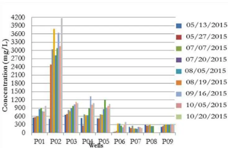
In the samples analyzed along the alluvium, chloride concentration varied from 35 to 1200 mg/L, except in the well P02, which showed much higher values (Figure 5). Comparing these results to those in the legislation (CONAMA Resolution nº 396/2008 and Ministry of Health Ordinance nº 2914/2011), we noted that 78% of the analyzed wells showed values above 250 mg/L, the maximum allowed for human consumption. For irrigation, according to the criteria of the CONAMA Resolution nº 396/2008, this value ranges from 100 to 700 mg/L. In the wells P01, P02, P03, P04 and P05, the values obtained exceed the MVA for this purpose. According to Stein et al. (2014), high chloride concentrations are common in groundwaters of semi-arid environments.
It is worth highlighting that chloride concentrations in the well P02 were higher than in the others because this well is more influenced by sanitary sewage, due to its location. The wells P01, P03, P04 and P05 are influenced also by the pollution from the
urban area, but there is a reduction in chloride concentration. In wells located farther away from the urban center (P06, P07, P08 and P09), there is a drastic reduction in chloride concentrations.
Such reduction cannot be attributed to filtration or removal processes, but instead to the high dispersion of this salt in the alluvium, because chloride is conservative and completely soluble in water. Thus, specific studies on dispersion coefficients in alluvial aquifers are fundamental and may represent great advances in the development of techniques to recover water quality and storage in aquifers of the semi-arid region.
Sodium is always present in groundwaters due to its high degree of solubility (HEM, 1985). Its spatial-temporal variation in the studied waters remained within the range from 55 mg/L to 1470 mg/L. According to the CONAMA Resolution nº 396/2008, the MVA in the water for human consumption is 200 mg/L. In the analyzed wells, the mean concentrations were all above this value. Although sodium is a relevant parameter for irrigation, since it can cause soil salinization, there is no limit of MVA for irrigation water.
According to the Tukey test applied to sodium data, four concentrations were statistically different in the alluvium. Group 1 comprises waters from the wells P06, P07, P08 and P09 (means between 209 and 232.22 mg/L). Group 2 is formed by waters from the wells P01, P04 and P05, with variation from 363.00 and 422.89 mg/L. In group 3, waters from the wells P01, P03 and P05 were similar, with variation from 422.89 and 465.67mg/L. The well P02 showed sodium concentrations statistically different from those of the other 3 groups, with much higher mean value, 1446.67 mg/L, evidencing the strong influence of the sodium from the sanitary sewage discharged into the aquifer. Still regarding sodium concentrations, it is interesting to note a reduction along the aquifer, since the wells P06, P07, P08 and P09 (Group 1) showed the lowest concentrations.
Nitrate and nitrite concentrations were not found within the practical quantitation limits (PQL) according to the Ministry of Health Ordinance nº 2914/2011 and CONAMA Resolution no 396/2008, in the Sucuru river alluvial aquifer. The reasons may lie in the fact that the collections occurred during the dry period, which hinders nitrogen percolation, and in the low concentrations of ammoniacal nitrogen in the sewage discharged into the aquifer, on average below 1.0 mg NH4+-N/L. It is important to emphasize Figure 4. Spatial-temporal variation of thermotolerant coliforms
in the alluvial aquifer wells.
Salgado et al.
that this study will contemplate, in a second step, collection of samples during the rainy period, which may either confirm or disprove the presence of nitrate and nitrite in this aquifer.
Risk of salinity and ionic classification of the alluvial water
Total dissolved solids (TDS) are considered as a good parameter to indicate water salinity level, because they are related to water electrical conductivity. According to APHA (2012), electrical conductivity can be used to estimate TDS concentration in a water sample. Mean TDS values varied from 843 to 5930 mg/L. Only the well P07 showed concentration below the MVA of 1000 mg/L (values for human consumption according to the CONAMA Resolution no 396/2008 and Ministry of Health Ordinance no 2914/2011). The waters from all the other wells were considered as inadequate for human consumption.
EC values ranged from 0.8 to 9.6 mS/cm, and the highest ones were found in the urban area, represented by the well P02, with a gradual reduction along the alluvium. High EC values in P02 may be associated to the natural dissolution of ions from the local soil or to sewage percolation. In waters from the wells P01, P02, P03, P04 and P05, EC values varied between 2.0 and 9.6 mS/cm.
In general, these waters are not recommended for irrigation, due to high salinity. Nevertheless, they can be used to irrigate plants with very high tolerance to salinity (cotton, annual ryegrass, sugar beet, Bermuda grass, safflower, barley, wheat, etc.) in well-managed soil (LIMA; FRANÇA; LOIOLA, 2014). In the other wells, salinity is considered as intermediate and the waters can be used for irrigation, but with a few precautions.
For salinity and electrical conductivity (Table 3), there are three groups of means (G1, G2 and G3) statistically different according to the Tukey test.
The waters of the alluvium were statistically equal in the wells P06, P07, P08 and P09, with mean values ranging from 534.11 to 724.11 mg/L for salinity and from 1.01 to 1.32 mS/cm for electrical conductivity. The same occurred with Group 2, whose means were statistically equal in the wells P01, P03, P04 and P05. Group 3 showed a high value, statistically differing from the others, for both salinity (4281.11 mg/L) and electrical conductivity (7.92 mS/cm), due to its location in the urban area (point of domestic sewage disposal). Thus, water quality increases along the alluvium regarding the parameters sodium, salinity and electrical conductivity.
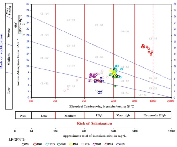
Irrigation water categories were evaluated according to the criteria of the United States Salinity Laboratory, based on the data of sodium, calcium, magnesium, total dissolved solids and electrical conductivity. This evaluation clearly demonstrates the predominance of high to very high risk for the alluvium, and only in the point P02 the risk is considered as extremely high (Figure 6). Consequently, the utilization of these waters is conditioned on the cultivation of salt-tolerant species with a good absorption of these salts, in order to reduce the risks of soil salinization and sodification Oliveira et al. (2013) also found high salt levels in the waters from the wells of the settlement of the Apodi Plateau-RN, characterized as a semi-arid region.
The Piper diagram (Figure 7) presents the ionic classification of the water, showing that the alluvium has predominance of chloride sodic water (91%), and small proportions of chloride magnesian (4%), bicarbonate sodic (4%) and mixed chloride (1%) waters. Considering cations and anions separately, 95% of the samples were sodic with regards to cations and 96% were chloride regarding anions. Nevertheless, it is not possible to claim that this classification is exclusively related to the natural components of the aquifer, due to the strong influence from sewage disposal.
Vulnerability to contamination
In the present study, the vulnerability evaluated in the alluvial aquifer was hydrogeological, defined according to the set of essential features of the aquifer strata determining its sensitivity to the adverse effects of a contaminant load applied on the surface (FOSTER et al., 2002). Thus, vulnerability depends on the easy access of the contaminant to the saturated zone and on the capacity of the layers above it to filter contaminants, attenuating their effects (MEDEIROS et al., 2011).
Figure 8 presents the spatial distribution for the three parameters of the GOD method.
As an estimate of the parameter groundwater hydraulic confinement, we used in the entire area the value 1.0, indicated for this case because the aquifer is free, very shallow and covered only by unconsolidated sediments.
The classification of overlaying strata (O) was elaborated based on the lithological profiles of drillings performed in the alluvial pack, described by Vieira (2002). Values were assigned to different types of substrate, as 0.4 for clay, 0.5 for silt, 0.7 for fine to medium sand and 0.8 for coarse sand to gravel. When the strata found in the drillings were clayey sand, loamy sand, etc., we calculated the mean of the values assigned to the sediments of the mixture.
To create the map of distance to water table (D), the value 0.9 (distances shorter than 5.0 m) was assigned to the entire aquifer extension. Although water table depths may reach high values, especially in the dry season, the aquifer in the rainy season tends to be completely saturated. Therefore, in this period and in the first
Table 3. Tukey test for Salinity and Electrical Conductivity data.
Wells Salinity Mean
(mg/L) G 1 G 2 G 3 Mean EC (mS/cm) G 1 G 2 G 3
1 1345.89 ** 2.43 **
2 4281.11 *** 7.92 ***
3 1334.89 ** 2.54 **
4 1234.89 ** 2.27 **
5 1209.11 ** 2.26 **
6 572.44 * 1.08 *
7 534.11 * 1.01 *
8 696.50 * 1.26 *
9 724.11 * 1.32 *
Figure 6. Risks of salinization and sodification in the Sucuru river alluvium according to the United States Salinity Laboratory.
Salgado et al.
Figure 8. Thematic maps of each level of information of the GOD method.
months of the dry season, when the aquifer naturally begins to empty, such unfavorable situation in terms of vulnerability occurs.
The final indices calculated varied from 0.3 to 0.7, with predominance of values in the range from 0.5 to 0.7, characterizing the aquifer as of medium to high vulnerability (Figure 9). This result, however, predominantly reflects the influence of the parameter O of the method, since the parameter D obtained had a single value for the entire aquifer (0.9) – D<5.0m. This is due to the reduced depths of the water tables measured, all below 5.0m.
To better consider the effects of water table depth variations, the limits originally indicated by the method were modified. Thus, the limits of the class indicated for the parameter D were divided by 10, to represent the specific conditions of the shallow aquifer. For instance, the value 0.9 began to correspond to the distance D<0.5m; for 0.5m<D<2.0m, the value began to correspond to 0.8 and so on. In this way, variations in water table depth were better represented (Figure 10).
The vulnerability resulting from this modification (Figure 11) provides more information and, therefore, is preferred over the one obtained with the limits of the original method (Figure 9).
Given the small dimensions of the aquifer and the low variation of its vulnerability (Figure 11), the results found represent important information for the management of water resources regarding the artificial recharge produced in the aquifer by sewage
Figure 9. Map of vulnerability of the Sucuru river alluvial aquifer, with the original GOD method.
Figure 10. Thematic map of the distance to water table (D) with the modified GOD method.
disposal. To attenuate the polluting effects of this practice, treated or untreated urban sewage should be discharged in areas of lower vulnerability, which currently does not occur because of the location of the sewage treatment station (stabilization pond) of Sumé, situated in the area of highest vulnerability of the alluvial aquifer.
CONCLUSION
The lack of planning and management in the recharge of underground resources in the studied area is evidenced by the compromised quality of the waters, which is affected by the number of wells drilled without the technical criteria needed and in inadequate sites, absence of sanitary protection slab, inadequate height of well hole, and also by the large amount of potentially polluting local activities.
Comparing the results of the quality indicators evaluated with the reference values of the CONAMA Resolution no 396/2008 and Ministry of Health Ordinance no 2914/2011, the maximum values allowed were violated, indicating that the waters from the Sucuru river alluvial aquifer in Sumé could only be employed, without treatment, for the least restrictive preponderant use or in activities that do not require quality standards.
High levels of salts restrict the use of the waters even for irrigation, which becomes conditioned on the cultivation of salt-tolerant species and with special care in soil management.
The contribution of this study in accordance with the objectives proposed lies in the confirmation of the alluvial aquifer capacity to filter pollutants. In this context, it was possible to observe along the alluvial aquifer a gradual reduction in the values of chlorides, total dissolved solids and chemical oxygen demand.
Based on its characteristics, the aquifer has medium to high vulnerability. However, even under the above-mentioned qualitatively unfavorable conditions, the groundwater of the studied alluvial aquifer needs to be employed in agriculture-livestock activities to attenuate the water scarcity of the region. From this point of view, urban sewage becomes a source of water recharge and can be reused.
This use of the aquifer, which has been intensified in the recent dry years, can only be established in a safe and sustainable way by rigorous monitoring of qualitative conditions of the water/ sewage, associated with quantitative evaluations, to define together an adequate model of management of this system which tends to be reproduced in the small cities of the semi-arid region.
The use of effluents in the artificial recharge of aquifers is an important instrument to guarantee the balance between offer and demand of water in various regions of Brazil. Nonetheless, it is important to broaden the discussion on the various aspects that may influence this practice or even be impacted by it.
Brazilian environmental diversity intensifies the need for studies in different physical and social scenarios, specifically in semi-arid regions. These studies will support the creation of laws adapted to the different regional characteristics, so that the practice is performed according to adequate technical principles, economically viable, socially accepted, and safe, in terms of environmental preservation and protection of the multiple uses involved.
This study consists in a step towards the adoption of strategies of reuse of alluvial aquifers recharged with wastewaters. Evaluating the action of the aquifer in the revitalization of groundwaters
influenced by waters polluted by anthropogenic activities from small cities and rural communities situated in Northeast Brazil allows for the adaptation of innovative technological solutions, supporting future research, such as modeling of flow and transport of pollutants in alluvial aquifers in the semi-arid region.
REFERENCES
ALBUQUERQUE, C. G.; MONTENEGRO, S. M. G. L.; MONTENEGRO, A. A. A.; FONTES JÚNIOR, R. V. P. Recarga de aquífero aluvial sob uso agrícola. Revista Águas Subterrâneas, v. 29, n. 1, p. 60-71, 2015.
APHA – American Public Health Association, AWWA – American Water Works Association,WEF – Water Environment Federation. Standard methods for the examination of water and wastewater. 22th ed. Washington: APHA, 2012.
BAHIA, V. E.; FENZI, N.; LEAL, L. R. B.; MORALES, G. P.; LUÍZ, J. G. Caracterização hidrogeoquímica das águas subterrâneas na área de abrangência do reservatório de abastecimento público do Utinga - Belém (PA). Águas Subterrâneas, v. 25, n. 1, p. 43-56, 2011.
BRAMAR. Strategies and technologies for water scarcity mitigation in northeast of brazil: water reuse, managed aquifer recharge and integrated water resources management. Descrição projeto de pesquisa de cooperação bilateral Brasil-Alemanha. Campina Grande: UFCG; Aachen: RWTH Aachen University, 2014. (Relatório Parcial).
BRASIL. Ministério do Meio Ambiente. CONAMA – CONSELHO NACIONAL DO MEIO AMBIENTE. Resolução nº 396, de 03 de abril de 2008. Dispõe sobre a classificação e diretrizes ambientais para o enquadramento das águas subterrâneas e dá outras providências. Diário Oficial [da] República Federativa do Brasil, Brasília, DF, 07 abr. 2008. BRASIL. Ministério da Saúde. Portaria MS nº 2914, de 12 de dezembro de 2011. Dispõe sobre os procedimentos de controle e de vigilância da qualidade da água para consumo humano e seu padrão de potabilidade. Diário Oficial [da] República Federativa do Brasil, Brasília, DF, 14 dez. 2011.
CETESB – COMPANHIA AMBIENTAL DO ESTADO DE SÃO PAULO. Guia nacional de coleta e preservação de amostras: água, sedimento, comunidades aquáticas e efluentes líquidos. São Paulo: CETESB; Brasília: ANA, 2011.
CPRM – Companhia de Pesquisa de Recursos Minerais/Serviço Geológico do Brasil. SUMÉ – FOLHA SB.24-Z-D-V. Brasília, DF: CPRM, 2000.
FOSTER, S.; HIRATA, R.; D’ELIA, M.; PARIS, M. Proteção da qualidade da água subterrânea: um guia para empresas de abastecimento de água, órgãos municipais e agências ambientais. Brasília: Groundwater Managemente Advisory Team, 2006.
Salgado et al.
FRANCISCO, P. R. M.; CHAVES, I. B.; CHAVES, L. H. G.; LIMA, E. R. V. Detecção de mudança da vegetação de caatinga. Revista Brasileira de Geografia Física., v. 5, n. 6, p. 1473-1487, 2012. http:// dx.doi.org/10.26848/rbgf.v5i6.232834.
HEM, J. D. Study and interpretation of the characteristics of natural waters. 3. ed. Washington: Geological Survey Water-Supply Paper, 1985. 265 p.
HESPANHOL, I. Potencial de reuso de água no Brasil agricultura, industria, municípios, recarga de aqüíferos. RBRH: Revista Brasileira de Recursos Hídricos, v. 7, n. 4, p. 75-95, out./dez. 2002.
IBGE – Instituto Brasileiro de Geografia e Estatística. Censo 2010. 2010. Available from: <http: //www. http://censo2010.ibge.gov. br>. Access on: 12 dec. 2015.
LIMA, J. O. G.; FRANÇA, A. M. M.; LOIOLA, H. G. Implicações hidroquímicas da condutividade elétrica e do íon cloreto na qualidade das águas subterrâneas do Semiárido Cearense. Revista Virtual de Química, v. 6, n. 2, p. 279-292, 2014.
Medeiros, C. M.; Barbosa, D. L.; Ribeiro, M. A. F. M.; Santos, A. F. D.; Albuquerque, J. P. T. A.; Rêgo, J. C. Comparação dos métodos de vulnerabilidade na região do baixo curso do rio Paraíba, Brasil. In: WORLD WATER CONGRESS, 14., 2011, Porto de Galinhas. Anais… Ipojuca: IWRA, 2011.
MISSIMER, T. M.; DREWES, J. E.; AMY, G.; MALIVA, R. G.; KELLER, S. Restoration of Wadi aquifers by artificial recharge with treated waste water. Ground Water, v. 50, n. 4, p. 514-527, 2012. http:// dx.doi.org/10.1111/j.1745-6584.2012.00941.x. PMid:22536878.
MOURA, A. N. Recarga artificial de aquíferos: os desafios e riscos para garantir o suprimento futuro de água subterrânea. In: CONGRESSO BRASILEIRO DE ÁGUAS SUBTERRÂNEAS, 13., 2004, Cuiabá. Anais… Cuiabá: ABAS, 2004.
MOURA, G. S. S.; BARBOSA, M. P.; MOURA, C. S.; SOUZA, M. M. P. S.; MOURA, A. E. S. S. Uso do sensoriamento remoto na análise espaço temporal dos açudes Prata II e São Paulo, frente aos efeitos climáticos, município de Prata-PB. In: SIMPÓSIO BRASILEIRO DE CIÊNCIAS GEODÉSICAS E TECNOLOGIAS DA GEOINFORMAÇÃO, 3., 2010, Recife. Anais… Recife: UFPE, 2010. OLIVEIRA, H. A.; BEZERRA, H. N.; ARAÚJO, J. M. S.; TAVARES, L. A. F. Qualidade de águas de poços dos assentamentos da Chapada do Apodi-RN para o uso na agricultura. HOLOS, v. 1, 2013. PARAÍBA. Secretaria de Estado da Ciência e Tecnologia e do Meio Ambiente. Agência Executiva de Gestão de Águas do Estado da Paraíba. Plano estadual de recursos hídricos: resumo executivo. Brasília, DF: AESA, 2006. (Volume 1). 112 p.
PIMENTEL-GOMES, F. Curso de estatística experimental. 12. ed. Piracicaba: Livraria Nobel, 1985.
PMS – PREFEITURA MUNICIPAL DE SUMÉ. Informações do município. 2015. Available from: <www.sume.pb.gov.br/>. Access on: 15 apr. 2016.
RÊGO, J. C.; ALBUQUERQUE, J. P. T.; BOOCHS, P. T. Modelo de fluxo e de manejo de um aquífero aluvial da região semi-arida paraibano. In: CONGRESSO BRASILEIRO DE ÁGUAS SUBTERRÂNEAS, 6., 1989, Porto Alegre. Anais…, Porto Alegre: ABAS, 1989.
SIAGAS – Sistema de Informações de Águas Subterrâneas. Banco de dados 2013. 2013. Disponível em: <http://siagasweb.cprm.gov. br/layout/pesquisa_coordenada. php>. Access on 15 apr. 2015.
SILVA NETO, A. F. Avaliação dos recursos hídricos e uso da terra na bacia do alto Rio Sucuru, com base em Imagens TM/LANDSAT-5. 155 f. Dissertação (Mestrado em Engenharia Agrícola) - Universidade Federal da Paraíba, Campina Grande, 1993.
SILVA, M. B. R.; AZEVEDO, P. V.; ALVES, T. L. B. Análise da degradação ambiental do alto curso da Bacia Hidrográfica do rio Paraíba. Boletim Goiano de Geografia (Online), v. 34, n. 1, p. 35-53, jan./apr. 2014.
STEIN, P.; SILVA, F. E.; SILVA, A. I. M.; LIMA, G. L. G.. A qualidade das águas subterrâneas do município de Baraúnas/RN. Carpe Diem: Revista Cultural e Cientifica do UNIFACEX, v. 12, n. 1, p. 1-14. 2014.
VIEIRA, L. J. S. Emprego de um modelo matemático de simulação do fluxo subterrâneo para definição de alternativas de explotação de um aquífero aluvial. 2002. Dissertação (Mestrado em Engenharia Civil) - Universidade Federal da Paraíba, Campina Grande, 2002.
VIEIRA, L. J. S.; RÊGO, J. C.; SRINIVASAN, V. S. Aplicação de um modelo matemático de simulação do fluxo subterrâneo para definição de alternativas de explotação de um aquífero aluvial. In: SIMPÓSIO DE RECURSOS HÍDRICOS DO NORDESTE, 6., 2002, Maceió. Anais… Campina Grande: ABRH, 2002. p. 55.
Authors contributions
Jaqueline Pereira Salgado: Development of the research, experimental work, analysis of results.
Mônica de Amorim Coura: Development of the research, orientation of the experimental work, orientation of the experimental results analysis, paper revision.
Dayse Luna Barbosa: Development of the research, orientation of the experimental results analysis, paper revision.
Patrícia Hermínio Cunha Feitosa: Orientation on the discussions, paper revision.
Marcela Antunes Meira: Mapping, application of the GOD method.