3D LAND COVER CLASSIFICATION BASED ON MULTISPECTRAL LIDAR POINT CLOUDS
Texto
Imagem

Documentos relacionados
In the Machadinho d’Oeste study area, the 2001 Landsat ETM image was used to conduct land use/ cover classification, consisting of 12
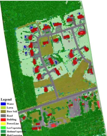
Aiming to evaluate the performance of four ground filtering algorithms in different classes of land use and land cover, a visual classification was performed (Figure 1).
Neste contexto, os objetivos desta dissertação são os de compreender melhor o desenvolvimento biopsicossocial em crianças e jovens com Síndrome de Goldenhar, e de que
Se os computadores e a internet são, hoje em dia, considerados ferramentas fundamentais para o estudo, o desempenho de uma profissão e mesmo para o exercício
L’idée de consacrer une séance à la mise en scène et à la mise en exposition de la chasse dans les cultures extra-européennes est née d’un double constat : d’une part, les
Several authors have already focused on the problem of automatic land cover mapping from multitemporal and multispectral satellite images of medium spatial resolution
We compare a fuzzy-inference method with two other computational intelligence methods, decision trees and neural networks, using a case study of land cover classification from
