Bolm Inst. oceanogr., S Paulo, 32(1) :77-81, 1983
INFLUENCE OF MARINE AND CONTINENTAL PROCESSES ON THE DYNAMICS OF A
SAND-RIDGE AT THE MOUTH OF THE MAÇAGUAÇU RIVER (CARAGUATABUBA - SP):
PRELIMINARY CONDITIONS
May Christine MODENESll ; Moysés Gonsalez TESSLER2 ; Olga CRUZl & Armando Mareio COIMBRA3
1 Instituto de Geografia da Universidade de são Paulo
2 Instituto Oceanográfico da Universidade de são Paulo 3 Instituto de Geociências da Universidade de são Paulo
Synopsis
This pape r dEaZs with the sedimentation and erosion dynamics of a sand-ridge on the Maçaguaçu River mouth on the são PauZo coastaZ pZain, north of Caraguatatuba Bay. SedimentoZogicaZ, cZimatic and hydrodynamic data were anaZysed from an integrative point of view, considEring reZationships between continentaZ and marine antagonic forces. Even i f incompZete these preZiminary observation show that erosion onZy occurs when more intense rains and higher tidaZ cycZes coincide and that even the intense occurrence of one of these phenomena is not enough to
trigger the dEstructive processes.
Descriptors: Maçaguaçu river, fluvial morphology, coastal erosion, sediments, tides, rainfall, winds. Descritores: Rio Maçaguaçu, morfologia fluvial, erosão costeira, sedimentos, marés. chuva, vento.
Introduction
The coast of the State of são Paulo (Fig. 1) shows two distinct segments north and south of the Santos-Bertioga region -- different in their morpho-logica1 and sedimento1ogica1 character-istics. Between these two coasta1 segments, a progressive transition exists, which seems to indicate a differentia1 continental f1exure mechanism (Suguio
&
Martin, 1978).From Santos southward, a straight shore1ine deve1ops. Marine and
f1uvio-1agoona1 sediments form a 1arge and extensive coas tal p1ain. In the northern segment, where Precambrian basement lies near the coast, the shore1ine is irregular (indented) and consists of a succession of rocky head1ands and sma11 bay-head beaches
(pocket beaches); the Caraguatatuba coas tal p1ain is the on1y significant marine depositiona1 area.
Maçaguaçu Beach is an exposed steep beach in front of a sma11 coas tal p1ain situated immediate1y north of Caraguata-tuba Bay. It faces south toward the Is1and and Channe1 of são Sebastião. Maçaguaçu p1ain is of Ho1ocenic age
Publ.
n.
585do
lnót.
o~~anog~.da
U~p.MAÇAGUACU BEACH
Fi g. 1.
~ WANlttOVE
~ eUCH
\ I CIIOSSoS[CTIOHS
IC I I IA lAOOON WATU
I
II
LEVEl,~
40 4C 48
~
~SL
I "
Location of sampl ing stations along cross-section profiles
78
(Suguio
&
Martin,op.
cit.)
and consists of sandy marine and sandy-clayey fluvio-lagoonal sediments partially covered by colluvial deposits. Mangrove isres tricted to small areas along the lower course of rivers.
The coas tal plain and crystalline hills are drained by the Maçaguaçu and Bacuí rivers and their tributaries. A sand-ridge closes the mouth of the Maçaguaçu River, forming a lagoon. Alternate constructive and destructive phases, in relatively short periods of time, characterize the dynamics of this rid ge.
Preliminary analyses (field obser-vations and aerophotointerpretation) demonstrated the interaction of anta gonistic marine and continental processes, the latter apparently linked to intense pluvial events associated with the passage of cold polar fronts over the region. Similar associations have been suggested by Cruz
et
al.
(in press) to explain the sedimentation dynamics of Caraguatatuba Bay.These facts have determined the inte grative methodological approach and the choice of parameters analysed. Morphological, sedimentological, and climatic (rainfall and winds) analyses were made and tide data analysed ac-cording to this view. There is a lack of measurements on longshore currents. Sand-ridge destruction took place in the period between two excursions to the area (Decernber 28, 1981 and January 8, 1982) which restricted the period of analyses to December 1, 1981, to January 15, 1982).
Beach sedhnents
The sands of Maçaguaçu Beach mostly consist of coarse to very coarse grains
(Wentworth scale) which show medium to poor sorting (Folk & Ward, 1957). A virtually syrnrnetric distribution prevails. Kurtosis values define meso to
platicurtic curves (Table 1). In order to better characterize surface sediments, four sections were made normal t o the coast between low
tide leveI and the berm. Samples were taken according to var i ations in
foreshore morphology (F i g. 1).
Section 1 was made on the sand-ridge, samples were collected at the top of it and on both the seaward and landward sides. Despite the similar grain-size
Bolm Inst. oceanogr., S Paulo, 32(1),1983
ranges observed along the section (very coarse sand to granule modal values) the granule fraction increases on the
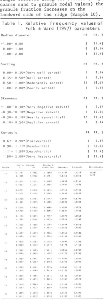
landward side of the ridge (Sample lC). Table 1. Relative frequency values of
Folk
&
Ward (1957) parametersMedium diameter
-1.00- 0.00
0.00- 1.00
1 . 00- 2.00
Sorting
0 . 00- 0 . 35*(Ver y well sort e d) 0.35- 0.50* (W e 11 s orted) 0 . 50- 1 . 00*(M o derately sorted) 1 . 00- 2.00*(P o orl y sorted)
Skewnes s
-1.00--0 . 30*(Very negat i ve skewed) -0 . 30--0.10*(Negative skewed) -0 . 30- O.IO*(Nearl y symm etrical)
0.10- 0. 3 0* ( Pos iti ve sk e wed)
Kurt osi s
0 . 67- 0 . 90*(Plat y kurtic) 0.90- I . I 1* ( Mesok urti é ) 1.11- 1.50*(Lept o kurtic) 1.50- 3.00*(Ver y leptokurtic)
l'Ied i um d i ame te r S t anda rd
Samp 1 e
•
deviation SkewrtessIA - O. 1 '81 1 .0853 0.3909 -o. O 186
- 0.1006 1. O 722 0.3401 O. O 763
IB - 0 .592 O 1.5073 0.4248 0.0698
-0.4337 1.3507 0.3654 0.1007
IC -0.873 1 1 .8316 0.3234 0.5930
0.0000 n.oooo 0.0000 0.0000
2A -0.2759 I . 2 I 07 0.6147 0.0081
-0.130) 1 .0945 0.5586 - 0.0085
2B 0.5500 0.6830 0.9)66 0.0583 0.685 o 0.6220 0.9565 0.0981
2C 0.1 150 0.92311 0.71 57 0.0870
0.1860 0.8790 0.69 3 " 0.0839
lA 1. 3255 0.3990 0.5784 -0.0408
1. 3221 0.4000 0.7812 -0.2433
lB 0.6567 0.63" 3 0.7826 - 0 . 0565
0.6965 0.6171 0.7626 -0.01311
lC 0.7978 0.5752 0.5711 5 0.0080
0.8028 0.5732 0.5710 O. o 179
4A 0.7411" 0.5969 1.3013 0.081111
0.864 o 0.511911 1 . 1087 -o. o 1 25
4, 0.7758 0.584 I 1.01113 - 0.0481
0.8297 0.5627 0.948 o -0.0745
4C 1 .26119 0.4161 0.7394 - o . 1611 7
1.2624 0.11169 0.8919 -0.3155
4D 1 .2955 0.4063 0.6315 o. o 132
1 .3065 0.4043 0.80011 - 0.155 1
10 0.2398 0.81169 t .0455 0.1 166
0.11587 0.7277 0.95110 0.0936
21 0.5869 0.6658 0.9873 0.05 I 5
0.6537 0.6357 0.9780 O. 0309
I(urtos i 5
1 . I) 18 0.95 69 0.8351
I. 1083 0. 9 306 0.0000 0.8777 , .0 50 0
1.08 7)
I. 1833
1 . 08"9 1 . 179 0 0 . 98 1) 1 .6807 0.9586 0.9"61 1 .1 2 05 I . 1 1 55 0.875 9 0 .8 16 3 I .0061 1. 082 7 1 . 1 1 1 11 1.5687 1 .0631 1 . 6612 0.8885 1.0012 0·9377 1 .0069 FR 8 3 FR 11 FR 10 FR 7 3
FR . %
2 I .43 57. 14 2 I . 43
FR. %
7. 14 7. 14 78 . 57 7 . 14
FR. %
7. 14 14.29 7 I .43 7 . 14
FR. %
7.14 50 . 00 21.43 2 I .43
Di str i b lltio n
MODENESI eta1..: Dynamics: sand-ridge: Maçaguaçu river
79
Section 2 samples show medium
diameter values (Table 1) in the coarse to medium sand intervª~; ' with
pro-gressively diminishing vªlues landward. Standard deviati~n va1ues for both sections (1 and 2) define mediumsorting, except sample lC which shows very good sorting.
The concentratiQn of coarse sand and granules observ@d in sections 1 and 2 indicates a high-energy environment for the southern part of Maçaguaçu Beach.
Section 3 samples still present coarse grains with variations of medium diameter in the opposite direction; medium diameter values increase towards the interior. from medium
(3/
A) to coarse sand (3C). Sorting is medium.Section
4
shows similar mediumdiameter values. The slight increase in the fine-sand fraction is reflected by a greater number of textural classes. Standard deviation values define medium to poor sorting grades.
Skewness values of samples from sections 1,
2
and 3 show a tendency towards symmetrical distributions; a distribution pattern cannot be dis-tinguished in section 4 samples.Kurtosis shQWS no relation to sample distributioI\.
On the sºuthern part of the beach, surface sediments are covered by some pebbles and by con~iderable amounts of whole, well~preserved shells. However,
the amount of calçium carbonate incorpo-rated into sedimentl? is small (2 to 4%) when the entire beach is considered.
As the aPove mentioned data show, a decrease in the energy leveI of
tO
transportation occurs from south to north along the beach.
Climatic conditions
On the northern par of the State of são Paulo coas tal plain, summer months are characterized by frequent, intense rainfall.
Precipitation and wind data at the time of this analysis -- December 1, 1981 to January 15, 1982 are shown in Figure 2 (Heteorological Station of the Oceanographic Institute -- USP Enseada do Flamengo-Ubatuba).
Rainfall data for January 2, 3, 4 and 5 refer to minimum values, due to registration failure.
As Figure 2 shows, two important pluvial events occurred -- from
December 6 to 9, 1981 and from January 1 to 5, 1982 -- with total precipi-tation amounts of 150 and 230 mm respectively.
Southeastern winds prevail throughout the year but, as Monteiro (1963) and Conti (1975) point out, the permanence of this pattern seems to be linked to the passage of Atlantic Polar Fronts. The pluvial events mentionned above differ in genesis. In the former, south and southwesterly winds p:revailed;
precipitation resulted from the pene-tration of maritime air masses in a post-frontal system. In the latter, southeasterly winds were constant and rainfall had a typical frontal genesis.
Wind intensity varies from weak to moderate and is practically the same during alI seasons (Conti,
op.cLt.).
80
Tides
Tidal data were collected at the Ubatuba Base of the Oceanographic Institute. The given values represent relative
levels of the tide related to the zero level of the tide gauge, hence without reference to tide base level (reduction level). No correction was made, since .. only relative variations are important.
A preliminary analysis shows tidal amplitude variations of approximately 90 cm, with mean values for high tide around 140 cm and for low tide around 50 cm (Fig. 3).
Both on December 2-5, 1981, and January 2-3-4, 1982, tidal amplitude diminished considerably to values
around 50 cm, because of higher low-tide levels (approximately 100 cm).
Although these values represent low tide levels, they are much higher than the general mean low tide levels. This fact resulted in long periods (3 days) of higher tide values.
Final remarks
Maçaguaçu beach comprises a high-energy environment. The energy level of
transportation diminishes from south to north along the beach. As an
accumu-lation feature, the sand-ridge at the moubh of the Maçaguaçu River clearly reflects these characteristics.
Q2
Fig. 3. Dai1y va1ues of tida1 amp1 itudes (Dec 81/Jan 82).
Bo1m Inst. oceanogr., S Paulo, 32(1),1983
In the period de1t with, two important pluvial events were observed together with higher tida1 cyc1es. From December 6 to 9, 1981, post-fronta1 rains occurred when the tidal cycle was a1ready at its usual1eve1s. During the second event-from January 1 to 5, 1982 -- typical frontal rains and higher tide va1ues coincided. Destructive processes took p1ace on1y during the 1atter evento
High permeabi1ity of the coarse sands of the ridge and the difference between 1agoona1 é.nd tida1 1eve1s allow fresh-water to f10w seaward through the
sediments without destroying the sand-ridge. Thus, even during periods of intense rainfall when the river's discharge increases, the 1agoon does not stand much above its normal 1eve1.
When higher lagoona1 water levf'lc; coincide with higher tidal cyc1es, the difference in heigth bctween the two 1eve1s decreases. The position of the sa1t-water wedge, which according to the Ghyben-Herzberg re1ation (Todd, 1959) exists at the intersection ' of an
aquifer with the ocean, is thus a1tered. E1evation of the fresh water-salt water interface occurs, raising f10w 1ines to the top of the sand-ridge. This rise seems to be accompanied by a decrease in volume rather than by the total inter-ruption of seaward f1ow.
Saturation with water destroys the apparent cohesion of sands (Terzaghi
&
Peck, 1948) favoring its mobi1ization. The return of tidal leve1s to normal va1ues, while 1agoonal waters remain at maximum height, resu1ts in the rapiddestruction of the ridge. Water saturated sands do not resist the pressure of lagoona1 waters.
This would be the mechanism
explaining the destruction of the sand-ridge but probably not the only one. Destructive action of storm waves during frontal passages should a1so be considered.
MODENESI uai..: Dynamics: sand-ridge: Maçaguaçu river 81
Resumo
A dinâmica de sedimentação e erosão do "spit-bar" do rio Maçaguaçu (Caragua-tatuba, são Paulo) foi preliminarmente avaliada atraves da integração de es-tudos climáticos, hidrodinâmicos e se-dimentolõgicos, considerando-se as in-ter-relaçoes das forças antagônicas entre os processos continental e marinho.
A feição construtiva do "spit-bar" parece estar conectada com a dinâmica dos processos marinhos. Suas caracte-rísticas erosionais parecem ser o re-sultado dos processos fluviais, inti-mamente relacionados aos períodos de intensa pluviosidade nas escarpas da Serra do Mar, quando da passagem de frentes atmosfericas.
Acknow ledgemen ts
We wish to thank Dr. Thomas Fairchild for revision of the English texto
References
CONTI, J. B. 1975. Circulação secun-dária e efeito orográfico na gênese de chuvas na região lesnordeste
pau-lista. Ser. Teses Monogr., Inst. Geogr. Univ. S Paulo, (18):1-82.
SUGUIO, K. & MARTIN, L. 1978.
Quaternary marine formations of the State of são Paulo and southern-Rio de Janeiro. Intern. Symp. Coastal Evolut. Quartenary, são Paulo, 55p.
TERZAGHI: K.
&
PECK, R. B. 1948. Soil mechanics in engineering practice. Ed. New York, Wiley, 566p.TODD, D. K. 1959. Ground water
hydrology. Wiley Intern. Ed., John and Sons Inc., New York, Hiley, 366 p. CRUZ, O.; SUGUIO, K. & EICHLER, B.
Influências natural e antrõpica na sedimentação acelerada de cordões arenosos atuais na Enseada de Cara-guatatuba (In press).
FOLK, R. L. & WARD, W. C. 1957. Brazos River bar: a study in the significance of grain size parameters. J. Sedim. P.etrol., 27: 3-27.
MONTEIRO, C. A. F. 1963. O clima da região sul. In: Geografia Regional do Brasil - Grande Região Sul. V. IV. Rio de Janeiro, IBGE, v.l.