Haffer, J.*
Tommesweg 60, D-45149, Essen, Germany *e-mail: [email protected]
Received January 29, 2008 – Accepted January 29, 2008 – Distributed November 30, 2008 (With 13 figures)
Abstract
The main hypotheses proposed to explain barrier formation separating populations and causing the differentia-tion of species in Amazonia during the course of geological history are based on different factors, as follow: (1) Changes in the distribution of land and sea or in the landscape due to tectonic movements or sea level fluctuations (Paleogeography hypothesis), (2) the barrier effect of Amazonian rivers (River hypothesis), (3) a combination of the barrier effect of broad rivers and vegetational changes in northern and southern Amazonia (River-refuge hypothesis), (4) the isolation of humid rainforest blocks near areas of surface relief in the periphery of Amazonia separated by dry forests, savannas and other intermediate vegetation types during dry climatic periods of the Tertiary and Quaternary (Refuge hypothesis), (5) changes in canopy-density due to climatic reversals (Canopy-density hypothesis) (6) the isolation and speciation of animal populations in small montane habitat pockets around Amazonia due to climatic fluctuations without major vegetational changes (Museum hypothesis), (7) competitive species interactions and local species isolations in peripheral regions of Amazonia due to invasion and counterinvasion during cold/warm periods of the Pleistocene (Disturbance-vicariance hypothesis) and (8) parapatric speciation across steep environmental gra-dients without separation of the respective populations (Gradient hypothesis). Several of these hypotheses probably are relevant to a different degree for the speciation processes in different faunal groups or during different geological periods. The basic paleogeography model refers mainly to faunal differentiation during the Tertiary and in combina-tion with the Refuge hypothesis. Milankovitch‡ cycles leading to global main hypotheses proposed to explain bar-rier formation separating populations and causing the differentiation of species in Amazonia during the course of geological history are based on different factors, as follow: (1) Changes in the distribution of land and sea or in the landscape due to tectonic movements or sea level fluctuations (Paleogeography hypothesis), (2) the barrier effect of Amazonian rivers (River hypothesis), (3) a combination of the barrier effect of broad rivers and vegetational changes in northern and southern Amazonia (River-refuge hypothesis), (4) the isolation of humid rainforest blocks near areas of surface relief in the periphery of Amazonia separated by dry forests, savannas and other intermediate vegetation types during dry climatic periods of the Tertiary and Quaternary (Refuge hypothesis), (5) changes in canopy-density due to climatic reversals (Canopy-density hypothesis) (6) the isolation and speciation of animal populations in small montane habitat pockets around Amazonia due to climatic fluctuations without major vegetational changes (Museum hypothesis), (7) competitive species interactions and local species isolations in peripheral regions of Amazonia due to invasion and counterinvasion during cold/warm periods of the Pleistocene (Disturbance-vicariance hypothesis) and (8) parapatric speciation across steep environmental gradients without separation of the respective populations (Gradient hypothesis). Several of these hypotheses probably are relevant to a different degree for the speciation proc-esses in different faunal groups or during different geological periods. The basic paleogeography model refers mainly to faunal differentiation during the Tertiary and in combination with the Refuge hypothesis. Milankovitch cycles lead-ing to global climatic-vegetational changes affected the biomes of the world not only durlead-ing the Pleistocene but also during the Tertiary and earlier geological periods. New geoscientific evidence for the effect of dry climatic periods in Amazonia supports the predictions of the Refuge hypothesis. The disturbance-vicariance hypothesis refers to the presumed effect of cold/warm climatic phases of the Pleistocene only and is of limited general relevance because most extant species originated earlier and probably through paleogeographic changes and the formation of ecological refuges during the Tertiary.
Keywords: Amazônia, species origin, paleogeography, river-refuge, speciation.
† The paper was re-printed in its original version. Any alteration in format, not conforming with the present rules of publishing of the Brazilian Journal of Biology is due to this republication.
Hipóteses para explicar a origem das espécies na Amazônia
Resumo
As principais hipóteses propostas para explicar as formações de barreiras separando populações e causando diferen-ciações de espécies na Amazônia são baseadas em diferentes fatores (a maioria históricos), como os seguintes: 1) Mudanças na distribuição da terra e mar ou na paisagem devido a movimentos tectônicos ou flutuações do nível do mar (hipótese Paleogeográfica); 2) o efeito de barreiras dos rios amazônicos (hipótese de Rios); 3) uma combinação de efeitos de barreiras de rios largos e mudanças vegetacionais no norte e sul da Amazônia (hipótese de Refúgio-rios), 4) o isolamento dos blocos de floresta úmida das áreas de relevo de superfície na periferia da Amazônia separadas por florestas secas, savanas e outros tipos de vegetação intermediária durante os períodos climáticos secos do Terciário e Quaternário (hipótese de Refúgios), 5) mudanças na densidade do dossel devido a mudanças climáticas (hipótese de Densidade do dossel), 6) o isolamento e especiação de populações animais em pequenas áreas montanhosas na Amazônia devido a flutuações climáticas sem maiores mudanças vegetacionais (hipótese de Museu), 7) interações competitivas entre espécies e isolamentos de espécies locais em regiões periféricas da Amazônia devido a invasão e contra-invasão durante períodos frios/quentes do Pleistoceno (hipótese Distúrbio-vicariante), e 8) especiação parapá-trica através de acentuados gradientes ambientais sem separação das respectivas populações (hipótese de Gradiente). Muitas dessas hipóteses provavelmente são relevantes para diferentes graus de processos de especiação em diferentes grupos da fauna ou durante diferentes períodos geológicos. O modelo básico de paleogeografia refere-se princi-palmente a diferenciação faunística durante o terciário e em combinação com a hipótese de Refúgio. Os ciclos de Milankovitch que levam a mudanças climáticas-vegetacionais globais afetaram os biomas do mundo não apenas du-rante o Pleistoceno mas também dudu-rante o Terciário e períodos geológicos anteriores. Novas evidências geocientíficas para o efeito dos períodos climáticos secos na Amazônia suportam as predições da hipótese de Refúgios. A hipótese de distúrbio-vicariância refere-se aos presumidos efeitos das fases climáticas frio/quente ocorridos somente no pleis-toceno e é de relevância geral limitada, pois a maioria das espécies se originam antes, provavelmente através de trocas paleogeográficas e a formação de refúgios ecológicos durante o Terciário.
Palavras-chave: Amazônia, origem das espécies, paleogeografia, teoria dos refúgios, especiações.
1. Introduction
The Amazonian rainforest faunas inhabit vast level or hilly plains from the eastern base of the Andes to the Atlantic coast at the mouth of the Amazon River, an immense forested lowland region comprising 6 mil-lion sq kilometers. During early stages of the explora-tion of Amazonia, naturalists already posed the quesexplora-tion of the origin of the innumerable species of animals that inhabit these vast rainforests. Most animal species prob-ably originated from populations that developed repro-ductive isolating mechanisms from their parent species during one or more periods of geographical separation (geographic or allopatric speciation; Mayr, 1942; 1963). Separation of populations may arise (1) from dispersal of a group of individuals of the parent species across a preexisting barrier, e.g. a river, an unsuitable vegetation belt, a mountain range establishing a founder population beyond the barrier (primary disjunction; peripatric spe-ciation) or (2) through a vicariance event fragmenting the continuous range of an ancestral species (secondary disjunction; dichopatric speciation). Whereas jump dis-persal is the mode of speciation in animals inhabiting oceanic islands and high mountain tops, most species in lowland regions of the continents probably originated through range fragmentation of ancestral species. The process of speciation is complete when a geographically separated population developed not only reproductive isolation but also ecological separation from the parent
species. In this way both became able to coexist in the same area as two different species, when they established secondary contact during later range expansion. Species at intermediate levels of differentiation are also fairly common: these species fail to hybridize but are still in-compatible ecologically in areas where they came into contact excluding each other geographically.
The origin of new species within the range of parent species without geographic separation (sympatric speci-ation) appears likely in certain fruit flies and in the case of some species flocks of freshwater fish found in tiny lakes (Schliewen et al., 1994; Gibbons, 1996; Tregenza and Butlin, 1999). However, it is still unknown whether sympatric speciation occurred more frequently in other groups of animals. My discussions below refer to the history of allopatric speciation in vertebrate animals like amphibians, reptiles, birds and mammals.
Hypotheses to e
xplain the origin of species in
Amazonia
. Biol., 68(4, Suppl.): 917-947, 2008
Table 1. Hypotheses of geographic speciation in Amazonia during the Tertiary and Quaternary periods (Cenozoic), as proposed by various authors. 1) Paleogeography hypotheses 2) River
hypothesis
3) River-refuge hypothesis
4) Refuge hypothesis
5) Disturbance vicariance hypothesis
6) Gradient hypothesis a) Island
model
b) Arch model
c) Lagoon model
Forest reduction during dry climatic periods of the past
Not considered (irrelevant) Weak; only
peripheral portions in northern and southern Amazonia affected
Strong; peripheral regions and central Amazonia affected
Weak; only peripheral portions in northern and southern Amazonia affected
Not considered (irrelevant)
Barriers separating populations
Continental seas, plateaus, flooded plains
Unknown (possibly hills and/or different egetation over arches)
Amazonian “lagoon” and widened river courses
Rivers (and their floodplains)
Broad rivers in central Amazonia and unforested areas in the headwater regions
Open forests and nonforest regions; rivers locally
Ecologically unsuitable forests
Steep environmental gradientes
Cause of barrier formation
Tectonic movements and/or sea-level changes
Surface expression of geological arches at depth
Worldwide sea-level changes
Development of rivers or dispersal of founders across preexisting river barriers
Climatic fluctuations during the Cenozoic Strong ecotones Humid/dry periods
Fairly weak Strong (also rainshadow effect due to tectonic movements)
Cold/warm periods
Time frame Tertiary Tertiary Late Tertiary– Quaternary
Quaternary Quaternary Tertiary and Quaternary
Quaternary Quaternary
Authors Emsley 1965; Croizat 1976
Patton and Silva MS (1997)
Marroig and Cerqueira MS
Sick (1967); Hershkovitz (1977); Capparella (1988)
Ayres (1986); Capparella (1991); Ayres and Clutton-Brock (1992)
Haffer (1969; 1970) Vanzolini and Williams (1970); Vrba (1992)
Colinvaux (1993); Bush (1994)
development or presence of river barriers (River theory), (3) a combination of the river effect and of climatic-veg-etational changes (River-refuge hypothesis), (4) climatic fluctuations leading to changes in the vegetation cover in portions of Amazonia (Refuge hypothesis), (5) cli-matic fluctuations leading to speciation in ecologically stable habitat pockets in the mountainous regions sur-rounding Amazonia without major vegetational changes (Museum hypothesis), (6) cold/warm climatic periods of the Pleistocene presumably leading to changes in the floristic composition of the forests and causing fau-nal changes and differentiation in peripheral regions of Amazonia (Disturbance-vicariance hypothesis). An ad-ditional hypothesis refers to current ecological (rather than historical) factors, i.e. the differentiation across steep ecological gradients due to parapatric speciation (Gradient hypothesis).
I emphasize that these hypotheses have very differ-ent relevance as speciation models for Amazonia. Highly relevant are certain paleogeography models and the ref-uge hypothesis, because they refer to a long geological time span (Tertiary-Quaternary) and to recurrent events of barrier formation. On the other hand, of relatively lit-tle relevance are those hypotheses which refer to unique historical events (e.g. the origin of the Amazonian river system) or to a relatively short geological time span (e.g. the disturbance-vicariance hypothesis which refers only to the Pleistocene, i.e. a period after most extant species had originated).
Rigorous testing of these various hypotheses or models is not yet possible in view of the lack of detailed cladistic-systematic data at the species level on one hand and the sparse geoscientific information on the history of Amazonia on the other hand. Below I discuss briefly each of the above mentioned hypotheses and some of their relative merits. In a concluding section I present several distribution maps of forest birds to illustrate sev-eral conspicuous patterns of geographical differentiation in this group of Amazonian animals.
Ecological factors that permit the coexistence of species in Amazonia include the following: Small-scale habitat mosaics due to the complex structure of the forest interior, gap phase dynamics, local topography (e.g. hill tops versus intervening valley floors) and fluvial dynam-ics (vegetation belts along river banks that change their position rapidly). The analysis of these ecological phe-nomena of local patch dynamics and disturbance cycles of the complex environment as well as of habitat pref-erence of animal species contribute to an understanding in which way the multitude of sympatric species coexist in the same rainforest region. However, in view of the insufficient spatial separation of populations inhabiting these complex habitat mosaics selectively, these ecologi-cal factors do not contribute to an understanding of the historical problems of the origin of species in Amazonia. The two distinct and largely independent sets of problems referring, respectively, to the (a) origin and (b)
coexist-ence of rainforest species, need to be distinguished in discussions of the “cause“ of tropical species richness.
2. Paleogeography Hypothesis
The changing distribution of land and sea or changes of certain physical (or ecological) surface conditions are held to have caused the separation and speciation of animal populations in Amazonia under this hypothesis. I distinguish three paleogeographic models, (a) Island model, (b) Arch model and (c) Lagoon model, that are described below.
2.1. Island model
Under this model, extant species and subspecies, as well as their distribution patterns, are thought to have originated when populations were repeatedly separated (and later reconnected) on smaller or larger islands iso-lated from one another by shallow seas due to paleogeo-graphic changes in the distribution of forested land areas and continental seas in tropical South America during the Tertiary (Figure 1a). These changes were caused by fairly gentle (epirogenic) movements, i.e. tectonic uplift or subsidence, over large regions or by more localized (orogenic) mountain building during the last 60 million years (Cenozoic era; Tertiary and Quaternary periods) and before; or these changes were caused by fluctuations of world sea-level leading to repeated flooding (and sub-sequent falling dry) of low lying areas in Amazonia and on the continental shelves. Under this hypothesis, tec-tonic movements and the formation of the surface relief in low lying and upland areas of South America (with or without sea-level changes) are considered as necessary and sufficient factors to explain the geographical isola-tion of populaisola-tions and resulting speciaisola-tion (Emsley, 1965; Croizat, 1976).
Occasional marine incursions from the Pacific Ocean and the Caribbean Sea reached western Amazonia dur-ing the Tertiary, when this region probably was mostly covered with huge lakes, swamps and river landscapes. This area was closed off from the Pacific Ocean during the Middle Miocene due to the continued uplift of the Andes mountains which eventually led to the reversal of the drainage pattern from the previous western and northwestern direction to an eastern direction. Complete continuity of the Amazon Valley to the Atlantic Ocean developed during the Late Miocene when the northern Andes were strongly uplifted (Katzer, 1903; Nuttall, 1990; Hoorn et al., 1995; Räsänen et al., 1995; Webb, 1995).
a b
c
e f
T
G
P
d
Andes 4 5
3 2
N
S
W E
Guianan and Brazilian Shields were fairly stable during the Cenozoic, although they were then gradually uplift-ed. This uplift to over 2,000 m in the Tepui mountains of southern Venezuela and in certain portions of the moun-tains of southeastern Brazil included pronounced local subsidence (e.g. the formation of narrow graben features) as well as extensive dissection of the upland regions and mountain chains. This uplift set the stage for the early evolution of the montane faunas in these regions.
Nores (1999) postulated the flooding of central Amazonia during a late Tertiary period of sea-level rise up to 100 m above present level. The Venezuelan and Guianan highlands are assumed to have been temporar-ily separated during this period and several archipelagos are believed to have developed in central Amazonia. This theory is part of the general Tertiary “island model” of faunal differentiation and needs to be considered in conjunction with the effect of other paleogeographical changes in the distribution of land and sea in Amazonia during the Tertiary. Whether or not the many species and subspecies of birds listed by Nores (l.c.) originated at the time of this supposed sea-level rise, had originated earlier or did so later in these regions will depend on fur-ther geological and DNA studies. The derivation of the upper Amazonian endemic bird species currently inhab-iting the Napo and Inambari regions near the Andes from the assumed small Pliocene archipelagos to the north and south of the upper Solimões River (if they ever existed) appears highly unlikely.
Ron (2000) and Bates (this volume) studied the areas of endemism of different vertebrate groups cladistically using Parsimony Analysis of Endemicity to produce hypotheses of area relationships. The there main clus-ters are (1) Belém, (2) Guiana and (3) Upper Amazonia (Napo + Inambari) whose origin the related to marine incursions separating these areas during the Tertiary.
Despite occasional marine incursions from the Pacific and the Atlantic Oceans into the Tertiary Amazon basin, the comparatively simple paleogeographic setting of the general Amazon region and the shield areas dur-ing that period (of ca. 60 million years duration) does not seem to provide a sufficiently complex and rapidly changing geological theater to have caused the intensive evolution, differentiation and speciation in the low-land faunas that certainly took place there during those times. The paleogeographic setting may have provided no more than the basic framework for evolution to pro-ceed. It appears likely that other factors (in addition to sea-level changes) determined the speciation patterns of the Tertiary faunas in these continental regions such as paleoclimatic fluctuations caused by Milankovitch cy-cles (see below) leading to frequent ecological vicari-ance events and the formation of temporary forest and nonforest refugia during the Tertiary (Refuge hypoth-esis; see below). Ecological refugia may form not only as a result of global climatic fluctuations but also due to fairly local tectonic movements on the shield areas (rain shadow effect).
2.2. Arch model
A number of tectonic cross elements (geologi-cal ‘ridges’ or ‘arches’) connecting the Guianan and Brazilian Shields at depth subdivide the Amazon basin into several geological subbasins (Figure 1b). Under this hypothesis, the arches are assumed to have had some (still unknown) ecological surface expression during the geological past (at least temporarily), like hilly ranges or different vegetation zones compared to the basinal regions between these arches, thereby supposedly sepa-rating the ranges of animal species and permitting their differentiation (Patton et al., 2000; Patton and Silva, this volume; Morell, 1996).
The structural arches in the subsurface of the Solimões region (Iquitos arch, Jutaí (Carauarí) arch, Purus arch) originated through tectonic movements dur-ing Jurassic time (ca. 150 million years ago). Cretaceous strata of the Alter do Chão Formation overlie unconform-ably the older (Paleozoic) sedimentary rocks or even the igneous and metamorphic basement as, e.g., over the Iquitos arch (Caputo, 1991). However, the effect of these geologically old arches on the deposition and thickness of the overlying Upper Cretaceous and Tertiary forma-tions has been very slight or negligible. This is indicated by the thickness maps for these formations published by Mosmann et al. (1986) and by the geological cross sections constructed by Caputo (1991): As illustrated on Figure 2, the overall thickness of the Tertiary Solimões Formation increases gradually in upper Amazonia from the Manaus region westward with no effect of the old structural Jutaí and Iquitos arches apparent during the last 60 million years. A slight thinning of the Upper Tertiary Pebas Formation over the former Iquitos arch is schematically illustrated by Petri and Fúlfaro (1983, figure V-5) but appears insufficient to suggest a conspic-uous surface expression in this region during the Late Miocene. However, the paleogeographic situation is still poorly known.
Colombia
Ecuador
Pacific Ocean
Lima
Bolivia
Approximate tertiary limit Márajo Trough 1,000 1,000
200 200
500 500
1,000 1,000
Basement outcrop limit
Approximate cretaceous limit Basement outcrop limit Venezuela
Tacutu Graben Tacutu Graben
Guyana
Suriname French
Atlantic Ocean
Colombia
Ecuador 200 400
500 800 1,000 1,200 1,400 2,000 3,000
Venezuela
Tacutu Graben
Guyana
Suriname
Gurupó Arch Gurupó Arch
Marajó Trough French Guiana
Atlantic Ocean
c.1. = 200 m 0 200 400 600 km 0 200 400 600 km
c.i. = 200 m
74° 66° 58° 50°
14° 10° 2°
0°
2° 0°
2°
6°
2°
0°
6°
74° 66° 58° 50°
14° 10° 500
500
5,000 5,000 3,000 3,000 3,000 3,0004,000
7,000
3,0002,000
1,000500
100
300 300 2,000 2,000
1,000 2,500
2,500
1,500 2,000
1,800 1,6001,400
1,200
400 Lima Pacific
Ocean Bolivia
Iquitos Arch
1,000
1,0001,4001,400
400 200400
400 N
S
W E
N
S
W E
Figure 2. Thickness maps of the Tertiary Solimoes Formation (above) and the Cretaceous Alter do Chao Formation (below) in Amazonia. Notice the drainage divide in central Amazonia (below Manaus) during the Tertiary and the Iquitos arch sepa-rating the Amazon basin from the sub-Andean Peruvian-Acre basin during the Cretaceous; this arch apparently was inactive during the Tertiary (Mosmann et al., 1986).
flawed on geological grounds and is highly speculative. Moreover, the position of the phylogeographic breaks of extant mammals along the Rio Juruá in western Brazil that formed the basis for this model (Patton and da Silva, 1994), approximately coincides with the border between
vegeta-tion zones rather than to the geological arches in the sub-surface. Alternatively, the phylogeographic breaks may represent zones of secondary contact between popula-tions that reestablished contact when, after a dry climatic period, dense forests returned to the Juruá region, as sug-gested by fossil mammals that inhabited a savanna-forest mosaic in this region during dry climatic periods of the Pleistocene (see below).
In contrast to the geologically old arches in the sub-surface of the Solimões region, other younger structural arches in the Andean foreland originated in conjunction with the uplift of the mountains and still today repre-sent gentle morphological surface features (Vaupés arch, Fitzcarrald arch, Serra do Moa arch; Räsänen et al., 1990; 1992). Animal species inhabiting the forests over these arches may have been partially isolated when the intervening basinal regions were flooded during humid climatic periods of the past.
A portion of the present lower Amazon Valley, i.e. the region between Manaus and Obidos, was apparently land during long periods of the Tertiary, when this area permitted a direct faunal exchange between the land re-gions of the Guianan Shield to the north and the Brazilian Shield to the south (Figure 2). Until the late Miocene, this “bridge“ was a gentle divide between the broad upper Amazonian (Solimoes) basin to the west and the comparatively small sedimentary basin under the lower-most Amazon Valley including the Marajó trough to the east (Mosmann et al., 1986). This low drainage divide disappeared during the late Miocene tectonic movements leading to the continuity of the Amazon Valley from the upper Solimões region to the Atlantic Ocean.
2.3. Lagoon model or lake model
This hypothesis is based on the assumption that most of Amazonia was covered by a huge lake or lagoon at the end of the Tertiary (Pliocene), and successively smaller portions of Amazonia were covered during a series of as-sumed high sea-level stands during the Quaternary (e.g. +70, +55, +31, +22, +9 m above present sea-level) sup-posedly documented by corresponding terrace levels in the lower Amazon Valley (Sombroek, 1966; Klammer, 1984). The proponents of this model (Marroig and Cerqueira, 1997) assume that the flooding of the Amazon basin to +180 m (and lower levels) pushed the rainforests to peripheral regions of the Amazon basin where, in ad-dition, the broadened rivers separated populations of an-cestral animals on forest “islands” (Figure 1c).
This speciation model is highly flawed for the follow-ing reasons: (1) The Belterra clays coverfollow-ing the 180 m terraces in lower Amazonia and previously interpreted as the deposits of a Pliocene “Belterra Lagoon” are appar-ently nothing but the product of tropical weathering of the underlying bedrock, i.e. residual clays (Irion, 1984a;b). Thus the Belterra clays have no paleogeographic signifi-cance whatsoever. (2) Moreover, the nine terrace levels of the lower Amazon Valley (including the 180 m level) probably have a tectonic origin and are not due to high
sealevel stands. They may be related to pulses of uplift and deposition of coarse debris from the shield areas dur-ing climatic fluctuations of the Quaternary (Clapperton, 1993:59). Therefore these terraces cannot be used as evi-dence for partial flooding of Amazonia. Global sea-level probably never rose much more than 4-6 m above its modern level during the Quaternary. The Mediterranean high shorelines of the Quaternary are also due to tectonic uplift (Clapperton, 1993). Because of these reasons the Lagoon model is untenable.
A variant of the Lagoon model envisions flooding of large parts of Amazonia to even more than 200 m above present sealevel (“Lake Amazonas”), when an Andean paleolake drained catastrophically 45,000 to 40,000 years ago (Frailey et al., 1988, Campbell, 1990). These authors assumed a dam near the mouth of the Amazon River supposedly consisting of Belterra clay that prevented the floodwaters from rapidly emptying into the Atlantic Ocean. The biogeographical implica-tions of this vast lake, if it existed, would be that porimplica-tions of the forest fauna survived the flood in relatively small disjunct pockets of rainforest located along the irregu-lar margins of “Lake Amazonas”. Tuomisto et al. (1993) critically reviewed this hypothesis concluding that it was not supported by geological field data. Räsänen et al. (1995) attributed at least part of the postulated lacustrine strata to the Miocene and Clapperton (1993) felt that this “megaflood” hypothesis should not be taken seriously. Two age dates for upper Cenozoic volcanic ash depos-its from easternmost Peru have become available (9 and 3 million years before present) and stablish approximate time constraints for the last major cycle of Cenozoic deposition in southwestern Amazonia (Campbell et al., 2001).
3. River Hypothesis or Riverine Barrier
Hypothesis
suggested that the development of the river system in Amazonia dissected once-continuous lowland forest, leading to population fragmentation and high diversity of avian species, especially in birds of the forest under-story. This basic River model of speciation appears to be flawed, because the development of the great forest and of its large rivers was probably one interrelated process. The forest cannot be envisioned without wide rivers and vice versa. The other two variants of the River hypoth-esis either refer to shifts of the location of rivers in a preexisting fluvial system or assume the active or passive dispersal of founders (individuals or groups of individu-als) across river barriers at any time after the formation of the rivers, interpreting the disjunction of populations as primary rather than secondary.
The River hypothesis in one or the other variant form has been invoked on many occasions to explain certain situations, but has never been discussed in any detail or tested on the basis of the distribution patterns of a large faunal group over the entire Amazon region. Field naturalists observed since the mid 19th century that the Amazon River and some of its tributaries separate, at least for some distance, the ranges of many forest interior species and subspecies of animals (Wallace, 1852; 1853; Bates, 1863 [for various groups of animals], Hellmayr, 1910; 1912; Snethlage, 1913; Mayr, 1942: 228; Sick, 1967 [for birds]; Hershkovitz, 1977; Ayres, 1986; Ayres and Clutton-Brock, 1992 [for primates]).
There is no question that the broad lower portions of many Amazonian rivers, often in conjunction with their much wider floodplains, effectively separate populations of many forest animals, thus causing the development or enhancement of genetic differences of the separated though still conspecific populations. This has been dem-onstrated by Capparella (1988) on the basis of his study of allozymic differences among river-separated forest bird populations. However, these genetic differences possibly disappear gradually toward the headwater re-gion of the respective rivers where the latter cease to be effective barriers and more or less uninhibited gene flow connects the broadly intergrading populations which, on the other hand, are indeed effectively separated by the wide lower stretches of the same rivers and their flood-plains (Figure 1d). Alternatively, when a wide river val-ley separates two closely related taxa, these often are in direct contact in the headwater region, where one of them crossed the narrower river course resulting in a variously extensive overlap zone (“good” species), a hybrid zone (subspecies) or in geographical exclusion of their ranges along an abrupt parapatric contact zone without hybridization (paraspecies). Such contact zones (indicating lack of geographical separation) prevent the direct application of the River hypothesis in these cases. The question is still unsolved whether the barrier effect of Amazonian rivers during the geological past has often been sufficiently effective to have caused species differ-entiation to occur in animals, or whether this isolation ef-fect in many or most cases was rather localized, leading
to the development of intraspecific differences of certain populations on opposite sides of the lower stretches of Amazonian river valleys, initiating the process of specia-tion in these cases.
Many authors invoking the River hypothesis of spe-ciation overlooked and left undiscussed the problems associated with the lack of spatial separation of popu-lations in the headwater regions. The question is not whether wide rivers are barriers to gene flow for under-story birds or whether genetic differences have evolved in populations separated by wide river courses in central Amazonia. This appears obvious (as in many popula-tions separated by other kinds of barriers on continents). Rather, the question is whether the barrier effect of rivers in Amazonia has been sufficiently effective to have led routinely to full speciation in understory birds and other animal groups (despite the lack of isolation in the head-water regions of the rivers).
I list below a number of difficulties with the River hypothesis that are usually not considered by authors fa-voring this hypothesis:
1) The frequent transfer of an extensive portion of land to the opposite side of a river each time a meander loop is cut off or a new river course carved out within the floodplain. In this way, even poorly dispersing animals of the floodplains are routinely “transported” passively across most small rivers and even large streams such as the the Rio Solimoes and the Amazon rivers.
2) The lack of geographical separation of populations in the forested headwater regions where the rivers cease to be barriers (as noted already by Wallace [1852:110]: “On approaching the sources of the rivers they cease to be a boundary, and most of the species are found on both sides of them.”) 3) A number of representative taxa of the forest
interior whose ranges are separated by rivers occupy (as uniform and phenotypically undifferentiated populations) extensive areas which are traversed by larger rivers than those that separate the ranges of these representatives. Future analyses will demonstrate whether or not such river-separated and uniform populations exhibit strong genetic differences.
4) The occurrence of numerous secondary contact zones between Amazonian subspecies and species of birds and other animals in continuous terra firme forest regions (their locations, in many cases, being unrelated to large rivers which these contact zones cross at right angles; see below). 5) The conspicuously reduced barrier effect of large
rivers during periods of lowered sea-level of the Pleistocene (by up to 130 m), when these rivers were narrower than today, flowing in more deeply incised “canyons.”
(Peres et al., 1996; Patton et al., 2000) from the Rio Juruá region in southwestern Amazonia do not support the river hypothesis of speciation but are more consistent with an interpretation of populations having established secondary contact in this region.
The problem of speciation in birds inhabiting river-created vegetation zones and in strong-flying canopy birds and other animals that readily cross broad rivers is left unexplained by the River hypothesis whose ap-plication many authors restricted to birds of the forest understory. Fjeldsa (1994: 217) dismissed the River theory concluding that “probably most of the differentia-tion happened by isoladifferentia-tion in habitat pockets along the Amazon basin periphery. As the species later dispersed, the rivers became natural ‘sutures’ between some of the sister taxa”.
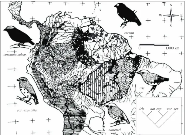
I do not mean to say that Amazonian rivers were unimportant, but they appear to have been overrated as barriers to the dispersal of sedentary animals. The broad lower courses of only a few large rivers represent effec-tive barriers to a portion of the vertebrate fauna, especial-ly species of the forest interior (many of which, however, surround the river barriers in the headwater regions). Generally speaking, the numbers of species whose ranges are delimited by rivers increase with the width of Amazonian rivers. The broad Amazon River itself, of course, is a strong barrier. Among a sample of 360 forest bird species, the upper Amazon (Rio Maranón) delimits the ranges of fewer than 20 species (Figure 3; Haffer, 1978; 1992). Going downstream this number increases along the middle Amazon (Rio Solimoes) to more than 50 species and reaches a total of over 150 species along the lower Amazon River below the mouth of the Rio Negro. The barrier effect decreases again near its mouth where large islands like Marajó, Mexiana and others facilitated increased avifaunal exchange from north to south (and vice versa) and was probably further enhanced by the repeated glacial lowering of world sealevel, when large areas of the continental shelves fell dry. The broad lower courses of the Amazonian tributary streams Rio Negro, Rio Madeira, Rio Tapajós and Rio Tocantins de-limit the ranges of 20 to 70 species in the above sample. The study of Ayres (1986) and Ayres and Clutton-Brock (1992) demonstrated that the barrier effect of Amazonian rivers for primates is comparable to that for birds. The decrease of the barrier effect of the Amazon River going upstream toward the Rio Maranón is conspicuous. On the other hand, the barrier effect for primates sharply in-creases below the mouth of the Rio Negro but dein-creases again near the mouth of the Amazon.
4. River-Refuge Hypothesis
The model that I designated River-refuge hypoth-esis (Haffer, 1992; 1993) combines aspects of the River hypothesis and of the Refuge hypothesis of faunal dif-ferentiation. Animal populations have been presumably
isolated in “semi-refugia” separated by a combination of the broad lower courses of several Amazonian rivers (plus their floodplains) and by extensive, ecologically unsuitable terrain in the headwater regions of north-ern and southnorth-ern Amazonia that were more or less un-forested during dry climatic periods when the zone of tropical forests supposedly contracted toward the equa-tor on broad latitudinal fronts (Ayres, 1986; Ayres and Clutton-Brock, 1992; Capparella, 1991). This hypothesis (Figure 1e) should not be included under the same des-ignation as the River hypothesis, because the effect of repeated climatic-vegetational changes is not required under the latter hypothesis, whereas the effect of such changes is an essential part of the River-refuge model (and of the Refuge hypothesis; see below). The Amazon forest region contracted in a north-south direction under the River-refuge model but did not fragment. Therefore, the designation “River-forest contraction hypothesis” would also be feasible for this model. However, I prefer the label “River-refuge hypothesis”, because this model is somewhat intermediate between the River model and the Refuge model and draws arguments from both. The River-refuge hypothesis was proposed on the basis of the
0 20 30 50 70 90 110 150 160
N
S
W E
patterns of distribution of Amazonian primates (Ayres, 1986; Ayres and Clutton-Brock, 1992) and a study of cer-tain bird species of the rainforest understory (Capparella, 1991).
Assuming, as a first approximation, a more or less uniform reduction of humidity and rainfall over Amazonia during dry climatic periods, this would probably lead not only to a contraction of the Amazon forest from the north and south, but would also cause the separation of upper Amazonian forest blocks from lower Amazonian forest blocks along the con-spicuous dry transverse belts that cross southwestern and central Amazonia from southeast to northwest (Figure 4; Van der Hammen and Absy, 1994; Van der Hammen, this volume). Geological data from Pitinga, north of Manaus, and from the Tapajós region (see be-low) appear to corroborate this assumption thus favoring the Refuge model over the River-refuge model.
5. Refuge Hypothesis
The Refuge model holds that species originated due to climatic-vegetational changes leading to the
separa-tion of animal and plant populasepara-tions in “refugia” and their later range expansion under the varying cool/dry to warm/humid climatic conditions of the Cenozoic (Tertiary and Quaternary periods) and before (Haffer, 1969; 1982; 1993; Vanzolini, 1970; 1973; 1992; Müller, 1973; Prance, 1973; Brown et al., 1974, Hooghiemstra and van der Hammen, 1998); see Figure 1f. There have been closed vegetation formations (forests), intermedi-ate and open formations during dry climatic periods, although the species composition of forest and nonfor-est biomes differed from today. Communities disrupted, plant and animal species changed their distributions indi-vidualistically during these climatic fluctuations at 20 to 100 thousand year time-scales (Milankovitch cycles). The number and size of refuges during the peaks of the various dry (not arid) climatic periods and the type of vegetation separating the rainforest refuges (dry forest, open forest, savanna vegetation) remain unknown. It is postulated that there have been many different periods of the formation of forest refugia and nonforest refugia on land areas due to the effects of Milankovitch cycles over the last 60 million years and before. Plant and animal populations confined to the more or less isolated forest
3,000
3,000 2,500
2,000
Tocantins Ri ver Xingu Tapajós Ri
ver Amazonas River
2,000 2,500
1,500
Orinoco Ri ver
2,000
3,000
Madeira Ri ver
Purus Ri ver
Purus Ri ver Negro Ri
ver Negro Ri
ver
N
S
W E
refugia of varying size either became extinct, survived without much change or differentiated to the taxonomic levels of subspecies or species before the unaltered survi-vors and the newly differentiated taxa came into second-ary contact with their representative populations of other refugia during a following favorable expansive phase. If at this time a refuge population had reached sexual and ecological isolation from its neighboring allies, it could disperse widely in the now-continuous habitat before its extensive range was fragmented again during the next adverse climatic phase. Some species remained more or less restricted to the areas of their origin without expand-ing their ranges widely in the continuous forest region (in this way characterizing today a number of “areas of endemism”). It remains unknown whether extinction of species or generation of species was prevalent during particular periods of refuge formation, leading to a re-duction or increase of overall regional species diversity, respectively. Newly differentiated species probably sur-vived many periods of environmental change before they speciated again.
In summary, Refuge hypothesis refers to recurrent paleoecological changes on tropical land areas over a long geological time span. Specifically, it suggests that (a) ecological conditions were not stable in tropical lati-tudes during the Cenozoic, alternating humid and dry cli-matic periods leading to continuous vegetational chang-es, (b) allopatric speciation and subspeciation of forest and nonforest faunas took place during adverse climatic periods in isolated populations, and (c) particular regions acted as areas of differentiation (“refugia”). Originally applied to the tropical regions during the Quaternary only, the theory has been extended to the Tertiary with the realization of a strong effect of Milankovitch cycles on the biomes of the world during the entire Cenozoic and before. It is likely that the climatic forcing at 20 to 100 thousand year time-scales has been a factor in pac-ing climatic change throughout Earth history. Disruption of communities due to the effect of Milankovitch cycles has been a permanent feature at 20 to 100 thousand year time-scales, although usually unrecognized because of the relatively coarse resolution of most of the paleonto-logical record (Bennett, 1997: 185). The general aspects of the refuge hypothesis challenged the earlier view that the tropics were unaffected by climatic fluctuations of the Cenozoic, the biota supposedly having differentiated exclusively due to paleogeographical changes during the Tertiary. As Morley (2000: XIII) emphasized, the “im-mense diversity [of the tropical rainforests] is due not to a long, unchanging history, with stable climatic conditions over millions of years, but to the ability of opportunistic plants to survive through periods of climatic change and geological upheaval, to expand their distributions, when changing climates permit, [and] to retreat to favorable refuges when climates were unfavourable.”
Vertebrate paleontologists studying the Great American Interchange between North and South American faunas since the closure of the Panamanian
landbridge 2.5 million years ago also challenged the ear-lier static view. They postulated instead in general terms continuity and wide distribution of rainforests in tropical latitudes during humid phases alternating with widespread savanna habitats during dry phases (Webb, 1991; Webb and Rancy, 1996). During the latter periods, four princi-pal effects influenced landscapes (Clapperton,1993): A reduced mean annual discharge of the rivers because of an overall reduction in precipitation; vertical incision and enhanced canalisation of rivers in their lower portions; a reduced vegetation cover over parts of the tropical low-lands; greater seasonality and more torrential run-off on the less protected slopes. Savanna communities ap-peared, where annual precipitation fell below 1,500 mm and a pronounced dry season existed.
During dry climatic periods of the late Tertiary - Quaternary, extensive humid forests probably survived in those regions of the Amazonian lowlands, where enough surface relief was present to create rainfall gradients, e.g. near the rising Andes, on the northeastern (windward) flanks of the Guianan highlands that were being uplifted and eroded during the Tertiary-Quaternary, as well as in Rondonia (to the north of the Parecís mountains in cen-tral Brazil) and in the hilly areas of eastern Pará (Haffer, 1969; 1974; 1982; Vanzolini, 1970; 1973; Vanzolini and Williams, 1970; Brown et al., 1974; Prance, 1982; 1996). The species composition of the faunas in forest refugia probably was not stable (compared to the region-ally more continuous rainforests during humid phases), but the refugia provided suitable habitat for lowland rainforest animals to survive adverse climatic periods. I should also mention that the complex fluvial dynamics continued to operate in the more or less extensive for-ests of the refugia. A forest refuge may not have con-sisted entirely of closed rainforest but, at least partially, of a mosaic of extensive patches of forest and savanna communities, as suggested by fossil mammals found in the upper Rio Napo region of eastern Ecuador (Rancy, 1991; 1993; Webb and Rancy, 1996). General reviews of the Refuge hypothesis as a macroevolutionary “habitat theory“ were published by Vrba (1992; 1993; 1995) who analyzed the evolutionary “turn-over pulses” of African faunas associated with climatic-vegetational fluctuations of the Tertiary-Quaternary.
geographical rainfall gradients) in combination with the effect of global climatic fluctuations during the Cenozoic are the basic factors under the Refuge hypothesis that caused ecological vicariance of vertebrate populations.
Dry forests and gallery forests probably existed in the regions between the postulated humid rainforest re-fugia, where variously extensive wooded savannas and gallery forests dominated the landscape, as suggested by fossil mammals found in the Acre region of west-ern Brazil (Rancy, 1991; 1993; Webb and Rancy, 1996; Latrubesse and Rancy, 1998) and by palynological data from the upper Rio Madeira region (Van der Hammen and Absy, 1994). Gallery forests, of course, also served as refugia for some tropical forest biotas in open regions during dry climatic phases (Meave et al., 1991; 1994). Their significance as centers of differentiation and spe-ciation, however, remains open.
The dry transverse belt that crosses central Amazonia in a NW-SE direction separating humid upper and low-er Amazonia (Figure 4) was probably the centlow-er from which dry climates spread westward and eastward dur-ing dry phases of the last several million years. Dense lowland rainforests probably disappeared from most of this dry transverse belt (Lauer 1988, Clapperton, 1993 and other authors) which includes the mountainous Pantepui region of southern Venezuela. This region had a very dry climate during glacial periods of the Pleistocene (Schubert et al., 1994; Schaefer and Dalrymple, 1995). However, small pockets of montane forest probably were preserved on high protected slopes of the tepui table mountains (collectively designated as “Pantepui refuge”§). It is inconceivable that the endemic fauna of these montane forests should have developed only in post-Pleistocene time. On the other hand, the present lowland forest fauna of the Pantepui region shows every sign of a mixed upper Amazonian and Guianan origin. Its faunal elements reestablished contact in the lowlands between the tepui mountains when lowland forests reoc-cupied these regions upon the return of humid climatic conditions.
In addition to global climatic oscillations also more localized tectonic movements led to the formation of ec-ological refugia (Haffer, 1990). In different parts of the world (Andes, Brazil, Himalayas, etc.), rising mountain ranges or subsiding basins caused climatic changes in the lowlands at the leeward sides of the mountains which led to extensive vegetational changes on a more local scale (rain shadow effect). Refugia originated for different ge-ological and paleoclimatic reasons during many periods of the history of the earth. Regarding the interaction of the degree of topographic diversity of a landscape, cli-matic fluctuations and speciation see also the discussions by Fjeldsa (1992), Vrba (1993) and Vrba et al. (1995).
§ Schubert et al. (1994) mistakenly believe that the term “Pantepui refuge” refers to relict rainforests in the tropical lowlands between the table mountains. This is a misun-derstanding. The term is applied to montane forests along the slopes of the tepui mountains in southern Venezuela.
Investigators in the tropics analyzed data sets from two independent sources - first, from geoscientific stud-ies (palynology, geomorphology, paleoclimatology, rainfall distribution in relation to the surface relief) and, second, from biogeographic studies (e.g. the mapping of areas of high biotic endemism and regions of secondary contact between closely related taxa). The coincidence between conclusions derived from these two independ-ent sets of data led to the formulation of the general hypothesis (Haffer, 1969; Vanzolini, 1970; Vanzolini and Williams, 1970; Simpson and Haffer, 1978; Haffer, 1982; Whitmore and Prance, 1987). It is incorrect when recent authors state that the Refuge hypothesis was ini-tially based on biogeographical data alone.
A number of problems with the Refuge hypothesis that need to be taken into consideration may be summa-rized as follows: (1) Large gallery forests could promote gene flow between refugia and reduce the amount of differentiation; (2) humid forests between refugia may, at times, have been replaced by dry forest (rather than nonforest vegetation); (3) geoscientific evidence only suggests that there were climatic-vegetational changes in Amazonia, not that these changes did actually cause speciation; (4) only ecologically fairly narrowly adapted forest species were affected, whereas populations of eco-logically more flexible species may not have been effec-tively isolated in the refugia.
Lynch (1988) analyzed the components of the Refuge hypothesis in a clear manner and suggested several tests or at least partial tests which, however, will be difficult to apply in view of the complexities of the geological his-tory of Amazonia and the cyclic nature of the numerous climatic-vegetational changes in the Neotropical Region. Considering the present lack of detailed knowledge of the sequence of refuge formation, even conflicting cla-distic data sets of animal groups would not, at this stage, “falsify” the model in its entirety. Generally speaking, any test of this hypothesis should be based on realistic criteria such as, e.g., that the faunal differentiation in re-fugia took place during the course of most or all of the Cenozoic and that the populations of a particular refuge reached very different levels of differentiation (subspe-cies, species) during a certain period of geographic iso-lation; or that some species remained more or less re-stricted to the area of a refuge after the return of humid climatic conditions.
lowering of the sealevel increased the areas along riv-ers forming rapids and permitting the range expansion of rheophilous species. During interglacial periods, the rising sealevel caused the retreat to and increased isola-tion of rheophilous fishes in the headwaters of the riv-ers. Other fishes may have speciated in a converse mode during periods of lowered sealevel when small popula-tions were isolated in porpopula-tions of the former riverbed and were united again, when sealevel rose and warm-humid climates returned. Two additional observations may be related to this scenario: No fish species are endemic to the floodplains of the Solimões and Amazon Rivers, all species of the floodplains being derived from forest streams, open river waters, etc. (Hamilton pers. comm.). Moreover, the decreasing amount of fossil pollen from floating meadows over the last 9,000 years (Absy, 1979) may indicate that few or no floodplains existed during the last glacial period of lowered sealevel, when the Amazon River flowed in a rather narrow deep “canyon.” Huber (1998) also hypothesized that climatic-vegetational fluc-tuations have been the major driving force for speciation in the Amazonian fish faunas during the Cenozoic, par-ticularly the cyprinodonts which he studied in detail.
The Refuge hypothesis proposes a plausible mech-anism of faunal differentiation in the tropics and in higher latitudes through the formation of ecological refugia due to Milankovitch cycles during the Tertiary and Quaternary and superimposed on a global cooling trend (see Discussion). This is a predictably reversable driving mechanism in the order of tens to hundreds of thousands of years, consistent with the rate of biological diversification (Terborgh, 1992). The refugia presum-ably served as “species traps” and “species pumps”. This historical model appears capable of explaining the ori-gin of the high tropical species diversity as compared to the less diverse faunas of the arctic and boreal biomes. The main factors are (a) the larger geographical area of tropical continents compared to continental areas in the Temperate Zones and (b) the much longer time span since the “accumulation” and diversification of species began in the tropics during early Tertiary times (and be-fore) compared to the Temperate Zones (which became temperate only during the late Tertiary global cooling trend; Shacklton et al., 1990). As a consequence, global climatic-vegetational fluctuations generated a greater number of isolated habitat fragments (refugia) during each of the many Cenozoic climatic reversals in the trop-ics than in higher latitudes. By generating more isolated populations (and thus, on average, more new species) per unit of geological time, evolution proceded “faster“ in the tropics, although the speciation process itself, of course, has always proceeded in an identical manner in tropical and extratropical faunas of the world.
The basic assumptions under the Refuge hypothesis are (1) the fragmentation of the Guianan-Amazon forests into (few to many) more or less separated humid forest blocks of different sizes during dry climatic phases of the Tertiary and Quaternary and (2) the differentiation
of animal populations isolated in these refugia. The first assumption is, strictly speaking, a geoscientific problem that will eventually be clarified by geoscientific (and palynological) data. The second assumption will have to be evaluated in detail once enough geoscientific data document the presumed fragmentation of the forests. Biological clocks giving old speciation dates do not fal-sify the mode of speciation in a refuge but falfal-sify only an assumed Pleistocene age of the event. The species under consideration may have originated in older refugia dur-ing a period of forest reduction durdur-ing the Tertiary. The Refuge hypothesis refers to a particular mode of allopat-ric speciation, but not to a particular time of differentia-tion.
5.1. New evidence for the effect of dry climatic periods in Amazonia during the quaternary
Although the data base documenting dry climat-ic periods and corresponding vegetational changes in Amazonia is still scarce, especially regarding the Tertiary, a number of interesting reports have been pub-lished in recent years (Figure 5). Additional geological and geomorphological evidence from Amazonia and oth-er portions of tropical South Amoth-erica was reviewed ear-lier by Ab’Saber (1982), Bigarella and Ferreira (1985), Haffer (1987a), Schubert (1988), Clapperton (1993), Hooghiemstra and Van der Hammen (1998), Burnham and Graham (1999) and Thomas (2000). This data,
to-N
S
W E
1 2 4 9 10 7
8
6 5
3
gether with the new results summarized below, may be considered as a geoscientific test of the Refuge hypoth-esis. It is remarkable that nearly all geoscientists who published the results of their field studies in recent years (whether they are geologists, geomorphologists, geog-raphers, palynologists, geochemists or paleontologists) agree on the basic premise of the Refuge hypothesis, i.e. a strong effect of vegetational shifts in Amazonia caused by periods of dry climates during the geological past (except Colinvaux et al., 2000). Absolute dates of many relevant deposits and events are still unknown; however, at this stage it was important to establish whether or not vegetational changes occurred in Amazonia at all. Details of mapping of past vegetation zones and dating of climatic phases will follow in later decades.
Large fossil dune fields have been discovered in the Rio Aracá-Rio Branco region of northcentral Amazonia (Figure 5, n. 9; Santos et al., 1993). The rainforests at Pitinga, ca. 250 km north of Manaus (Figure 5, n. 4) is underlain by strata that contain coarse and extremely poorly sorted layers that have been deposited under sem-iarid climatic conditions of the Late Pleistocene, when dense rainforest was absent from most of this region (Veiga et al., 1988). The same interpretation applies to portions of southern Brazilian Amazonia (Xingu, Teles Pires-Juruena, middle Tapajós and northern Rondonia; Veiga et al., 1988, Bettencourt et al., 1988, Veiga, 1991). Similarly, in the middle Rio Tapajós region (Figure 5, n. 3) and in the lowlands around the Serra do Cachimbo (Figure 5, n. 2), coarse debris accumulated in surface de-pressions during a period of strong erosion, when the late Quaternary climate was semiarid and rainforest vegeta-tion had largely disappeared from these regions (Bibus, 1983). The nature and widespread occurrence of these coarse deposits in lower Amazonia preclude their inter-pretation as being solely due to steepening of the erosion-al gradient when seerosion-alevel was low during the last glacierosion-al period, but under a humid rainforest vegetation similar to that which covers these regions today. Geomorphological observations in Rondonia (regions of Porto Velho and Humaitá; Figure 5, n. 5) by Emmerich (1988) also indi-cate a semiarid climate and open vegetation in this por-tion of southern Amazonia during the late Tertiary and during dry climatic phases of the Pleistocene. Pollen data indicate that savanna vegetation was widespread in the area to the southeast of Porto Velho, Rondonia and in other portions of Amazonia during the last glacial maxi-mum (Van der Hammen et al., 1994, Hooghiemstra and Van der Hammen, 1998; see also Freitas et al., 2001, regarding post-Pleistocene vegetational changes in this region). Throughout the Acre Subbasin (region of the upper Rio Purús and lower Rio Acre; Figure 5, n. 6), gypsum and aragonite precipitates associated with fine-grained sediments indicate the desiccation of an extensive fluvial-lacustrine system due to dry climatic conditions about 53,000 years ago, i.e. during the late Pleistocene
(Kronberg et al., 1990; 1991)¶. Moreover, paleontologi-cal studies of fossil mammals indicate that a vegetation consisting of wooded savannas and gallery forests was widespread in western Amazonia, especially in the upper Rio Juruá region, during portions of the Pleistocene be-fore dense rainbe-forests again covered this area completely (Figure 5 n. 8; Rancy, 1991; 1993; Webb and Rancy, 1996). Most of these fossil sites fall between the main postulated forest refugia (Figure 1f), but those along the upper Rio Napo in eastern Ecuador are located in periph-eral portions of the Napo forest refuge area.
The relatively small plateaus of the Serra dos Carajás, State of Pará (Figure 5, n. 1) are covered today on top with open canga vegetation and are surrounded on all sides (including the slopes) by dense rainforests. Geological and paleopollen analyses of a core collected in a swamp on one of the plateaus revealed four periods of rainforest regression from this general region during the last 60,000 years (Absy et al., 1991; however, see critical remarks by Colinvaux et al., 2000). A semi-quan-titative and dynamic approach in modelling a scenario for a “dry” climatic phase in central Amazonia below Manaus led Iriondo and Latrubesse (1994) to conclude that this region had a general savanna character and that only second-order changes in the regional dynamics are needed for the occurrence of a dry climatic phase. Based on the observation of sharp slope dissection in central Amazonia, Tricart (1974, 1985) had earlier stated that, during the last glacial stage, this region was not covered by rainforest but by drier vegetation types under which runoff was able to produce dense slope dissection.
On the other hand, a pollen record from Lake Pata in northwesternmost Brazil (Figure 5, n. 10; Colinvaux et al., 1996) confirmed the prediction of the Refuge hypothesis that this region near high surface re-lief remained densely covered with humid tropical for-ests during the last cool-dry glacial maximum (Imerí Refuge; Haffer, 1969). Serra da Neblina (up to 3,014 m) and Serra Imerí (over 2,000 m) near Lake Pata in the border region between Venezuela and Brazil certainly caused a strong rainfall gradient during dry periods of the geological past. Colinvaux et al. (1996) greatly overinterpreted their palynological results, when they claimed the Lake Pata pollen record proved that most or all Amazonia was cool and humid during the last glacial maximum. In order to test the Refuge hypothesis, sam-pling sites between (not within) postulated forest refuge regions need to be selected (see also Hooghiemstra and Van der Hammen, 1998: 157).
In upper Amazonia, coarse gravels occur within terrace sediments along the Rio Caquetá, Colombia (Figure 5, n. 7) and indicate temporary aggradational
conditions markedly more torrential than those currently prevailing along this river (Eden et al., 1982). These grav-els may be interpreted to indicate periodic phases of dry, or at least strongly seasonal, conditions in the Andean headwater region. On the basis of pollen data from the middle Rio Caquetá region, Van der Hammen et al. (1994) concluded that, during drier intervals of the mid-dle Pleniglacial, savanna-caatinga-type vegetation could develop or extend somewhat locally. Paleoclimatic data from two ice cores taken in the Andes of Peru led Thompson et al. (1995) to conclude that the Amazon ba-sin forest cover probably was markedly reduced (more patchy) during the last glacial stage than it is today.
The results reviewed above indicate strong veg-etational shifts in many regions of Amazonia due to alternating dry/humid climatic phases. In other words, the Refuge hypothesis so far withstood the test by geo-scientists (who failed to falsify its geological premises, the claims of Colinvaux et al. (2000) notwithstanding). Presently available geoscientific data are still insuffi-cient to allow for the precise mapping of changes in dis-tributions of forest and nonforest vegetation during the various climatic periods and, in particular, for the trac-ing of the size and location of areas of relictual humid forests and savannas that presumably served as refugia for the Amazonian fauna and flora during adverse cli-matic periods of the Tertiary and Quaternary. Similarly, Burnham and Graham (1999: 569-570) concluded their excellent review stating: “There are a number of indica-tions that late Glatial and early Holocene climates in the neotropical lowlands included cooler and drier intervals, and variously supported a mosaic of moist forests and drier forests to savanna-like vegetation. These are: (1) fossil mammalian faunas in Central and South America [...]; (2) a trend toward drier conditions and a more com-plex array of communities developing near the end of the Tertiary Period in Costa Rica and Panamá [...]; (3) aridity at interglacial-glacial transitions in Guatemala [...]; (4) geomorphic features suggesting aridity during the Quaternary in the Amazon lowlands [...]; (5) marked changes in sea level [...]; and (6) Quaternary aridity demonstrated from other adjacent and distant parts of the word [...]. ... The combination of temperatures ca. 6 °C cooler (during the last glacial maximum), sea level ca. 120 m lower and pollen sequences indicating a least locally habitats and open vegetation are compeling. They create at a view of lowland neotropical vegetation alter-nating between closed forest and more dry open forest or savanna-like vegetation during the environmental fluc-tuations of the late Tertiary and Quaternary Period.”
5.2. Recent discussions of the refuge hypothesis In view of much supporting geoscientific and bio-geographic evidence, numerous authors discussed the Refuge hypothesis favorably in interpretations of their own results of systematic and biogeographic studies in the Neotropics, e.g. several contributors to multi-author volumes (Duellman, 1979; Prance, 1982; Mares and
Genoways, 1982; Prance and Lovejoy, 1985; Whitmore and Prance, 1987), as well as Terborgh (1992) and Vanzolini (1992). Fjeldsa (1994: 219) concluded that Neotropical species probably “differentiate by isola-tion of relict populaisola-tions in places which remained ecologically stable, and within geologically well struc-tured regions at the periphery of an old biome” (such as Amazonia).
Reviewing geological data of the Quaternary from all over tropical South America, several geomorpholo-gists supported the basic premises of the Refuge hypoth-esis. Garner (1974: 238-239; 1975) concluded that “dry conditions with sparse vegetation invaded many humid tropical lowlands during [glacial periods] ... In effect, the lands, apart from high mountains, seem to become dry from the bottom up and moist from the top down.” Lauer (1988) and Clapperton (1993a,b) emphasized the increased dryness of the South American continent during glacial periods of the Pleistocene, when humid rainforests retreated from portions of Amazonia and were replaced by dry forests and nonforest vegetation, especially along the dry transverse belt in middle and lower Amazonia. This led to a separation of a large for-est block covering wfor-estern and southcentral Amazonia from the forests along the windward northeastern flank of the Guiana highlands. As Clapperton (1993a: 215) stated, “species of most rainforest plants and biological life would have found refuge in these areas, along with displaced populations from higher up the slopes.”
I agree with this “coarse-grained” scenario but would like to point out that the forests of southcentral Amazonia in Rondonia, and those near the base of the Andes in east-ern Peru (Inambari refuge) and easteast-ern Ecuador (Napo refuge) probably were separated, at times, from one an-other by drier types of vegetation. Moreover, additional large humid forested areas probably existed in the hilly region to the south of the mouth of the Amazon River (Belém refuge) and around the Serra da Neblina - Serra Imerí that rise to over 3,000 m a.s.l. in the border region of Venezuela and Brazil (Imerí refuge).