Delimitação de Áreas de Recarga na Bacia do Rio Sordo
Usando Isótopos de Oxigénio
Delimitation of Recharge Areas in the Sordo River Basin Using
Oxygen Isotopes
Pacheco, F.A.L.
1*, Van der Weijden, C.H.
21 Universidade de Trás-os-Montes e Alto Douro, Vila Real, Portugal 2 Universidade de Utrecht, Utrecht, Holanda
Resumo
No presente estudo, descreve-se uma metodologia para análise espacial do 18O em águas de nascente, com o principal objectivo de delimitar áreas de recarga no interior da bacia hidrográfica do Rio Sordo. A metodologia baseia-se no debaseia-senvolvimento de um gradiente isotópico nas nascentes, associado a evaporação durante o período de recarga, fenómeno esse que cresce em função do prolongamento do referido período e do gradiente térmico da bacia. O gradiente isotópico das nascentes converge com o gradiente isotópico da precipitação local, nas áreas principais de recarga. Verifica-se, na bacia em estudo, que essa convergência ocorre para altitudes acima dos 700 metros, tendo sido definidos três sectores de recarga, dois localizados nas regiões montanhosas da vizinhança da nascente do rio e um terceiro onde a bacia sofre uma alteração morfológica acentuada representada por uma redução significativa da largura do vale principal. A maioria das nascentes localiza-se fora das zonas de recarga definidas anteriormente. Embora se preveja que algumas nascentes possam ser reabastecidas a partir dessas áreas, representando nesses casos pontos de saída de circuitos hidráulicos regionais ou intermédios, considera-se que na maior parte dos casos a recarga se processa a partir de zonas de recarga locais posicionadas nas imediações da emergência.
Palavras-chave: área de recarga, evaporação, isótopos de oxigénio, nascentes, precipitação.
Abstract
This study describes a methodology for spatial analysis of 18O in spring waters, having as main objective to delimit recharge areas within the Sordo River basin. The method is based on the development of an isotope gradient in the springs, associated with evaporation during the recharge period, a phenomenon that grows on the prolongation of this period and on the thermal gradient of the basin. The isotopic gradient of the springs converges with the isotope gradient defined for local rainwater, in the main recharge areas. For the studied basin, this convergence occurs for altitudes above 700 meters, having been defined three recharge sectors, two located in the mountainous regions of the river source and a third where the basin undergoes a dramatic morphological change represented by a significant reduction in the width of the main Valley. Most of the springs are located outside of recharge zones defined previously. Although it is expected that some springs can be refilled from these areas, in which case they represent outlet points of regional or intermediate hydraulic circuits, in most cases the recharge will take place from areas positioned in the vicinity of the spring site.
Keywords: evaporation, oxygen isotopes, rainfall, recharge area, springs.
INÍCIO
Introduction
Isotopic analyses of oxygen have been used to estimate mean recharge elevations of springs in several catchments of mountainous areas (James et al., 2000; Oliveira and Lima, 2007; Jeelani et al., 2010). In general, these areas are characterized by a vertical isotopic gradient describing the depletion of 18O in precipitation
water per 100 m rise in topographic elevation. Because springs are usually recharged at the higher elevations of the catchments, spring waters will also be depleted in 18O, although they
emerge at lower altitudes. The equation for the isotopic gradient combined with the 18O values
in the spring waters give an extrapolation for the mean recharge elevation of the springs. Besides, the spatial relation between recharge cells and spring sites can be used to draw a flow path between the two points.
Evaluation of the mean recharge elevation by extrapolation, using the vertical isotopic gradient of precipitation water, assumes that evaporation is limited during the period of recharge. This may comply with cases where rock massifs are highly permeable and hydraulic gradients are extreme (e.g. flow through karstic aquifers or along the saprolite horizon), or where temperatures during the recharge period are so low that evaporation is reduced to a minimum. But it may fail when recharge takes place in low permeability rocks such as granites or metassediments, located in regions of temperate climate. Evaporation effects based on interpretation of 18O patterns
have been reported in many studies over the last six decades (Zimmerman et al., 1967), Ingebritsen et al., 1994; Leontiadis et al., 1996; James et al., 2000; Schiavo et al., 2009; Negrel
et al., 2011; among others).
When rain falls over a low permeability medium, water remains for variable periods of time at the recharge cells to ensure the replenishment of local, intermediate and regional flow circuits. Continuation of water at the recharge cells enables evaporation and consequently the enrichment of spring waters in 18O. Usually, longer / deeper circuits require wider time spans for recharge than shorter / shallower circuits. These time differences define a relationship between distance from the recharge area and
18O enrichment in spring water, called isotopic
gradient of spring waters. Additional to the effect of variable recharge time is the recharge at variable altitudes. Although watersheds have main recharge areas located at the catchment’s source area, springs may also be recharged by local flat areas situated at lower elevations. Evaporation at these local recharge areas is higher than at the main recharge area, because temperatures are also higher. If local recharge areas are well distributed within the watershed, the increase in evaporation towards lower elevations will cause another 18O gradient in spring waters. The purpose of this study is to combine the isotopic gradients of spring waters
with the isotopic gradient of precipitation water to delineate the main recharge areas of a mountainous catchment situated in the Hesperic basement of Northern Portugal, and to understand the hydraulic pathways of spring waters blooming from that watershed.
Study Area
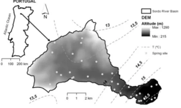
The study area comprises the hydrographic basin of Sordo River. This watershed is located in the province of Trás-os-Montes and Alto Douro (North of Portugal) and occupies an area of approximately 50 km2, from a minimum altitude of 215 meters to a maximum of 1290 m. The western part of the basin is characterized by a wide open basin surrounded by mountain hills. In the eastern part, the main water course crosses a valley with very steep slopes. For that reason, the western part has an average width of approximately 8 km whereas in the eastern part that width shrinks to no more than 1.5 km. The basin is shaped on Hercynian granites (eastern part) and Palaeozoic metassediments (western part), the latter covered by modern alluvial deposits in a sector of the central valley (Pacheco and Alencoão, 2006). Mean annual temperatures range from 13ºC in the highlands and 15.5ºC in the valleys close to the river’s mouth (Fig. 1).
Fig. 1 – Geographic setting and topography of the Sordo river basin. Location of sampled spring sites. DEM – Digital Elevation Model; T – mean annual temperature.
The Sordo River is a tributary of the Corgo River. The catchment of the Corgo occupies an area of approximately 290 km2. For this
watershed, Alencoão and Pacheco (2006) coupled water balances with rainfall-runoff regressions to calculate infiltration (R) and groundwater discharge (Qg) on a monthly basis.
The results, integrated on a yearly basis, demonstrated that Qg R. This result is typical
for basins that are closed to flow, where recharge derives from areas positioned within the catchment’s boundary.
The spatial variability in isotopic composition (2H and 18O) of Northwest Iberian modern
studied by Oliveira and Lima (2010). Altitude, continental, and latitude effects can explain depletion in heavy isotopes, when water masses move from the Atlantic coast eastwards. On average, altitude leads to a depletion of 0.17‰ in 18O per 100 meter rise. The decrease in 18O
values, as the distance from the coast increases, defines an inland isotopic gradient of about 0.1‰ in 18O per 10 kilometre. A gradient of
0.55‰ was estimated for 18O between 41º
and 44º latitude north. Altogether, the altitude and continental effects account for 78% of the
18O variability in regional precipitation.
The spatial distribution of 18O in the
hydrographic basin of Sordo river is illustrated in Fig. 2. The contours were drawn from data in Oliveira and Lima (2010). As would be expected from the reported altitude effect, in the basin there is a general depletion in the 18O from the
lowlands (18O = 5.86‰) towards the highlands
(18O =6.18‰). However, the local gradient,
considering the range of altitudes within the basin (2151290 meters; Fig. 1) is solely 0.03‰, much lower than the regional gradient.
Fig. 2 – Spatial distribution of the 18O (precipitation water) in the Sordo river basin. Original data compiled from Oliveira and Lima (2010).
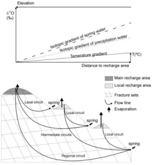
Conceptual Model
In temperate climates, the late autumn to early Spring seasons are characterized by a water surplus which, depending on the ground topography, is converted into surface runoff, evaporation and recharge. In the flatter areas of the catchment, especially at the highlands and during the winter season, recharge will be the dominant process. The water surplus is first stored in local cover soils and saprolites and, when these materials are saturated and the field capacity has been exceeded, infiltration begins and percolation across the fracture networks starts its course. Percolation at shallow depths (local circuits) is relatively fast because rocks in the upper horizons are moderately disaggregated showing increased permeability. For that reason, water is rapidly drained from the concomitant recharge sites and consequently evaporation is expected to be low around these sites. Conversely, to replenish intermediate or
regional circuits, water must remain longer periods in the corresponding recharge cells, because flow lines in these cases cross deeper and hence more compact and less permeable sectors of the fractured massif. These wider time spans potentiate the development of evaporation and therefore the enrichment of recharge water in 18O, evaluated downstream at spring sites.
Due to this enrichment, it is expected a positive correlation between 18O and distance to
recharge area. Since recharge areas are located at highlands and the spring sites within the lowlands, it is also expected a negative correlation between 18O and elevation.
In general, recharge in mountainous areas occurs at the highest altitudes around the catchment’s source. These areas are called main recharge areas. However, there are other places within the basin where conditions for the occurrence of recharge are also met, determined by the local water balance. These places are called local recharge areas and comprise flat regions of the watershed. The extent of evaporation in local recharge areas is conditioned by the temperature gradient of the basin. It will be minor in areas with a high elevation and maximum at the lowlands. In keeping with this trend, a progressive enrichment in 18O is expected for spring waters
emerging towards the lower altitudes.
The conceptual model described above is illustrated in Fig. 3. In this sketch, a catchment shaped on a fractured massif is represented with a main and two local recharge areas, and with local to regional flow circuits.
Fig. 3 – Expected isotopic gradients in precipitation and spring water in areas where evaporative processes take place before infiltration.
Due to a relatively prolonged residence time in the main recharge area, water may evaporate prior to infiltration increasing the 18O of spring
isotopic gradient for the spring waters (dashed line). Contribution to this trend may also come from amplified evaporation at the local recharge areas. Because of an altitude effect, a similar gradient is also developed for precipitation water (dotted line), here represented with a lower slope. Regardless the slopes of the two lines, they are expected to converge towards the main recharge area and diverge in the opposite direction. This area will be defined by the sectors of the catchment where 18O (precipitation)
18O (spring) = 0.
Fig. 3 indicates that springs may be replenished by the main recharge area, by local recharge areas, or by both. It is expected that the 18O of
springs recharged by a single local recharge area show a firm correlation with temperature, as in these cases the isotopic gradient of the spring waters is exclusively determined by the temperature gradient of the basin. It is however beyond the scope of this study to describe the full relationship between the isotopic composition of the springs and their specific hydraulic pathways.
Materials and Analytical Techniques
Samples of baseflow spring water were collected in late September 2010 for isotopic analysis of
18O and 2H. The location of the spring sites is
indicated in Fig. 1. The hydrogen and oxygen stable isotopes of H2O were measured on a
Thermo Gasbench-II coupled to a Finnigan MAT-253 (cf. Nelson, 2000).
Results and Discussion
The relationship between 18O and 2H in the
sampled spring waters is illustrated in Fig.4. The Global Meteoric Water Line (GMWL; Craig, 1961) and the Local Meteoric Water Line (LMWL; Oliveira and Lima, 2010) are also represented in the figure.
Fig. 4 – Plot of 18O versus 2H for the sampled spring waters. GMWL is the global meteoric water line (2H = 8 18O + 10). LMWL is the local meteoric water line (2H = 7.69 18O + 8.96) defined by Oliveira and Lima (2010).
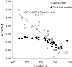
All spring waters fall below the LMWL, suggesting that evaporation occurred in the recharge areas of the springs prior to infiltration. Similar plots and interpretation are reported in various studies (e.g. James et al., 2000; a references therein). The extent of evaporation was variable because the distribution of the black dots is highly patchy. Resulting from evaporation, an isotopic gradient has been developed, represented in Fig. 5 by a negative correlation between 18O in spring water and
elevation, expressed by a depletion of 0.15‰ in
18O per 100 meter rise in topographic elevation.
The relationship between 18O in precipitation
water and elevation is also represented in the figure. The 18O values in this case were
extrapolated from Fig. 2, considering the location of the spring sites (Fig. 1). Apparently, the altitude effect at the spring sites is noticeable solely for elevations higher than 700 meters. Above this altitude, circles and black dots converge towards similar values, meaning that the main recharge area of the basin would be located beyond this threshold.
Fig. 5 – Plot of 18O versus elevation for the sampled spring waters and in precipitation. The 18O values for precipitation were extrapolated from Fig. 2, considering the location of the springs (Fig. 1).
The spatial distribution of 18O in spring waters
is illustrated in Fig. 6. As would be expected, depletion in 18O is more pronounced near the
source area, where the 18O values are vary
from 6.1‰ to 6.3‰. This range of values reappears in a small sector where the basin is narrow, while in the flat and wide central valley
18O is relatively constant, approaching 5.9‰.
Eventually, the morphologic characteristics of this valley justify the conservation of 18O
between the altitudes of 300 and 600 meters, as indicated in Fig. 5. Towards the lower elevations, spring waters become more enriched in the heavy isotope, assuming values of 18O in the
range 5.1‰ to 5.3‰. The differences between
18O in precipitation water and in spring water
(Fig. 3), one would expect a maximum value of zero for this difference, representing the centroid of the main recharge area where isotopic gradients of precipitation and spring water converge. However, it must be recognised that there are uncertainties in the 18O estimated for
precipitation, because these values were extrapolated from a regional scale (Fig. 2). On the other hand, isotopic values of precipitation refer to mean weighted values of the period 20042006, whereas for spring waters these values refer to a single measurement, made in September 2010. In view of such uncertainties, the main recharge area of the Sordo River basin was assumed for values 18O (precipitation)
18O (spring) 0. The areal representation of
this inequality is illustrated Fig. 7. As indicated, the main recharge area of the Sordo River basin is composed of three sectors, two of them located at the catchment’s source area, to the North and to the South of the main water course, between the altitudes of 800 and 1200 meters. An additional sector is positioned at an average elevation of 700 meters, to the South of the main water course and to the East of where the wide central basin narrows, being replaced downstream by a valley with a V shape and very steep hillsides. It is not plausible that areas located outside the watershed can contribute with recharge, since the parent watershed (Corgo River basin) was assumed a closed flow basin (Alencoão and Pacheco, 2006).
Fig. 6 – Spatial distribution of 18O in spring waters, within the Sordo River basin.
Fig. 7 – Spatial distribution of main recharge areas within the Sordo River basin.
Some of the springs are located in sectors of the main recharge area. In these cases, it can be
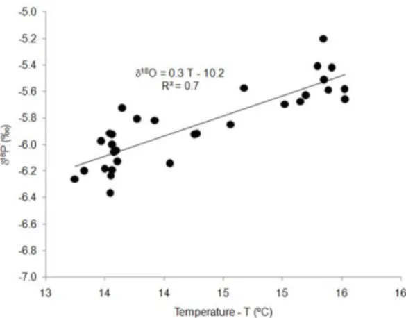
assumed that hydraulic pathways are short and shallow, i.e. that spring waters flow along local circuits. But most spring sites fall outside the boundaries of the shaded areas in Fig. 7, meaning that, in a first glance, they can be the outlet of local, intermediate or regional circuits (Fig. 3). The plot of 18O in spring water versus
air temperature is shown in Fig. 8. There is a marked correlation between the two variables, indicating that the temperature gradient of the basin influences the isotopic composition of the spring waters, and therefore that the vast majority of spring sites should be replenished by local recharge areas. However, given the scatter in Fig.8, association of at least some of the spring sites to intermediate or regional circuits cannot be discarded.
Fig. 8 – Plot of 18O as a function of temperature. The correlation between these variables suggests that spring sites are mostly replenished by local recharge areas.
Conclusions
Isotopic patterns of 18O have been used to
draw main recharge areas within the boundaries of the Sordo River hydrographic basin. In this watershed, spring waters are enriched in 18O
due to evaporation at local recharge areas. Evaporation increases towards lower altitude recharge areas because of the basin’s temperature gradient. The isotopic pattern developed by such progressive evaporation converges with the isotopic gradient recognised for precipitation water, at altitudes above 700 m. Elevations beyond this threshold are therefore part of the main recharge area. Three sectors of the basin were found to define this area. Two of them are positioned at the catchment’s source, a third one occupies an elevated region located where the main valley changes from a wide open basin to a V shaped valley with steep hillsides. Spring waters show a marked correlation between 18O and temperature (T),
suggesting that they are fed by local recharge areas. However, the 18O versus T relationship
is represented with quite some scatter, suggesting the affiliation of some of the springs to intermediate or regional hydraulic circuits.
References
Alencoão, A. M. P., Pacheco, F. A. L., 2006. Infiltration in the Corgo river basin (north of Portugal): coupling water balances with rainfall-runoff regressions on a monthly basis. Hydrologic
Sciences Journal, v. 51, p. 989-1005.
Craig, H., 1961. Isotopic variations in meteoric waters.
Science, 133, 1702 .
Ingebritsen, S.E., Mariner, R.H., Sherrod, D.R., 1994.
Hydrothermal systems of the Cascade Range, north-central Oregon. US Geol. Surv. Prof. Pap., 1044-L, 86p.
James, E.R., Manga, M., Rose, T.P., Hudson, G.B., 2000. The use of temperature and the isotopes of O, H, C, and noble gases to determine the pattern and spatial extent of groundwater flow. J.
Hydrology, 237, 100–112.
Jeelani, Gh., Bhat, N. A., Shivanna, K, 2010. Use of
8O tracer to identify stream and spring origins of a mountainous catchment: A case study from Liddar watershed, Western Himalaya, India. J.
Hydrology, 393, 257–264.
Leontiadis, L., Vergis, S., Christodoulou, Th., 1996. Isotope hydrology study of areas in eastern Macedonia and Thrace, northern Greece. J.
Hydrology, 182, 1–17.
Negrel, Ph. Pauwels, H. Dewandel, B. Gandolfi, J.M. Mascré, C. Ahmed, S., 2011. Understanding groundwater systems and their functioning through the study of stable water isotopes in a hard-rock aquifer (Maheshwaram watershed, India). J. Hydrology, 397, 55–70.
Nelson, S.T. (2000). A simple, practical methodology for routine VSMOW/SLAP normalization of water samples analyzed by continuous flow methods.
Rapid Commun Mass Spectrom, 14, 1044–1046. Oliveira, A. C. V., Lima, A.S., 2010. Spatial variability
in the stable isotopes of modern precipitation in the northwest of Iberia. Isotopes in Environmental
and Health Studies, 46(1), 13–26.
Pacheco, F.A.L., Alencoão, A.M.P. (2006). Role of fractures in weathering of solid rocks: narrowing the gap between experimental and natural weathering rates. J. Hydrology, 316, 248265. Schiavo, M.A. Hauser, S. Povinec, P.P., 2009. Stable
isotopes of water as a tool to study groundwater– seawater interactions in coastal south-eastern Sicily. J. Hydrology, 364, 40–49.
Zimmerman, U., Ehhalt, D., Munnich, K.O., 1967. Soil water movement and evapotranspitation: change in the isotopic composition of the water. In:
Isotopes in Hydrology. IAEA, Vienna, pp. 567– 585.