Edited by
Delminda Moura, Ana Gomes, Isabel Mendes & Jaime Aníbal
CiMa
GUADIANA RIVER ESTUARY
Title:
GUADIANA RIVER ESTUARY. Investigating the past, present and future
Editors: Delminda Moura Ana Gomes Isabel Mendes Jaime Aníbal Cover image
Aerial photo of the Guadiana River estuary (July 14, 2010) Credits: Tomasz Boski (CIMA)
Graphic Design:
Grácio Editor
1st Edition: August 2017
ISBN: 978-989-8859-18-1
To cite a chapter of this book:
Name of the author/s (2017). Title of the chapter. In: Moura, D., Gomes, A., Mendes, I. & Anílbal, J. (eds.), Guadiana River estuary - Investigating the past, present and future. 1st edition. University of Algarve. Faro, ISBN 978-989-8859-18-1, pp. pages of the chapter
Persistent identifier: http://hdl.handle.net/10400.1/9887 © Centre for Marine and Environmental Research (CIMA) University of Algarve, Portugal
4. The Continental Shelf off the Guadiana estuary
Isabel Mendes
1& Francisca Rosa
1, 21Centre for Marine and Environmental Research, University of Algarve, Campus de Gambelas, 8005-139
Faro, Portugal
2PetroStrat – Applied Stratigraphy Ltd., Tan-y-Graig, Parc Caer Seion, Conwy, LL32 8FA, North Wales, UK
[email protected]; [email protected]
4.1. What defines and characterizes the continental shelf off the guadiana estuary?
4.1.1. Geographic location
The Continental shelf is the seafloor area around a large land mass where the sea is relatively shallow compared with the open ocean. This major physiographic domain is comprised between the shoreline and the shelf break located at variable water depths (generally, around 200 m water depth) and variable extensions (average width of about 80 km).
The continental shelf off the Guadiana estuary is the area in front of the Guadiana River mouth, which is influenced by the discharges of the Guadiana River Basin. This area is located in the southern border between Portugal and Spain, in the middle part of the northern Gulf of Cadiz continental shelf, southwestern Iberian Peninsula (Figure 4.1).
Figure 4.1.
4.1.2. Shelf Geomorphology
The maximum extent of the northern Gulf of Cadiz continental shelf occurs on the middle part, and decreases laterally both towards Cape São Vicente and the Strait of Gibraltar. The shelf has a minimum width of 5-7 km off Cape Santa Maria, increases to 20-25 km off the Guadiana River and attains a width of more than 30 km off the Guadalquivir River mouth (Figure 4.1). Accordingly, the mean slope of the Portuguese shelf is 0.5°, decreasing to slopes of less than 0.3° on the Spanish shelf. The average Guadiana shelf slope is 0.32°.
The shelf break lies at varying water depths in concordance with shelf width and slope changes. Off the Guadiana River, the shelf break lies at around 140–150 m water depth. The shelf can be divided here into three main morphological provinces, namely the inner shelf (from approximately 0 to 30-50 m water depth), the middle shelf (from 30-50 to 90-100 m water depth) and the outer shelf (from 90-100 to 140-150 m water depth) (Figure 4.2).
Figure 4.2.
Schematic morphology of the continental shelf off the Guadiana estuary, with the identification of the morphological zonation, inner, middle and outer shelves.
4.1.3. Climatic characteristics
What are the main characteristics of the climate in the Guadiana Valley region?
The Iberian Peninsula is located in a transitional climatic region where Atlantic and Mediterranean influences meet and imprint specific low-frequency variability patterns to the regional climate.
The climate that characterizes the Guadiana Valley is however of strong Mediterranean influence, as the Guadiana River drains a semi-arid region and its runoff shows high intra- (i.e. seasonal) and inter-annual variability. The mean annual rainfall along the hydrological year is distributed by three different periods: rainy (October-February), transitional (March-May) and dry (June-September).
What is the North Atlantic Oscillation (NAO) and how does it influences the regional climate in the Guadiana Valley?
The general climate trends in the region are strongly determined by the North Atlantic Oscillation (NAO), which is the leading pattern of climate and winter surface variability over the North Atlantic (Figure 4.3).
In general terms, the NAO refers to a redistribution of atmospheric masses between the Arctic and the subtropical Atlantic basin, and shifts from one phase to another, positive and negative, producing large changes in surface air temperature, winds, storminess and precipitation over the Atlantic (Figure 4.3). Positive values of the NAO index are typically associated with stronger-than-average westerlies over the middle latitudes, and wetter/milder weather over western Europe, whereas negative index values usually associate with stronger westerlies and enhanced moisture over low-latitudes and the Mediterranean (Figure 4.3).
4.1.4. Oceanographic regime
Tides and waves
The continental shelf off the Guadiana River is considered mesotidal with a mean tidal range of 2 m. Wave energy is moderate with an average annual significant offshore wave height of 1.0 m and average peak period of 8.2 s. The offshore waves are predominantly incoming from the west-southwest (71% of occurrences) to east-southeast, but easterly “Levante” winds frequently generate short-period waves incoming from the southeast (23% of occurrences) in direction to northwest-west. Storm events in the region have been defined as events with offshore wave heights superior to 3 m, between 1986 and 1993, storm events accounted for 1% of the offshore wave climate.
Shelf current patterns
In the Gulf of Cadiz the shelf circulation patterns are complex, showing different behavior in the open sea and on the continental shelf. The general surface circulation is anticyclonic, which is quasi-permanent in the open sea but interrupted on the continental shelf on a seasonal basis. Thus, the surface spring-summer circulation is governed by a branch of the larger-scale Portuguese-Canary Eastern Boundary Current (core N2), which moves around a cyclonic eddy off Cape San Vicente (SVE) and moves further east towards the Strait of Gibraltar to feed the Atlantic inflow into the Mediterranean. To the east, the shelf is dominated by a cyclonic circulation bounded by a shelf-break front (core N1) at the south and a warmer
Figure 4.3.
Model of the two modes of the North Atlantic Oscillation (NAO), associated storminess activity and distribution of moisture over the North Atlantic: a) negative and b) positive NAO index phases. H – Subtropical High Pressure Centre, L – Icelandic Low Pressure Centre (adapted from http://www.ldeo.columbia.edu/res/pi/NAO/).
coastal countercurrent (CCC) in the northern area (Figure 4.4). During the late autumn-early winter flow reversals and the eastward current replaces the cyclonic circulation (core N1). A likely closure of the cell could occur as the inflow from to the Strait of Gibraltar from the interior of the Gulf of Cadiz.
The dynamics in this area is also strongly dependent on wind regime. Westerly winds enhance the
upwelling off Cape São Vicente (an almost-permanent phenomena in this area), creating a second intense core of upwelling off Cape Santa Maria and extending the upwelling along the southern Portuguese coast. Easterly winds favor the warm coastal countercurrent that is observed in the eastern shelf and may invade the western shelf connecting both shelves in an east to west direction. The relaxation of the large-scale upwelling favorable wind also drives the development of this coastal countercurrent.
4.1.5. Sediment supply and main sources
Sources of sediment to the Guadiana Continental Shelf
The main regional sediment source is the Guadiana River. The sediment supply from the river basin is dominated by suspended load relative to bed load material, and shows strong seasonal and inter-annual variability. The river discharges more sediment (both coarse- and fine-grained) onto the shelf during winter floods generated by intense rainfalls. On the contrary, persistent drier years mean less precipitation during winter seasons and less amounts of sediments being transported from the river basin to the shelf. The second most important regional source to the shelf is the littoral drift, a mechanism of bed load transport. The longshore transport of sandy sediments is eastward-directed under the predominant influence of the south-eastward Atlantic currents, which move along the southern Portuguese coast towards the eastern sector of the Gulf of Cadiz.
Figure 4.4.
Schematic surface circulation on the Northern Gulf of Cadiz. Grey lines correspond to the spring-summer circulation (adapted from García-Lafuente et al., 2006). Black lines indicate the open sea autumn-early winter circulation (adapted from Criado-Aldeianueva et al., 2009). Legend: N2- branch of the larger-scale Portuguese-Canary Eastern Boundary Current; SVE- cyclonic eddy off Cape san Vicente; N1- cyclonic circulation bounded by a shelf-break front; and CCC- coastal countercurrent.
What do we know about the current distribution patterns of sediments on the Guadiana shelf and the main mechanisms behind it?
Most of the river’s bed-load sediment that is exported to the shelf is deposited in the inner shelf at around 15 m water depth. The exported sediments constitute a submerged sandy delta with some patches of sandy muds, reflecting the combination of both fluvial and littoral drift sources. The fine-grained fluvial sediments tend to be re-suspended on the inner shelf by currents and storms.
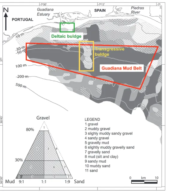
Sands dominate the surficial sediments on the inner shelf down to water depths of ca. 25 m (Figure 4.5). The middle shelf is dominated by very fine silt and clay deposits that form the Guadiana mud belt, extending from ca. 30-40 to 90-100 m water depths (Figure 4.5). This deposit is mainly fed by the resuspension of inner shelf fine-grained sediments.
East of the Guadiana River Mouth, these muddy deposits are interrupted by an N-S oriented coarse-grained (i.e., muddy gravelly sands) deposit of transgressive origin (transgressive buldge) stretching from ca. 20 to 100 m water depth (Figure 4.5).
In the outer shelf the surficial sediment distribution exhibits a complex mosaic of sands and silty clays, with patches of sand and gravelly sands near the shelf edge (Figure 4.5).
Figure 4.5. Modern distribution of surficial sediments on the Guadiana Shelf (sediments of type 1 and 4 do not occur on the mapped area). Classification of sediments according to Folk (1954) (Adapted from González et al., 2004).
Distributional patterns of the mineralogical and biogenic components of sands: clues to understand the origin of the shelf sediments
Most of the inner shelf sands are dominated by terrigenous/mineralogical components, largely quartz. Bioclasts (e.g. mollusc and gastropod shells, foraminifera, echinoids) can form large accumulations locally. In the vicinity of the Guadiana mouth, fluvially-supplied terrigenous particles and mollusk shells settle down up to ca. 5 m water depth whereas micas (mineral) settle around 10-15 m water depths. Other terrigenous particles such as fluvially-derived metaschists and greywacke (rock types) grains are very abundant on the deltaic bulge (deposits composed of a mixture of sands and mud that accumulate on the inner shelf, just in front of the Guadiana River mouth) (Figure 4.5).
Most of the middle and outer shelf sands are composed of bioclastic grains. Foraminifera dominate but locally, on the outer shelf, large amounts of mollusc shells are present, particularly in the transgressive bulge. Quartz is the dominant component of the sandy fraction in the mud belt in front and east of the Guadiana River mouth, down to ca. 90 m water depth (see Box 4.1.).
4.1.6. Anthropogenic impact
The impact of anthropogenic land-use activities on the environment has been widely investigated throughout Europe in recent years; a relationship between human forcing mechanisms and the
transformation of the natural systems has been evidenced.
In southern Iberia, the influence of human activity on the landscape has been detected as far back as ca. 5,500 cal. years B.P. Particularly, the onset of exploration of the Iberian Pyrite Belt is dated around the third millennium B.C.
The first indications of human modification of the vegetation cover and of mining exploitation in the Guadiana Valley also date back to around 4,500-4,000 cal. years B.P. Subsequent transformations were driven by the emergence of a semi-forested cultural landscape and the intensification of mining practices after ca. 3,300 cal. years B.P.
Major landscape changes were brought by the Roman Rule of Iberia (ca. 200 years B.C. to 500 years A.D. – ca. 2,200 to 1,450 cal. years B.P.). Indeed, historical and archaeological sources record an increased exploitation of vegetation and woodland resources during this period, for agricultural, domestic and larger-scale mining purposes. These activities favoured widespread soil erosion; which was contemporaneous with a climate change to wetter conditions, thus producing an increase of the sediment flux to the coast.
The Medieval Islamic Rule of Iberia, after the 8thcentury A.D. (ca. 1,200 cal. years B.P.), constituted the
second major pulse of human intervention in the Guadiana River Valley.
An unprecedented population growth let to an extraordinary maximization of the natural resources of the region, which eventually exacerbated the ongoing erosional processes.
Throughout the Middle Ages and beyond, the human-induced transformations persisted to some extent, although another significant increase of such activities only occurred during the last ca. 200-150 years. The reactivation and expansion of several important mines along the Iberian Pyrite Belt during the 19th
century A.D., including the São Domingos Mines in the south of the Alentejo region, and new agricultural
Box 4.1. Did you know that…
The Measurement of average Guadiana River flows at Pulo do Lobo Hydrographic Station (Lower Alentejo), which covers 91% of the Guadiana River drainage basin, have witnessed a dramatic reduction in the second half of the 20thcentury, decreasing to nearly half the
values.
The main reason behind this change in the water-flow volume in the river basin was the construction of several dams and the
development of intensive irrigation schemes, both on the Spanish and Portuguese sides of the border.
developments such as the Wheat Campaign during the 1930s, contributed to the enhancement of the long-term anthropogenic impacts in the region. Consequently, soil erosion increased along the watersheds and the sediment supply from the river basin to the coast and shelf increased.
4.2. how can we learn about the evolution of the continental shelf?
4.2.1. Knowing the present conditions
Present-day environmental conditions must be understood in order to reconstruct the ancient evolution. Microfossils, such as the benthic foraminifera, occur in sediments of all ages and under all environmental conditions, because of their capacity to fossilize and to preserve their tests (shells) in the sediment record. Their abundance and distribution are highly dependent on environmental conditions, which make them excellent environmental indicators (proxy), as long as their ecological requirements are determined. Thus, any analysis of distribution patterns and abundances of organisms needs to take into account the interaction between individuals, species, and the physical-chemical environmental parameters. Only studies of living (stained) fauna can be used for ecological interpretations and be used to infer past habitats, to ensure that benthic foraminifera reflect the surrounding environment. This knowledge is also important to predict future climatic and oceanographic change trends.
On the continental shelf off the Guadiana estuary the distribution of living benthic foraminifera was studied and related with several present-day environmental parameters, as an example of an ecosystem model as a basis for paleoenvironmental interpretations.
How to select and treat the surficial sediment samples in the laboratory?
Sediment samples on the continental shelf were collected in order to
investigate the different fluvial inputs, the seafloor
physiography and surficial sediment distribution. Three different areas on the continental shelf were selected, namely the areas under the influence of the Guadiana, the Tinto-Odiel and the Guadalquivir river
discharges.
Samples were collected using a Smyth McIntyre grab
sampler. The surficial layer (0-1 cm sediment thickness) was sampled and stained with a solution of ethanol and Rose Bengal to distinguish the living and dead benthic foraminiferal assemblages (Figure 4.7 a-c). The samples
Figure 4.6.
Location of the samples collected to investigate benthic foraminiferal faunas and surface sediments on the continental shelf between the Guadiana and the Guadalquivir rivers (adapted from Gonzalez et al., 2004).
were washed with tap water using a 63 m sieve. The size fractions retained on each sieve were dried, spread on a picking tray and analysed under a binocular microscope with a maximum zoom
magnification of 110X. Whenever possible, at least 300 stained tests of benthic foraminifera were collected, mounted on lightly glued carbon slides, identified and counted (Figure 4.7 d-f ). Benthic foraminifera were identified on the basis of bibliographic descriptions. The most abundant species were documented using scanning electron microscope (SEM) and camera photographs (Figure 4.8). Statistical analysis were performed using the number of individuals counted in each species per sample.
Figure 4.7.
Material and methods used to collect and treat the surficial sediment samples for benthic foraminiferal analyses: a) Smyth McIntyre grab sampler (Photo by Ramon González, 2001); b and c) Staining a sediment sample with a solution of ethanol and Rose Bengal; d) Wash a sample with tap water using a 63 μm sieve; e) Dry sample spread on a picking tray analysed under a binocular microscope; f ) Tests of benthic foraminifera mounted on lightly glued carbon slides, each square represent a different species (Photos by Isabel Mendes).
Figure 4.8.
Photographic exemples of the most abundant living benthic foraminiferal species. In grey, photographs documented using a scanning electron microscope (SEM) and in pink microscope photographs taken with a camera (Photos by Isabel Mendes, 2007).
Water temperature, Salinity and Suspended Particulate Matter
Hydrological data were collected on the continental shelf in order to investigate environmental parameters variation. Data were recorded at 148 locations at water depths ranging 9–764 m. At each location, water column vertical profiles were obtained using a CTD (Conductivity, Temperature, Depth) profiler, coupled with a Rosette equipped with a dozen Niskin water bottles (Figure 4.9). Temperature, salinity and Suspended Particulate Matter (SPM) data were mapped in the northern Gulf of Cadiz (Figure 4.9).
Figure 4.9.
Example of a CTD profiler, coupled with a Rosette with Niskin water bottles (Photos by Francisca Rosa, 2006). A, B and C, distribution of environmental parameters obtained near the sea floor: A. Temperature (°C); B. Salinity (g/kg); and C. Suspended particulate matter
concentrations (mg/l) (adapted from Mendes et al., 2012).
Distribution of living benthic foraminifera
The higher densities, defined as the number of living benthic foraminifera per 10 cm3, occur in different
areas of the continental shelf (Figure 4.10A) and seem to be influenced by the river outflows, with
maximum values observed in muddy sediments. In shallow waters off the Guadalquivir River, foraminiferal density seems also to be influenced by suspended particulate matter; however, other samples collected in the same area with the same sediment type had lower population densities. This implies that other factors (e.g., water depth, sediment type) were also influencing the densities of living benthic foraminifera.
Species richness (as the total number of species per sample) generally decreases with water depth (Figure 10B) and seems to be highly influenced by sediment types. The higher number of species at shallow water depths in muddy substrates with mixtures of sands and/or gravels would be indicative of relatively stable conditions that allow accumulation of fine suspended material derived from river discharges and more abundant niche space compared to the surrounding areas. On the other hand, the low number of species in muddy sediments only allow a restricted number of specialized and dominant species to inhabit this area.
Figure 4.10.
Distribution of the: A. number of living benthic foraminifera per 10 cm3; and B. number of species per sample (as species richness), on the continental shelf between the Guadiana and Guadalquivir rivers (adapted from Mendes et al., 2012).
The data obtained in samples containing species with relative abundances higher than 5% in at least one sample were used to perform multivariate statistical cluster analysis. This analyses allow to group samples according with their degree of similarities and enabled the distinction of four clusters (Figure 4.11A). The spatial distribution of these clusters across the continental shelf (Figure 4.11B) showed that: Cluster A, with 10 samples, is located at shallow waters near the Guadiana and Tinto-Odiel river mouths and exhibits a more extensive distribution near the Guadalquivir mouth; Cluster B included the highest number of samples, located between 25 and 100 m in the southeast part of the study area and from 20 to 60 m in the northwest; Cluster C, an intermediate group with four samples, was present in 3 samples off the Tinto-Odiel mouth below 60 m water depth, and in one sample at 79.5 m depth off the Guadiana mouth; and Cluster D occurs in the southeast in one deeper sample and northwest in three samples, all below 80 m water depth. Depth and sediment type in the shallowest cluster seem to be the main factors controlling samples spatial distribution.
The individual distribution of each of the most abundant living benthic foraminiferal species also infers the separation in 4 general groups. These groups were closely linked to those obtained by cluster
analyses and their spatial distribution. For example, species Bolivina ordinaria included in Group 1 showed the higher abundances in the vicinity of rivers outflow from the inner to the outer shelf; the same trends were observed for Eggerelloides scaber from Group 2 which showed the higher abundances in shallow waters associated with river discharge; for Epistominella vitrea from Group 3 was mostly distributed between 40 and 100 m water depth. In Group 4, the same tendency was observed; however, it was also possible to relate the individual distribution of N. iridea, for instance, which showed higher abundances off the Guadiana River, to an area with high productivity related with local upwelling filaments, with lower temperature and salinity values (Figure 4.12).
Figure 4.11.
Four clusters obtained by cluster analysis (A to D) and their spatial distribution across the continental shelf (adapted from Mendes et al., 2012).
Figure 4.12.
Examples of the individual distribution of species separated in four general groups, closely linked with cluster analyses and biofacies spatial distribution. Species photographs taken by SEM and a camera (adapted from Mendes et al., 2012).
The results obtained based on cluster analyses and on the individual distributions of the most abundant species allow to divide the living benthic foraminiferal fauna into four general groups (Figure 4.13) accordingly with sediment type, influence of river discharges, water depth, water temperature, salinity, turbidity, and primary productivity.
Figure 4.13.
Resume of the four general groups obtained, using the most abundant living benthic foraminiferal species and their associated environmental parameters.
Group 1 is represented by Bolivina ordinaria and Hopkinsina atlantica. These species were directly linked
to river discharges and large amounts of organic matter input. These species were also generally associated with muddy substrates, and considered the most opportunistic of the assemblage.
Group 2 comprises species that were abundant in a variety of shallow-water substrates. The species
distribution is also influenced by fluvial discharge and associated with different types of sediments. In group 3, the most abundant species occur between 30–100 m water depths. They prevail in muddy sediments associated with low levels of hydrodynamic energy and oxygen, and high contents of organic matter.
Group 4 includes species that are generally more abundant in the deeper parts of the continental shelf.
This group was divided into two subgroups. Subgroup 4A contains species with higher abundances in the selected samples and subgroup 4B species with patchy distributions on the continental shelf. High abundances of Nonionella species off the Guadiana River may be related to lower temperature and salinity near the seafloor. The abundance of Nonionella iridea could also be related to cold-water filaments (upwelling).
4.2.2. Understanding past environmental conditions
Age of sediment deposition
Learning about the tools used in geology to determine the age of sedimentary deposits
Researchers use sediment cores to investigatesedimentary deposits: these are vertical records (time record) obtained from the seafloor with specialised
equipment, in which each layer (depth) of sediment represents a different age and depositional environment within the continental shelf deposits. Each layer is sampled and the sedimentological and micropalaeontological content is analysed with several techniques that allow us to know how the deposits formed and evolved through time.
The science that studies the age of rocks, sediments and fossils is designated by Geochronology and uses various types of signatures inherent to the rocks
themselves in order to date their
formation. One of the most common types of rock signatures used in Geochronology are radioactive isotopes. Radiocarbon dating (14C) is the most widely used
technique to date sediments. Radiocarbon dating measures the amount of radioactive decay of the radioactive isotope carbon-14 (with a known half-life) in organic material and can be best applied to samples younger than 60,000 years.
In the deposits of the Guadiana Shelf, radiocarbon dating has been applied using the fossilised calcareous tests of benthonic foraminifera found within the sediments (see Box 4.2.).
What do we know about the climate changes that occurred throughout the Quaternary and their link with the sea-level change?
The climate of the last glacial period was extremely unstable, ranging from full glacial to interglacial conditions. Within these glacial-interglacial periods, shorter
Box 4.2. What is the Quaternary
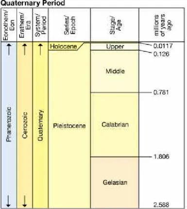
Period?
Subdivision of the geological time which covers the last 2.6 million years up to the present day. It is further subdivided into two epochs; the Pleistocene (up to about 11,700 years ago) and the Holocene (about 11,700 years ago to the present day). The Quaternary has been one of extraordinary changes in global environment as well as the period during which much of human evolution took place. https://www.qra.org.uk
Figure Box 4.2
The Quaternary Period: Series/Epochs and Stages/Ages, in millions of years. Source: 2012 International Stratigraphic Chart, published by the International Commission on Stratigraphy, http://www.stratigraphy.org/
climatic cycles characterised by alternating colder and warmer conditions, occurred. These cycles are named as Dansgaard–Oeschger (D–O) Stadials and Interstadials, corresponding to cold and warm phases, respectively, and having a periodicity of ca. 20,000 years, as illustrated in figure 4.14. Some of the D–O Stadials were related to episodes of massive iceberg discharges into the North Atlantic Ocean, named Heinrich events (HE) that occurred with a periodicity of ca. 7,000 years (Figure 4.14).
Since then, during late Pleistocene, the Northern Hemisphere was marked by a succession of major deglacial climatic events that preceded the Holocene period. These events were named as the Oldest Dryas (ca. 18,000-14,700 cal. years B.P.; the Bølling/Allerød warm period (ca. 14,600 to 12,900 cal. years B.P.) and the Younger Dryas cold event (ca. 12,900 to 11,700 cal. years B.P.) (Figure 4.14).
Figure 4.14.
Climate variability since the last glacial period: grey line marker is the atmospheric temperature record of the Greenland ice core GISP2 reconstructed from oxygen stable isotope data. Interstadial cycles correspond to the numbers on top of the grey line marker, Heinrich events are signalised on the bottom. YD – Younger Dryas, BO -Bølling/Allerød, OD – Oldest Dryas (adapted from Cacho et al., 2002).
The Holocene was also a time of abrupt, cyclic climatic changes in the North Atlantic. The early- to mid-Holocene was characterized in the Iberian Peninsula (including the Guadiana Valley) by wet conditions, in a warm climate known as the Holocene Thermal Maximum. From the mid-Holocene onwards, a shift in insolation and the installation of the present-day atmosphere circulation in the northern hemisphere occurred, with the progressive instauration of drier conditions. Along the Mediterranean Basin, a regional response to these global climatic oscillations forced the establishment of an arid, Mediterranean-like, climate. During the late Holocene, the NAO has influenced major climatic and environmental changes across Europe, such as the Medieval Warm Period and the Little Ice Age periods.
How did the sea level evolved during the Quaternary?
During the Quaternary, the main control on sea-level change was the exchange of mass between ice sheets and oceans, with cold periods inducing ice sheet growth and sea-level eustatic lowstands (phases of lower sea level regarding the present). In the course of the Last Glacial Maximum (LGM) the sea level was around 125 +/- 5 m lower than the present day. An initial slow, postglacial rise lasted from ca. 21,000
to 17,000 cal. B.P., followed by an increase in the rate of rise for the next 10,000 years, until the decay of most of the large ice sheets was completed by 7,000 cal. B.P.
In agreement with the worldwide sea-level datasets, sea-level reconstructions for the western European margin point to persistent sea-level rise throughout the early- to mid-Holocene, including different areas along the Iberian Margin and the Bay of Biscay (Figure 4.15).
Figure 4.15.
Examples of Sea-level curves for the Eastern North Atlantic during the late Pleistocene and Holocene periods (MSL – Mean Sea Level). The model curves correspond to data from: southern Spain estuaries, Tagus River valley, Guadiana estuary, Bay of Biscay and Algarve beaches.
The most recent data concerning the infilling of the Guadiana estuary further indicated that since ca. 7,500 cal. years B.P. the sea level has continued to oscillate with a slow rate of rise until present-day conditions.
Sediments
Linkage between the evolution of sediment deposition on the Guadiana Shelf and the infilling of the Guadiana estuary
Shelf depositional patterns throughout the late Pleistocene and Holocene have been influenced by the evolution of the Guadiana estuary and its infilling. A first phase of accelerated infilling and trapping of clays occurred between ca. 13,000 and 7,500-7,300 cal. years B.P., when the sea-level rise was fast. The second phase was driven by a much slower sea-level rise between ca. 7,500-7,300 and 5,700 cal. years B.P., when mostly sands began to accumulate in the estuary. When sea level stabilized in the region after ca. 5,500 cal. years B.P., the estuarine infilling continued with deposition of sand bodies and salt marshes on both the western (Portuguese) and eastern (Spanish) margins. Consequently, the estuary acted as a major sediment sink.
Learning more about how did the sediment components of the Guadiana Shelf deposits evolved through time: clues to understand past environmental changes
The deposits of the Guadiana continental shelf have been extensively studied during the past years using sediment cores, in particular the fine-grained sediments of the middle shelf composing the Guadiana mud belt. Calm hydrodynamic conditions, set beyond the influence of storms, tides and coastal currents, favoured a continued deposition and the creation of a complete sedimentological record through time,
without remobilisation of sediments and consequent hiatus/gaps in the depositional succession. Grain size trends are also detected, as the sediments become finer from the bottom (deeper, older sediments) towards the top (younger sediments, located closer to the sea floor surface). Sediments became particularly dominated by fine material after around 2,000 cal years B.P. (Figure 4.16).
Figure 4.16.
Depth (cm), size-types of sediment (gravel, sand, silt and clay) and depth levels selected for radiocarbon dating (ages are given in radiocarbon years B.P. and calibrated ages - cal. years B.P.) along a sediment core obtained from the Guadiana middle continental shelf (adapted from Rosa, 2014).
The distribution of the components of sandy sediments along time reveals the dominance of the
terrigenous/lithologic material and an increase in the diversity of the bioclasts (marine-derived) towards the top/more recent part of the depositional successions (Figure 4.17). Within the bioclasts, shallower forms (namely mollusc shells), that are associated with more energetic/coastal conditions, were more abundant in the lower/older part of the sequences, whereas towards the top/more recent deposits, foraminifera, which are much smaller and with preference for deeper and calmer marine habitats, became more abundant (Figure 4.17).
These main changes in the sediment grain size and in the composition of the sand-sized material along time are used as indicators, or proxies, of past environmental changes that occurred in the continental shelf and allow reconstructing the history of deposition driven by sea level and climate changes and the more recent human impacts.
At current deep locations of the middle shelf, shallow-marine environments were developed during the Late Pleistocene, inferred by the grain size heterogeneity and the dominance of fluvially-supplied particles (mostly the OT – other terrigenous/lithoclastic and mica particles). It would have been set in
close proximity to the Guadiana River mouth and the river discharges, when the sea level was several meters below its present day position and the river mouth was located further offshore, in present-day deeper areas of the shelf.
The fast sea-level rise decreased the river export-capacity due to the infilling of the Guadiana estuary, as part of the sediments transported by the river were being trapped inside the estuary by the rising waters in the transition of the Late Pleistocene and the Early Holocene periods.
When the sea-level rise decelerated, between the Early and the Mid Holocene, a prevailing influence of the Guadiana sediment inputs was persistently detected. The increase of clays and of benthic foraminifera within the sands shows the progressive establishment of these shelf areas in a deeper marine
environment as the sea continued to rise.
After the sea level was nearly stabilised in the region in the Mid Holocene, at ca. 6, 000 cal. yrs B.P., the disappearance of fluvial-supplied particles at more distal shelf locations points to a gradual decrease of the impact of the fluvial inputs, as the depositional environments evolved to become progressively better established at deeper depths, within a middle shelf setting.
In the Late Holocene, after ca. 2,500 cal. yrs. B.P. and until present-day, depositional patterns across the shelf were characterised by enhanced fine sedimentation and sedimentation rates, associated with further increased fluvial supplies. The first major human impacts in the Guadiana River Basin caused by the Roman and Islamic Rules of Iberia, coupled with the climatic shifts of the North Atlantic Oscillation (NAO), are believed to have been the main cause for the onset of the most recent chapter in the depositional history of the Guadiana continental shelf.
Figure 4.17.
Relative abundances (%) of sand components and proportion (%) of terrigenous versus biogenic content on the mud body deposits. Legend: OT – other terrigenous particles than quartz, AGG – aggregates, S/G –
schist/greywackes, SANDST – sandstones, CARBLIT – carbonate lithoclasts, BFORAMS – benthic foraminifera, PFORAMS – planktonic foraminifera, OB – other bioclasts (adapted from Rosa, 2014).
Benthic foraminiferal faunas
Learning more about the evolution of the Guadiana Shelf microfossil assemblages of benthic foraminifera: clues to understand past environmental changes
The study of the benthic foraminiferal microfossils is based on the identification of the most abundant species present in the sediments, and the variations of their distribution and diversity through time. Knowing their environmental constraints and habitat preference, as was explained previously in Sub-chapter 4.2.1, it becomes possible to use them as indicators, or proxies, of the environmental changes occurred in the continental shelf in the past. Hence they support the sedimentological information in the task of reconstructing the depositional history of the shelf.
The evolution of benthic foraminiferal communities in the Guadiana middle shelf
The interpretation of the fossil benthic foraminiferal assemblages that colonised the Guadiana middle shelf deposits through time, proved to be a valuable tool to reconstruct the past shelf depositional environments (Fig. 4.18).
Figure 4.18.
Faunistical density (number of foraminifera per gram of sediment), species richness (number of species), diversity indices Shannon-Wiener and Evenness, abundance (%) of main benthic foraminiferal species, main benthic foraminiferal species in a sediment core from the Guadiana middle shelf (adapted from Rosa, 2014).
Combining all the micropalaeontological data obtained for the Guadiana middle shelf, the foraminiferal species were gathered in different sets with the help of multivariate statistics to improve their
palaeoenvironmental interpretation. Each of these sets, Groups and Biofacies, has a specific
environmental significance: Groups refer to groups of species that show a similar evolution trend in their abundance along time; Biofacies refer to the specific species composition of the benthic assemblages for a given period (different combinations of Groups) along the depositional/geological record (Fig. 4.19).
In the Late Pleistocene, the benthic foraminiferal groups were dominated by coastal species that inhabit the surface of the bottom sediments and adapt better to strong currents. They are consistent with a shallow marine depositional environment that was set on the under direct fluvial influence, when the sea level was well below its present day position.
During the Latest Pleistocene and Early Holocene the increase of faunistical densities and a change in the dominant species, with species better adapted to quieter, deeper marine domains, becoming increasingly more abundant indicate the gradual increase of water depth as the sea level continued to rise fast during this period.
The evolution of the benthic foraminifera towards the Mid Holocene is consistent with the continuous deepening of the depositional shelf environments during the last phases of the Holocene sea-level rise that eventually lead to the establishment of water depths very identical to modern ones. Simultaneously, prevailing river nutrient influxes to the shelf assured continuous organic-rich conditions in the area, favourable to the development of the benthic communities.
Figure 4.19.
Abundance (%) of main benthic foraminiferal species in a sediment core from the Guadiana middle shelf. Colored arrows represent the main shifts in abundance observed for several species along time (adapted from Rosa, 2014).
The last ca. 2,500 years were marked by several abundance/diversity peaks of the benthic foraminiferal assemblages. The significant presence of species with preference for organic matter-enriched fine sediments were associated with particularly high inputs of nutrients derived from enhanced supplies of the Guadiana River onto the shelf. Moreover, the appearance of specific taxa that had been absent from the shelf environment until this time, was symptomatic of new ecological conditions being established in the area. These overall changes within the benthic foraminiferal population are consistent with the information obtained with the sedimentological study of the deposits, in the sense that the Roman and Islamic Rules of Iberia played a major role in the most recent evolution of the depositional environments on the shelf.
acknowledgements
This work was supported by the Portuguese Science Foundation (FCT) under the aims of projects CRIDA (Consequences of River Discharge Modifications on Coastal Zones and Continental Shelf
-PDCTM/P/MAR/15289/1999); IMCA (Impact of climatic and anthropic variations on the northern continental shelf, Gulf of Cadiz - POCTI/CLI/60192/2004) and CIRCO (Climate changes from isotopic records during the Holocene in South-western Iberia - PTDC/CLI/66393/2006). The authors would also like to acknowledge the FCT for grants SFRH/BPD/72869/2010 and SFRH/BD/46020/2008. Thank you also to Dr. Telmo Nunes (Centro de Microscopia Electrónica, Faculdade de Ciências da Universidade de Lisboa) for his assistance obtaining the scanning electron microscope images (SEM) included in the present work.
Consulted bibliography
Cacho, I., Grimalt, J. O. & Canals, M., 2002. Response of the Western Mediterranean Sea to rapid climatic variability during the last 50,000 years: a molecular biomarker approach. Journal of Marine Systems, 32-34: 253-272.
Criado-Aldeanueva, F., García-Lafuente, J., Navarro, G. & Ruiz, J., 2009. Seasonal and interannual variability of the surface circulation in the eastern Gulf of Cadiz (SW Iberia). Journal of Geophysical Research 114: C01011.
Delgado, J., Boski, T., Nieto, J. M., Pereira, L., Moura, D., Gomes, A., Sousa, C. & García-Tenorio, R., 2012. Sea-level rise and anthropogenic activities recorded in the late Pleistocene/Holocene sedimentary infill of the Guadiana estuary (SW Iberia). Quaternary Science Reviews, 33: 121-141.
Fernández-Salas, L.M., Durán, R., Mendes, I., Galparsoro, I., Lobo, F.J., Bárcenas, P., Rosa, F., Ribó, M., García-Gil, S., Ferrín, A., Carrara, G., Roque & C., Canals, M., 2015. Shelves of the Iberian Peninsula and the Balearic Islands (I): Morphology and sediment types. Boletín Geológico y Minero 126: 327-376. García-Lafuente, J., Delgado, J., Criado-Aldeanueva, F., Bruno, M., Del Río, J. & Miguel Vargas, J., 2006. Water
mass circulation on the continental shelf of the Gulf of Cádiz. Deep-Sea Research II 53: 1182 -1197. Gonzalez, R., Dias, J.A., Lobo, F. & Mendes, I., 2004. Sedimentological and paleoenvironmental
characterisation of transgressive sediments on the Guadiana Shelf (Northern Gulf of Cadiz, SW Iberia). Quaternary International 120: 133-144.
Lario, J., Spencer, C., Plater, A.J., Zazo, C., Goy, J.L. & Dabrio, C.J., 2002. Particle size characterisation of Holocene back-barrier sequences from North Atlantic coasts (SW Spain and SE England).
Geomorphology 42: 25- 42.
Leorri, E., Cearreta, A. & Milne, G., 2012. Field observations and modelling of Holocene sea-level changes in the Southern Bay of Biscay: implication for understanding current rates of relative sea-level change and vertical land motion along the Atlantic coast of SW Europe. Quaternary Science Reviews, 42: 59-73.
Lobo, F. J., Fernández-Salas, L. M., Hernández-Molina, F. J., González, R., Dias, J. M. A., Díaz del Río, V. & Somoza, L., 2005. Holocene highstand deposits in the Gulf of Cadiz, SW Iberian Peninsula: A high-resolution record of hierarchical environmental changes. Marine Geology, 219(2-3): 109-131. Lobo, F.J., Roy, P.L., Mendes, I. & Sahabi, M., 2014. The Gulf of Cádiz continental shelves, In: Chiocci, F.L.,
Chivas, A.R. (Eds.), Continental Shelves of the World: Their Evolution During the Last Glacio-Eustatic Cycle. Geological Society, London, Memoirs, pp. 109-130.
Lobo, F.J., Durán, R., Roque, C., Ribó, M., Carrara, G., Mendes, I., Ferrín, A., Fernández-Salas, L.M., García-Gil, S., Galparsoro, I., Rosa, F. & Bárcenas, P., 2015. Shelves around the Iberian Peninsula (II): Evolutionary sedimentary patterns. Boletín Geológico y Minero 126; 377-408.
Mendes, I., Rosa, F., Dias, J. A., Schönfeld, J., Ferreira, Ó. & Pinheiro, J., 2010. Inner shelf paleoenvironmental evolution as a function of land-ocean interactions in the vicinity of the Guadiana River, SW Iberia.
Quaternary International, 221: 58-67.
Mendes, I., Dias, J.A., Schönfeld, J. & Ferreira, Ó., 2012. Distribution of living benthic foraminifera on the northern Gulf of Cadiz continental shelf. Journal of Foraminiferal Research 42: 18-38.
Mendes, I., Dias, J.A., Schönfeld, J., Ferreira, Ó., Rosa, F., Gonzalez, R. & Lobo, F.J., 2012. Natural and human-induced Holocene paleoenvironmental changes on the Guadiana shelf (northern Gulf of Cadiz). The
Holocene 22: 1011-1024.
Mendes, I., Dias, J.A., Schönfeld, J., Ferreira, Ó., Rosa & F., Lobo, F.J., 2013. Living, dead and fossil benthic foraminifera on a river dominated shelf (northern Gulf of Cadiz) and their use for
paleoenvironmental reconstruction. Continental Shelf Research 68: 91-111.
Murray, J.W., 2006. Ecology and applications of benthic foraminifera. Cambridge University Press, Cambridge, 426p.
Rosa, F., 2014. Climatic variability and recent sedimentation in the Continental Shelf off the Guadiana River. PhD Thesis, University Algarve, Faro, Portugal, 288 p.
Rosa, F., Dias, J. A., Mendes, I. & Ferreira, Ó., 2011. Mid to late Holocene constraints for continental shelf mud deposition in association with river input: the Guadiana Mud Patch (SW Iberia). Geo-Marine Letters, 31: 109-121.
Teixeira, S.B., Gaspar, P. & Rosa, M., 2005. Holocene sea-level index points on the Quarteira Coast (Algarve, Portugal), In: Freitas, M.C., Drago, T. (Eds.), Coastal Hope, Lisbon, pp. 125-127.
Vis, G.-J., Kasse & C., Vanderbergh, J., 2008. Late Pleistocene and Holocene palaeogeography of the Lower Tagus Valley (Portugal): effects of relative sea level, valley morphology and sediment supply.