Maia Charlotte Williams
CONTRIBUTION TOWARDS UNDERSTANDING
ii
CONTRIBUTION TOWARDS UNDERSTANDING
THE CATEGORISATION OF LANDFORMS
Dissertation supervised by: Professor Doctor Marco Painho Professor Doctor Werner Kuhn Professor Doctor Rafael Berlanga Llavori
iii
ACKNOWLEDGEMENTS
I would like to offer a warm thank you my supervisors Dr Marco Painho and Dr Werner Kuhn for their invaluable guidance and support throughout the project. It was fantastic to learn from you, and to have your input and suggestions throughout the course and this dissertation. Thank you also to my co-supervisor Dr Rafael Berlanga Llavori for your supervision. My thanks also to Dr David Mark for your interest and input into the project, and to Dr Ana Cristina Costa for help with my numbers.
For help with the field work in the Serra da Lousã, thank you to: Ana Sota at Dueceira, Kerstin at the Loja de Candal, Sandra at Lousitânea, and the participants of Lousã and the Aldeias do Xisto. For help with field work in Odemira, thank you to: Paula, Lena, Vera and other TAIPA employees, and the students of the Higiene e Segurança no Trabalho course.
For sharing ideas and dreams in the beginning, thank you Joana Malta. And to Pedro Lisboa, thank you for being my film star and a most appreciated interview decoder. Thank you also to Paulo Bianchi Candeias for the interpretation of language beyond me. To Silvia Cotrim, thank you for translation work and Portuguese lessons.
My most sincere thanks to my inspiring friends from this course for keeping me motivated. A special thank you to Mohammed Abdullah Abu Diyan and Sanjana Islam for trusting me with their camera, and for much plotting and scheming over ‘Deshi tea.
A huge deep thank you to Kent Williams, for instilling in me a love of landscapes, of the dirt and rocks and forms of the earth, and for sharing with me the tools of the trade. Thank you also to the incredibly talented Miranda Peden for exploring Portugal with me, co-directing my movies, being my chief editor and understanding completely why this project was so challenging and exciting. You are wonderful parents. Thank you for your support.
iv
CONTRIBUTION TOWARDS UNDERSTANDING
THE CATEGORISATION OF LANDFORMS
ABSTRACT
Categorisation in the geographic domain, including landform categorisation, is more subject to influence by cultural, linguistic, environmental and individual factors, than other domains. The study presented in this dissertation investigates the influence of landscape variation on the landform categories used by non-experts.
Video-elicitation methods were used in interviews with inhabitants of two distinct landscape types, in Portugal. One study site was mountainous and topographically varied, while the other consisted of more homogenous, gently undulating terrain. Interview responses indicated that participants used more landform terms in descriptions of familiar landscapes. Specific place recognition was another stimulant for an increase in landform categorisation detail. Additionally, the participant group from the more homogeneous landscape had a smaller landform vocabulary, and primarily used variations on a core set of landform terms to describe topographic eminences. The other group had a much larger and more varied vocabulary.
A Digital Elevation Model (DEM)-based landform classification compared well with participant landform categories at a macro scale. A qualitative analysis of participant responses suggested that their drivers for categorisation are the salient features of the landscape (such as elevation and land cover), as well as utilitarian motivations (such as land-use, context and familiarity).
v
KEY
WORDS
Cognitive geography Ethnophysiography
Geographic Information Systems (GIS) Landform categorisation
vi
TABLE
OF
CONTENTS
ACKNOWLEDGEMENTS ... iii
ABSTRACT ... iv
KEY WORDS ... v
TABLE OF CONTENTS ... vi
INDEX OF TABLES ... ix
INDEX OF FIGURES ... x
1 INTRODUCTION ... 1
1.1 Context ... 1
1.2 Geographic concepts ... 1
1.3 Research questions ... 2
1.4 Conceptual framework ... 3
1.5 Research design ... 4
1.6 Study scope ... 4
2 LITERATURE REVIEW ... 5
2.1 Overview ... 5
2.2 Categorisation ... 5
2.2.1 In general ... 5
2.2.2 Categorisation of landscapes into landforms ... 6
2.3 Ethnophysiography ... 9
2.4 Landscape ... 10
2.4.1 The concept ... 10
2.4.2 Landscape in Portugal ... 11
2.5 Mountains ... 11
2.6 Category norms research ... 12
2.7 Linguistics and GIScience... 14
2.8 Place and place names ... 15
3 STUDY SITES ... 16
3.1 Serra da Lousã ... 16
3.2 Odemira ... 17
4 METHODOLOGY ... 19
vii
4.1.1 Justification for using video ... 19
4.1.2 Preparation ... 21
4.1.3 Interview structure ... 22
4.1.4 Interview interpretation and data extraction ... 23
4.2 DEM-derived landform classification ... 24
4.2.1 Choice of method ... 24
4.2.2 Classification methodology ... 25
5 RESULTS ... 27
5.1 Landform categorisation by participants ... 27
5.1.1 Participant interview information ... 27
5.1.2 Notes on the collation of results ... 27
5.1.3 Results from descriptions of Lousã video ... 28
5.1.4 Results from descriptions of the Odemira video ... 29
5.1.5 Combined results ... 31
5.1.6 Water and vegetation in the results ... 36
5.2 DEM-derived landform classification ... 38
6 DISCUSSION ... 41
6.1 Comparison of participant landform categorisations ... 41
6.1.1 Differences in categorisations due to landscape familiarity and recognition of place... 41
6.1.2 Commonalities in landform vocabulary ... 45
6.1.3 Differences in landform vocabulary ... 46
6.2 Comparison of DEM landform classification and participant landform categorisation ... 48
6.3 Observations regarding categorisation drivers ... 50
6.3.1 Evidence of multiple drivers ... 50
6.3.2 Land cover and land-use ... 50
6.3.3 Context ... 51
6.3.4 Familiarity and mental maps ... 52
6.4 The importance of water ... 53
6.5 Observations regarding place names ... 54
7 LIMITATIONS ... 54
viii
9 CONCLUSIONS ... 58
10 REFERENCES ... 61
APPENDIX 1: VOCABULARY LISTS ... 66
APPENDIX 2: SUMMARIES OF TERM USE PER PARTICIPANT ... 70
APPENDIX 3: ASTER DIGITAL ELEVATION MODEL MAPS ... 74
APPENDIX 4: MORGAN AND LESH LANDFORM CLASSIFICATION ... 75
APPENDIX 5: AGGREGATED LANDFORM CLASSES ... 77
APPENDIX 6: LANDFORM CLASSIFICATION AT VIDEO VIEWPOINTS IN 2 ½ D ... 78
APPENDIX 7: LANDFORM CLASSES AND PARTICIPANT TERMS ... 83
ix
INDEX
OF
TABLES
Table 1. Class thresholds of landform classification sub-sections ... 26 Table 2. Recognition and number of landform terms for Lousã participants - Lousã video ... 29 Table 3. Recognition and number of landform terms used, Odemira participants - Odemira video... 31 Table 4. Aggregation of the landform terms into generalised categories, counts and percentage frequencies of occurrence ... 33 Table 5. Term distribution within each participant group ordered from most to least common ... 34 Table 6. Term distribution between participant groups, ordered from most to least common for Lousã participants (and least to most common for Odemira
participants) ... 35 Table 7. Total term counts and frequencies of occurrence per participant group ... 36 Table 8. Morgan and Lesh landform classes with corresponding participant terms, Lousã video ... 40 Table 9. Morgan and Lesh landform classes with corresponding participant terms, Odemira video... 40
x
INDEX
OF
FIGURES
Figure 1. Conceptual framework ... 3
Figure 2. Study site location map ... 18
Figure 3. Video views 1 - 5, Lousã ... 29
Figure 4. Video views 1 - 5, Odemira ... 30
Figure 5. Landform term distribution within participant – video groups as percentage frequency of occurrence ... 37
Figure 6. Landform term use distribution between participant - video groups as percentage frequency of occurrence ... 37
Figure 7. Morgan and Lesh landform classification map with video view sites and participant residence locations, Lousã ... 38
Figure 8. Morgan and Lesh landform classification map with video view sites and participant residence locations, Odemira ... 39
Figure A 1. Lousã site DEM ... 74
Figure A 2. Odemira site DEM ... 74
Figure A 3. Slope sub-model ... 75
Figure A 4. Relief sub-model ... 75
Figure A 5. Profile sub-model ... 76
Figure A 6. Final classification ... 76
Figure A 7. View 1 Morgan and Lesh landforms, Lousã ... 78
Figure A 8. View 2 Morgan and Lesh landforms, Lousã ... 78
Figure A 9. View 3 Morgan and Lesh landforms, Lousã ... 79
Figure A 10. View 4 Morgan and Lesh landforms, Lousã ... 79
Figure A 11. View 5 Morgan and Lesh landforms, Lousã ... 80
Figure A 12. View 1 Morgan and Lesh landforms, Odemira ... 80
Figure A 13. View 2 Morgan and Lesh landforms, Odemira ... 81
Figure A 14. View 3 Morgan and Lesh landforms, Odemira ... 81
Figure A 15. View 4 Morgan and Lesh landforms, Odemira ... 82
1
1
INTRODUCTION
1.1 Context
With the ever broadening use of Geographic Information Systems (GIS) and the greater access to GIS-based tools by both geographic information experts and other non-expert users, there is the need to consider the impacts of this expansion. Advances in geographic domain awareness have been made with the help of web-based applications such as GoogleMaps, and correspondingly the use of GIS-web-based data analysis and presentation has developed for use within and between domains, cultures, languages and locations. The communication and sharing of spatial information has grown in response to recognition of the importance of knowing what is (happening) where, and there is great demand for Geographic Information Science (GIScience) developments (BESR, 2007). As GIS is being adapted and modified to fit into all conceivable applications and domains, a critical look at how effectively this is being done is required. While the technological possibilities race ahead it is important to stand back and question: what lies beneath, what is the meaning of all this spatial information people so desire? The data we use to make our decisions with, called the objective scientific truth; does it actually make sense whenever and wherever we want it to? (Goodchild, 2010; Mark, 2000)
1.2 Geographic concepts
There is the need to examine the conceptualisations of the fundamental objects or phenomena which provide the basis for geographic information analysis and representation within a GIS. A conceptualisation is a simplification, an abstraction, of the real world which we use to refer to what is there (Gruber, 1993). The geographic objects in question in this dissertation are the concepts such as mountain, hill and valley which are commonly used to describe landscapes. These categories are called landforms and describe the features of the earth’s surface. There is the need to understand both how the conceptualisations of different geographic features relate to each other, but also the variations of these conceptualisations according to the cultural, linguistic, environmental and individual influences which form them.
2
ontologies (Levinson, 2008). In GIScience applications ontologies are commonly defined using Gruber’s (1993) explanation of them being an ‘explicit specification of a conceptualisation’. They are used to describe, formally, the relationships between concepts understood to belong to a particular domain. Before this process of formalisation can be performed, or rather, in order for the resultant ontology to be useful, the variations in the conceptual space each concept occupies must be understood. The limits within which a concept is thought to exist or be understood must be defined based on empirical studies (Smith and Mark, 2001).
The critical examination of the assumptions which form the foundations of GIS is central to research conducted within the field of ethnophysiography. Work in this area aims to explore the variations in the terms (and meanings of the terms) people use to refer to parts of natural landscapes (Mark and Turk, 2003a). By observing the categories people form and the drivers for their formation, the relationships between the concepts can be better understood and the geographical domain ontology enriched. This is an important step towards achieving the interoperability of GISs across cultural, linguistic and domain boundaries (Kuhn, 2011).
1.3 Research questions
The inter-cultural and inter-linguistic variations in geographic domain conceptualisations have been explored from both GIScience and linguistic perspectives (Burenhult and Levinson, 2008; Levinson, 1996; Mark and Turk, 2003b). Another important driver to consider is that of the variations in the physical landscape itself. The question of if, and how, the type of landscape people live in effects the categories of landforms they conceive, is the motivation for this dissertation.
In order to investigate, the following research questions are posed, and will be explored:
1. Do people identify categorisations with greater degrees of detail in landscapes they are very familiar with, compared to lesser known landscapes?
3
3. Is there any evidence suggesting that landscape categories are developed according to utilitarian factors more than salient features?
1.4 Conceptual framework
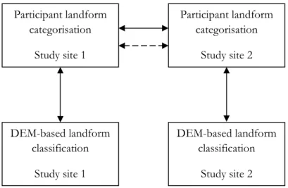
A simple conceptual model has been designed to address the research questions of this dissertation (see Figure 1). There are two major components to the model: (1) landform categorisations given by participants from two study sites and (2) automated landform classifications derived from a Digital Elevation Model (DEM). This provides landform category data for the same two regions of Portugal, from an individual, non-expert human perspective and a predefined, automated elevation-based method. The information extracted from participant responses is compared between the two study sites, as well as against the automated classification. The first of the research questions will be addressed with a quantitative explanatory analysis. The other two aspects of the study will be presented descriptively. Additional exploratory analysis of the participant responses and the extracted data will be discussed where relevant.
Figure 1. Conceptual framework : Quantitative comparison Participant landform
categorisation
Study site 1
Participant landform categorisation
Study site 2
DEM-based landform classification
Study site 1
DEM-based landform classification
Study site 2
4 1.5 Research design
The research design for this dissertation is based on the above-mentioned conceptual framework. The most important aspect of the research design was site selection: in order to meet the study objectives two topographically distinct landscapes were required as study sites. The details of the chosen study sites are presented in Chapter 3. Following site selection, data was collected using a combination of interviews and Geographic Information System (GIS) analyses. An extensive literature review provides justification for the methods implemented and places the research in context. The interviews were conducted with residents of the study sites, using video-elicitation techniques. They were recorded to allow for landform information extraction at a later date. The DEM landform classification was performed using Advanced Spaceborne Thermal Emission and Reflection Radiometer (ASTER) 30m resolution data with a well known deterministic method. The data extracted from interviews is presented as an aggregated dataset to minimise the effects of data incompleteness and individual variation.
1.6 Study scope
The scope of the project is limited to a small section of the greater field of cognitive geography, and more specifically landform category development. The project has been designed to consider primarily the effects of landscape on the categorisation process, separately from cultural and linguist influences, as has been the focus of previous research in the area. Although language and cultural practices are not separate from landscapes and are not constant across a country, for the purposes of this study the influence of these variations and inter-relationships have been assumed to be minimal.
5
2
LITERATURE
REVIEW
2.1 Overview
In this Chapter the key findings of relevant areas of research are explored. Research on categorisation, and specifically the categorisation of landforms, is presented first as it is the major focus of this dissertation. Following on, work on landscapes and the human-environment relationships which contribute to the understanding of landscapes, is presented. This is important because the effect of these relationships on the categorisation of landforms is in question. The following body of work is about mountains specifically, as they are such prominent features in landscapes and cultures, yet so conceptually elusive.
The next area of work is the category norms research which has identified some common landform terms at a country scale. This is followed by a discussion of the value of multidisciplinary GIScience and linguistic approaches to research. The final body of work is about the concept of place, and the naming of places across a landscape.
2.2 Categorisation
2.2.1 In general
The general process of categorisation involves grouping similar objects or events into a category and treating them as the same. This process is one of the most basic tasks performed by people and animals. Categorisation has become a research area in many fields – psychology, anthropology and philosophy, largely – and researchers have aimed to answer questions about the formation of category boundaries, similarity of category members and level of abstraction required to perform the categorisation process (Mervis and Rosch, 1981).
6
Categorisation on the other hand is an ordering mechanism which is based simply on a perceived similarity of category members within a given context. It is a much more flexible system and the borders between categories are often changeable and fuzzy (Jacob, 2004). The study presented in this dissertation is concerned with the processes of cognitive categorisation.
In the Principles of Categorization of 1978, Rosch proposes two major principles of categorisation which account for both the vertical and horizontal growth of taxonomic categorisation (tree) structures formed around basic-level categories. They are simply: (1) ‘the task of category systems is to provide maximum information with the least cognitive effort’ and (2) ‘the perceived world comes as structured information rather than as arbitrary or unpredictable attributes’ (Rosch, 1978). The basic level categories at the centre of these structures are those which we learn at a very young age, and which are formed as a balance between informativeness and cognitive cost (Smith and Mark, 2003). The balance of informativeness versus cognitive cost varies as one moves up or down from more to less detailed levels of the categorisation structure.
Another method of organising the possible different levels of categorisation structures is by the primary and secondary theories of anthropologist Robin Horton. Smith and Mark (2001) describe Horton’s primary theory as consisting of the basic theoretical beliefs which ‘relate to mesoscopic phenomena in the realm that is immediately accessible to perception and action’. His secondary theories, on the other hand, consist of beliefs which ‘are characteristic of different economic and social settings.’ They suggest that at the level of primary theory, there are likely to be universally consistent categories, while differences due to cultural, linguistic and individual influences are evident at the secondary level categories.
2.2.2 Categorisation of landscapes into landforms
7
landforms. Although it is not always the case, for the purposes of this dissertation it is assumed that categorisation of landscapes refers to the categorisation of the form of the landscape, into distinct landform types.
The process of categorising a landscape into meaningful categories, which can be used to understand and communicate knowledge about that landscape, is a complex one. In comparison to the categorisation of other domains into entities (or things or objects), landscape categorisation is highly subject to the influences of cultural, linguistic, environmental and purely individual factors. This is because unlike many other domains (for example, table top objects or plants), a landscape is essentially a continuous surface. The geomorphology of the land varies and there are physically similar types of landscapes reoccurring around the world due to similar climatic and geological processes, however there is little inherent organisation of this surface into obvious categories or kinds. The landscape does not impose an order within an individual’s conceptualisation and hence there is room for interesting variations due to factors beyond the shape of the land (Levinson, 2008; Mark et al., 2010).
When a landscape is categorised, the resultant landform categories (concepts) take a much more abstract form than that of plant or animal species categories, for example. While the categorisation of natural kinds or artefacts is driven by the presence of easily perceived bona fide boundaries, the division of a landscape is more similar to the conceptual division of a human body, as there is usually no clear visual line or parameter which can separate one section from another (Levinson, 2008; Smith and Mark, 2003).
It was initially proposed that the categorisation of both bodies and landscapes followed the expected whole-part theory of mereology (Mark, Smith et al., 1999). However later work has found that in some languages different types of relationships exist between landforms and bodies at different levels of categorisation (Enfield et al., 2006; Levinson, 2008). These studies are important for the understanding of human cognition and categorisation processes in general, simply because they do not conform consistently to the categorisation structures of other domains.
8
investigate the cross-cultural and cross-linguistic variations in landform categorisations, exploring the existence, if any, of universal categories, as well as determining the drivers and motivations for the formation of landscape categories. This work is not only important for the development of informed and inclusive geographic domain ontologies, and GIS applications, but also for the progression in understanding of cognitive categorisation processes in general (Smith and Mark, 1998).
The potential drivers for the formation of landscape categories have been summarised by Burenhult and Levinson (2008) as being (1) ‘perceptual or cognitive salience’, (2) ‘affordances…or…constraints [the categories] impose on human activities’ and (3) the presence of ‘conceptual templates and cultural beliefs’. The first refers to the formation of landform categories due to physically observable (or perceivable) features of the landscape, such as specific shapes in the relief, or changes in land cover type. The second driver leads to landforms grouped according to utilitarian motivations; that is, what the members of that category can offer to a person. The third driver refers to the presence of categories formed according to cultural beliefs related to the landscape, such as myths and legends that are connected with specific parts of the landscape.
9
The third driver is a reflection of the often strong link between cultures and landscapes. This link is particularly evident in the culture of Indigenous Australians and Mark and Turk (2003b) state that for many groups ‘spirituality and topography are inseparable’. This is reinforced by Anschuetz et al.’s (2001) claim that the term landscape can be thought of as encompassing different elements along the ‘culture-nature continuum’. Somewhere along this continuum lies the connection between the physical landscape and the culture of the people who live there, and this connection exerts its influence on the conceptualisation of landform categories.
It is unlikely, however, that any one of these drivers acts independently. Burenhult and Levinson (2008) suggest that the interesting areas of investigation lie in determining the interactions between the three mechanisms, rather than trying to isolate their contribution.
An important finding from the cross-linguistic comparison of landform vocabularies of people living in similar environments, was that although different groups had similar types of terms, the delineation of the categories varied. Burenhult and Levinson (2008) suggest that this is evidence of drivers of categorisation other than salient environmental features. They have not, however, discussed the variations of lexica within cultures across different landscapes.
Another approach to understanding the drivers for the categorisation of continuous environments into ‘object-like spatial regions’ has been proposed by Bian (2007). She is more concerned with the drivers for delineation and suggests that five factors are important: ‘spatial scale, boundary, attributes, process, and mobility.’ She explains regions as being defined by what is in them (properties) and their behaviour, and they can be mobile as they follow changes in attributes and processes. The delineation of landforms is likely to be governed by a number of these factors.
2.3 Ethnophysiography
10
because of the importance of understanding landform conceptualisation as a process with different drivers, compared to that of natural kind categorisation. These specialized fields can be grouped together under the area of landscape ethnoecology, each giving contributions to the understanding of ‘ecotopes’ – the term used to denote the categories of landscape ethnoecology – which incorporate biological, geological and ecological factors into the delineation of ‘kinds of land’ (Hunn and Meilleur, 2010). The methods of investigation of the conceptualisations of each field are comparable however, as they all seek to learn from the variations across cultures, languages, landscapes and individuals (Mark and Turk, 2003b).
2.4 Landscape
2.4.1 The concept
The word ‘landscape’ means different things in different contexts and people are required to be explicit about which landscape they refer to, for example: natural landscape, cultural landscape, urban landscape or spiritual landscape. This indicates the complexity of the concept. The term arose out of physical geography and it was Russian geographer Lev Semenovich Berg who first attempted to form a standard definition in the early 20th century. He opted for a broad definition which saw
geographical landscapes as the units of the study of geography, ‘repetitive groupings not only of forms of relief, but also of other objects and phenomena at the earth’s surface.’ (Shaw and Oldfield, 2007).
The recognition of landscapes going beyond the physical, was first introduced to geography as Geosophy by Wright (1947), as he introduced the idea of perceptions of landscape. He explored the ‘influence of imagination upon the creation of geographical knowledge’ and spoke of the individually variable and subjective views of landscapes (Keighren, 2005). These ideas retain their importance, and current definitions of landscape are inclusive of the relationships between people and their land, the meaning of place, and the cultural and spiritual influences which affect individual perceptions of the earth’s surface (Aikenhead and Ogawa, 2007).
11
a feedback loop that takes in both the potential of the land and human ways of making a living, including human technologies, cosmologies, and knowledge systems’ (Johnson and Hunn, 2010).
2.4.2 Landscape in Portugal
The study of landscapes in Europe (including Portugal) has a focus on understanding the perceptions of land-users and stakeholders in the face of land-use change. Research is being conducted from both sociological and land-use management perspectives, however all with an understanding of the dynamic and subjective nature of landscape (as described in the previous section) (Pedroli et al., 2006). Pedroli et al. state that landscape studies in Europe are all similar in that their methods include considerable stakeholder consultation and focus on people’s ‘perceptions and images’ rather than solely objective approaches.
This is evident in Surová and Pinto-Correia’s (2008) study of landscape perceptions and preferences amongst the different stakeholders of the Montado (cork oak) region in the Alentejo, Portugal. They found that in a time of rapid land-use change in this region there was considerable diversity in the perceptions of different user groups - hunters, mushroom pickers, beekeepers, landowners, Portuguese walkers and foreign walkers - depending on their interaction with the landscape. For example, landowners preferred the open landscapes with little shrub cover, as this would provide better access for farm machinery, whereas walkers preferred the more vegetated parts of the landscape. An awareness of these differences in perception is important for achieving sustainable land-use management practices within such multifunctional landscapes. Although the purpose of that study was different to that of this dissertation, their findings are relevant in that they highlight the variability of perceptions of landscapes due to utilitarian motivations.
2.5 Mountains
12
effects the culture, language and lifestyles of mountain people. The UNEP World Conservation Monitoring Centre (2002) dedicates much work to understanding mountain environments and their people. They state that ‘people would know a mountain when they see one’, yet agreeing upon definitions of what constitutes a mountain is incredibly difficult. The lack of globally understood definitions hinders integrated research on mountain environment sustainability.
Debarbieux (2004) presents a history on the many approaches taken in attempting to define what mountains are. Again the conclusions are that knowing elevation and slope are not enough and that factors like land cover are equally important in understanding what a mountain is.
The enigma of the mountain is explored from the ontological perspective by Smith and Mark (2003). They investigate just how difficult it is to extract the concept of a mountain, in contrast to the ease with which people refer to them and recognise them.
2.6 Category norms research
13
previously, this result was later challenged by the findings of ethnophysiography and linguistic studies.
An interesting aspect of the results was that there were significant differences in responses to the five sections, which means that non-expert common sense understandings of the ontological terms (object, feature, concept etc.) exist. These understandings do not necessarily match that of experts, however their existence is an important consideration for the development of useful geographic domain ontologies for widespread use amongst GIS-based applications.
A similar category norms experiment was conducted in Portugal by Pires (2005) and the results generally corresponded to the American responses. They concluded that, as with previous cross cultural comparisons, no significant differences could be claimed. Methodological differences meant that the total occurrence of responses were not comparable, but responses to ‘something geographical’ were very similar, with both surveys finding that river, mountain and ocean were listed in the top 5 most common responses.
Pires’ (2004) survey also included a section on natural earth formation where, again, respondents were asked to list five examples. The same question was posed in Battig and Montague’s survey in America. A comparison of the results showed both groups listing mountain, river, valley and rock in the top five most common responses. More interesting are the responses in the top 10 which are not common to both countries: canyon, cliff and cave for the Americans; and water, sea and plain for the Portuguese. It is likely that these categories reflect the presence of these features in each country. Similarly, five out of the top 10 Portuguese responses were water bodies (water, river, lake, ocean and sea) reflecting the fact that ‘Portugal is a wealthy country in terms of water bodies, which are a constant presence in…everyday life and history’ (Pires, 2004).
14 2.7 Linguistics and GIScience
The study of geographic concepts, categorisations and terms is interesting to linguists as well as GIScientists and, in fact, forms the link between the two disciplines. It is important for these two disciplines to be cognisant of each other, not only for the contribution of knowledge to common areas of interest, but for the definition of the vocabularies of space which each group employs. Weibel (2009) discusses the connections in a position paper presented at the 2009 workshop on Language, Space and Geography. There are two main components to the relationship: the role language plays in the distinction between space and place; and the investigation of the conceptual categories people use to describe both space and place. When referring to the latter, he states that there is ‘tremendous potential for future collaboration between linguistics and GIScience in this area’ (Weibel, 2009). In looking to the future collaboration between the disciplines Weibel suggests that an interesting research problem is that of making comparisons between linguistic variation and changes in physical (or otherwise) geography (for example, topography). This dissertation will make a contribution towards investigating this research problem, through the comparison of differences in geographic lexicon between study locations.
There is evidence of complimentary research agendas working well together, in the work of Mark and Turk (2003b) and Burenhult and Levinson (2008) at the Max Planck Institute of Psycholinguistics. Both groups converged upon the finding that ‘there are many degrees of freedom between, on the one hand, the continuous geological surface, and on the other, culturally recognized landform features and principles of toponymy’ (Levinson, 2008). There is a common understanding of the importance of considering the non-universality of geographic categorisations and lexicons in the context of global GIS use, and the linguists’ focus on determining the mechanisms driving these differences is an important contribution.
15
suggests this application of ontology-based reasoning is particularly relevant to the study of landscape in language, given the propensity for concept and lexicon variability within and between cultures.
Although ontology development is beyond the scope of this dissertation, the results could form the basis for regionally specific landform ontologies. Reasoning with such ontologies could be a method by which to address the research problem Weibel (2009) mentions – that of the correlation between linguistic and geographic variability (Kuhn, 2011).
2.8 Place and place names
Toponymy is the study of place names, the proper nouns people use to refer to specific locations. The study of place names and what constitutes ‘a place’ is a highly complex and multi-faceted area of research. In the context of ethnophysiography it is the relationships between landscape terms (names of categories) and place names which is of particular interest (Burenhult and Levinson, 2008; Mark and Turk, 2003a). The findings of studies of nine different language groups did not yield consistent patterns between the delineation and identification of landform categories, and the assignment of individual names, nor the structure of the names where given. In the Jahai language of Malaysia, place names are consistently linked to hydrological features in the landscape, and apply to catchment areas (as opposed to the watercourses themselves). This is particularly interesting because there is no general term for ‘catchment’ in their language (Burenhult, 2008). This lack of overlap of landscape terms and place names is quite different compared to other languages (including English) where there is a combination of monomorphemic (single part) place names which are independent of landform type and binomial (two part) names which include the landform type being referred to, for example Lisbon and Tagus River, respectively (Levinson, 2008). The relationships between place names and landform terms will be noted during the course of this dissertation.
16
cognition of geographic space. The potential influence of participants’ connections with places, on the categorisation of landforms (or communication of that categorisation) will be considered in this dissertation.
3
STUDY
SITES
3.1 Serra da Lousã
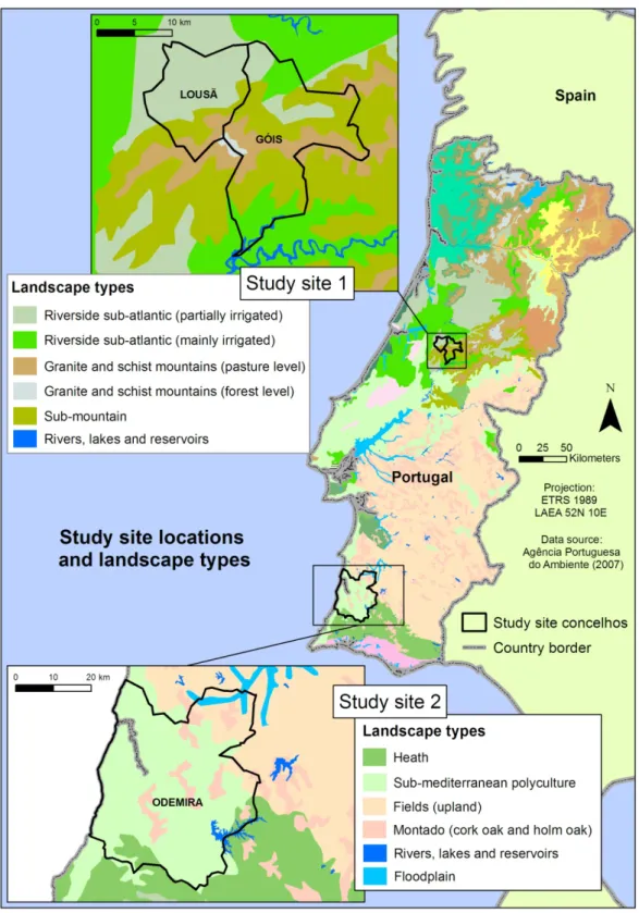
The first study site is situated in the Pinhal Interior Norte region of Portugal and includes the town of Lousã as well as several villages in the Serra da Lousã mountain range. These villages are situated in both the Lousã and Góis concelhos (municipalities). The area, covered by the two concelhos is 402 km2, shown in Figure 2.
This location was chosen due to the mountainous nature of the landscape and the useful network of rural development organisations (Dueceira, Lousitânea and Agência para o Desenvolvimento Turístico das Aldeias do Xisto) who could help find interview participants. The Serra da Lousã is a mountain range which rises steeply to the south east of Lousã town and has an elevation range of 200 to 1204 m (Câmara Municipal da Lousã, 2008). The mountains are largely covered in both natural (various oak species and chestnuts) and plantation (pine and eucalyptus) forests, with great variability due to the abrupt changes in elevation and climatic conditions throughout the area. There are also significant areas of open heather which are particularly important for the production of the honey for which the area is known (Lousitânea, 2010). The area receives a total annual precipitation of 1200 to 1600 mm/year and has an average daily temperature of 7.5 – 15 °C (Agência Portuguesa do Ambiente, 2007).
The underlying geology consists of a schist and greywacke complex, cut through by multiple quartz veins (Câmara Municipal da Lousã, 2008). It is from this rock that mountain inhabitants have long fashioned their homes, creating the unique schist villages.
17
Desenvolvimento Turístico das Aldeias do Xisto, 2008; Carvalho, 2004). The schist villages of the Góis concelho (Comareira, Aigra Nova, Aigra Velha and Pena) are, interestingly, more populated and inhabitants still keep gardens and animals. They are also a part of the schist village network which promotes tourism in the area.
3.2 Odemira
The second study site covers a portion of the Odemira concelho which lies in the Alentejo Litoral region, and is the biggest concelho in Portugal. Participants from this study area live in a number of different towns, namely: Odemira, São Luís, Boavista dos Pinheiros, Relíquias, Cabo Sadão, Zambujeira do Mar, São Teotónio, Azenha do Mar and Moitinhas Sabóia. The Odemira concelho covers 1697 km2.
The location was chosen due to the gently undulating landscape, and the different climate and land cover compared to the first study site. As with the first study site there is an active rural development organisation in the area (TAIPA – Organização Cooperativa para o Desenvolvimento Integrado do Concelho de Odemira), which was helpful in finding interview participants. The area consists largely of lowlands and small hills with a number of higher elevation ranges (such as the Serra de Cercal, 341 m) and one major river course (Rio Mira). The area also includes the mouth of the Rio Mira and a large stretch of coastline from Vila Nova de Milfontes to Azenha do Mar.
Like Lousã the underlying geology consists of schist and greywahcke, however in this region the substrate is folded into repeating elevations. There are also areas of sandstone and dune formations along the coast. The majority of the Odemira concelho
falls into the Colinas de Odemira (Hills of Odemira) landscape unit, excluding the Serra de Cercal. The soils in the area are at high risk of erosion (d'Abreu et al., 2004; Direcção Regional do Ambiente do Alentejo, 1998).
18
19
4
METHODOLOGY
4.1 Interviews
There are two major components to the methodology implemented for this study: the collection and interpretation of landscape descriptions by study site residents (study participants), and the calculation of a landform classification using a DEM, in ArcGIS.
The first component involved interviewing participants from both study sites, using video-elicitation techniques. The purpose of these interviews was to gather data about the landform terms and place names residents use to describe both their local landscape, and the less familiar landscape of the other study site. The methods used to prepare for and conduct the interviews were based on techniques implemented by a number of different authors, and modified to suit this current study.
4.1.1 Justification for using video
Interview methods involving photographs as prompts, have been used by ethnophysiographers and linguists in their work on understanding the language used to describe landscapes, and are well documented in Turk et al. (in press) and Bohnemeyer et al. (2004). The method was also used by Surová and Pinto-Correia (2008) in their study of landscape perceptions and preferences.
20
of different landscape patterns on …photographs, and their association with … activities, was relatively easy for respondents’. This is an important observation, and particularly relevant to the current study due to the mention of ‘activity’, because the utilisation of the landscape is a possible driver for categorisation.
Not only are visual cues a useful means of showing participants the locations they are asked to describe, but additionally it has been found that using photographs during interviews has an effect on the type of information people give. Photographs evoke people’s feelings and memory, which helps them to engage in the interview topic and speak with more depth (Harper, 2002).
Considering the language, time and location constraints of this study, the use of visual cues during interviews was deemed an appropriate method. Rather than using photographs as the above mentioned authors have done, video was considered a more useful medium. It allows for a sense of movement through the landscape, and a continuous view of a wider landscape scene (compared to, even, a panoramic photograph). This has the benefit of giving the viewer a greater sense of perspective, scale and context. It takes into consideration the understanding of Smith and Mark (1998), who state that ‘[o]bjects of geographic categorization are too large to be taken in within a single act of perception…and much…contextual knowledge will be required for categorization purposes’. Video allows for the relative positioning of landforms and the variations of land cover upon them to be seen, thus providing the viewer with more of the context they require to form their categorisations.
21
4.1.2 Preparation
The preparation stage of the interview methodology corresponds to Turk et al.’s (in press) Stage 1: ‘Dictionary work and photo collection – scoping the domain and preparing ‘instruments’’. A vocabulary list of landform, landscape and vegetation terms in Portuguese and English were assembled to familiarise the author with expected terms and aid in interview interpretation. The final list of terms and their definitions (sourced from the online dictionary/encyclopaedia www.infopedia.pt) are given in Table A 1, Appendix 1.
Two preliminary field trips were conducted (one to each study site) to take video footage and photographs of the landscape, and form contacts with the local organisations and individuals mentioned in Chapter 3. A range of film sites were selected to provide a set of images which give a good representation of the common landscape features of the area. Locations with an uninterrupted wide view across the landscape were chosen, and short (~30 second) pan shots were taken. Care was taken to maintain a similar distance from the major landforms in order to retain a consistent scale of view. Ten sites were filmed and photographed in each study area, with five subsequently used for the final film montage. The photographs and video were captured with a Panasonic Lumix DMC-LX3 wide-angle digital camera with 10 mega pixel resolution. The wide-angle was important for capturing the horizontal extent of the landscape. The coordinates of the film sites and direction of view were recorded using a GPS and a compass.
The videos and photographs of the five selected sites (for each study area) were combined into a 4 minute movie montage. The movie was organized such that the video image of each view was followed by a still photograph of the same scene. This was done in order to give the participants a chance to see how the parts of the landscape within the moving pan shot fitted together, before using the static image to describe the scene without being hurried by the movement. Windows Movie Maker software was used to create this movie montage.
22
occupation or sex were placed due to the limited capacity of the author to find suitable participants within the timeframe of this study. See Chapter 8 for suggestions of modifications to participant selection criteria for future studies.
4.1.3 Interview structure
The approach used for this study differs slightly from Turk et al.’s methods due to differences in objectives. For example, Turk et al. (in press) follow the steps: ‘2. Field interviews – identifying the set of landscape terms and distinctions’ and ‘3. Photo interpretation sessions – clarifying existing terms and collecting new ones’. Their interview methods involve direct questioning about, and comparisons of, specific landforms to form an understanding of the definitions of landscape terms according to the interviewee. The intention of the author of this dissertation however, was not to elicit definitions of terms and details of differences, but rather to compare the terms (and range of terms) used by interviewees from different locations, thus the interview process could be simplified.
The interviews consisted of two parts. Firstly, the purpose and format of the interview was outlined and the interviewees watched an introduction video which helped explain what was required of them. Secondly, two requests were made of the interviewees: they were asked to watch the two videos and name the landforms they could identify; and give the specific names (place names) of any places they recognised. They were then free to describe the landforms of their choosing with no prompting or questioning unless they were hesitant about what was expected of them. Additionally, interviewees were asked if they recognised the views in the video. The intention was to capture participants’ unbiased, natural ways of talking about landscapes, rather than asking them to carefully separate the landforms into mutually exclusive consistent categories.
23
The interviews were conducted in people’s homes, workplaces and study places, and where possible, alone. The video descriptions were recorded using CamStudio software which records the video image as well as voice, to allow for interpretation following the interview. Observations about the participant and the interview were noted by the author directly after the interview. Interviewees were asked to fill in an information sheet which included: name, age, occupation, length of time in current residence, and contact details. As previously explained these details were not considered in the interpretation of the results, but were collected as metadata records.
This simple approach reduced the influence of the interviewer’s (author’s) language difficulties and ensured the ease of participants while meeting the study objectives through the capture of useful information.
4.1.4 Interview interpretation and data extraction
Both qualitative and quantitative approaches were used to examine the study results and observations. The quantitative treatment of the results was designed to give an explanatory response to the first research question. The second and third questions were discussed descriptively with the extracted landform terms and additional interview observations.
With the aid of translators the interview recordings were studied and landform terms and place names extracted. A systematic approach was used to record this information: each of the major landforms (named by at least one participant) in the videos was numbered and the term used by each participant was recorded against that number. This allowed for tallies of the number of terms used by each participant as well as the number of people who used a certain term, to be formed. The resultant dataset is of nominal discrete primary data with a sample size too low to permit the use of statistical significance tests. Frequencies of occurrence are used for data analysis.
24
names mentioned by participants was performed sufficiently by consulting topographic maps and Google Earth. Participants will however, be provided with a summary of the study findings upon completion, as most indicated they would be interested to receive some further information. Thus Turk et al.’s (in press) Stage 5: ‘Reporting the initial results back to community members’ will be completed.
4.2 DEMderived landform classification
4.2.1 Choice of method
The second part of the methodology involves a deterministic landform classification of the study areas using a Digital Elevation Model (DEM). It is interesting to compare the human landform categorisation with a computed landform classification which uses only parameters derived from changes in elevation. The results of such a comparison are useful for understanding the drivers of categorisation (Smith and Mark, 2003), as the computational method has no influence from utilitarian, cultural or individual factors. The classification produced was used in the response to the second research question posed.
The implemented classification method is based on a macro landform classification system developed by geographer Edward Hammond in the 1950s and 60s (Dikau et al., 1991). It has since been modified into a deterministic analysis which can be computed using elevation data and performed in a GIS (Dikau, 1989; Dikau et al., 1991). More recently a step by step approach to the pixel-based analysis using ArcGIS tools was published (Morgan and Lesh, 2005). The method has been widely used and tested (Brabyn, 1998; Drescher and Frey, 2009; Gallant et al., 2005; Sayre et al., 2009).
25
classification methods available, as the object-based approaches are still in development (Sinha and Mark, 2010; Straumann and Purves, 2008).
4.2.2 Classification methodology
The analysis methodology published by Morgan and Lesh (2005) has been followed, with the inclusion of corrections noted by Drescher and de Frey (2009) where necessary. The analysis was performed using the ArcGIS Model Builder function, implementing a number of Spatial Analyst tools from the ArcInfo toolbox. The models are shown in Appendix 4. The elevation data was the 30m ASTER DEM - tiles ASTGTM_N40W009 and ASTGTM_N37W009 (NASA, 2009). The DEM data is shown in Appendix 3.
The analysis is split into three sub-sections, the results from which are then combined to form the final landform classification. The sub-sections are slope, relief and profile, and they are combined to form Landform type = Slope + Relief + Profile.
Slope
The slope map gives the percentage of near-level land for each pixel (which is the value calculated for a 20 pixel radius circular neighbourhood and a near-level threshold of 8% slope) split into four classes (Table 1). A correction to Morgan and Lesh’s (2005) slope calculation was published by Drescher and de Frey (2009) – that the total pixel sum (percentage calculation denominator) be counted within a 20 pixel radius circle not a 1.5 km radius circle.
Relief
The relief map gives the change in elevation for each cell, based on the maximum and minimum elevation within a 20 pixel radius circular neighbourhood. Morgan and Lesh (2005) defined the relief classes with intervals rounded to the nearest 10m, however Hammond’s original relief classes (Gallant et al., 2005) were used in this analysis (Table 1).
Profile
26
maximum and minimum elevation for the target pixel’s neighbourhood. The four profile classes are shown in Table 1.
Sub-section Morgan and Lesh Sub-class
(Morgan and Lesh, 2005) Slope (%)
> 0.8 % 400(1)
0.5 – 0.8 % 300
0.2 – 0.5 % 200
< 0.2 % 100
Relief (m)
< 30 10
30 – 91 20
91 – 152 30
152 – 305 40
305 – 914 50
> 914 60
Profile (%)
> 75 1
50 – 75 2
25 – 50 3
< 25 4
(1) There is an error in the numbering of these classes in Morgan and Lesh’s (2005) publication (pg 3), noted by Drescher and de Frey (2009). The corrected class numbering is shown here.
Table 1. Class thresholds of landform classification sub-sections
The final landform map is produced by adding together the three sub-section maps. The result is a map with 96 possible classes. These classes were aggregated into 24 meaningful super-classes developed by Dikau et al. (1991) (which differ from Hammond’s original classes by the inclusion of more sub-classes to three of the super-classes (Gallant et al., 2005)). Not all of Morgan’s classes are meaningful and hence not all are aggregated into Dikau’s classes. The complete list of aggregated classes is shown in Appendix 5.
Morgan and Lesh (2005) suggest smoothing the final map, however this was deemed unnecessary for this application. An additional note for successful use of Morgan and Lesh’s method, is that care must be taken to not use the ‘Change missing values to NoData’ option during the reclassification steps.
27
5
RESULTS
5.1 Landform categorisation by participants
5.1.1 Participant interview information
The data presented in this section has been extracted from interviews with ten and eleven participants in the Lousã and Góis, and Odemira concelhos, respectively. The Lousã participants ranged in age from 44 to 64 and had lived in the area for 5 to 64 years. Their occupations ranged from restaurant and bar owners, to architects and farmers. The Odemira participants had an age range of 25 to 44 and had lived in the Odemira concelho for 8 to 41 years. They were rural development professionals, students and business employees. The complete information sheet of each participant is given in Appendix 8. Participants are not identified by name in this dissertation.
The photographs and video footage used to make the movie montage were taken between 31 October and 3 November 2010. The interviews were conducted between 13 and 19 November 2010.
5.1.2 Notes on the collation of results
The results are comprised of specific landform terms and toponyms extracted from the interview recordings, as well as observations of the way participants described the landscapes. During the information extraction process a number of decisions were made regarding the similarity of terms and descriptions, and their inclusion as landforms. Firstly, due to the frequent reference to water features and water bodies, despite there being no visible water in the films shown to participants, they have been included as landforms. Secondly, it was decided that the following landforms be treated as distinct: vale (valley), vale com ribeira (valley with stream) and vale com rio
(valley with river). On the other hand vale com água (valley with water) was considered the same as vale because the type of water body was not indicated. Thirdly, terreno cultivada (cultivated land), semeada (seeded), semeio (planted), pasture (pasture) or campo
28
were included as landforms, based on the context in which the participant used them:
terreno chão ealagadiço (flat and flood prone land) and lezíria (flood plain).
Finally, variations on basic landforms such as serrazinha/serra pequena (small mountain) were included as distinct landforms as they indicate the modification of words to provide terms for perceived categories.
Another important aspect of the quantitative results to note, is that only aggregated counts of terms used within the full video description are given. Individual participant’s terms or the distribution of terms used to describe a specific landform have not been compared. Presenting the results on an individual basis would not be correct or meaningful, due to the incompleteness of the data set.
The low counts for each landform term (even after term aggregation) and the nominal nature of the data mean that no statistical significance testing could be applied. So, although quantitative results are presented, they should be considered an indication of possible trends only, not as definitive results.
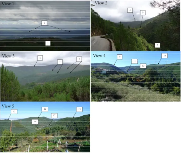
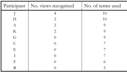
5.1.3 Results from descriptions of Lousã video
The images shown in Figure 3 are the views used in the movie montage of the Serra da Lousã site. The landforms which were named or described by at least one participant have been labelled. A total of 17 landforms were given terms and/or place names by participants.
Appendix 2 contains a summary of the terms used by participants to describe the landforms. The Odemira participants used a total of 18 different terms and the Lousã participants used 30. The Odemira participants used between 4 and 6 terms each (an average of 4.7), while the Lousã participants used between 3 and 14 terms (an average of 6.7).
29
Figure 3. Video views 1 - 5, Lousã
Participant No. views recognised No. of terms used
H 4 14
G 2 11
B 3 7
I 2 7
K 3 6
J 1 6
C 2 5
A 3 4
F 2 4
E 1 3
Table 2. Recognition and number of landform terms for Lousã participants - Lousã video
5.1.4 Results from descriptions of the Odemira video
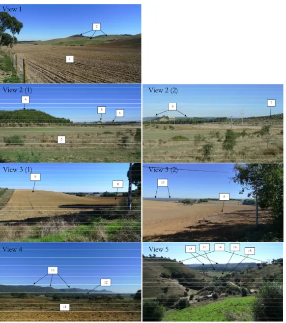
The images shown in Figure 4 are the views used in the movie montage of the Odemira site. The landforms named or described by at least one participant have been labelled. A total of 18 landforms were given terms and/or place names by participants.
A summary of the terms used by participants to describe the landforms in the Odemira video is given in Appendix 2. The Odemira participants used a total of 26
View 1 View 2
View 3 View 4
30
different terms and the Lousã participants used 27. The Odemira participants used between 4 and 10 terms each (an average of 7.5), while the Lousã participants used between 4 and 9 terms (an average of 6.1).
There is a positive relationship between the number of views the participant recognises and the number of terms they use to describe the video. The number of views recognised and the number of landform terms a participant uses has a positive correlation coefficient of 0.74. The data for Odemira participants watching the Odemira video is shown in Table 3 below, ordered from the most number of terms to the least. Many of the Lousã participants recognised the Odemira views as showing the typical Alentejo landscape but did not know the actual location.
Figure 4. Video views 1 - 5, Odemira View 1
View 2 (1) View 2 (2)
View 3 (1) View 3 (2)
31
Participant No. views recognised No. of terms used
J 4 10
H 2 10
A 2 9
K 2 9
G 0 9
C 0 7
E 0 7
I 0 7
F 0 6
B 0 5
Table 3. Recognition and number of landform terms used, Odemira participants - Odemira video
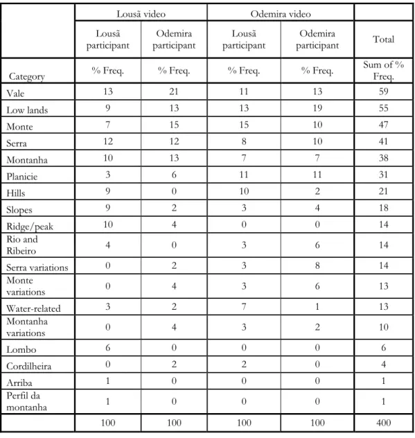
5.1.5 Combined results
32
Lousã video Odemira video
Lousã participant (Total: 10) Odemira participants (Total: 11) Lousã participant (Total: 10) Odemira participants (Total: 11)
No. Category Terms Count % Freq. Count % Freq. Count % Freq. Count % Freq.
1 Low lands
Várzea
6 9 7 13 8 13 16 19
Várzea grande Baixio Baixa
Terreno chão e alagadiço Lezíria Planalto Pequeno planalto Plana
2 Planicie Planicie 2 3 3 6 7 11 9 11
3 Vale Vale 9 13 11 21 7 11 11 13
Vale fundo
4 Arriba Arriba 1 1 0 0 0 0 0 0
5 Monte Monte 5 7 8 15 9 15 8 10
6 Monte
variations
Montezinhas
0 0 2 4 2 3 5 6
Pequeno monte Monte grande
7 Hills Colina
6 9 0 0 6 10 2 2
Morro Cabeço Penedo Elevações Elevaçãozinha 8 Slopes Encosta
6 9 1 2 2 3 3 4
Encostazinha Encosta abruptas Ladeira Inclinado Poco inclinado Inclinação Rampa
9 Serra Serra 8 12 6 12 5 8 8 10
10 Serra
Variations
Pequena serra
0 0 1 2 2 3 7 8
Serrazinha Serrinha Serra maior Serra alta
11 Montanha Montanha 7 10 7 13 4 7 6 7
33
Lousã video Odemira video
Lousã participant (Total: 10) Odemira participants (Total: 11) Lousã participant (Total: 10) Odemira participants (Total: 11)
No. Category Terms Count % Freq. Count % Freq. Count % Freq. Count % Freq. (Continued from previous page…)
12
Montanha variations
Mini-montanha
0 0 2 4 2 3 2 2
Montanha baixa Montanhas suave Montanha pequena Montanha alta 13 Ridge/ peak Cumeeira
7 10 2 4 0 0 0 0
Cume da montanha Cume da serra Cume da encosta Cumeada Pico da montanha
14 Lombo Lombo 4 6 0 0 0 0 0 0
15 Cordilheira Cordilheira 0 0 1 2 1 2 0 0
16 Perfil de
montanha Perfil da montanha 1 1 0 0 0 0 0 0
17
Rio and
ribeiro Rio 3 4 0 0 2 3 5 6
Ribeiro
18
Water-related
Margens do rio
2 3 1 2 4 7 1 1
Passagem de água
Linhas da água Bacia
Total 67 100 52 100 61 100 83 100
Table 4. Aggregation of the landform terms into generalised categories, counts and percentage frequencies of occurrence
34
Lousã video Odemira video
Lousã participant Odemira participant Lousã participant Odemira
participant Total
Category % Freq. % Freq. % Freq. % Freq.
Sum of % Freq.
Vale 13 21 11 13 59
Low lands 9 13 13 19 55
Monte 7 15 15 10 47
Serra 12 12 8 10 41
Montanha 10 13 7 7 38
Planicie 3 6 11 11 31
Hills 9 0 10 2 21
Slopes 9 2 3 4 18
Ridge/peak 10 4 0 0 14
Rio and
Ribeiro 4 0 3 6 14
Serra variations 0 2 3 8 14
Monte
variations 0 4 3 6 13
Water-related 3 2 7 1 13
Montanha
variations 0 4 3 2 10
Lombo 6 0 0 0 6
Cordilheira 0 2 2 0 4
Arriba 1 0 0 0 1
Perfil da
montanha 1 0 0 0 1
100 100 100 100 400
Table 5. Term distribution within each participant group ordered from most to least common
35
Lousã video Odemira video
Lousã participant Odemira participant Lousã participant Odemira participant Lousã participant total Odemira participant total
Category % Freq % Freq % Freq % Freq
Sum of % Freq
Sum of % Freq
Arriba 100 0 0 0 100 0 Lombo 100 0 0 0 100 0 Perfil da
montanha 100 0 0 0 100 0
Hills 43 0 43 14 86 14
Ridge/peak 78 22 0 0 78 22
Water-related 25 13 50 13 75 25
Slopes 50 8 17 25 67 33 Rio and
Ribeiro 30 0 20 50 50 50
Cordilheira 0 50 50 0 50 50
Serra 30 22 19 30 48 52 Monte 17 27 30 27 47 53
Montanha 29 29 17 25 46 54
Planicie 10 14 33 43 43 57
Vale 24 29 18 29 42 58
Low lands 16 19 22 43 38 62
Montanha
variations 0 33 33 33 33 67
Monte
variations 0 22 22 56 22 78
Serra
variations 0 10 20 70 20 80
Table 6. Term distribution between participant groups, ordered from most to least common for Lousã participants (and least to most common for Odemira participants)
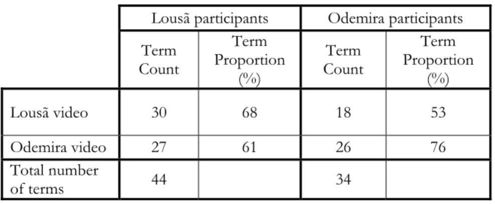
36
Lousã participants Odemira participants
Term Count
Term Proportion
(%)
Term Count
Term Proportion
(%)
Lousã video 30 68 18 53
Odemira video 27 61 26 76
Total number
of terms 44 34
Table 7. Total term counts and frequencies of occurrence per participant group
5.1.6 Water and vegetation in the results
The two most consistently observed commonalities in participants’ descriptions, were the references to water, and the desire to describe the vegetation and land-use. None of the video scenes included any water – no visible sea, rivers, streams, lakes, dams or mud. Despite this, the majority of participants included water-related descriptions of the landscape as an element in the identification of landforms. Many used the water flow paths to describe the shape of the landscape or speculated about where water features may be or may flow, even in landscapes unfamiliar to them. Where used to describe the form of the landscape, the water references have been included in the list of landform terms presented in the previous section [for example,
Linhas da água (water lines), bacia (basin), várzea (plain next to a river), terreno chão e alagadiço (flat and flood prone land) and lezíria (flood plain)]. Additional references included: speaking of certain vegetation as an indication of the presence of water, noting a green patch in a ploughed field as a water point, describing the land cover as
lameiro (marsh, swamp), and guessing that the sea was beyond a background mountain, or that a river flowed in the lowlands.
37
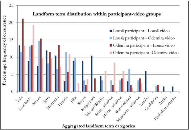
Figure 5. Landform term distribution within participant – video groups as percentage frequency of occurrence
Figure 6. Landform term distribution between participant - video groups as percentage frequency of occurrence
0 5 10 15 20 25 Percentage frequency of occurrence
Aggregated landform term categories
Landform term distribution within participant-video groups
Lousã participant - Lousã video
Lousã participant - Odemira video Odemira participant - Lousã video
Odemira participant- Odemira video
100 100 100
43 78 25 50 30 30 17 29 10 24 16 43 50 17 20 50 19 30 17 33 18 22 33 22 20 22 13 8 50
22 27 29
14 29 19 33 22 10 14 13 25 50
30 27 25
43 29 43 33 56 70 0 10 20 30 40 50 60 70 80 90 100 Percentage freqency of occurrence
Aggregated landform term categories
Landform term distribution between participant - video groups
38
5.2 DEMderived landform classification
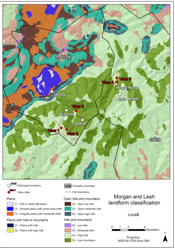
The following maps (Figure 7 and Figure 8) show the results of the computation of Hammond’s macro landform classes using Morgan and Lesh’s (2005) method. The Model builder models used to complete this analysis are shown in Appendix 4.
39
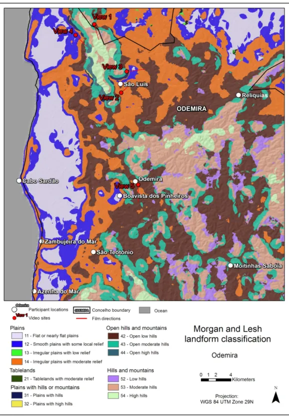
Figure 8. Morgan and Lesh landform classification map with video view sites and participant residence locations, Odemira
40
were identified with the help of a 3D visualisation. The views of the landform classification draped over the DEM 2 1/2 D model are shown in Appendix 6.
Table 8 and Table 9 show the summary of participants’ terms for each Morgan and Lesh class present in the video views. They show the range of participant landforms identified within the zones of each macro scale landform class.
Morgan and Lesh class Participant terms (most to least common)
14 - Irregular plains with moderate
relief Vale, Montanha, Monte
43 - Open moderate hills Vale, Montanha, Monte
53 - Moderate hills Vale, Montanha, Monte
54 - High hills Montanha, Serra, Vale, Ladeira, Cume, Encostas
abruptas
55 - Low mountains Montanha, Serra, Cume/cumeada, Montes
Table 8. Morgan and Lesh landform classes with corresponding participant terms, Lousã video
Morgan and Lesh class Participant terms (most to least common)
12 - Smooth plains with some local relief Planicie, Planalto
14 - Irregular plains with moderate relief Várzea, Planicie, Planalto, Monte, Serra, Rio
31 - Plains with hills Planicie, Monte
42 - Open low hills Serra, Montanha, Monte, Vale
43 - Open moderate hills Monte, Serra, Montanha
52 - Low hills Serra, Montanha
53 - Moderate hills Serra, Montanha
54 - High hills Montanha, Serra