¹Universidade Federal de Santa Catarina – UFSC, Florianópolis (SC), Brasil. E-mail:[email protected] ²Universidade de São Paulo – USP, Departamento de Geofísica, São Paulo (SP), Brasil.E-mail: [email protected] ³Universidade de Brasília – UnB, Brasília (DF), Brasil.E-mail: [email protected]
*Corresponding author.
Manuscript ID: 20170009. Received in: 01/23/2017. Approved in: 03/17/2017.
ABSTRACT: A ground magnetic survey in a Central-East area of the Santa Catarina Island tested the continuity of the Cretaceous ma-ic dykes beneath the aeolma-ic sediments of the Joaquina plain. Vertma-ical gradient measurements taken in 1880 stations did not detect any magnetic anomaly related to subsurface dykes. Four magnetic proiles located to the north and south of the main area showed the magne-tic signature of various dykes some of them already mapped (north proiles), but also some in subsurface (south proiles). hese results suggest that the dykes probably were shallow and truncated, and were already eroded along with the crystalline basement.
KEYWORDS: Dyke swarm; Santa Catarina Island; Geophysical mapping; Ground surveys; Magnetic methods.
RESUMO: Um levantamento magnético terrestre foi realizado numa área do centro-leste da Ilha de Santa Catarina, para veriicar a con-tinuidade dos diques em subsuperfície na área das dunas da praia da Joaquina. Medidas de gradiente vertical em 1880 estações não revelaram nenhum sinal relacionado com anomalias magneticas produzidas por diques em subsuperfície. Quatro peris localizados ao norte e sul da área principal de estudo detectaram a assinatura magnética de vários diques, alguns alorantes (peris-norte) mas também alguns em subsuperfície (peris-sul). Estes resultados sugerem que os diques eram rasos e truncados e foram erodidos juntamente com o embasamento cristalino.
PALAVRAS-CHAVE: Enxame de diques; Ilha de Santa Catarina; Mapeamento geofísico; Levantamentos terrestres; Métodos magnéticos.
Evaluation of maic dyke swarm
continuity under the Joaquina dune
ield with ground magnetic survey
Investigação da continuidade do enxame de diques máicos
sob as dunas da Joaquina usando magnetometria terrestre
George Caminha-Maciel1*, Marcia Ernesto2, Welitom R. Borges3,
Junior Bresolin¹, Reginaldo Lemos1
INTRODUCTION
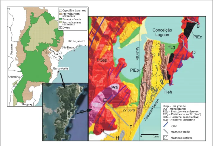
he Brazilian Atlantic coast is cut by Cretaceous dyke swarms (Marques & Ernesto 2004) associated with the Atlantic opening. he most expressive one is the Ponta Grossa dyke swarm trending mainly NW; the other two are NE trend-ing systems: the Serra do Mar swarm to the north, and the Florianópolis swarm to the south (Fig. 1). In spite of their geodynamical importance, there are very few geophysical investigations (Ferreira 1982, Ussami et al. 1991, Stanton et al. 2010) on these dykes which could contribute to a better understanding of its subsurface coniguration and its role in the geodynamical processes of the eastern Gondwana breakup. he Florianópolis dyke swarm is more concentrated in Santa Catarina Island (Fig. 1), but also extends to the adja-cent continental areas. Dyke outcrops are seen all over the island, but the best exposures are found on the rocky shore-lines. In the inner areas, weathering conditions frequently do not allow to infer some important characteristics as the dyke attitude, thickness and length. Furthermore, some parts of the island are covered by recent sediments, hampering the observation of possible lateral continuation of dykes.
In the absence of aeromagnetic data for Santa Catarina Island, a magnetic investigation of the Florianopolis swarm was performed through a ground magnetic survey. However, the island is densely urbanized, limiting this type of investi-gation. Fortunately, some environmental preservation areas are still available, and one of the largest is the dune ield of Joaquina Beach, where this study is concentrated.
GEOLOGICAL SETTING
he maic dykes cropping out in Santa Catarina Island and adjacent continental area (Florianópolis swarm) are related to the Paraná Magmatic Province (e.g. Marques & Ernesto 2004) of Early Cretaceous age, which preceded the South Atlantic opening. Radiometric ages based on the Ar39/Ar40 method yielded ages ranging from 119.0±0.9 Ma to
128.3±0.5 Ma (Raposo et al. 1998), slightly younger than the ages for the Paraná Province (134-132 Ma), associating the dyke swarm to the inal stages of the rifting at those latitudes. However, a U/Pb age of about 134 Ma was reported for one dyke located on the continental side (Florisbal et al. 2014).
Florianópolis
Crystalline basement Pre-volcanism sediments Paraná volcanic Post-volcanism sediments Dykes
P
araguay
Argentina
Uruguay
Rio de Janeiro
São Paulo Ponta Grossa
PGsp – Ilha granite PGi – Monzogranite PIEc – Pleistocene sandstones PIEp – Pleistocene; aeolic (fixed) Heh – Holocene; aeolic (active) HLg – Holocene; lacustrine
Dyke
Magnetic profile
Magnetic stations
0 1km
Chemically, the dikes are mainly basalts with similar com-position to the one of extrusive rocks of the Paraná Province (Marques et al. 1993). Paleomagnetic studies on these dykes (Raposo et al. 1998) showed that they have stable remanent magnetizations of normal and reversed polarities.
he Florianópolis dykes crosscut vertically or sub-verti-cally the Late Proterozoic granitic rocks, and they generally appear truncated, although some can be traced for some kilometers (Tomazzoli & Pellerin 2015). hey trend mainly N30-55°E, but a smaller group trending N15-45°W even-tually cuts the NE group, as seen in Joaquina Beach. heir thicknesses vary from centimetres to 60 m.
Quaternary sediments are deposited in the low areas of the island, forming the coastal plains; aeolic sedimentation forms dune ields on the eastern side — the largest one is in the area of Joaquina Beach, where dunes are as high as 40 m.
GROUND MAGNETIC DATA:
ACQUISITION AND PROCESSING
he magnetic data was acquired using a single unit of proton GSM-19 Overhauser Gradiometer (GEM Systems). he gradiometer measures the variation (vertical gradient – VG) of Earth’s total magnetic ield in two sensors located 50 cm vertically apart; the lower unit being ~200 cm high. he total magnetic intensity (TMI) can also be obtained from one of the sensors.
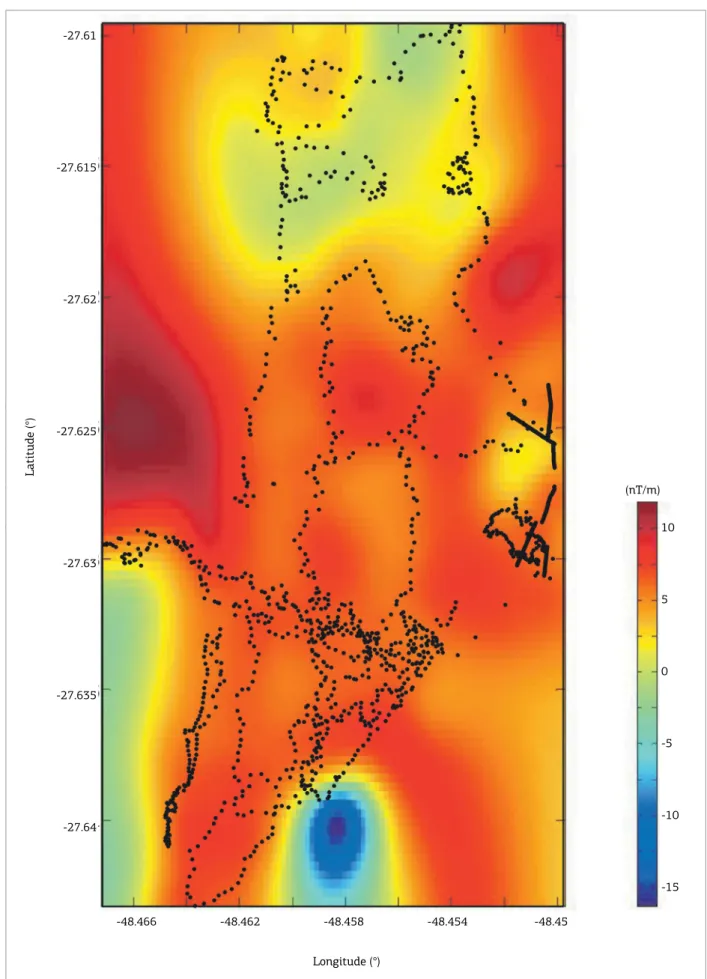
A gradiometric survey was performed all over the dune ield of Joaquina Beach (Fig. 1), and measurements were taken in 1,880 magnetic stations, forming lines with dif-ferent orientations and avoiding relief and wildlife barriers. No base station measurements were necessary for the VG data as they are normally free of diurnal variations — both sensors experience the same temporal variations, therefore being automatically eliminated in the gradient.
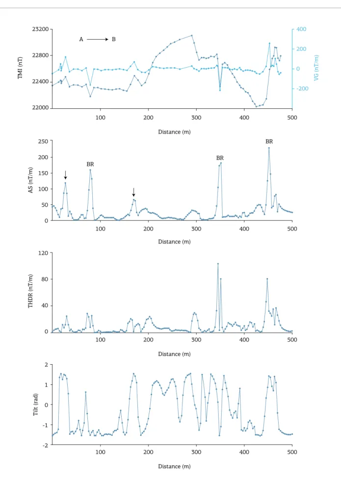
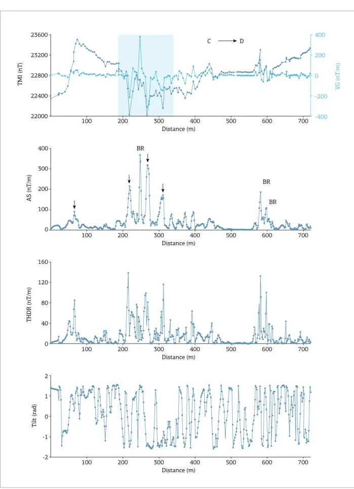
VG and TMI measurements were taken along four pro-iles with general W-E trend — two to the north and two to the south of Joaquina Beach (Fig. 1). In North proiles (Mole beach, A-B proile; Gravatá trail, C-D proile), sta-tions were equally spaced (5 m) along the existent trails in a downhill direction. South proiles (E-F and G-H proiles, to the north and south of the Pedrita Quarry, respectively) were taken on plain terrains, offering easier conditions but showing more human interference. For each proile, a magnetic base station was visited repeatedly at least at the beginning and the end of the survey. A variation curve was constructed for each base station and was used to correct the TMI data for the diurnal variation.
It is also common in magnetic surveys to eliminate the trends of the global magnetic reference ield (IGRF).
However, in the present case, these trends are negligible as the survey area is small and proiles are short-length. Similarly, the regional componentswhich represent long-scale trends, usually related to long-wavelength and/or deep crustal fea-tures, were not considered.
Other useful processing tools are frequency iltering, lin-ear ield transformations (pseudogravity and reduction to the pole – RTP) and the use of magnetic derivatives. Frequency iltering brings the problem of deining a set of cut-of fre-quencies, which is a multiple solution problem; it also var-ies for diferent proiles in a survey, and even along a single proile; those choices are highly critical for short-length data. Linear transformations, particularly RTP, aim to show the magnetic anomaly as if it was originated by a monopolar central ield (like gravity ield); they are meant to minimize interpretation ambiguities due to the dipolar nature of mag-netic ields. However, they present two drawbacks: they are ill deined near the equator, and the magnetization should be induced only — any remanence may cause distortions in the interpreted bodies. herefore, they are not useful in the present processing. he so called magnetic derivatives are derivatives from total intensity values (scalar ield) or from some magnetic vector component (usually estimated from TMI data), and are helpful in enhancing some aspects of an anomaly, related to the possible causative body properties. In this paper, we used the analytic signal (AS), the total horizontal derivative (THDR) and the Tilt angle, as described in Table 1. Some of these derivatives, particularly AS, are little inluenced by the magnetization direction (Maunde et al. 2013, Verduzco et al. 2004). he Florianópolis dykes have strong and variable natural remanent magnetization directions, including normal and reverse polarities (Raposo et al. 1998). hese magnetizations can generate VG higher than 1,000nT/m, as observed over a dyke outcrop in Galheta Beach.
he AS curve has maxima over magnetic bodies and their edges. he THDR and Tilt angle curves were used as
Table 1. Magnetic derivatives applied to the 2D proiles.
Analytic Signal AS= ⎞ +VG2
⎟⎠ ⎛ ⎜⎝δδ
2
T x
Total Horizontal Derivative ⎞
⎟⎠ ⎛ ⎜⎝δδ =
2
T THDR
x
Tilt Angle =arctan⎡⎢⎣ ⎤⎥⎦
x VG Tilt
THDR
auxiliary tools for qualitative interpretation, as the data were not previously RTP transformed, which could bias quanti-tative estimates based on those derivatives.
RESULTS
he VG data over the Joaquina dune area (Fig. 2) showed no magnetic anomalies or signiicant magnetic contrast that could be interpreted as borders of a magnetic body. Most of the area showed VG near zero, and the maximum VG (~5 nT/m), in some particular points, does not show any geometric pattern that could be related to any geologic fea-ture of interest. Also, there are no long-wavelength feafea-tures associated with deep bodies, as can be seen, on the 100 m VG upper continuation (Fig. 3). here are some very weak variations, probably associated to the sedimentary topog-raphy in the area.
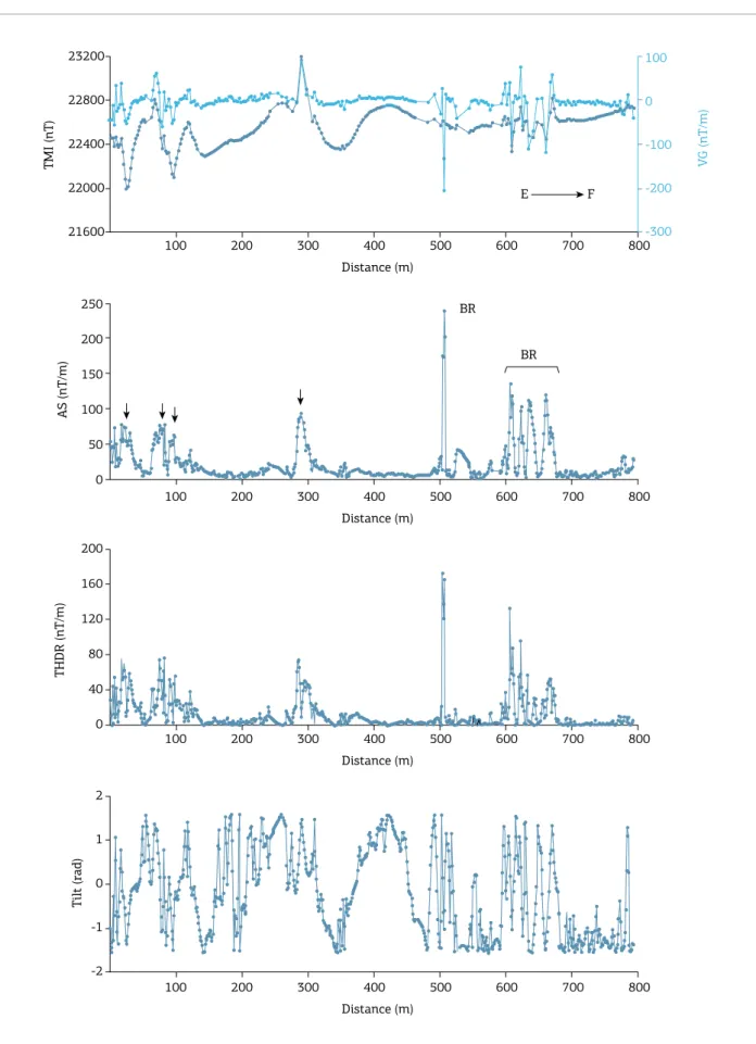
The northern profiles (Figs. 4 and 5) are noisy due to some unavoidable cultural interference (electric power lines, concrete pipe lines, metallic garbage bins etc.), and geological noise generated by variable relief and also rolled rock blocks. The magnetic curves dis-play several anomalies not easily interpretable, although some of them clearly correspond to mapped dykes, as seen on Fig. 1. When the interpretation was straightfor-ward a vertical arrow indicates the dyke anomaly in the AS curves. If resolution was not sufficient for reliable interpretation, the anomaly was coded as BR (below res-olution). The Gravatá profile (Fig. 5) clearly cut some mapped dykes (Fig. 1) in a zone where the survey line changed direction. Coincidently, the magnetic curves are noisy in this area, which may be due to the proxim-ity of various dykes.
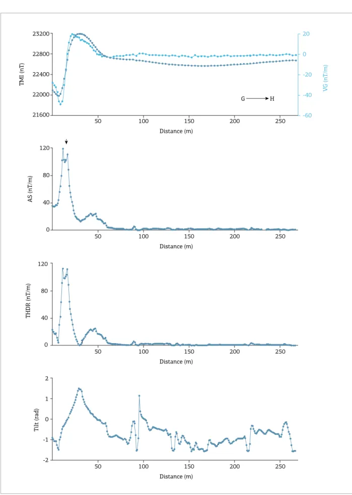
The south profiles (Figs. 6 and 7) were the most favorable ones for the magnetic investigation, as they are in an open and plain area. We found several anom-alies probably related to dykes in subsurface corre-sponding to the continuation of those observed on the geological map (Fig. 1). Between the two profiles, the Pedrita quarry exposes three dykes, two of which are 60 m thick.
DISCUSSION AND CONCLUSIONS
In this reconnaissance survey, we aimed to identify mag-netic anomalies possibly associated to non exposed dykes, which could represent the continuation in subsurface of the geologically mapped bodies close to the Joaquina Beach area. No quantitative interpretation or modeling was performed,
but only estimations of location of possible bodies based on the shape and maxima of AS curves.
Some of the magnetic anomalies were clearly interpreta-ble as dykes, some of which correspond to the continuation of dykes already mapped. On the other hand, other anom-alies were not easily resolved, and further studies would be necessary to better deine these signal sources (e.g. higher resolution ground magnetic surveys, additional geophysi-cal methods, etc.). Some of these “non-resolved” anomalies may correspond to narrow dykes (less than 10-5 m wide), which could not be properly detected in our 5 m spaced magnetic stations.
he gradiometric survey over the Joaquina Beach dunes revealed the inexistence of any magnetic anomalies, as could be expected if at least some of the dykes had subsurface con-tinuation. Considering that usually VG enhances near-surface, small or weakly magnetized bodies, we can conidently say that there are no signiicant magnetic inite sources beneath the Cenozoic sediments in the area. Conversely, the pres-ence of dykes beneath the shallow sediments in the south and north proiles is a reality. However, it must be consid-ered that these proiles are located very close to the granitic bodies cut by dykes, and therefore it is reasonable to expect that the sources should be associated with intrusions in a shallow granitic basement.
Unfortunately, there is no published information about the thickness of the sedimentary column in the Joaquina area, nor about its basement lithology. However, although deep, any existing magnetic source signal would be detected on the surface via the magnetic anomalies they generate. herefore, we conclude that the dykes in the area are all short and truncated. Particularly, it is really surprising that thick dykes like those in Pedrita Quarry show no continuation in the Joaquina plain. herefore, it is reasonable to admit that the dykes are actually shal-low structures, and were removed by erosion along with the host granitic bodies. As an example, one may refer to the model proposed by Valentine & Krogh (2006) for shallow dykes and sills intruded in pre-existing structures beneath a basaltic volcanic centre. A more detailed and speciic geophysical work should be carried out for such an investigation.
ACKNOWLEDGMENTS
-48.466 -48.462 -48.458 -48.454 -48.45
Latitude (°)
-27.61
-27.615
-27.62
-27.625
-27.63
-27.635
-27.64
(nT/m)
10
5
0
-5
-10
-15
Longitude (°)
-48.466 -48.462 -48.458 -48.454 -48.45
Latitude (°)
-27.61
-27.615
-27.62
-27.625
-27.63
-27.635
-27.64
(nT/m)
10
5
0
-5
-10
-15
Longitude (°)
TMI (nT)
23200
22800
22400
22000
Distance (m)
100 200 300 400 500
Distance (m)
100 200 300 400 500
Distance (m)
100 200 300 400 500
Distance (m)
100 200 300 400 500
V
G (nT/m)
A B
AS (nT/m)
250
200
150
100
50
0
BR
BR
BR
THDR (nT/m)
120
80
40
0
T
ilt (rad)
2
1
0
-1
-2
400
200
0
-200
TMI (nT)
23600
23200
22800
22400
22000
Distance (m)
100 200 300 400 500 600 700
Distance (m)
100 200 300 400 500 600 700
Distance (m)
100 200 300 400 500 600 700
Distance (m)
100 200 300 400 500 600 700
V
G (nT/m)
400
200
0
-200
-400
C D
BR
BR BR
AS (nT/m)
400
300
200
100
0
THDR (nT/m)
160
120
80
40
0
T
ilt (rad)
2
1
0
-1
-2
V
G (nT/m)
TMI (nT)
23200
22800
22400
22000
21600
Distance (m)
100 200 300 400 500 600 700 800
Distance (m)
100 200 300 400 500 600 700 800
Distance (m)
100 200 300 400 500 600 700 800
Distance (m)
100 200 300 400 500 600 700 800
100
0
-100
-200
-300
BR
BR
E F
AS (nT/m)
250
200
150
100
50
0
THDR (nT/m)
200
160
120
80
40
0
T
ilt (rad)
2
1
0
-1
-2
Figure 7. Magnetic curves for the south proile (G-H). From top to bottom: total magnetic intensity (TMI), vertical gradient (VG), analytic signal (AS), total horizontal derivative (THDR), tilt angle (Tilt). The arrow on the AS curve indicate anomaly clearly related to dyke.
TMI (nT)
23200
22800
22400
22000
21600
Distance (m)
50 100 150 200 250
Distance (m)
50 100 150 200 250
Distance (m)
50 100 150 200 250
Distance (m)
50 100 150 200 250
V
G (nT/m)
20
0
-20
-40
-60
G H
AS (nT/m)
120
80
40
0
THDR (nT/m)
120
80
40
0
T
ilt (rad)
2
1
0
-1
Ferreira F.J.F. 1982. Alinhamentos estruturais magnéticos da região centro-oriental da bacia do Paraná e seu signiicado tectônico. In:
IPT – INSTITUTO DE PESQUISAS TECNOLÓGICAS DO ESTADO DE SÃO PAULO. Geologia da Bacia do Paraná. São Paulo: IPT,
p.143-166. (Publ. Especial 12).
Florisbal L.M., Heaman L.M., Janasi V.A., Bitencourt M.F. 2014. Tectonic signiicance of the Florianópolis Dyke Swarm, Paraná-Etendeka Magmatic Province: a reappraisal based on precise U-Pb dating. Journal of Volcanology and Geothermal Research,
289:140-150.
Luis J.F. 2007. Mirone: A multi-purpose tool for exploring grid data.
Computers & Geosciences, 33(1):31-41.
Marques L.S., Bellieni G., De Min A., Piccirillo E.M. 1993. O enxame de diques da Ilha de Santa Catarina: resultados geoquímicos preliminares. In: Congresso Brasileiro de Geoquímica, 4. Resumos, p.3-4.
Marques L.S., Ernesto M. 2004. O magmatismo basáltico na Bacia do Paraná. In: Almeida, F.F.M.; Mantesso-Neto V., Bartorelli A., Carneiro C.D.R.; Brito Neves, B.B. (Eds.). Geologia do Continente Sul-Americano. São Paulo: Beca Produções Culturais, p.245-263.
Maunde A., Bassey N.E., Raji A.S., Haruna I.V. 2013. Interpretation of ground magnetic survey over Cleveland dyke of north Yorkshire, England. IRJGM, 3(5):179-189.
Raposo M.I.B., Ernesto M., Renne P.R. 1998. Paleomagnetism and 40Ar/39Ar dating of the Early Cretaceous Florianópolis dike swarm (Santa Catarina Island), Southern Brazil. Earth and Planetary Science Letters, 108(4):275-290.
Stanton N.S.G., Schmitt R.S., Maia M., Galdeano S. 2010. Mesozoic riting structures between Campos and Santos basins, Cabo Frio, Brazil: magnetic and structural analysis. Trabajos de Geología,
30(30):253-260.
Tomazzoli E.R., Pellerin J.M. 2015. Unidades do mapa geológico da ilha de Santa Catarina: as rochas. Geosul, 30(60):225-247.
Ussami N., Kolisnyk A., Raposo M.I.B., Ferreira F.J.F., Molina E.C., Ernesto M. 1991. Detectabilidade magnética de diques do Arco de Ponta Grossa: um estudo integrado de magnetometria terrestre/aérea e magnetismo de rocha. Revista Brasileira de Geociências, 21(4):317-327.
Valentine G.A., Krogh K.E.C. 2006. Emplacement of shallow dikes and sills beneath a small basaltic volcanic center – the role of pre-existing structure (Paiute Ridge, southern Nevada, USA). EPSL,
246(3-4):217-230.
Verduzco B., Fairhead J.D., Green C.M., Mackenzie C. 2004. New insights into magnetic derivatives for structural mapping. The Leading Edge, 23(2):116-119.
Available at www.sbgeo.org.br