Journal of the International Society for the Study of Vernacular Settlements 35
Towards Integrating Rural Vernacular
Settlements in Urban Regions:
A study of Algarve, Portugal
Miguel Reimão Costa
CEAUCP / Campo Arqueológico de Mértola Universidade do Algarve, Portugal
Desidério Batista
Universidade do Algarve, Portugal
Abstract
This paper deals with the vernacular settlements that often exist in the fringes of urban centres and their adaptations and absorptions within the expansions of the urban regions. In many parts of the world, the processes of urban expansions that began with the industrial revolution often led to the integration of rural settlements previously located in the outer rings of cities through adaptations that naturally took place at that time. In the recent decades however, this has become more arbitrary and in many cases have led to the loss of value of agricultural land, vernacular settlements and buildings of significant heritage values. Antagonisms have developed between the urban and rural areas and the value of vernacular settings have played little role in urban metropolitan planning.
Studies of such situations can reveal how vernacular buildings and hamlets could be integrated to urban areas with appropriate development techniques. In such situations, the rural vernacular buildings and settings need to be protected; enabling them to acquire in the diffuse cities the significance that the historic centers achieved in the traditional compact cities, especially in the second half of the twentieth century. In fact, if the conventional antagonism between city and country had become less significant, the vernacular patrimony – as the ecological systems or the old rural paths and property structure – has to be considered as core considerations in urban planning. This paper argues, in this context, that one should make a distinction between the dispersion patterns and the agglomeration patterns in that they raise different questions in the land use transformations.
In order to facilitate the integration of peri-urban vernacular values in metropolitan contexts, it proposes an urban development model based on heritage and landscape which assumes the relevance of appropriating the ecological and cultural structure of landscape as a basic concept of urbanization.
To understand some of the issues inherent in this process, the paper looks at the lower Algarve in southern Portugal. The vernacular settlements in this area becomes important due to the fact that the present regional and municipal plans constrain the building process outside the compact urban areas to those existing rural settlements in its fringe areas.
.
Journal of the International Society for the Study of Vernacular Settlements 36
The issue: Traditional landscape and expansion of cities
An analysis of the processes of city expansions has revealed the importance that traditional landscapes tend to acquire in urban morphology in different circumstances. Urban morphology is inherently tied to the underlying support of the land, a fundamental factor in the creation of architecture and landscape. Besides the ecological matrix, elements such as the road systems, cadastral structure and built rural heritage play a significant role. However, cities are also the result of a succession of cultural adaptations which historically are reflected both in their urbanism and in vernacular and formal architecture.
In this sense, it is essential to understand the city as a structure which results primarily from natural processes (geological and biological evolution) which configure the received form i.e. the ecological structure, subsequently adapted and manipulated by communities who are responsible for the finished form i.e. the cultural structure (McHarg, 1969). In this way, the transformation and expansion of cities follow an “order beholden to prior occupation” which not only owes its shape to the appearance of the physical land and material heritage but also “to a string of compromises between individual rights and the common will” (Kostof, 2001;52). Cities tend to express, through their formal, cultural, functional and symbolic interrelationships, all the qualities of the landscape where these cities are located. Together with this landscape, they form an inseparable whole (Rossi, 1975;189).
In addition to the importance which the underlying organizational lines of rural peri-urban areas can acquire in city design, the unfolding of this process will in many cases include the preservation of rural settlements and buildings within the urban fabric. This is particularly noticeable during times when the continual expansion of cities accelerates, as has happened in different parts of the world from the beginning of the XIX century onwards. During this process, the way in which the integration of buildings once located close to cities, into the urban fabric took place can be associated, for example, with the assimilation of some small hamlets or to the division of agricultural parcels into plots from manor farms.
Background to the issue
Throughout the history of a city, the way in which the structural elements of landscapes reverberated through urban morphology took different forms in different regions. In pre-industrial societies, the human scale and compact form of cities were directly linked to specific places and to well-defined (nutritional, defensive, mobility, energy) limits (Mumford, 1961:424). These limits formed a clear frontier between delimited urban areas and rural continuity. This morphology changed gradually through industrialization, first with the increasing predominance of means of transportation and travel within these areas, and later into a consolidated pattern of spread-out and poly-nucleated cities. Outside the perimeters of urban centers, peri-urban areas of low population density were almost always in transition. Here, many times, these processes juxtaposed and overlapped structures and forms of deruralization and suburbanization.
In this context, society and territory have been subject to rapid and profound transformations, simultaneously showing altered paradigms and processes of developing cities. These include the technological revolutions, the change from a pre-industrial agricultural economy to an industrial and post-industrial economy as well as from a predominantly rural society to an urban one. These are all responsible for a reversal of values and overall processes which have led to the profound transformation of character in rural and urban spaces. In the transition between one form and another, hybrid, changeable, suburban and ‘rurban’ landscapes appear, while rural landscapes experience constant regression and degradation and urban landscape through rapid and unstoppable growth.
Journal of the International Society for the Study of Vernacular Settlements 37
The process of transformations
There are a number of phases through which these transformations take place. In the first phase, the most prominent economic aspects of cities (massification of industrial production and concentration of production means, assembly line production, and mass consumption) oblige cities to adapt to the demands of production, consumption, and commercial exchange. For these purposes, cities need a network of broad communication paths (roads and train tracks) which support urban expansion. In the next phase, there is a generalized shift in the economic structure of societies, with services becoming (with the great and increasing importance of financial services and businesses) the principal agency of development. Cities end up serving as centrifuges for new activities (information and communication technologies, bio-technology, tourism) and trends, resulting in urban mosaics (Indovina, 2004). There is thus a profound alteration in the ways of thinking, producing, using, and managing landscape in general and cities in particular.
This alteration results from the reorganization of socio-economic processes directly related to the development of transportation, the exponential growth of urban population, and the evolution of technology. It translates into the appearance of a new pattern of occupational and spatial organization characterized by the dilation of urban areas and by their recombination on a large scale. Through this process, the mobility of people, goods, and information gains further importance (Ascher, 2001). In fact, the traditional urban growth associated with the patterns of pre-industrial cities is replaced by an emerging pattern of urbanization that includes the bursting of successive urban boundaries and increasing fragmentation, discontinuity, and a diversity of formats and land use.
Transformation and diffuse cities
It is this new format which leads Francesco Indovina (1990) to introduce the concept of diffuse cities as an operational method for recognizing and interpreting this new state of (dis)organization and (de)construction of areas. Indovina (1990) considers the process in Europe equivalent to that in North American suburbs (often termed urban sprawl). The new land structures are associated with a growing diffusion and with the use of private automobiles, as reflected in a significantly increased mobility and expanding, diffuse city limits which originate in and subsist upon automobile-centered cities (Indovina, 1990). Inherent to this new pattern is the process of significantly dispersed buildings, based on the emergence of new types of buildings such as the free-standing single-family home or small business buildings linked to production and services. The conjunction of new forms of mobility and population dispersion determines the location of new buildings and services, within low density urbanizations. These are sales centers either specialized or connected directly with production (retail markets etc.), of business activities and services (consulting, marketing, project), and of services and exchange centers on a metropolitan scale (shopping centers, hypermarkets, large recreational and sports facilities), which Ignasi de Solà-Morales (2002; 99) designate as “containers”.
Emerging areas resulting from this new pattern of spatial organization associated with explosive urban growth are characterized by the following set of phenomena:
i) The presence of conurbation and dispersal of housing and productive activities throughout landscape which are crisscrossed by dense networks of roads and train tracks, permitting easy connectivity between disparate points of the area and guaranteeing high mobility (Boeri and Lanzani, 1992).
ii) A complex system of productive capital, services, settlements, and multi-directional movement dispersed across large areas with spatial configurations which many times do not result in significant features of urban density or intensity (Indovina, 1990).
Journal of the International Society for the Study of Vernacular Settlements 38
iii) Fragmentation of built areas and empty spaces, leading to an overall complex territorial pattern which is frequently modest in quality and in intensity (Detragiache, 2002).
iv) Multiple spatial configurations which correspond to distinct urban and landscape formats such as strada-mercato (market-roads), old and new centers, and interstitial open spaces (Boeri and Lanzani, 1992).
The process configuring “contemporary cities”—a term Secchi (1999) considers the best for the new urban format which includes not only compact and continuous cities but also diffuse and discontinuous cities—can generally be recognized by successive overflowing of city limits, going from historical cities to their present condition of fragmented and diversified locations. This overflow of city limits results in a significant increase in the number and extent of interstitial rural and natural spaces within the new urbanized areas. As a result, the jump in scale from compact cities to diffuse urbanized areas confers on landscape a fundamental role as a structural, referential and qualifying element in emerging cities (Portas, 2003). In this way, open space systems—containing elements of built rural heritage—can support an ecological and cultural urban landscape, ensuring overall functionality and coherence, ecological integrity, cultural identity, and the sustainability of urban regions.
The vernacular architecture and rural heritage in urban regions
Transformation of contemporary cities engulfs the surrounding cultural landscapes, including rural buildings and settlements which are thus subjected to new demands. In many metropolitan areas whereimportant built heritage is still preserved, this poses a critical challenge. The importance of rehabilitating such heritage, and especially the rural vernacular settlements dispersed throughout the landscape has received little attention in the debate about contemporary cities. Generally this debate has centered most insistently on systems of infrastructure, the importance of ecological systems as a matrix, and programmatic aspects and new building structures in the landscape. Sometimes they also deal with formal and organizational aspects which reveal, for example, references to poly-nucleated systems and to self-organizing patterns.
Within the context of urban regions, vernacular settings and built heritage is generally associated with widely diverse typologies. In geographical studies, the description of diverse land occupation systems have been generally organized by contrasting concentrated versus dispersed settlements, taking into account, on a secondary level, the different forms, shades, and combinations of these two basic categories. Therefore, different types of rural vernacular settlements within the areas near traditional urban centers will naturally be decisive in new patterns of occupation associated with the expansion of contemporary cities.
In terms of vernacular architecture, we can distinguish at first glance between small villages and dispersed buildings in the landscape, which present quite distinct issues when they are rehabilitated within the expanding cities. Villages previously located within the areas influenced by compact cities have experienced a profound transformation which occurs when the traditional processes of production fail and villages are progressively integrated into metropolitan systems. This transformation results from a gradual conversion of rural communities rooted in local social environments and restricted territories to urban communities which depend on new conditions of spatial mobility (Rémy and Voyé, 1994). Indeed this is a process that could be compared to what has occurred in historic centers of the traditional cities.
Towards re-deploying the vernacular
It is in this setting that we should consider the importance which old rural villages and hamlets can acquire within the poly-nucleated systems of metropolitan areas, associated with their qualities from heritage value and spatial organization. Indisputably, the role that the rural villages acquire can be compared with that of the “old cities” acquired within expanding cities, in the first half of the last century (Giovannoni, 1995) which were characterized by a preponderance of mobility
Journal of the International Society for the Study of Vernacular Settlements 39
systems. In many cases, the villages tend to regain a new importance and centrality, which can appear in more restricted areas (generic activities) or wider areas (activities which are more specialized and compliment other centers). However, this centrality can become an expression of community identity when they become building centers which new residents could recognize as having significant heritage and spatial values.
Often, the spatial organizations of these villages contrast with the individualized and low density patterns which are typical of an urbanization layout in metropolitan areas. In fact, the shape of public spaces and the organization of buildings in the villages reflect, as mentioned above, a communal way of life with typically strong social ties. The great challenge resulting from the urban rehabilitation of these villages comes precisely from the need to affirm their centrality as collective and social spaces within the new settings. Indeed, it is this purpose that should be considered in rehabilitating vernacular architecture and preserving the urban heritage of the villages. It is stressed that this should be seriously considered in the context of profound cultural transformations associated with diffuse and fragmented cities. In fact, such urban rehabilitations are similar to preserving historical city neighborhoods.
However, there are also the reasons for rehabilitating dispersed buildings (previously associated with agriculture) within urban regions. In many regions, these settlements have played a role in the diversity of construction periods, of organization, and of dimensions acquired due to the characteristics of the agricultural plots where they were located. It is precisely the loss of relevant ties between buildings and agricultural plots which has led in many cases to the transformation of these dispersed patterns inside metropolitan areas. Upon further observation, today some of these areas can be seen to have a significant increase in patterns of dispersal, where new buildings appear next to former rural settlements that were converted into urban residences. The impact of this low density “urbanization” process is, to a certain degree, comparable to the process described earlier in rural villages.
With urbanization, the advantages of close proximity between residences and agricultural plots, which in a traditional settlement characterizes a dispersed population, are replaced by the designation (or the romantic notion) of what is often called a “cottage” occupied by city residents. This tendency to live in the countryside and at the same time near urban centers tends to follow a pattern of low density, previously termed a “lace of country streets” (Alexander, et.al.1977:30). This is characterized by a series of buildings which simultaneously benefit from access to transportation routes into urban centers and from larger rural plots. In some cases, these patterns of low density result from a planning process which covers a significant portion of the suburban areas of many cities, including the reformulation of the cadastral structure and the implementation of diverse infrastructural networks (as is particularly evident in North American suburbs). In other cases, this pattern results from cities constructed over rural landscape, taking over or converting some of their basic structures more or less indiscriminately, ranging from property organization to the conversion of the network of rural roads into distribution channels. Many of the pre-existing buildings are profoundly modified, especially in the areas in which regional plans, seeking to sustain the growth of diffuse cities prohibit the construction of new residences.
In the majority of cases, the transformation or destruction of rural buildings within cities happens in the absence of a careful investigation of their heritage value. This situation is even more reprehensible when the conversion of rural residences into urban residences is almost always compatible with the rehabilitation of pre-existing buildings. Also, the rehabilitation of these dispersed buildings can contribute to a fundamental cultural change within diffuse cities. In fact, the reconversion of traditional architecture and the built heritage of these areas can fill a role similar to that which historical centers filled for compact cities, especially in the second half of the last century. We can include as part of this heritage not just manor farms and smaller hamlets but also convents, traditional buildings linked to the processing of agricultural products, or other rural buildings. Many
Journal of the International Society for the Study of Vernacular Settlements 40
of these areas can add to these groups of buildings, early industrial structures which in most cases presaged a pattern of fragmented and cities spread across wider areas.
In this sense, the rehabilitation of dispersed built heritage within urban regions takes on a quite distinct dimension from that which is typical of historical city centers. The latter essentially represents the value given to a group of buildings associated with spatial continuity, resulting from a belated and difficult process of historicization of urban spaces (Choay, 1994:157). The former makes up, in contrast, a fragmentary structure formed by different examples of vernacular architecture scattered across diffuse cities. This is even more so when the dispersal of the real estate with heritage value occurs within the context of complex patterns, alternating with other construction elements within urban regions.
In reality, the rehabilitation of such heritage should be part of an overall strategy where planning should consider how relevant continuing structures of cultural landscape (within ecological systems) are to new urbanized areas. Rehabilitation within this overall framework of vernacular architecture can thus add to community identity as a result of its integration into cultural landscape as an underlying system essential to the transformation of cities.
An urban development model based on heritage and landscape
Despite these understandings, the current processes of diffuse urbanization often neglect essential infrastructure (railway tracks, public transportation and other urban services, equipment, green spaces for sports and recreation) and are characterized by the alteration of soil use (excessive occupation of space, loss of biological and cultural diversity, degradation of cultural heritage) which thus transforms landscape. These processes eventually fragment and isolate not only natural ecosystems and traditional agricultural systems, but also human settlements. For this reason, the dynamics of urban dispersal must be not only counteracted but also organized and integrated. As Indovina (2004,) states, the “brand image” of new urban and land mosaics demand a strong integration within the context of dispersion.
From this perspective and within the scope of new urban conditions, open spaces are fundamentally important although generally ignored by planning and management processes because they are too big (river courses, orchards and vegetable gardens, forests, etc.) to be turned into parks or gardens, or too small (areas segmented by the urban fabric) to be used for compatible agricultural purposes (Boeri and Lanzani, 1992). At the same time, the inherent economic, cultural, and ecological qualities and potentials of these spaces oblige us to understand and consider them in terms of discontinuity of form and the pulverization of built or not-built spaces which are typical of emerging cities and new land organization. As a result, because urban dispersion produces an increase in and rising complexity of “urban voids” (Solá-Morales, 2002), a strong consensus exists within the scientific community about urban forms and about the integration of ecological principles and natural processes in urban design (Forman, 2001). In order to articulate these, this paper proposes an urban development model based on landscape.
This model presupposes that city planning and design must introduce the functional logic of rural and natural systems. These provide in the long term flexibility and stability to urban spaces and numerous benefits both to society and to Nature (Forman, 2004:47-49). In this context, landscape, integrating the vernacular rural settlements, “*…+ offers a strategy for accommodating and integrating—rather than opposing—urban activities, infrastructure, and architecture, recognizing that sites must adapt and respond to change overtime *…+” which “*..+ has led to a greater understanding of landscape as a model for urbanism *…+“ (Reed, 2005:31). Based on a new culture of landscape, the more we are interested in urban spaces, the more we should be interested in rural and natural spaces. Therefore, the preferred model is to be more attentive to the identity and character of landscape, the interdependence of cities and their hinterlands, and global heritage values, and to seek to increase compatibility between urbanization and landscape.
Journal of the International Society for the Study of Vernacular Settlements 41
Reasons for this model include the different forms and functions both of the countryside and cities which promote inter-articulation and re-establishment of an urban-rural unity by connecting urban systems, ecosystems, and traditional agricultural systems to create a “new metropolis”. In this way, rural and natural spaces can be considered part of inherited cultural heritage, an indispensible element of urban systems. It is no longer possible to understand any part without the others since the cultural matrix must be preserved for how it configures the ecological and cultural structure of urban landscape (Fig. 1).
Fig. 1: Cultural heritage as an element of urban systems Source: Desidério Batista, Miguel Reimão Costa and Miguel Carvalho.
The importance of a model based on landscape assumes the relevance of appropriating the ecological and cultural structure of landscape as a basic concept of urbanization. Through its integration into urban spaces, these structures acquire longevity and coherence. In this way, urban spaces are based on the re-elaboration and re-affirmation of the evolutionary process of city construction through a specific understanding of landscape which confer on these urban spaces their unique identities. This process presupposes identifying “interstitial free spaces” and the elements of built rural heritage associated with these, in order to identify the original qualities and potential within contemporary cities. City planning can thus incorporate agrarian structures (plots of land) and traditional divisions of the landscape (living hedges or walls), networks of vehicular or pedestrian thoroughfares, water systems and hydraulic structures, traditional systems of land use and agricultural settlements, etc. These elements together make up the structure which sustained the historical process of landscape construction and whose (re)discovery is fundamental for the (re)organization and (re)structuring of contemporary city landscape.
In the proposed model, “collective spaces” are considered to be active elements of connection which possess biophysical, productive, aesthetic attributes that can be the basis for new
Journal of the International Society for the Study of Vernacular Settlements 42
activities. From this point of view, these spaces become compatible with urban planning either through the redevelopment of obsolete or abandoned spaces (industrial zones, port zones, marginal spaces such as canal banks, etc.) or through the preservation of pre-existing natural and cultural heritage. The idea of a system of open spaces as a structural and central element of urban regions confirms the importance of an occupational and spatial organization conceived through landscape, as a flexible (as opposed to static, fixed, rigid) “medium,” able to adapt and respond to social changes and demands which arise over time (Reed, 2005). Keeping in mind the regional dimensions of cities, the new paradigms cannot fail to integrate landscape and heritage: landscape as an element which overcomes urban/rural opposition and adds value through environmental quality; heritage, while not exclusive to historical centers nor limited to buildings, as a potentially important stimulus to local and regional economies when incorporated into the profile of cities (Portas, 2005). The diversity which at all levels can characterize built heritage within metropolitan areas, should thus be understood by taking into account how a landscape exists as a system of superimposed layers developed over time, which can be in many cases, contradictory (Latz, 2007, p.165). Take for instance the examples mentioned earlier of dispersed farming hamlets or old factory complexes within peri-urban spaces. The rehabilitation of this heritage cannot result merely from considering its value as a free-standing element, but as integrating this into a whole on a planning level. The definition of this strategy is obviously not straightforward and can result in different options beyond the preservation of unanimously recognized heritage values. What is in any case fundamental is to develop a rigorous and accurate inventory of the heritage of these regions which, from the material to the immaterial, takes into account the different values present.
The application of such a model for considering ecological and cultural structure of landscape as a significant concept to be manipulated through urbanization can be articulated through the following case study. The process of dispersion has been taking place in Lower Algarve where had existed significant heritage buildings and landscapes in a rural vernacular context.
The Lower Algarve in the south of Portugal: A Case suitable for applying the model
Algarve is the southernmost region of Portugal and in geological terms includes three quite distinct zones: the Mountains (Serra), the Hills (Barrocal), and the Coast (Litoral), which can be seen as constituted of different landscape features defined by types of soil, occupation and land use. The area known as the Lower Algarve, includes the Hills (calcareous) and the Coast (alluvial and sand soils). This landscape, characterized by the meeting of sea and land facies is the result of patterns of use which were shaped through centuries by the relationship between a series of civilizations, peoples, generations, and the land itself.
The human occupation of the region was essentially organized around a poly-nucleated and balanced urban structure, mainly located on the coast. Therefore, the continuity of essential economic elements, as well as ecological and cultural equilibrium of this region’s urban, rural, and natural systems have been continuously threatened since the 1980’s. In fact, the last three decades of urban and tourism growth (sea, sun, and golf) and the “modernization” of agriculture, among other factors, has guided the expansion of the regional economy and promoted a real estate development process resulting in a profound transformation of landscape and urban areas in the Lower Algarve. It is this landscape which is analyzed here, in particular the Olhão-Faro-Loulé urban axis (Fig.2). This axis is associated with a process of change characterized not only by heightened ecological and heritage sensitivity, but also by the construction of some large urban and tourism complexes, and by a concentration of economic activities driving regional development.
Journal of the International Society for the Study of Vernacular Settlements 43 Fig. 2: Central Algarve urban growth (Black – until 1980 / Red – from 1980 to 2006).
Source: Batista, 2009
Given a reality which is rapidly changing and still little understood, where the cities are clearly being transformed, the landscape urbanized, and heritage disintegrating, this analysis of the complex dynamics of transformation taking place must be based, first of all, on a description of the land patterns of the Lower Algarve:
i) An intensely urbanized landscape (in a national and regional context) punctuated both by a dense network of medium-sized and small urban concentrations and by a reticulated pattern of dispersed and idiosyncratic growth along historical infrastructures (roads and pathways);
ii) A dense transportation system made up of lines of major highways (international, regional, and municipal) and railways (the Algarve regional line), complemented by a fine network of minor routes (roads and rural tracks);
iii) A linear pattern of commercial locations—a market-road along the national roads which connect the main cities—predominantly built by small companies;
iv) A diffuse pattern of tourism localities with a preference for seaside and the Ria Formosa (lagoon system) areas, predominantly built in low density urbanizations with or without hotels and golf courses, mainly consisting of free-standing single-family houses with private gardens;
v) A rural matrix which continues to be present, although ever more diluted and simplified by the dynamic of diffuse urbanization and by the “modernization” of agriculture;
Journal of the International Society for the Study of Vernacular Settlements 44
vi) An ecological matrix which continues, predating the more intense urbanization processes and the reconversion of agricultural units, although ever more rare and fragmented by the above mentioned dynamics of land use.
The traditional settlement of the Lower Algarve is therefore associated with a significantly hierarchical occupation of land. This includes larger urban centers on the coast, small towns and villages as well as dispersed buildings which extend from the coastal plains in the south to the calcareous hills in the north (Fig.3 & 4). Many different sources dating from, at least, the XV century document the antiquity of this scattering of agricultural hamlets across the landscape. In any case, this dispersed settlement pattern acquired greater importance from the second half of the XIX century, shaped by the changes in property structure which resulted from the rise of Liberalism. If some of the new building complexes are associated with larger property, generally they are connected to small or medium size developments.
Fig.3: Faro Source: M. R. Costa
Fig.4: Faro Source: M. R. Costa
Dispersed buildings in the Lower Algarve include, in this way, a wide variety of types which is the result of not only the playing out of different historical cycles, but also of diverse conditions of production and dimensions of agricultural properties (Costa,2010). Overall, we can describe dispersed vernacular architecture in the Lower Algarve as small-scale architecture, almost always characterized by an accumulation of different buildings within the whole. In these settlements, stone or earth walls are the most common, mostly calcimined, and tile roofs with one or more slopes (Fig.5).
Fig.5: Fornalha, Olhão Source: M. R. Costa
Fig.6: Jordana, Olhão Source: M. R. Costa
Journal of the International Society for the Study of Vernacular Settlements 45
Inside, a typical house of a small rural property frequently has around five or six distinct rooms, including two or three rooms for living quarters (among these the kitchen) and two or three rooms used for agricultural purposes (stables, barn, and granary). The size of these houses is generally considered tiny by current standards. In the cases where these houses are rehabilitated, in the context of the “urbanization” of rural spaces mentioned earlier, the agricultural rooms are regularly converted into living space. In other cases, new structures are added to the pre-existing building, repeating in this way what has been a normal practice in the vernacular architecture of this region. Among the elements most systematically associated with vernacular architecture in the Algarve are ornate chimneys and platbands which extend the facade of the house above roof level (Fig.6). These are characteristic elements of the facade house which became more common from the last quarter of the XIX century onward, a period of significant alterations in Algarve architecture. Besides the features already mentioned, other new elements were the use of color, geometrical compositions in facades with a more regular use of stone frameworks for doors and windows, or the new use of flat roofs frequently associated with vaulted roofs (Fig.7). It is precisely these transformations that characterize the increased density of dispersed settlements since the second half of the XIX century.
It is also from this period onward, that new buildings were increasingly placed along roads which became more and more an expression of the modernity to which many houses aspired (Fig.8). This linear alignment along roads, tending to increase closer to the major urban centers appeared both on less important rural roads, as well as on more important regional axes. The profound alterations made to many of these axes in recent decades have resulted in the demolition of many traditional roadside houses. These demolitions take place not only to widen roads but also to make room for new building genres which affirm the market-roads referred to earlier. These roads, even so, are still characterized by the presence of a significant number of traditional buildings, almost always vacant, which show different periods of the gradual occupation process along these routes.
Fig.7: Caliços, Olhão Source: M. R. Costa
Fig.8 Valados, Faro Source: M. R. Costa
Generally, traditional buildings scattered across the landscape or aligned with roads were integrated, as discussed above, within small or medium-sized farms. Some of these buildings are therefore connected with quite large farms of the Algarve region. It is the very organization and scale of these settlements that reveal the importance they used to have in the region, including quite large agricultural outbuildings or even housing for salaried farm workers. In many cases, these are settlements which were intensely reformed in the second half of the XIX century and the first half of the XX century. These reforms frequently revealed a more industrial approach in their organization and in the size of the new buildings and rural constructions which were added to pre-existing structures.
Journal of the International Society for the Study of Vernacular Settlements 46
It is because of these characteristics and of the very size of the properties that currently some of these settlements have become particularly suitable for different uses open to the community, through both public and private projects. In contrast to dispersed buildings on small properties which are almost always rebuilt to function as houses, these larger building clusters can acquire other functions within contemporary cities, as has already happened in some cases. We should point out among these groups the “manor farms” (quintas) with their privileged locations near consolidated urban centers (Figs.3, 9, & 10). Manor farms can be found in various regions of Portugal, especially in more productive zones around the major urban centers. These manor farms are notable for a more well-formulated architecture which tends to follow different regional variations and historical periods.
Fig.9: Horta dos Macacos, Faro Source:M. R. Costa
Fig.10: Quinta do Rosal, Loulé Source: M. R. Costa
Fig.11: Quinta da Várzea, Loulé Source: M. R. Costa
Fig.12: Estoi, Faro Source: D. Batista
Many of the themes which characterize dispersed traditional architecture are also visible in the old centers of rural villages (Fig.12). Naturally, here the gradual process of expansion of houses takes place within a small, well-defined plot of land, resulting many times in height increase (Fig.13). Regardless, we find in these centers the same diversity of types of roofing and construction systems mentioned above for dispersed buildings. Also the internal spatial organization is analogous to houses scattered across the landscape (especially in single-story buildings), with the kitchen often located in the back of the house and the living room and bedrooms often laid out along the front. In multi-storey buildings, the kitchen, the stables, the agricultural annexes and storerooms occupy the ground floor.
Journal of the International Society for the Study of Vernacular Settlements 47
The need for larger areas for these agricultural functions frequently led to the presence of large archways in the structural walls, a very characteristic solution found in the historic centers of the major cities of the Algarve. For the slab of the upper stories, there are wooden floors, tiles laid over wood beams, or vaulted structures. These last two types of construction are often linked also to roof terraces (açoteia), especially common in the central region of the Lower Algarve (urban axis of
Olhão/Faro/Loulé). Therefore, the roof terraces tend to alternate within a single building with tiled
roofs (of one or more slopes), so that the houses of these centers preserve the different types of roofing which are typical of dispersed buildings in the central zone of the Lower Algarve.
The old rural centers have also been subject to profound alterations, resulting in both the slow loss of their rural setting and in the changed roles which they tend to acquire in the urban region of which they are now a part. During this time period, the rural centers have been emptied of their traditional, primarily agricultural, communities, following a process in many ways identical to that described generically by Rémy and Voyé (1994:147-151). We can say that among the reasons underlying this mutation is the loss of importance and the transformation of agricultural activities, or the preference of farmers for living on their own agricultural lands. In the specific case of the Lower Algarve, the traditional rural villages continue to have residents who are descended from the former owners (and who are already not necessarily linked to agricultural activities). On the contrary, the most recent expanding areas around these centers primarily house people who have no previous connection whatsoever with these rural villages.
In any case, a considerable number of houses in these old centers are vacant today. In some cases, it is possible to find an analogy between the old centers of these rural villages and a large number of historic centers of the region’s major cities. If the areas of expansion defined by Urban Plans come to contain new residential areas, the historic centers will gradually empty out and experience a drop in residential population. Efforts to rehabilitate the old rural village centers are still timid, even though many of these have long been defined, by Urban Plans, as centers with a heritage character worth preserving (Fig.14). In addition, these villages have not, until now, been able to build up a network of complimentary functions, at a time when many features of diffuse cities are gaining strength in the Lower Algarve.
Fig.13: São Brás de Alportel Source: M. R. Costa
Fig.14: São Brás de Alportel Source: M. R. Costa
Regional and Urban Plans and the Management tools in place for the areas discussed here have sought, in the meantime, to restrict the process of urban growth to areas inside city limits, citing as decisive reasons the fragmentation of landscape or the high cost per home associated with diffuse urbanization. Outside of city limits, these planning tools tend to prevent the construction of new housing on plots without registered urban buildings, allowing only the rebuilding and expansion
Journal of the International Society for the Study of Vernacular Settlements 48
of pre-existing buildings. On this basis, the dispersed buildings of the rural Lower Algarve will eventually acquire an importance in the real estate market which does not arise specifically from their intrinsic value but from a permission to rebuild. These premises are not, in the meantime, associated with any system of inventory or protection of rural built heritage, so that they can lead to the destruction of traditional building clusters. In this way they leave the real estate promoter free rein to decide between rehabilitating and completely replacing the old with new architecture.
In fact, the protection of built heritage in rural areas has occurred essentially in the classification of monumental features, including religious, military and archaeological heritage, but rarely including housing, as can be seen from the inventory of protected heritage in the Algarve (Igespar, Ministry of Culture). In this sense, the heritage maps which are being produced in very few districts of Portugal may represent a first step towards defining a strategy for protecting rural heritage.
In any case, even if real estate pressures come to focus heavily on the value for pre-existing buildings plots, the protection and rehabilitation of this heritage will only make sense when it is part of a wider strategy that considers, in detail, the factors and values of the overall cultural landscape. An inventory of different types of rural settlements should thus be interpreted in the light of the particular history of the landscape, distinguishing, for example, the manor farms of the Ancièn Regime from dispersed groups of small properties of the second half of the XIXth century onwards. In this way, different levels of preservation can be introduced, favoring the protection of some properties while considering the relationship between type of building and farm organization.
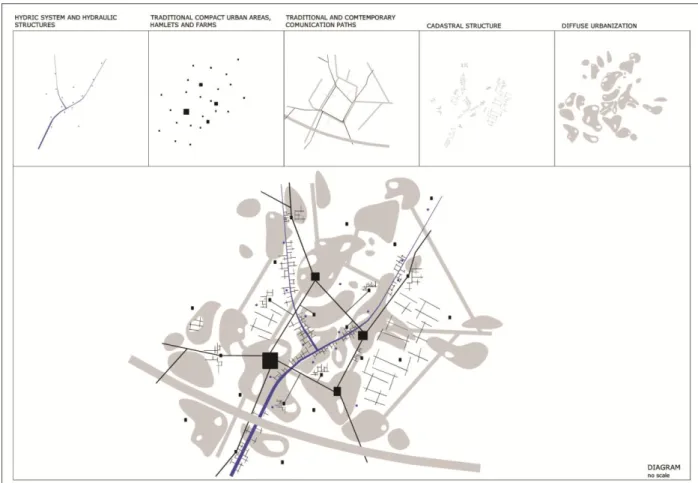
Fig.15: Proposed model. Olhão /Faro/Loulé Urban System Source: Batista, 2009.
Journal of the International Society for the Study of Vernacular Settlements 49
The new reality of urban regions is characterized by a generalized disorganization and by the absence of a clear image of city. It is constantly changing, where the ever more diffuse urban spaces transform themselves and the rural systems (dry or irrigated traditional orchards, vegetable gardens, vineyards) and natural systems (marshes, dunes, forests, furze-fields) are being urbanized. Urban values and rural values tend to overlap confusingly, neither producing a feeling of being in the city nor in the countryside, and result in a profound crisis of identity in landscape (Batista, 2009; 229).
When confronted thus by the current configuration of landscape characterized by heterogeneity and widespread spatial discontinuity, the aforementioned ecological and rural matrices should be allowed to play a key role in the regeneration and management of urbanized landscape in the Lower Algarve. These matrices are needed for their formative and regenerating function in this urban region and for use in a strategy of (re)urbanization using landscape and heritage as paradigms. They can be (re)constructed via a system of open spaces and associated elements of rural built heritage, based on the re-valuing of natural and cultural structures and elements. The ecological and rural matrices can thus accompany and organize the processes of inter-city connectivity, formalizing the heritage structure of the overall Lower Algarve landscape.
This heritage structure is understood as a sustainable system of the “new landscape”, analyzing the identity and character, as well as the potential and biophysical, aesthetic, and social attributes of each part of the landscape. It is a response to the processes of urban expansion, promoting the protection of rural and natural spaces, saving natural and cultural heritage, and developing a network of cultural pathways which permit an enjoyment of regional cities. A heritage structure with cultural, economic, and ecological functions becomes in this way a central player in the (re)organization and (re)structuring of contemporary cities. It confers functional coherence and logic to the urban fabric, ecological and cultural integrity to the landscape mosaic, and visibility and utility to rural vernacular settlements.
From this perspective, we propose the following fundamental strategic approaches: i) Defining the model of urban development to be used constituting one of the most important strategies in the conservation and enhancement of landscapes and of built rural heritage. As opposed to the process of fragmented urban expansion and dispersed building across areas of land, the proposed model should rest on polycentricism as an organizing principal of the Lower Algarve urban system. Old centers, both medium-sized and small, and new centers should adopt a strategy of limited and concentrated urban growth. This strategy will allow urban development inside hamlets or in nearby areas (restricted to ecologically suitable building). In this way, it will be possible to encourage the protection of ecologically valuable land (wet areas, marshes, dunes, furze-fields, forests) and/or agricultural land (areas next to watercourses), and the conservation of built rural heritage and hydraulic heritage (water wheels (noras), water tanks, aqueducts, stone gutters).
ii) In association with interpretation and intervention in urban systems, the new urbanized lands attribute to open spaces should play a key role in the regeneration and restructuring of contemporary regional cities. The proposed (re)construction of systems of interstitial spaces should be based on the revaluation of undervalued cultural and natural structures and landscape elements (traditional urban centers, vernacular and formal architecture linked to agricultural production, dry or irrigated orchards, vegetable gardens and vineyards, groves and hedgerows, watercourses), all of which then order and modify the processes of inter-city connectivity.
iii) The defense and preservation of non-urbanized areas and the protection of traditional poly-culture lands (diversified agricultural mosaics) should form one of the fundamental strategies for ecological and socio-economic sustainability in the Lower Algarve. The development and incentives for agriculture in this area can be based fundamentally on the
Journal of the International Society for the Study of Vernacular Settlements 50
creation of the Agricultural Park (Parque Agrícola) of Campina de Faro - Olhão (set apart for horticulture, fruit growing, floriculture, viticulture). Located in the heart of an urbanized zone, this park would be made up of traditional agricultural systems, private and public urban vegetable gardens, pedagogical farms (quintas), etc. Besides ensuring production of food and contributing to the physical stability, ecological balance, biological and culture diversity, as well as the beauty and recreational possibilities of the landscape, this park will support the development of culture and of memory, and ensure historical continuity in the Algarve.
iv) The rehabilitation of built heritage should be examined within an overarching system which connects the most relevant rural heritage to the historical centers of concentrated cities (Faro, Olhão, Loulé). This rural heritage should include such elements as the
aforementioned hamlets, manor farms (quintas) on the periphery of major cities, dispersed traditional buildings, hydraulic heritage (very rich in this area), production architecture (windmills, wine and olive oil presses), and pathways, among other examples of dispersed construction in this landscape. We propose that a structure or network of heritage should be preserved, constituting a system of reference for contemporary cities and encouraging local and regional socio-economic related to the preservation of this heritage, specifically those connected with new areas of tourism (rural tourism, eco-tourism, etc.).
v) Our proposal places particular importance on the rehabilitation of historical centers of old rural population centers. The built and urban heritage of these hamlets acquires relevance in that they make up a network of secondary centers on a regional urban level, playing an important role in social ties. In some cases, this reality is already today especially noticeable on market and festival days, or during other social and cultural events when residents come together both in the villages and in the surrounding areas, thereby creating stronger and more cohesive communities.
vi) We further urge that different degrees of preservation and rehabilitation of dispersed vernacular heritage be established, based on a real understanding of this heritage. From the beginning, this process will necessarily be connected to a systematic inventory of diverse kinds of heritage. The definition of different preservation categories should be equated with not only the absolute value of this heritage but also its place in overall heritage on a regional urban level. In most cases, these definitions should help maintain the private use of heritage (conversion of abandoned buildings into new residences, for example). In exceptional cases only should the conversion of this heritage for public use be considered, making it part of the network of contemporary city facilities.
References
Ascher, F. (2001) Les nouveaux principes de l´urbanisme. La fin des villes n´est pas à l´ordre du jour. Paris: Éditions de l´Aube.
Alexander, C. Ishikawa, S. and Silverstein, M., (1977) A Pattern Language: Towns, Buildings, Construction. New York: Oxford University Press.
Batista, D. (2009) Paisagem, Cidade e Património. O Sistema Urbano Olhão – Faro – Loulé. Propostas para uma estratégia de intervenções integradas de requalificação urbana e valorização ambiental. Ph. D. Universidade de Évora (Portugal).
Boeri, S. and Lanzani, A. (1992) Gli orizzonti della cittá diffusa. Casabella, 588. Milan: Mondadori, pp.44-59.
Journal of the International Society for the Study of Vernacular Settlements 51
Costa, M. (2010) Alguns temas para a interpretação dos assentamentos rurais no sul de Portugal. In: As Idades da Construção. Lisboa: Instituto do Emprego e Formação Profissional, pp. 92-107.
Detragiache, A. (coord.) (2002) Dalla cittá diffusa alla cittá diramada. Milan: Franco Angeli.
Forman, R. (2001) The Missing Catalyst Design and Planning with Ecology Roots, In: B. Johnson, and K. Hill, (ed) Ecology and Design. New York: Island Press, pp.85-109.
Forman, R. (2004) Land Mosaic for the Greater Barcelona Region: Planning a Future. Barcelona: Gustavo Gili, p.47.
Giovannoni, G. (1995) [1931]. Vecchie città ed edilizia nuova. Milano: CittàStudi.
Indovina, F. (1990) La cittá diffusa. In F. Indovina, et. al. La Cittá Diffusa. Venecia: DAEST-IUA, pp.19-43.
Indovina, F. (2004) The metropolisation of the territory. New territorial hierarchies. In: A. Font, ed. The Explotion of the City. Barcelona: COAC-UPC, pp.20-47.
Kostof, S. (2001) The city shaped. Urban patterns and meanings through history. London: Thames Hudson.
Latz, P. (2007) Rehabilitación. In: D. Colafranceschi, ed. Landscape + 100 palavras para habitarlo. Barcelona: Gustavo Gili, pp. 165-167.
McHarg, I. (1969) Design with Nature. New York: John Wiley & Sons. Mumford, L. (1961) The City in History. New York: Harcourt, Brace & World.
Portas, N. (2005) Os Tempos das Formas. Vol. 1: A Cidade Feita e Refeita (Escritos 1963-2004). Guimarães: DAA – Universidade do Minho.
Portas, N. Domingues, A.; Cabral, J. (2003) Políticas Urbanas. Tendências, estratégias e oportunidades. Lisboa: Fundação Calouste Gulbenkian.
Reed, P. (2005) Groundswell: Constructing the Contemporary Landscape. New York: The Museum of Modern Art.
Rémy, J. and Voyé, L. (1994) A Cidade: rumo a uma nova definição? Porto: Afrontamento.
Secchi, B. (1999) Cittá moderna, cittá contemporanea e loro futuri. In: G. Dematteis, et al. I futuri della cittá. Tesi a confronto. Milan: Franco Angeli, pp.41-70.
Rossi, A. (2001) [1966]. A Arquitectura da Cidade. Lisboa: Cosmos. Solà-Morales, I. (2002) Territorios. Barcelona: Gustavo Gili.
Miguel Reimão Costa is a researcher of CEAUCP/Campo Arqueológico de Mértola. He is Professor Auxiliar, Faculdade de Ciências e Tecnologia, Universidade do Algarve, Campus de Gambelas, 8000-062 Faro, Portugal and can be contacted at [email protected]
Desidério Batista is Professor Auxiliar, Faculdade de Ciências e Tecnologia, Universidade do Algarve, Campus de Gambelas, 8000-062 Faro, Portugal and can be contacted at [email protected]