FACULDADE DE CIÊNCIAS
Departamento de Biologia Animal
Landscape changes in Castro Laboreiro:
from farmland abandonment to forest regeneration.
Patrícia Rodrigues
Dissertação de Mestrado
Mestrado em Biologia da Conservação
FACULDADE DE CIÊNCIAS
Departamento de Biologia Animal
Landscape changes in Castro Laboreiro:
from farmland abandonment to forest regeneration.
Patrícia Rodrigues
Dissertação orientada por: Doutor Henrique Miguel PereiraDissertação de Mestrado
infatigável se explica, porquanto a paisagem é sem dúvida anterior ao homem, e apesar disso, de tanto existir, não se acabou ainda. Será porque constantemente muda: tem épocas no ano em que o chão é verde, outras amarelo, e depois castanho, ou negro. E também vermelho, em lugares, que é cor de barro ou sangue sangrado. Mas isso depende do que no chão se plantou e cultiva, ou ainda não, ou não já, ou do que por simples natureza nasceu, sem mão de gente, e só vem a morrer porque chegou o seu último fim.
Resumo ………... 9 Abstract ……….. 13 Introduction ………... 15 Methods ………... 19 Study area ………... 19
Landscape characterization and interpretation ………. 21
Data analysis ………. 21
Land cover changes and landscape structure ……… 21
Patterns in oak regeneration and abandonment of fields ……… 23
Results ………... 27
Land cover changes and landscape structure ……… 27
Patterns in oak regeneration and abandonment of fields ………... 30
Discussion ………... 37 Final Remarks ………... 41 Acknowledgments ………. 43 References ……….. 45 Appendices ………... 52
As regiões montanhosas representam importantes áreas para a conservação da biodiversidade, sendo igualmente vitais para grande parte da população humana, que depende dos bens e serviços prestados pelos ecossistemas de montanha (MA 2005, Schuler et al. 2004). Na Europa, as regiões montanhosas evoluiram durante milénios sob intervenção humana, com a agricultura e a pastorícia a desempenharem um papel fundamental na definição dos ecosistemas de montanha (Blondel 2006, Mitchley et al. 2006). Nas últimas décadas, muitas destas regiões têm sofrido importantes transformações nas suas paisagens, como consequência do êxodo rural das populações e do consequente abandono das actividades agro-pastoris tradicionais (Rey-Benayas et al. 2007). Na freguesia de Castro Laboreiro, situada na região do Minho (NW de Portugal – Figura 1) o abandono agrícola teve ínicio na década de 50, despoletado por diversas forças motrizes de natureza socioeconómica (Lima 1996). Em 1929 foi lançada no país a Campanha do Trigo, que beneficiava sobretudo as regiões do Sul. Segundo Graça (1996), a região Sul recebeu entre 1935 e 1959, cerca de 84% dos fundos para a lavoura nacional, o que contribuiu para a marginalização das áreas agrícolas do Norte. Com a abertura das portas para a emigração, que se encontravam fechadas desde a II Guerra Mundial, iniciou-se o êxodo da população (Barreto 2002).
Como parte integrante do Parque Nacional da Peneda-Gerês, a freguesia de Castro Laboreiro representa um lugar de particular interesse para a conservação da natureza. A sua paisagem apresenta uma enorme diversidade de habitats, onde se destacam as manchas de carvalhal galaico-português (Quercus robur e Quercus pyrenaica), das mais emblemáticas e melhor conservadas do país (2006a). A rotina pastoral dos habitantes da vila organizava-se em torno de um sistema único de alternância de residência, entre as localmente designadas brandas e inverneiras (Geraldes 1996, Lima 1996). Durante a Primavera, Verão e Outono as populações permaneciam nas povoações serranas mais elevadas, no planalto (brandas) regressando ao vale (inverneiras) para o Inverno (Geraldes 1996). Actualmente, a maioria das inverneiras da área de estudo encontra-se abandonada.
A forma como a paisagem evolui em resposta ao abandono depende de muitos factores, mas principalmente das características da área abandonada (tipo e intensidade da acção anterior ao abandono), das condições para a ocorrência da sucessão ecológica e dos respectivos padrões de regeneração da vegetação, dos regimes de perturbação dominantes na área e das escalas
mais comum do abandono agrícola é a modificação do mosaico da paisagem, devido à substituição das áreas abandonadas por áreas de matos e floresta, o que em Castro Laboreiro representa uma oportunidade para a regeneração e expansão da floresta de carvalhal, de elevado valor para a conservação da biodiversidade. No presente trabalho analisamos as alterações da paisagem de Castro Laboreiro entre 1960 e 2007 com especial foco nas alterações ocorridas nas áreas agrícolas e nas áreas de carvalhal. Incidimos a nossa abordagem em três questões principais: (i) está a expansão das florestas de carvalhal a ocorrer na área? Se sim, a que taxa?; (ii) que factores ambientais estão a actuar no processo de regeneração da floresta? e (iii) que factores ambientais influenciam o abandono dos campos?
A evolução da paisagem foi analisada através da interpretação de fotografias aéreas e de ortofotos da área de estudo, registadas nos anos de 1960, 1990 e 2007. Utilizou-se a técnica de actualização regressiva para a interpretação das imagens, e as cartas de ocupação do uso do solo para os anos de 1990 e 2000 (IGEO 1990 e PNPG 2000a) para auxiliar a foto-interpretação. Foram definidas 8 categorias de uso do solo (área agrícola, carvalhal, pinhal, matos baixos, matos altos, rocha, água e aldeia – Tabela 1) e foram produzidos 3 temas vectoriais, um para cada ano analisado. Para medir as taxas e a direcção das alterações ocorridas – questão (i) - derivámos 3 matrizes de transição, uma para cada intervalo de tempo (1960-1990, 1990-2007 e 1960-2007) e construímos um diagrama de trajectórias (1960-1990-2007), através da intersecção dos temas vectoriais. As análises foram efectuadas em ArcMap 9.3 (ESRI). Aplicaram-se várias métricas para a análise da estrutura da paisagem, usando o programa Fragstats v.3.3(McGarigal et al. 2002).
Para responder às questões (ii) e (iii) realizámos uma série de regressões logísticas, usando como variável resposta a ocorrência ou não de transição e como variáveis predictivas os atributos ambientais da paisagem. Realizámos dois tipos de análise: (A) focando a regeneração de carvalhal, em que a transição pode ocorrer de campos agrícolas, matos baixos ou matos altos para carvalhal; (B) focando o abandono dos campos agrícolas, em que a transição ocorre dos campos em uso para campos abandonados. Como atributos ambientais da paisagem seleccionámos as seguintes variáveis: altitude (ELE), declive (SLO), orientação (ASP), distância à àgua (dWAT), distância à fonte de sementes de carvalhal mais próxima (dOAK), distância à estrada mais próxima (dROAD), distância à aldeia mais próxima (dVILL), e fogo (FIRE). As análises foram efectuadas à escala da paisagem e à escala das brandas e inverneiras (ver detalhes
na Tabela 2). A selecção dos modelos mais parsimoniosos foi baseada no critério do AIC mais reduzido e a área sob a curva ROC foi seleccionada como medida de desempenho dos modelos. As análises foram efectuadas no programa R (R Development Core Team 2010).
A paisagem de Castro Laboreiro tem sido dominada por matos baixos e rocha, que em conjunto representam cerca de 65% da área analisada. Os resultados sugerem importantes transformações na paisagem entre 1960 e 2007, sendo a alteração mais significativa a redução das áreas agrícolas, que registaram um declinio de 52% face à àrea ocupada em 1960. Os matos altos aumentaram em 68% a sua representação na paisagem. Já as áreas de floresta de carvalhal registaram um aumento muito modesto (cerca de 4%)(ver Tabela 3 e Figura 2). O primeiro intervalo do estudo, (1960-1990) foi caracterizado por uma diminuição substancial da área agrícola (Anexo Ia), e o segundo período (1990-2007) foi marcado pela expansão de matos altos (Anexo Ib) e por uma tendência para a estabilização da paisagem (ver diagonal da matriz Anexo Ib).
O abandono das áreas agrícolas entre 1960 e 2007, ocorreu em simultâneo com o declínio populacional na freguesia (Figura 3) e as áreas abandonadas foram naturalmente substituídas por áreas de matos altos (dominados por giestas - Cytisus sp.)(Figura 4). As giestas eram usadas para alimentar e forrar as camas do gado e para a produção de estrume. O estrume era aplicado nos campos, o que poderá ter criado um banco de sementes, promovendo a conversão directa dos campos abandonados para giestal (Eastbrook 1994). As métricas de paisagem aplicadas mostram uma tendência para a homogenização da paisagem, onde a distribuição espacial dos campos agrícolas exibe uma tendência para a fragmentação e para a simplicação da forma dos patches (Tabela 4), e as áreas de carvalhal uma tendência para a agregação dos patches e para a complexificação das suas formas (Tabela 4).
Na análise da regeneração da floresta, um dos padrões mais óbvios detectados foi a relação negativa com a distância à fonte de sementes de carvalhal mais próxima (dOAK). Esta foi uma variável estatísticamente siginificativa em todas as análises de regeneração da floresta (quer à escala da paisagem, quer à escala das brandas e inverneiras), indicando que quanto menor for a distância à fonte de sementes, maior é a probabilidade de regeneração da floresta (Tabela 5). O mesmo padrão foi encontrado nos estudos de Gellrich et al. (2007) e Tasser et al. (2007). As variáveis topográficas orientação e declive também demonstraram um efeito sigificativo na regeneração da floresta. Na transição de campos agrícolas abandonados para
carvalhal, a relação positiva encontrada com o declive aponta para um abandono preferencial dos campos agrícolas localizados em terrenos declivosos (Tabela 5). Quanto ao efeito do fogo, este apenas mostrou ser significativo na transição de matos baixos para carvalhal, indicando uma maior probabilidade de regeneração das áreas não ardidas (Tabela 6).
Em relação ao abandono dos campos, os resultados apontam para um efeito positivo da altitude, do declive e da distância à aldeia na probabilidade de abandono (Tabela 7). Assim, os campos agrícolas localizados a altitudes mais elevadas, com declives mais acentuados e mais distantes das aldeias têm maior probabilidade de serem abandonados. Estes resultados estão de acordo com os obtidos por Sluiter e M. de Jong (2007) na localidade de Peyne, França. A análise à escala das brandas e inverneiras permitiu detectar padrões que não são visiveis à escala da paisagem. Contrariamente ao que seria de esperar, os resultados mostram que proporcionalmente houve mais abandono agrícola nas brandas do que nas inverneiras, o que indica que apesar de abandonadas, alguns campos ainda são mantidos nas inverneiras. A menor altitude e as características do solo nas inverneiras permitem o cultivo de culturas diferentes (árvores de fruto e hortas) daquelas que são cultivadas no planalto (centeio e batata)(Geraldes 1996).
A expansão da floresta em Castro Laboreiro foi muito modesta (+4%) quando comparada com outros estudos europeus em áreas de montanha (e.g. Roura-Pascual et al. (2005) identificaram um aumento de 19% na área de floresta no Maciço-Este dos Pirinéus Espanhóis e Conti e Faragazzi (2004) um aumento de 17% no Alpes Italianos). Uma das explicações prende-se com o erro associado à interpretação e classificação das imagens, onde cerca de 35% das áreas intepretadas como matos altos correpondem a carvalhal, levando a uma possível subestimação da área total de carvalhal.
Tendo em conta a tendência populacional de Castro Laboreiro nos últimos 50 anos, é razoável assumir que o abandono irá continuar, bem como a regeneração das áreas de matos e floresta. O aumento das áreas de matos, conduz ao aumento do risco de incêndios, representando um desafio para a adopção de medidas de gestão adequadas.
ABSTRACT
Many European mountain areas are facing important changes in their landscapes due to farmland abandonment. This process favors the natural progress of ecological succession, therefore representing an opportunity for forest regeneration. In Portugal, farmland abandonment in mountain areas started around 1950’s and has continued ever since. In this study we aimed to assess the landscape changes in Castro Laboreiro parish (Northwestern Portugal) between 1960 and 2007, searching for patterns in oak regeneration and in abandonment of fields. We performed landscape interpretation using aerial-photographs and orthophotos taken in 1960, 1990 and 2007. We built transition matrices and a trajectory diagram to assess rates and directions of change, and we use logistic regression to search for relations between both oak regeneration and abandonment of fields and the environmental attributes of the landscape.
Results show a tendency for landscape homogenization, indicating a reduction of open areas associated with agricultural fields. Farming area declined by 52%, with fields located at higher elevations, in steeper slopes and far from villages, being more likely to become abandoned. Former fields were mainly replaced by tall shrublands. Oak forests increased by 4% their area in the landscape, and models suggest that distance to the nearest oak source was the main environmental attribute explaining oak regeneration. We conclude that Castro Laboreiro parish underwent two important processes: the reduction in agricultural areas as a consequence of farmland abandonment, followed by the replacement of former fields with shrublands and forest.
INTRODUCTION
Mountain regions represent important areas for biodiversity conservation, supporting about one quarter of the world’s terrestrial biodiversity (MA 2005). These regions are also vital for a great proportion of the world human population, which relies on the goods and services provided by mountain ecosystems (NORDREGIO 2004, Schuler et al. 2004). Often defined as cultural landscapes, European mountain areas reflect the long-term interactions of humans with the biophysical environment (Farina 2007, UNESCO 1997). These areas evolved for millennia under human use, with agriculture and pastoralism playing a multifunctional role in defining and sustaining mountain ecosystems (Mitchley et al. 2006). Since the second half of the last century, important changes are taking place in mountain landscapes, due to farmland abandonment.
Such abandonment is driven by a series of socioeconomic, political and ecological factors. Economic and political drivers like global trade markets and the Common Agricultural Policy (CAP) impelled the marginalization of the less productive rural areas (Rey-Benayas et al. 2007, Conti and Faragazzi 2005). Depopulation in these areas was also motivated by the higher living standards in urban areas as well by population ageing (Rey-Benayas et al. 2007, Burgi et al. 2004). Additionally, the peculiar characteristics of mountain areas, mainly their remoteness and physical constraints (elevation, steep slopes and harsh climatic conditions) impose restrictions on the occupancy and use of space (EEA 2010, MA 2005). Similarly, ecological factors like soil fertility and natural hazards can limit agricultural production (Rey-Benayas et al. 2007, MacDonald et al. 2000).
The abandonment of mountain farming has consequences at several levels (e.g. biodiversity, landscape, ecosystem services) (Rey-Benayas et al. 2007, MacDonald et al. 2000). After abandonment, the cessation of land use and the decrease in livestock pressure, favors natural processes of ecological succession. Typically, fields are first colonized by pioneer species (ruderal and annual species), which are followed by secondary species (grasses and shrubs) and ultimately by climacic species (trees) (Mouillot et al. 2005, 2003, Brown 1991). Regarding biodiversity, this process can have negative effects on species that are directly dependent on open habitats, created by traditional farming (Kardol et al. 2005, Suaréz-Seoane et al. 2002). Still, several studies show that abandonment also promotes the increase of species characteristic of forest and shrubland habitats like game species (e.g. roe deer and wild boar),
large mammals (e.g. wolf) and several species of birds (Guilherme 2009, Laiolo et al. 2004, Farina 1991).
From a social perspective, farmland abandonment can have a negative effect on the well-being of local populations (particularly at the economic and cultural level). The reforestation of former open fields is seen by locals as a sign of neglecting their homeland (Conti and Fagarazzi 2004) and ultimately as a loss of heritage and of cultural and aesthetic ecosystem services (Höchtl et al. 2005, Hunziker 1995). Nevertheless, supporting services like soil formation or regulating services like soil erosion control, carbon sequestration and climate regulation are enhanced by forest expansion. From a landscape perspective, land abandonment represents a change of land-use that affects the patterns, dynamics and structure of landscapes (Farina 2007). The way landscape evolves in response to abandonment of fields depends, among other factors, on site characteristics (e.g. former land-use type and intensity), on the regeneration patterns of vegetation, on the dominant disturbance regime and also on the temporal and spatial scales considered (Cramer et al. 2007, Farina 2007). One of the main consequences of this process is the homogenization of the landscape mosaic due to the encroachment of vegetation and dominance of fire-prone shrub species, which in turn increase the spread and intensity of fire events (Moreira et al. 2001, Bernaldez 1991).
Nevertheless, the spontaneous reforestation represents an opportunity for forest regeneration and expansion, and alongside farmland abandonment, it is becoming a common trend in European mountain regions (Höchtl et al. 2005). As shown by Conti and Faragazzi (2005), the most significant land use change in the Italian Alps and Apennines in the past 60 years, was the replacement of old fields by forest (representing an increase of 17%). A similar pattern has been described for both the French and Spanish Pyrenees (Mottet et al. 2006, Lasanta-Martinez et al. 2005, Roura-Pascual et al. 2005, Poyatos et al. 2003), among other European mountain regions (Zomeni et al. 2008, MacDonald et al. 2000).
In Portugal, farmland abandonment started in the 1950’s trigged by a set of socioeconomic drivers (Nunes 2008, Barreto 2002, Moreira et al. 2001). One example is the wheat campaign, implemented in 1929. This national campaign diverted the funds for agriculture towards the south of the country, contributing to the marginalization of the northern agricultural areas (Graça 1996). With removal of emigration interdiction (in vigor since the WWII) rural exodus started, and has continued ever since (Pinto-Correia et al. 2006, Alves et al. 2003, INE 1991, 1981,
1979). According to the Mountain Farming in the European Union report (EU 2009), the majority of less favoured areas in Portugal, is located in mountain regions, representing 30% of the national utilized agricultural area. Furthermore, it is also in mountain areas that 80% of the municipalities under severe risk of abandonment are located (Alves 2003, Proença 2009). Nonetheless documented studies on abandonment of mountain farming are still rare at the national context. A study by Moreira et al. (2001) shows that in the Minho region, after 1968, farmland abandonment lead to a decline of 29% of agricultural areas followed by a recovery of forest. Also, in the Northeast of the country, in the França parish (Bragança) Moreira et al. (2008) demonstrated that between 1958 and 2005 there was a decline of 77% in the area occupied by agricultural fields, with the same post-abandonment pattern of forest area increase.
Castro Laboreiro parish in the Peneda mountain range (NW of Portugal) was a largely self-sufficient mountain rural community at the beginning of the 20th century. By then, agriculture
and pastoralism represented the main economic activities (Lima 1996). Since the 1950’s agriculture started to lose economic competitiveness leading to a severe demographic regression and to the abandonment of traditional agricultural practices (Graça 1996). Such abandonment represents an opportunity for the expansion of the galicio-portuguese oak forest, a unique habitat of major value for biodiversity conservation (ICN 2006). Knowing that farmland abandonment brings important consequences both at the ecosystem and socioeconomic level it is of paramount importance to understand and monitor the patterns and dynamics of landscape changes. The main goal of this study is to assess landscape changes in Castro Laboreiro parish, from 1960 to 2007. Specifically we ask the following questions: (i) are oak forests are expanding, and if yes, at what rate (ii) which environmental factors are acting on oak regeneration process, and (iii) which environmental factors are driving the abandonment of agricultural areas?
METHODS
Study area and land use history
Our study area is Castro Laboreiro, a parish that belongs to Peneda-Gerês National Park, located in the NW of Portugal (42ºN and 8º10’W) (Figure 1). It encompasses an area of 9440 ha, where elevation ranges from 300 m (in the valley) to 1340 m (in the plateau). The area receives in average 3000 mm of rainfall annually (Zapata 1995), and temperature ranges from -10 ºC during the winter season to 35ºC in the summer (data collected from Peneda Field Station).
The area supports a great diversity of habitats. Down in the valley, a mosaic of agricultural fields surrounds the villages, while the hillsides are occupied by shrublands and oak forest patches. Oak forest is composed by Quercus robur and Quercus pyrenaica, forming a habitat, the galicio-portuguese oak forests, classified in the Habitat Directive (Council Directive 92/43/CEE). Oak forest constitutes a climax habitat in this area (ICN 2006a) and provides an important set of ecosystem services (ICN 2006b). Associated with this native oak forest, there are also important areas of Betula celtiberica and other deciduous trees (ICN 2006a). High in the plateau pastures for cattle and agricultural fields are found (Graça 1996, Geraldes, 1996).
By 1940, Castro Laboreiro had 1978 inhabitants, whose subsistence was based on agriculture and pastoralism. Pastoral life was structured around a seasonal migration between brandas (summer villages located in the plateau) and inverneiras (winter villages located in the valley) (Geraldes 1996). Brandas were occupied during spring, summer and autumn, and there, potato and rye were the only two crops successfully and regularly planted. By the end of autumn the families would return to the valley to spend the winter in inverneiras. There are 18 inverneiras, 15 brandas and 6 permanent villages (i.e. settlements where the inhabitants did not migrate seasonally) within the parish.
After the 1940’s the central government implemented a national afforestation policy which resulted in the massive afforestation of common land (locally known as baldios) with pine plantations (Honrado 2003). This policy considerably reduced the area available for pasture and together with the repercussions of the wheat campaign and the lack of employment alternatives contributed to a population exodus by the end of the 1950’s (Graça 1996, Pereira et al. 2005). Baldios returned to the community in 1974, but by then the livelihood of the families was
partially dependent on external income from their relatives abroad. Nowadays agriculture is still the main economic activity in the region (enrolling 52.0% of the population) followed by tourism (24.6%) (PNPG 2000b), but the parish has no more than 726 inhabitants and a great part of the villages, mainly the inverneiras are abandoned (Geraldes 1996, INE 2001).
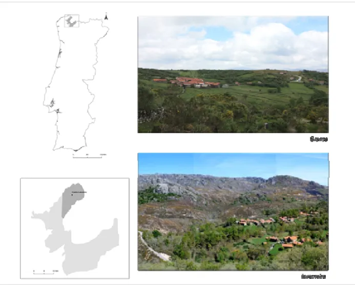
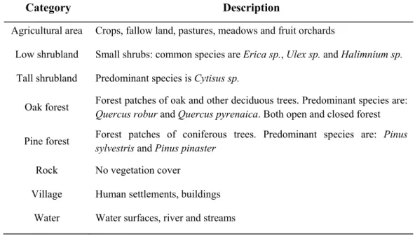
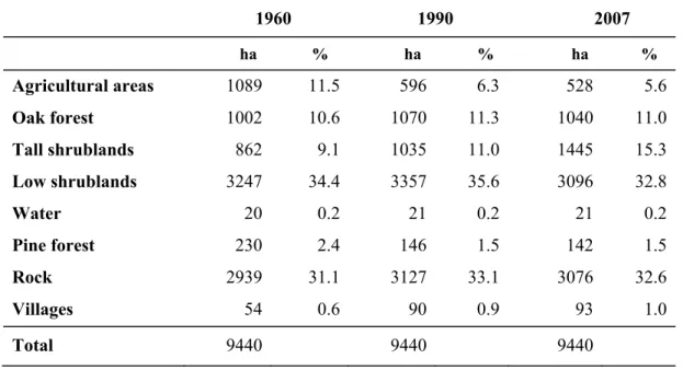
Figure 1. Location of Peneda-Gerês National Park (light grey) and the study area, including Castro
Laboreiro parish (dark grey). On the right, the pictures illustrate brandas (summer villages in the plateau) and inverneiras (winter villages in the valley). // Figura 1. Localização do Parque Nacional da Peneda-Gerês
(cinzento claro) e da área de estudo, incluindo a freguesia de Castro Laboreiro (cinzento escuro). À direita, as fotografias representam as brandas (aldeias de Verão, no planalto) e as inverneiras (aldeias de Inverno, no vale).
Landscape characterization and interpretation Data source and type
We made landscape characterization by photo interpretation. Black and white aerial geo-referenced photographs and color orthophotos were obtained from the Portuguese Geographic Institute (IGEO) taken in 1960 (1:8000), 1990 (1:10000) and 2007 (1:10000). Photo interpretation was made on screen by digitizing polygons (hereafter patches) for each land use or land cover category (Table 1) on a GIS environment (ArcMap 9.3, ESRI 2010). Categories were defined as areas of homogeneous cover characteristics.
Interpretation was made using a regressive updating technique, starting from the more recent photographs (2007) and working backwards in time to the oldest pictures (1960). With this technique we can guarantee that the first time layer is made from the more accurate photographs allowing validation on the field (Bender 2005). This first interpreted land-use layer (2007) was then used as a basis to obtain the layer of 1990 (by adding, modifying or deleting lines in order to reflect changes). The same approach was applied to the layer of 1990, in order to obtain the 1960’s layer. Interpretation of 2007 orthophotos was aided by the 2000 Land Use-Cover Map of the Park and the interpretation of 1990 photographs was aided by 1990 National Land Use-Cover Map (from IGEO). The minimum mapping unit was around 0.1 ha, and the scale of interpretation was 1:5000. In order to assess the quality of the interpretation, 100 points were randomly distributed in the landscape and field validation was performed.
Data analysis
Land cover changes and landscape structure
We assessed land use changes by means of transition matrices and trajectory analysis in order to measure the rate and direction of changes at each time interval. Transition matrices were computed in hectares, per category by overlaying and intersecting two different time layers. Three transition layers 1990, 1990-2007 and 1960-2007) and one trajectory layer (1960-1990-2007) were derived. After each intersection step some slivers were unintentionally produced, as a result of positional errors when digitizing the layers. These slivers were eliminated by merging with neighboring polygons with the largest shared border. The elimination of the slivers had not a significant effect on the values of land use changes.
Table 1. Description of land-use categories defined for landscape interpretation. // Tabela 1. Descrição das
categorias de uso do solo definidas para a foto-interpretação da paisagem.
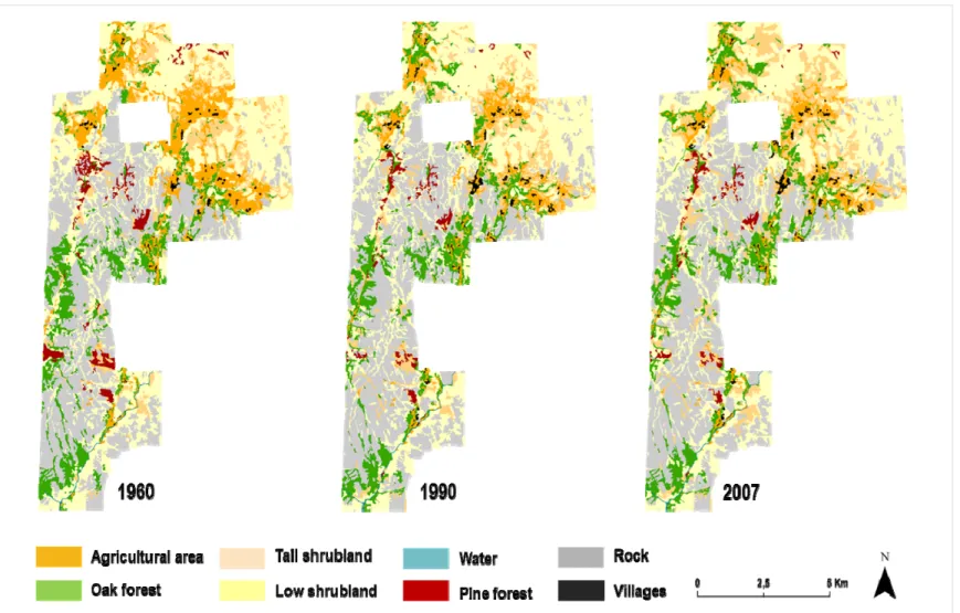
Category Description
Agricultural area Crops, fallow land, pastures, meadows and fruit orchards
Low shrubland Small shrubs: common species are Erica sp., Ulex sp. and Halimnium sp. Tall shrubland Predominant species is Cytisus sp.
Oak forest Forest patches of oak and other deciduous trees. Predominant species are: Quercus robur and Quercus pyrenaica. Both open and closed forest Pine forest Forest patches of coniferous trees. Predominant species are: Pinus
sylvestris and Pinus pinaster Rock No vegetation cover Village Human settlements, buildings
Water Water surfaces, river and streams
As the analysis of land-use change trajectories generates a large amount of possible combinations between different land-use types, and given that not all the trajectories are representative at the landscape level or important from an ecological succession perspective, trajectory analysis in the study area was focus on a subset of data. The subset refers to 4 land-use type categories – the ones assumed to be directly enrolled in the process of natural succession and forest regeneration (i.e. agricultural area, low shrubs, tall shrubs, and oak forest). A diagram of land use trajectories from 1960 to 2007 was built, following the approach of Kӓyhkӧ and Skånes (2006).
In order to quantify landscape structure we derive a set of landscape metrics for each time layer (Baessler and Klotz 2006, Geri et al. 2010). The following landscape metrics were selected: number of patches (NP); mean patch size (MPS); mean shape index (MSI) and landscape shape index (LSI). The metrics NP and MSI can be used as indicators of landscape fragmentation; MSI can be used as an indicator of class shape complexity - MSI measures the average perimeter-to-area ratio for a particular patch type (Pan et al. 2001, McGarigal and Marks 1995). LSI quantifies the amount of edge present in the landscape and can be interpreted as a measure of patch aggregation (as LSI increases, patches become increasingly disaggregated) (McGarigal and Marks 1995). The Fragstats 3.3 ArcGrid module was used to compute landscape metrics (McGarigal and Marks 1995).
Patterns in oak regeneration and abandonment of fields
Environmental attributes of the landscape
We use slope (SLO), elevation (ELE), aspect (ASP) and distance to water (dWAT) as variables representative of abiotic and topographic conditions. The variables distance to the nearest village (dVILL) and distance to the nearest road (dROAD) were selected as proxies for degree of accessibility of the fields. The distance to the nearest oak source (dOAK) was selected as a proxy for seed dispersal and fire (FIRE) as a representation of disturbance regime. The variables ELE, ASP, SLO and dWAT were derived from the Digital Elevation Model (ASTER GDEM) with a 30 m spatial resolution, acquired from the ERSDAC (2009). The layers of each of these variables were further intersected with the transition layer of 1960-2007 and the mean values were extracted for each individual patch, using the patch centroid as the origin. The variable ASP was transformed into a measure of northness = cosine (aspect), where north=0º (Blake and Schuette 2000).
A series of proximity analysis (in GIS environment) were applied in order to derive distance to the nearest village (dVILL), distance to the nearest oak source (dOAK), distance to the nearest road (dROAD), and distance to water (dWAT). The nearest oak source is given by the oak patches that remained unchanged between 1960 and 2007. The centroids of each patch were used as the basis for distance calculations. Data on fire episodes was collected (only available from 1990 onwards in the National Forest Authority) and a map of forest and shrubs loss was built for the period of 1990-2007 and intersected with fire information. Data on burnt areas of oak forest and shrubs were derived from the resulting map.
Regression analysis of transition types and landscape environmental attributes
A series of logistic regressions were performed in order to investigate the relation between both forest regeneration and abandonment of fields and the environmental attributes of the landscape, for the entire study period (1960-2007). Transition type was used as the response variable (1-transition occurred, 0-no transition occurred) and ELE, ASP, SLO, dWAT, dOAK, dROAD, dVILL and FIRE as the predictor variables. Two main different analyses were performed (see Table 2 for the correspondence of environmental attributes used in each case):
(A) focused on oak regeneration (transition from agricultural areas, low shrubs or tall shrubs into oak forest). These analyses were made for the period of 1960-2007, at the landscape level and at brandas & inverneiras level. Given that fire data was only available from 1990 onwards, an independent analysis was performed for the period of 1990-2007, in order to assess if fire had an effect in oak regeneration at the landscape level;
(B) focused on abandonment of fields (transition from in-use into abandoned fields). This analysis was made for the period of 1960-2007, and applied at the landscape and at brandas & inverneiras level.
In brandas & inverneiras analysis, a buffer of 800m diameter was created around each village in order to define the area to be analyzed, and the variable elevation was excluded from the analysis due to the small spatial variability.
Table 2. Details on the predictor variables and scales, for the logistic regression analyses. Predictor
variables are the environmental attributes of the landscape: ELE – elevation; ASP – aspect; SLO – slope; dOAK – distance to the nearest oak source; dWAT – distance to water; dROAD – distance to the nearest road; dVILL – distance to the nearest village. // Tabela 2. Detalhes das escalas e das variáveis explicativas usadas nas análises de regressão logística. As variáveis explicativas correspondem aos atributos ambientais da paisagem: ELE – altitude; ASP – orientação; SLO – declive; dOAK – distância ao carvalhal mais próximo; dWAT – distância à água; dROAD – distância à estrada mais próxima; dVILL – distância à aldeia mais próxima.
Analysis Transition Type Spatial Scale Temporal Scale Predictor variables (A) Oak regen.
Landscape 1960-2007 ELE, ASP, SLO, dOAK, dWAT Bran. & Inver. 1960-2007 ASP, SLO, dOAK, dWAT
Oak regen.
(fire effect) Landscape 1990-2007 FIRE, ELE, ASP, SLO, dOAK, dWAT
(B) Abandonment of fields
Landscape 1960-2007 ELE, ASP, SLO, dROAD, dVILL, dWAT Bran. & Inver. 1960-2007 ASP, SLO, dROAD, dVILL, dWAT
An initial full logistic model with all the predictor variables included, was submitted to a stepwise regression with backward elimination in order to obtain the significant variables. ANOVA’s were applied in order to check if the removal of a variable had a significant effect in the model (p<0.05). When necessary, the variables were log and square-rooted transformed. The interactions between the different variables were also assessed, as well as the linearity of the bivariate relationship between each of the predictor variables and the response variable (Gellrich et al. 2007). For predictor variables that did not exhibit a linear relationship with the response variable we added a quadratic term (Gellrich et al. 2007).
The selection of the most parsimonious models was based on the AIC criteria. The area under the receiver operating characteristics (ROC) curve was selected as a measure of model validation and overall accuracy. The greater the score for the area under the ROC curve, the greater the accuracy of the model in predicting correctly the probability of transition (Fawcett 2006). Prior to logistic regression a univariate Pearson correlation was computed between each pair of the predictor variables to check for possible correlation between the variables (|r| > 0.40) (Peng et al. 2002). Statistical analyses were performed with R software (R Development Core Team 2010).
RESULTS
Land cover changes and landscape structure
The landscape of Castro Laboreiro underwent important transformations during the period of 1960-2007. Landscape composition has been overall dominated by low shrublands and rock (which together represent around 65% of the total landscape). In 1960, agricultural areas represented 11.5% of the total study area and in 2007 that value decline by 52% (Table 3). Tall shrublands had an opposite trend, increasing by 68% their area in the parish (from 9.1% in 1960 to 15.3% in 2007). The amount of area occupied by oak forest increased slightly during the entire study period, from 10.6% in 1960 to 11% in 2007 (with a decline from 1990 to 2007). Pine representation in the total landscape declined from 2.4% to 1.5% and the area occupied by villages doubled during the 47 years period, but represents no more than 1% of the total area (Table 3 and Figure 2).
Table 3. Evolution of land-use categories in the total study area, between 1960 and 2007. // Tabela 3. Evolução das categorias de uso do solo para na área total de estudo, entre 1960 e 2007.
1960 1990 2007 ha % ha % ha % Agricultural areas 1089 11.5 596 6.3 528 5.6 Oak forest 1002 10.6 1070 11.3 1040 11.0 Tall shrublands 862 9.1 1035 11.0 1445 15.3 Low shrublands 3247 34.4 3357 35.6 3096 32.8 Water 20 0.2 21 0.2 21 0.2 Pine forest 230 2.4 146 1.5 142 1.5 Rock 2939 31.1 3127 33.1 3076 32.6 Villages 54 0.6 90 0.9 93 1.0 Total 9440 9440 9440
From the 100 points randomly placed in the landscape, only 87 points were validated (13 points could not be validated due to inaccessibility). The categories agricultural area, pine forest and low shrublands had 100% of accuracy in classification. The categories rock and tall shrubland had an error of 17 and 35%, respectively. Tall shrubland was mostly misclassified
Figure 2. Thematic maps of landscape interpretation, for the years 1960, 1990 and 2007. // Figura 2. Mapas da caracterização da
Most of the changes occurred between 1960 and 1990. During this period, at least 28% of the area occupied by agricultural fields, tall shrublands, oak forest and pine forest changed into another category (see diagonal values in Appendix I-a). During the second period (1990-2007) there was a tendency for stabilization of landscape (more than 84% of the area of each category remained unchanged)(Appendix I-b). However, it was during this period that tall shrubs underwent the greater area expansion. The changes for the overall study period are illustrated in Appendix I-c.
Regarding the rates at which the changes occurred, between 1960 and 1990, the rate of land abandonment was of -1.51 %.yr-1 while during 1990-2007 the decline lessened to -0.67%.yr
-1 (Appendix II). The rate of farmland abandonment is similar to the rate of population decline for
the same study period (Figure 3).
Figure 3. Agricultural area (ha) and number of inhabitants in Castro Laboreiro parish between 1960 and
2007 (INE 1960, 1981, 1993, 2001). Figura 3. Área agrícola (ha) e número de habitantes em Castro Laboreiro
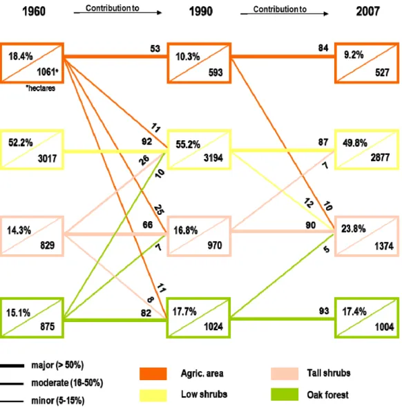
The pathways of change given by the trajectory analysis are represented in Figure 4. Trajectory analysis shows that agricultural land abandoned was partially converted into tall shrubs (25% between 1960-1990 and 10% between 1990-2007), low shrubs and oak forest (11% between 1960-1990, for each case, Figure 4). Low shrubs showed great persistence during the entire study period (92% and 87%), as well as oak forest (82% and 93%). Regarding tall shrubs, 8% were converted into oak patches from 1960 to 1990.
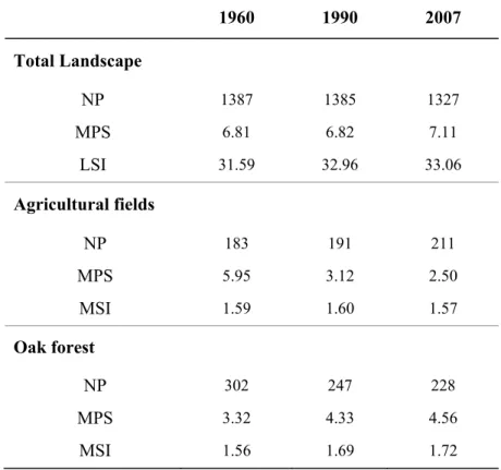
With respect to landscape structure, at the landscape level there was a decline in the total number of patches and a slight increase in the average mean patch size (from 6.81ha to 7.11ha), which indicates a tendency for landscape homogenization. Landscape shape index (LSI) increased from 31.6 in 1990 to 33.1 in 2007 indicating that the patches became more disaggregated due to an increase in the amount of edge (Table 4). The landscape distribution of agricultural areas showed a tendency for fragmentation, given by an increase in the number of patches and a decrease in their mean size. The MSI decreased, indicating a shape simplification of the agricultural patches. Opposite results were found for oak patches, with less but larger patches (NP decreased, and MPS increased), reflecting a tendency for patch aggregation. The MSI for this category increased, pointing to an increment in shape complexity of oak patches (McGarigal and Marks 1995).
Patterns in oak regeneration and abandonment of fields Oak regeneration
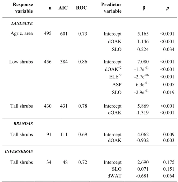
We found no significant correlation between any of the predictor variables; therefore all variables were included in our logistic regression analyses (Table 5). At the landscape level, distance to the nearest oak source (dOAK) is a significant explanatory variable of the probability of oak regeneration (Table 5), either from former agricultural areas (p<0.001), low shrubs (p<0.001) or tall shrubs (p<0.001). The negative value of β-parameter indicates that the patches closer to an oak source are more likely to be converted into oak forest.
Figure 4. Trajectories of land-use change for the subset of categories between 1960 and 2007. Inside each
rectangle is the proportion of the category from the subset, and the corresponding area (in ha). The lines represent the contribution from the former time-layer - i.e. the proportion of each category that was lost into another category or that remained unchanged (horizontal lines). Fractions below 5% are not represented in the diagram. Thickness of the line indicates the degree of change in relation to original land cover. The total area represented by the subset data is of 5781 ha.// Figura 4. Trajectórias das alterações
ocorridas para o subset de categorias de uso do solo, entre 1960 e 2007. Dentro de cada rectângulo está a proporção de cada categoria em relação ao subset, e a área correspondente (em ha). As linhas representam a contribuição do período anterior - i.e. a proporção de cada categoria que se perdeu ou que permaneceu inalterada (linhas horizontais). Proporções inferiores a 5% não estão representadas. A espessura da linha indica o grau de alteração em relação à cobertura inicial. A área total representada pelo subset é de 5781ha.
Table 4. Landscape structure metrics for the total landscape, agricultural fields and oak forest. NP -
number of patches; MPS - Mean patch size; LSI - Landscape Shape Index; MSI - Mean shape index.// Tabela 4.Índices da estrutura da paisagem, para a área total de estudo e para as áreas agrícolas e de carvalhal.NP – número de patches; MPS – Tamanho médio dos patches; LSI – Indice da forma da paisagem; MSI – Índice da forma média dos patches.
1960 1990 2007 Total Landscape NP 1387 1385 1327 MPS 6.81 6.82 7.11 LSI 31.59 32.96 33.06 Agricultural fields NP 183 191 211 MPS 5.95 3.12 2.50 MSI 1.59 1.60 1.57 Oak forest NP 302 247 228 MPS 3.32 4.33 4.56 MSI 1.56 1.69 1.72
In oak regeneration from agricultural fields, the variable slope is also statistically significant (p<0.05), with a positive relation with transition into oak forest (β = 0.224). With respect to the conversion from low shrubs into oak forest, the variables elevation (p<0.001) and slope (p<0.05) were negatively related with the response variable, indicating that patches of low shrubs located at lower elevations and in flatten slopes were more likely to be converted into oak forest (Table 5). The variable aspect (p<0.01) was positively related with the conversion from low shrubs into oak forest. The model had a good accuracy (ROC=0.86), in predicting correctly the probability of transition to oak patches. In oak regeneration from tall shrubs, dOAK was the only statistically significant explanatory variable (p<0.001) kept by the model (Table 5).
Table 5. Logistic regression results for oak regeneration analysis. Backward stepwise regression was
performed for each transition type (response variable) and the environmental attributes of the landscape (predictor variables). The variable dOAK was log transformed and the variables dWAT and SLO were square-root transformed. // Tabela 5. Resultados das regressões logísticas para a análise da regeneração de carvalhal. Uma análise stepwise descendente foi efectuada para os tipos de transição (variável resposta) e os atributos ambientais da paisagem (variáveis explicativas). A variável dOAK sofreu uma transformação logarítmica e as variáveis dWAT e SLO uma transformação √.
The general results of the brandas & inverneiras analysis revealed that proportionally, in brandas there was a higher increase in the oak areas when compared with Inverneiras (+ 55.2 % and +17%, respectively). The logistic regression results for oak regeneration show that for Brandas, dOAK is the only statistically significant predictor variable (p<0.01) with a negative relation with the response variable. In inverneiras, distance to water (p=0.064) and slope (p=0.151) were the only variables that remained in the model, but only with marginal statistical significance (Table 5).
Response
variable n AIC ROC
Predictor
variable β p LANDSCPE
Agric. area 495 601 0.73 Intercept 5.165 <0.001
dOAK -1.146 <0.001
SLO 0.224 0.034
Low shrubs 456 384 0.86 Intercept 7.080 <0.001
dOAK^2 -1.7e-01 <0.001
ELE^2 -2.7e-06 <0.001
ASP 6.3e-01 0.005
SLO -2.9e-01 0.019
Tall shrubs 430 431 0.78 Intercept 5.869 <0.001
dOAK -1.319 <0.001
BRANDAS
Tall shrubs 91 111 0.69 Intercept 4.062 0.009
dOAK -0.932 0.003
INVERNEIRAS
Tall shrubs 34 48 0.72 Intercept 2.690 0.175
SLO 0.071 0.151
The role of fire
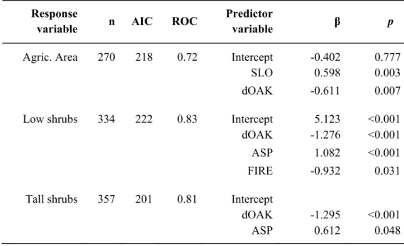
Between 1990 and 2007, a total of 2491 ha of the landscape were affected by fire. Oak forests and low shrubs recorded a negative balance in their total area in the landscape between 1990 and 2007. The data on burnt area for the same period explains around 25% of the area lost by oak forests and 3% of the decline in low shrubs. Additionally, and though not presenting a negative balance between 1990 and 2007, tall shrubs also lost area, 33% of which can be explained by fire. The results for the logistic regression analysis for the fire effect on oak regeneration are illustrated in Table 6.
Table 6. Logistic regression results for the fire effect on oak regeneration at the landscape level, between
1990 and 2007. Backward stepwise regression was performed between each transition type (response variable) and the environmental attributes of the landscape (predictor variables). The variable dOAK and SLO were transformed, using log and square-root transformation, respectively. // Tabela 6. Resultados sobre o efeito do fogo na regeneração de carvalhal ao nível da paisagem, para o período entre 1990 e 2007. Uma análise stepwise descendente foi efectuada entre os tipos de transição (variável resposta) e os atributos ambientais da paisagem (variáveis explicativas). As variáveis dOAK e SLO sofreram transformação logarítmica e raíz-quadrada, respectivamente.
FIRE was a statistically significant variable (p<0.05) only in the transition from low shrubland into oak, showing a negative relation given by the β parameter, indicating that the patches where fire did not occurred, added to a lower distance from an oak source and northern faced (positive β parameter for ASP), are more likely to be converted into oak. The model had a good performance (ROC=83%), in predicting correctly the probability of oak regeneration. The
Response
variable n AIC ROC
Predictor
variable β p
Agric. Area 270 218 0.72 Intercept -0.402 0.777
SLO 0.598 0.003
dOAK -0.611 0.007
Low shrubs 334 222 0.83 Intercept 5.123 <0.001
dOAK -1.276 <0.001
ASP 1.082 <0.001
FIRE -0.932 0.031
Tall shrubs 357 201 0.81 Intercept
dOAK -1.295 <0.001
variable dOAK was again, a statistically significant variable in all transition types. Besides dOAK, the variable ASP (northern faced) was also a statistically significant variable in the transition from shrubs into oak.
Abandonment of fields
Regarding the abandonment of fields at the landscape level, results indicate that elevation and slope are the most statistically significant variables (p<0.0001), together with distance to the nearest village (p<0.05), and all show a positive relation (positive β parameter) with abandonment of fields (Table 7). This means that the patches located in steep slopes, higher elevations and at longer distances from a village are more likely to become abandoned. The model presented an overall accuracy of 65%.
Table 7. Logistic regression results for the abandonment of fields’ analysis. Backward stepwise
regression was performed between each transition type (response variable) and the environmental attributes of the landscape (predictor variables). The variables SLO, dWAT and dROAD were square-root transformed. The variable dVILL was log transformed for the landscape level.// Tabela 7. Resultados das regressões logísticas para a análise de abandono dos campos agrícolas. Uma análise stepwise descendente foi efectuada entre os tipos de transição (variável resposta) e os atributos ambientais da paisagem (variáveis explicativas). As variáveis SLO, dWAT e dROAD sofreram uma transformação logarítmica e a variável dVILL uma transformação √.
Response
variable n AIC ROC
Predictor
variable β p LANDSCAPE
Abnd. fields 941 988 0.65 Intercept -3.890 <0.001
ELE 0.003 <0.001
SLO 0.299 <0.001
dVILL 0.251 0.013
BRANDAS
Abnd. fields 240 259 0.62 Intercept 6.72e-01 0.107
dROAD 1.16e-01 0.009
dVILL^2 -8.27e-06 0.019
INVERNEIRAS
Abnd. fields 94 116 0.63 Intercept 0.158 0.733
The general results for brandas & inverneiras indicate that proportionally there was a higher loss in the area occupied by agricultural fields 47.2%) in brandas than in inverneiras (-29.6%). In brandas, dROAD and dVILL were the only statistically significant variables. The β parameter indicates that the patches far from a road (β = 1.08e01) and near to a village (β = -8.28e-06) are more likely to become abandoned. In inverneiras the only variable that remained in the model was dVILL (p>0.05), but again caution must be taken since it is not statistically significant (Table 7).
DISCUSSION
Land cover changes and landscape structure
The landscape of Castro Laboreiro parish underwent important changes after 1960. The inhabitants of the parish started migrating around the 1950’s, and consequently farmlands became abandoned. The first period of the study, between 1960 and 1990, was characterized by a substantial decrease in agricultural area (-45%), while the second period (1990–2007) was marked by the conversion of the former agricultural fields into shrublands. This pattern of abandonment agrees with a large range of studies on farmland abandonment in other European mountain regions (see a review by MacDonald et al. 2000). For the entire study period (1960-2007), the main changes in the landscape can be summarized as follow: a decrease of 52% in agricultural areas and of 38% in pine forest, and an increase of 68% in tall shrublands and of 4% in oak forest. A great part of the pine forest that existed in the parish in 1960 was planted around the 1940’s as a measure from the afforestation policy implemented by the central government. However, most of the planted pine did not survived, explaining the 38% of decline.
The modest increase in oak forest observed in Castro Laboreiro does not follow the trend of forest regeneration in mountain regions in Europe. This can be explained by two reasons. The first reason relies on the accuracy of landscape interpretation and in a likely underestimation of oak areas. Mature oak patches are easily distinguished in color orthophotos, but the same is not true for young trees. When performing field validation, 35% of the points classified as tall shrubs, where in fact young oak trees, undistinguishable in 2007’ orthophotos. If we assume that 35% of tall shrublands are in fact oak forest in 2007 and in 1960, we then get an increase of 18% in oak forest between 1960 and 2007. This assumption approaches the European trends of forest regeneration in mountain areas (e.g. Conti and Fagarazzi 2004, Lasanta-Martínez et al. 2005, 2001, Tasser et al. 2007). The second reason arises from the initial proportion of oak forest already present in 1960. This initial proportion (10.6%) is much lower when compared to other similar studies, which is reflected in incipient forest regeneration at the landscape level. For instance, in a study on the transformations of a rural landscape in the Eastern Pyrenees (Roura-Pascual et al. 2005), during a 47 years’ period (1953-2000) there was an increase of 19% in the area occupied by forest. This increase was based on an initial value of 33% forest coverage in 1953. Also, in the study of Poyatos et al. 2003, in the Catalan Pre-Pyrenees, from 1957 to 1996 there was an increase of 25% in the area occupied by forest. In this case the initial area of forest
in 1957 was of 39.4%. Other examples can be found in the studies by Tasser et al. (2007) for the Eastern Alps and Lasanta-Martínez et al. (2005) for the Spanish Central Pyrenees.
One of the main findings from trajectory analysis was the tendency for a direct conversion of abandoned fields into tall shrublands, during both the first and second study periods. In the parish, tall shrublands are dominated by Cytisus sp., a species that is traditionally used by the locals to feed the cattle and produce manure. The manure is then used to fertilize the fields, and with time, this process might have created a seed bank of Cytisus sp., promoting the direct conversion once fields were abandoned. This explanation is supported by the work of Eastbrook (1994) on the role of Cytisus sp. in traditional agricultural practices in Portugal. Another finding of the study was a trend for landscape homogenization based on the landscape metrics we used, indicating a reduction in the open areas associated with agricultural fields. These became smaller and more scattered in the landscape as oak patches increased their size, becoming more aggregated. Both are common patterns found in several studies that use landscape metrics to assess changes in landscape structure, as a consequence of farmland abandonment (see for example Geri et al. 2010 and Zomeni et al. 2008).
Patterns in oak regeneration and abandonment of fields
To understand the dynamics of landscape changes, it is necessary to take into account the interplays and relations of these changes with the environmental attributes of the landscape. One of the most obvious results of our analysis on the patterns of oak regeneration, both at the landscape and brandas & inverneiras level, is the negative relationship of oak regeneration with the distance to the nearest oak source (dOAK): the higher the proximity to an oak source, the greater the probability of transition into oak forest. The same pattern was found in the studies by Gellrich et al. (2007) and Tasser et al. (2007). In the later study, the authors found that seed dispersal was one of the most important variables influencing forest regeneration in the Eastern Central Alps. Nevertheless, our variable does not distinguish between oak regeneration as a result of an expansion from the neighboring oak patches, from the effect of dispersers (like jays and squirrels), and given that the distance to an oak source is also related to the type and efficiency of dispersers (Tasser 2007), it would be interesting to develop an approach that incorporates the effect of dispersers as a variable.
The topographic elements slope (SLO) and aspect (ASP) also showed an effect on forest regeneration like found by Carmel et al. (2007). In the transition from agricultural fields into oak patches, the positive relation with slope, might indicate the preferential abandonment of steep fields, allowing regeneration of oak forest to occur first, rather than in flatten terrain. These results are consistent with those found in the study by Gellrich et al. (2007). The authors examined natural forest regrowth on abandoned agricultural fields in the Swiss mountains, relating the patterns of forest regeneration with geophysical and socio-economic variables. They found that forest regrowth was favored in fields with steep or intermediate steepness, and closer to forest edges. Moreover, in our study, fire had a significant effect on oak regeneration only in the transition from low shrubs, and that effect, as expected was negative, meaning that patches where fire did not occur where more likely to evolve into oak forest.
The analysis of abandonment of fields showed that, at the landscape level, agricultural patches that are located at higher elevations, in steep slopes and far from a village, are more prone to be abandoned. Cultivation is easier if accessibility conditions are better (e.g. to allow the use of machinery). Consequently fields near roads, near villages and with flatten topography are expected to be preferably maintained. These findings agree with the work by Sluiter and M. de Jong (2007) who found that agricultural areas located far from villages and far from roads where preferably abandoned. It would have been interesting to assess if the area of each agricultural field had an effect on the probability of abandonment, as well as if there was an aggregated or scattered pattern in the abandonment (Silber and Wytrzens 2006). Though, the inexistence of cadastral maps for the study area made it impossible to sort out each field and to test area as a variable.
Life on Castro Laboreiro was structured around pastoral activities. The inhabitants of the parish would spend around 9 months of the year in brandas, where the majority of their social and economic activities took place. The terrain is flat and with the improvement of living conditions (house heating, road accessibility…) people decided to remain permanently in brandas (Geraldes 1996). Therefore, nowadays a great part of the inverneiras is abandoned. As so, it would be expected a higher proportion of abandoned agricultural area in inverneiras rather than in brandas, but results show the opposite: proportionally there was more abandonment and oak regeneration in brandas. This can be explained by some fields being still kept in inverneiras. The lower altitude at which inverneiras are located and soil characteristics allow the cultivation
of different crops, from the ones cultivated in the plateau (e.g. fruit trees, gardens…)(Aguiar et al. 2010). Additionally, the total agricultural area in brandas was larger than in inverneiras demanding more effort for cultivation. In what regards oak regeneration, the higher proportion found in brandas might be again related with the initial proportion of oak forest already present in 1960 (which was much lower in brandas than in inverneiras). Finally, the analysis at Brandas & Inverneiras level detaches the importance of scale in uncovering patterns that were not visible at the landscape level, and how they can affect the type of explanation given to the results.
Although out of the scope of this study, grazing pressure is also an important variable to consider when analyzing and predicting the dynamics of the landscape changes in agro-pastoral systems. In particular, in Castro Laboreiro, a decline in the pastoral activities came along with farmland abandonment, where the number of goats and sheep in the parish declined by 89% from 1955 to 1989 (INE 1955, 1972, Geraldes 1996). In the studies by Chauchard et al. (2007) and Carmel and Kadmon (1999) it is demonstrated that vegetation regeneration is controlled by a threshold of grazing pressure for what this decrease in the livestock pressure might contribute to understand the expansion of shrublands in the study area.
Uncertainties and limitations
The methodology applied in this study had some limitations that need to be addressed. The differences in the quality of the orthophotos and aerial-photographs can lead to two types of errors: positional errors (when the misplacement of boundaries occurs as a result of the different ortho-rectification of the pictures) and classification errors (as a result of misclassification of categories)(Kienast 1993). It is then important to have an accurate assessment and quantification of the error associated with the interpretation, and to integrate the error in the results. Also, the influence of spatial autocorrelation on the results of logistic regression cannot be excluded.
FINAL REMARKS
The dynamics of mountain farmland abandonment and its reciprocal feedbacks between ecological, economic and social dynamics has been recently studied by Figueiredo and Pereira (submitted). In their work, the authors demonstrate the trends of group migration when economic return obtained in farmlands cannot match the utility obtained in the city. Furthermore, they demonstrate that after migrating to the city the return to farmland is very difficult, since the area is progressively replaced by forest. Looking at Castro Laboreiro population’s trend in the last 50 years, it is likely that the tendency of farmland abandonment will continue, and likewise, natural regeneration of former agricultural areas into shrubland and forest will continue as well.
As mentioned previously, oak forests are priority habitats that play an important role in providing a large range of ecosystem services. Oak forests have slow growth rates and natural regeneration will depend on the proximity of seed sources and on the presence of seed dispersers. It is reasonable to think that the great expansion of tall shrublands in Castro Laboreiro parish, will contribute to the accumulation of combustible biomass, and therefore to increase the risk of fire events, that depending on the frequency and intensity, will affect the regeneration of native oak forest (Moreira et al. 2001, Proença 2009). Given that only 5% of native deciduous oak forest remains in Portugal (AFN 2010), adequate management options should be developed as a priority.
Several management options can be taken to address farmland abandonment, and the strategies will depend on the goals of what we want to conserve and preserve. Two main strategies are worth mentioning: (i) preserve the cultural landscapes and prevent abandonment, or (ii) promote forest regeneration (Pereira et al 2005, Chauchard et al. 2007). The first approach implies pay to maintain agricultural areas, based on economic incentives and subsidies like the Integrated Territorial Interventions (ITI) from PRODER program. The second focus on promoting natural regeneration of vegetation, using ecosystem services as a tool for management (Queiroz 2010). For both strategies, the management of mountain agricultural ecosystems requires an understanding of past uses in order to predict future changes and account for adequate sustainable measures.
ACKNOWLEDGMENTS
I am especially thankful to my supervisor and friend Henrique Miguel Pereira (also known as “Chefão” or “Chefinho” - depending on the context!) for his guidance, patience, and for all the opportunities given during these last two years. I have learnt a lot!
I am also very grateful to all of my lab friends and colleagues for their constant support, valuable comments, motivation, and for their therapeutic jokes in the numerous ArcMaps’ crashing crisis. Thank you all, a lot!
Finally I wish to thank to all of my friends and family. You rock!
This study was supported by a fellowship of the Project PTDC/AMB/73901/2006, “ABAFOBIO - Abandono agrícola, fogo e o futuro da biodiversidade”. http://theoeco.fc.ul.pt/projects/index.html.
REFERENCES
Aguiar C., Rodrigues O., Azevedo J., Domingos T. (2010) Montanha. Capítulo 9. in Pereira H. M., Domingos T., Vicente L., Proença V. (2010). Ecossistemas e Bem-Estar Humano. Avaliação para Portugal do Millenium Ecosystem Assessment. Escolar Editora.
Alves A. L., Carvalho N. S., Silveira S. C. B., Marques J. P., Costa Z., Horta A. L. L. (2003) O abandono da actividade agricola. Ministerio da Agricultura do Desenvolvimento Rural e das Pescas, Grupo de trabalho agro-ambiental, Lisboa.
Baessler C., Klotz S. (2006) Effects of changes in agricultural land-use on landscape structure and arable weed vegetation over the last 50 years. Agriculture, Ecosystems and Environment. 115:43-50. Barreto A. (2002) Mudança social em Portugal: 1960-2000. Instituto de Ciências Sociais. Universidade
de Lisboa.
Bender O., Boehmer H. J., Jens D., Schumacher K. P. (2005) Using GIS to analyze long-term cultural landscape change in Southern Germany. Landscape and Urban Planning. 70:111-125.
Bernaldez F. G. (1991) Ecological consequences of the abandonment of traditional land use systems in central Spain. CIHEAM. Options Méditerranéennes - Série Séminaires 15:23-29.
Blake J. G., Schuette B. (2000) Restoration of an oak forest in east-central Missouri: early effects of prescribed burning on woody vegetation. Forest Ecology and Management 139: 109-126.
Blondel J. (2006) The ‘Design’ of Mediterranean Landscapes: A Millennial Story of Humans and
Ecological Systems during the Historic Period. Human Ecology 34:713–729.
Brown V. K. (1991) Early successional changes after land abandonment: the need for research. CIHEAM – Óptions Mediterraneennes. Série Séminaires 15: 97-101.
Bürgi M., Hersperger A. M., Schneeberger N. (2004) Driving forces of landscape change – current and new directions. Landscape Ecology 19: 857–868.
Carmel Y., Kadmon R. (1999) Effects of grazing and topography on long-term vegetation changes in a Mediterranean ecosystem in Israel. Plant Ecology. 145: 243-254.
Chauchard S., Carcaillet C. Guibal F. (2007) Patterns of land-use abandonment control tree-recruitment and forest dynamics in Mediterranean Mountains. Ecosystems. 10: 936-948.
Conti G., Fagarazzi L. (2004) Sustainable mountain development and the key-issue of abandonment of marginal rural areas. Planum: The European Journal of Planning X 1-19.
Conti G., Fagarazzi L. (2005) Forest expansion in mountain ecosystems: "environmentalist's dream" or societal nightmare? Driving forces, aspects and impacts of one of the main 20th Century's environmental, territorial and landscape transformations in Italy. Planum - The European Journal of Planning XI. 1-20.
Cramer V. A., Hobbs R. J., Standish R. J. (2007) What’s new about old fields? Land abandonment and ecosystem assembly. Trends in Ecology and Evolution 23(2).
Eastbrook G. F. (1994) Neither wild or planted: Esential role of Giesta (Cytisus, Fabaceae) in traditional agriculture of Beira Alta, Portugal. Economic Botany. 60(4):307-320.
ERSDAC - Earth Remote Sensing Data Analysis Center (2009). ASTER GDEM. Available at http://www.gdem.aster.ersdac.or.jp/index.jsp.
Farina A. (1991) Recent changes of the mosaic patterns in montane landscape (North Italy) and consequences on vertebrate fauna. Baudry, J. and Bunce, R. G. H. (eds.). Land abandonment and its role in conservation. CIHEAM. Options Méditerranéennes. Série A 75: 121-134.
Farina A. (2007) Principles and Methods in Landscape Ecology: Towards a science of landscape. Springer. Landscape Series.
EEA – European Environmental Agency (2010) Mountain ecosystems. 10 Messages for 2010. Office for Official Publications of the European Communities.
ESRI - Environmental Systems Resource Institute (2010) ArcMap 9.3. ESRI, Redlands, California. EU – Directorate-General for agriculture and rural development (2009) New Insights into Mountain
Farming in the European Union. Commission staff working document.
Fawcett T. (2006) An introduction to ROC analysis. Pattern Recognition Letters. 26:861-874. Figueiredo J., Pereira H. (submitted) Socio-Ecological Model of Farmland Abandonment.
Graça L. (1996) Regadios tradicionais nas montanhas do norte de Portugal (Serra da Peneda - um caso exemplar). Arroyo Agudo P. and Martínez Gil F.J., Editors. El agua a debate desde la universidad; hacia una nueva cultura del agua. Institución Fernando el Católico, Zaragoza, Spain.
Gellrich M., Baur P., Zimmermann N. E. (2007) Natural forest regrowth as a proxy variable for agricultural land abandonment in the Swiss mountains: a spatial statistical model based on geophysical and socio-economic variables. Environmental Modeling and Assessment. 12: 269-278.
Geraldes A. D. (1996) Brandas e Inverneiras. Particularidades do sistema agro-pastoril castrejo. Cadernos Juríz Xurés. Instituto da Conservação da Natureza e Parque Nacional da Peneda Gerês.