www.the-cryosphere.net/10/459/2016/ doi:10.5194/tc-10-459-2016
© Author(s) 2016. CC Attribution 3.0 License.
Brief Communication: Upper-air relaxation in RACMO2
significantly improves modelled interannual surface mass
balance variability in Antarctica
Willem Jan van de Berg1and Brooke Medley2
1IMAU, Utrecht University, Utrecht, The Netherlands 2NASA-GSFC, Greenbelt, Maryland, USA
Correspondence to:Willem Jan van de Berg ([email protected])
Received: 31 July 2015 – Published in The Cryosphere Discuss.: 21 September 2015 Revised: 5 January 2016 – Accepted: 20 January 2016 – Published: 1 March 2016
Abstract. The Regional Atmospheric Climate Model (RACMO2) has been a powerful tool for improving surface mass balance (SMB) estimates from GCMs or reanalyses. However, new yearly SMB observations for West Antarc-tica show that the modelled interannual variability in SMB is poorly simulated by RACMO2, in contrast to ERA-Interim, which resolves this variability well. In an attempt to remedy RACMO2 performance, we included additional upper-air re-laxation (UAR) in RACMO2. With UAR, the correlation to observations is similar for RACMO2 and ERA-Interim. The spatial SMB patterns and ice-sheet-integrated SMB modelled using UAR remain very similar to the estimates of RACMO2 without UAR. We only observe an upstream smoothing of precipitation in regions with very steep topography like the Antarctic Peninsula. We conclude that UAR is a useful im-provement for regional climate model simulations, although results in regions with steep topography should be treated with care.
1 Introduction
With an annual mass turnover equivalent to a 6 mm change in global sea level, the Antarctic Ice Sheet (AIS) plays an important role in sea-level change. The surface mass balance (SMB) and ice discharge determine the net mass change of the AIS. Recent satellite mass budget studies, e.g. Shepherd et al. (2012) and Velicogna et al. (2014), show a large tempo-ral variability in the AIS mass balance acting on monthly and decadal timescales. Although ice discharge can vary strongly
on multiyear timescales, the SMB variability is responsible for most of the interannual variability in ice-sheet mass bal-ance. Since AIS-integrated SMB can neither be measured remotely nor derived from in situ observations, the SMB and its variability must be derived from atmospheric mod-elling. Evaluation of the mean modelled SMB fields is possi-ble (Favier et al., 2013; Van Wessem et al., 2014a), but until recently a direct evaluation of annual SMB has been impos-sible in the absence of suitable observations. The newly de-veloped technique of combining airborne radar with ice core data provides annual SMB estimates on the scale of a glacier catchment (Medley et al., 2013, 2014). These data provide new opportunities for evaluation of modelled SMB evalu-ation, specifically over the Thwaites Glacier catchment in West Antarctica.
Therefore, we discuss whether relaxation to large-scale forc-ing fields (nudgforc-ing) is beneficial. This relaxation can be im-plemented by using spectral and indiscriminate nudging. In the case of indiscriminate nudging, model fields are adjusted to the large-scale forcing fields without regard to any spa-tial scales and structures in the modelled deviations. As a re-sult, modelled small-scale patterns are partially suppressed because these patterns are absent in the coarser-resolution forcing fields. Relaxation with spectral nudging circumvents smoothing of the model state because relaxation is applied in the spectral space, which allows for adjustment of only the longer wavelengths to the large-scale forcing fields. Spectral nudging is thus potentially better than indiscriminate nudg-ing, but it is computationally more expensive. Although ap-plied at different geographical locations and under different meteorological conditions, several studies (e.g. Pohl and Cré-tat, 2014; Omrani et al., 2015) have shown that relaxation improves the representation of the surface climate and pre-cipitation fields. These studies show that the wind and tem-perature fields are the most important fields to constrain by nudging and that spectral and indiscriminate nudging both improve the representation of the modelled fields.
In this study, we applied upper-air relaxation (UAR), which is indiscriminate nudging applied to the upper part of the atmosphere only. Indiscriminate nudging is justifiable be-cause the upper atmosphere only is gently stirred towards the large-scale forcing fields. In this manner, UAR aims to retain not only the improved spatial patterns provided by a RCM but also the resolved interannual variability of ERA-Interim.
2 Model, methods and observations
2.1 RACMO2
RACMO2 has been used for over a decade to estimate the climate and SMB of Antarctica. RACMO consists of the dynamics of the RCM HIRLAM (High-Resolution Limited-Area Model), the physics package of the ECMWF IFS (Eu-ropean Centre for Medium-Range Weather Forecasts Inte-grated Forecast Systems) and a multilayer snow model in-cluding grain-size-dependent albedo and snow drift. Here, we use RACMO2 version 2.3, which has been described and evaluated in detail for Antarctica by Van Wessem et al. (2014a, b). We compare the simulation presented by Van Wessem et al. (2014a) with ERA-Interim (Dee et al., 2011) and an additional simulation using UAR. Both RACMO2 simulations employ an identical domain and code except for the UAR, and both were driven by ERA-Interim and run from 1979 to 2013. The simulation domain has a res-olution of 27 km, utilizes 40 vertical levels, and extends well outside Antarctica.
2.2 Upper-air relaxation (UAR)
The default version of RACMO2 is adjusted only at its lateral boundaries to weather fields from the driving global model. The interior of the domain is allowed to evolve freely; hence, no nudging is applied to the weather over Antarctica. This freedom is reduced if indiscriminate UAR is applied. In that case, the upper part of the modelled atmosphere is weakly relaxed to the ERA-Interim fields.
This relaxation is implemented in the following manner and is only applied on temperature and wind fields. Humid-ity fields are not relaxed because that would lead to undesired distortions to the modelled clouds and precipitation fluxes, as already observed in the lateral boundary relaxation zones. The relaxation uses the scaled, terrain-following σ coordi-nate which ranges from 0 (zero air pressure) to 1 (at the earth surface). At every time step, a model value (8) at location (x= {x, y, σ}) is adjusted to the driving fields using
8(x)=
1−λτλσ(σ )
8(x)R+λτλσ(σ )8(x)B, (1) where 8(x)R and 8(x)B are the specific values from RACMO2 and the large-scale forcing, respectively, valid for that location and time step. Ifxis located in the boundary re-laxation zone, the boundary rere-laxation is applied additively on Eq. (1).
A relaxation timescale (τ) of 6 h is applied, so for a model time step (tR) of 600 s,λτ, defined as
λτ=1− 1 exp(tR/τ )
,
is 0.027. The vertical relaxation coefficientλσ(σ )is defined with
σ≤0.6: λσ(σ )=
1+cos(σ π/0.6)2
σ≥0.6: λσ(σ )=0.
(2)
Figure 1 shows the values ofσ andλσ as a function of the pressure and elevation for a site at sea level, 2000 m a.s.l, and 4000 m a.s.l. This function allows a gradual stronger re-laxation with elevation without sharp gradients. Using the terrain-following coordinate ensures that the near-surface fields are never relaxed to the driving fields.
2.3 Radar observations in West Antarctica
0
200
400
600
800
1000
Pressure [hPa]
0.00 0.25 0.50 0.75 1.00 0 2 4 6 8 10
Elevation [km]
0.00 0.25 0.50 0.75 1.00 (a) (b)
Figure 1.λσ(σ )(solid lines) andσ(dashed lines) as a function of
(a)pressure and(b)elevation for a location at 0 (black lines), 2000 (red lines) and 4000 (green lines) m a.s.l., respectively.
Figure 2.Map of the study area, including catchment delineation (white line), elevation contours (black lines), radar-derived SMB and the location of the RACMO2 grid points used for compari-son (black dots). The background image is the MODIS Mosaic of Antarctica (Scambos et al., 2007).
3 Results
3.1 Evaluation of mean SMB and climate
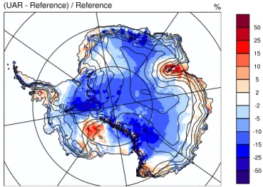
First, the mean 1979–2013 SMB modelled by RACMO2 in-cluding UAR is compared to the reference model version. Figure 3 shows that large-scale SMB patterns are largely un-changed; the differences are typically 10 % of the reference value. Integrated over the grounded ice sheet, the mean an-nual SMB decreases by 80 Gt a−1(4 %) to 1979 Gt a−1. Some areas along the coast receive more mass, but in general pre-cipitation and subsequently SMB decrease. This decrease is related to a small increase of upper-air temperature without an equivalent increase of absolute humidity. At the 500 hPa level, temperatures increase above Antarctica by 0.2 to 0.6 K
Figure 3.Difference in SMB (%) between the UAR and refer-ence RACMO2 simulation for 1979–2013. Grid points with neg-ative SMB in the reference simulation are masked grey.
Figure 4. Observed and modelled integrated annual SMB for Thwaites Glacier catchment, West Antarctica (Fig. 2).
(not shown), while relative humidities decrease by 0 to 2 %. All in all, the difference in the modelled mean climate be-tween the reference and UAR runs is very limited. For exam-ple, mean surface pressures and 2 m temperatures differ only at max 0.7 hPa and 0.6 K, respectively.
3.2 Interannual variability
Table 1.Statistics of modelled SMB for Thwaites Glacier catch-ment, West Antarctica. The mean 1980–2009 SMB derived by snow radar is 457 mm w.e.a−1.
Model simulation Correlation (r) RMSD Bias
( ) (mm w.e.a−1) ERA-Interim 0.93 78 −75 Reference run 0.69 48 −17
UAR run 0.91 43 −35
the mean SMB: RACMO2 is on average less than 2 % drier than observed, leading to a lower root mean square deviation (RMSD). However, much of the representation of the inter-annual variability is lost: the range is comparable, but the cor-relation (r=0.69) has deteriorated. A closer inspection of Fig. 4 shows that model deviations have an episodic nature. For example, the reference run captures the annual SMB well for the period 1985–1991 but deviates strongly for the sub-sequent 3 years. Hence, lateral boundary conditions alone do not provide enough constraints for RACMO2 to reproduce day-to-day weather patterns for some years, but for some years they do. This intermittent model drift is removed in the UAR simulation, which combines the best of both the ref-erence run and ERA-Interim. The mean SMB remains well modelled although the dry bias has increased to 5.5 %. This new simulation, however, reproduces 83 % (r=0.91) of the observed variability, a similar correlation with observations to the ERA-Interim, and has the lowest RMSD.
3.3 Regional patterns
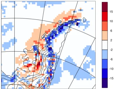
Since ERA-Interim has a native resolution of 0.75◦, UAR dampens small-scale upper-air structures in the RCM. Mesoscale topographic features like the Antarctic Peninsula (AP) are much better resolved in RACMO2 than in ERA-Interim. As a result, for the ERA-Interim fields that are fed into RACMO2, the topographic effect on the circulation in the free atmosphere extends over a much larger area than RACMO2, and the maximum elevation of the mountain ridge is reduced. UAR thus introduces topographic effects at loca-tions where they are not modelled by RACMO2 and fewer topographic effects at the mountain ridge. These artefacts af-fect the precipitation fields modelled on, for example, the AP as shown in Fig. 5. In the adjusted simulation, orographic precipitation is modelled for a much wider area than the AP alone, leading to a decrease of precipitation on the mountain range itself. Although temperature and humidity fields also show small-scale disturbances around the AP, the upper-air wind field is the driving component. Prescribed orographic divergence of the upper-air flow enhances upward motion west of the AP, while on the spine of the AP, UAR reduces the orographically driven vertical motion. An additional test, in which UAR was applied on the wind fields only, shows
Figure 5.Relative difference (%) in precipitation between the UAR simulation and the reference RACMO2 simulation over the Antarc-tic Peninsula.
a similar dispersion of precipitation to the normal UAR sim-ulation. A second test, in which only the stratosphere was constrained, i.e. relaxation forσ ≤0.25 (Eq. 2), showed no improvement of the patterns over the AP, while the corre-lation of modelled SMB with snow radar data for Thwaites Glacier basin clearly deteriorated. We, therefore, conclude that the topographic convergence and divergence of wind fields as prescribed by ERA-Interim affect the precipitation fields over the AP. The limited amount of SMB observations and the high spatial variability of SMB across the AP in-hibit evaluation of the model results. Nevertheless, we assess that this dispersion of precipitation is likely a deterioration of the precipitation fields, since in general RACMO2 has a bet-ter representation of spatial precipitation patbet-terns than ERA-Interim.
4 Discussion and conclusions
spectral nudging, which only adjusts the larger spatial scales in weather patterns, might be a better approach. We believe that these conclusions, although not demonstrated with runs using other reanalyses or GCM boundaries, are general valid for using UAR.
Acknowledgements. The authors would like to thank Xavier Fettweis for kindly providing code examples and the ECMWF and KNMI for the use of their supercomputing facilities. B. Medley was supported by an appointment to the NASA Postdoctoral Program at the Goddard Space Flight Center, administered by Oak Ridge Associated Universities through a contract with NASA. We also acknowledge the generous contribution of faculty, staff and students at CReSIS in collecting and processing the radar data. Most of the radar data used in this work were acquired by NASA’s Operation IceBridge Project.
Edited by: G. H. Gudmundsson
References
Dee, D. P., Uppala, S. M., Simmons, A. J., Berrisford, P., Poli, P., Kobayashi, S., Andrae, U., Balmaseda, M. A., Balsamo, G., Bauer, P., Bechtold, P., Beljaars, A. C. M., van de Berg, L., Bid-lot, J., Bormann, N., Delsol, C., Dragani, R., Fuentes, M., Geer, A. J., Haimberger, L., Healy, S. B., Hersbach, H., Hólm, E. V., Isaksen, L., Kållberg, P., Köhler, M., Matricardi, M., McNally, A. P., Monge-Sanz, B. M., Morcrette, J.-J., Park, B.-K., Peubey, C., de Rosnay, P., Tavolato, C., Thépaut, J.-N., and Vitart, F.: The ERA-Interim reanalysis: configuration and performance of the data assimilation system, Q. J. Roy. Meteor. Soc., 137, 553–597, 2011.
Favier, V., Agosta, C., Parouty, S., Durand, G., Delaygue, G., Gal-lée, H., Drouet, A.-S., Trouvilliez, A., and Krinner, G.: An up-dated and quality controlled surface mass balance dataset for Antarctica, The Cryosphere, 7, 583–597, doi:10.5194/tc-7-583-2013, 2013.
Lenaerts, J. T. M., van den Broeke, M. R., Déry, S. J., van Mei-jgaard, E., van de Berg, W. J., Palm, S. P., and Rodrigo, J. S.: Modeling drifting snow in Antarctica with a regional climate model: 1. Methods and model evaluation, J. Geophys. Res., 117, D05108, doi:10.1029/2011JD016145, 2012.
Medley, B., Joughin, I., Das, S. B., Steig, E. J., Conway, H., Gogi-neni, S., Criscitiello, A. S., McConnell, J. R., Smith, B. E., van den Broeke, M. R., Lenaerts, J. T. M., Bromwich, D. H., and Nicolas, J. P.: Airborne-radar and ice-core observations of annual snow accumulation over Thwaites Glacier, West Antarc-tica confirm the spatiotemporal variability of global and regional atmospheric models, Geophys. Res. Lett., 40, 3649–3654, 2013.
Medley, B., Joughin, I., Smith, B. E., Das, S. B., Steig, E. J., Conway, H., Gogineni, S., Lewis, C., Criscitiello, A. S., Mc-Connell, J. R., van den Broeke, M. R., Lenaerts, J. T. M., Bromwich, D. H., Nicolas, J. P., and Leuschen, C.: Constrain-ing the recent mass balance of Pine Island and Thwaites glaciers, West Antarctica, with airborne observations of snow accumu-lation, The Cryosphere, 8, 1375–1392, doi:10.5194/tc-8-1375-2014, 2014.
Omrani, H., Drobinski, P., and Dubos, T.: Using nudging to im-prove global-regional dynamic consistency in limited-area cli-mate modeling: what should we nudge?, Clim. Dynam., 44, 1627–1644, doi:10.1007/s00382-014-2453-5, 2015.
Pohl, B. and Crétat, J.: On the use of nudging techniques for regional climate modeling: application for tropical convection, Clim. Dynam., 43, 1693–1714, doi:10.1007/s00382-013-1994-3, 2014.
Scambos, T. A., Haran, T., Fahnestock, M., Bohlander, J., and Painter, T.: MODIS-based Mosaic of Antarctica (MOA) data sets: continent-wide surface morphology and snow grain size, Remote Sens. Environ., 111, 242–257, 2007.
Shepherd, A., Ivins, E., Geruo, A., et al.: A reconciled estimate of ice-sheet mass balance, Science, 338, 1183–1189, 2012. Van de Berg, W. J., van den Broeke, M. R., Reijmer, C. H.,
and van Meijgaard, E.: Reassessment of the Antarctic sur-face mass balance using calibrated output of a regional at-mospheric climate model, J. Geophys. Res., 111, D11104, doi:10.1029/2005JD006495, 2006.
Van Wessem, J. M., Reijmer, C. H., Morlighem, M., Mouginot, J., Rignot, E., Medley, B., Joughin, I., Wouters, B., Depoorter, M. A., Bamber, J. L., Lenaerts, J. T. M., van de Berg, W. J., van den Broeke, M. R., and van Meijgaard, E.: Improved rep-resentation of East Antarctic surface mass balance in a regional atmospheric climate model, J. Glaciol., 60, 761–770, 2014a. Van Wessem, J. M., Reijmer, C. H., Lenaerts, J. T. M., van de
Berg, W. J., van den Broeke, M. R., and van Meijgaard, E.: Up-dated cloud physics in a regional atmospheric climate model im-proves the modelled surface energy balance of Antarctica, The Cryosphere, 8, 125–135, doi:10.5194/tc-8-125-2014, 2014b. Velicogna, I., Sutterley, T. C., and van den Broeke, M. R.: Regional