GEOGRAPHIA
NAPOCENSIS
AN.
VII,
nr. 2/2013
geographianapocensis.acad-cluj.ro
IDENTIFICATION OF LANDSLIDES SUSCEPTIBILITY IN THE
DOBRIC CATCHMENT AREA USING THE FREQUENCY RATE
MODEL
ROXANAV IDEAN1,GHEORGHE HOGNOGI
Abstract: - The landslides susceptibility of the Dobric catchment area (Ilişua river). The territorial geomorfological investigation focuses mainly on the analysis of the present situation, as context of future events occurrence. The previous evolutionary context is secondary in place due also to the particular attention it has received so far. The significance of the knowledge regarding the present events and their evolution is explicit in the attempt to mitigate their impact on the built area and on the resources. The identification of areas characterized by maximum susceptibility in the landslides occurrence is absolutely necessary. The method which makes the identification of these areas possible is none other than the method considering the conditional factors, as well as the spatial distribution of the events that have already occurred. In this regard, the use of the frequency rate model is considered to be ideal.
Keywords: landslides, susceptibility, GIS, Dobric, frequency rate
1. Introduction
Dobric is a significant right-side tributary of the Ilişua river in the lower basin and it drains a 39.9 km² area in the East of the Ciceului Hills (Someşului Mare Hills). Due to paleo-geographical evolution, this catchment area includes sediment deposits characteristic to the Miocene (Helvetian, Tortonian) and Holocene epochs. While the latter are presented only in the confluence area with the Ilisua
River, composed of sands and gravels occuring in meadows and lower terraces, the Miocene prevails in the lithological characterisation of the studied catchment area. The Tortonian is relevant in the South-East and punctually in the West, composed of the marly clays interbedded with sandtones, tuffs and gravels, while the Helvetian is present by marly clays with conglomeratic seams which give a dominant note to the study area.
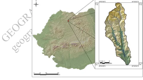
Fig. 1. Location of the Dobric catchment area within national borders
1
GEOGRAPHIA
NAPOCENSIS
AN.
VII,
nr. 2/2013
geographianapocensis.acad-cluj.ro
Within this lythological context, a monoclinal structural relief was developed and its features are very relevant (Cocean. Danciu, 2007) One may recomposed a cuesta in the central part intensely fragmented by the Poieni and Dobricel Valleys together with their tributaries, which come to penetrate the edge of the anticline, becoming consequtive valleys with a North-South flow direction, as the initial structural regime was a cuest back regime.
The weight of the elevation intervals reveals us an area of low hills, a little over 24% of the territory is below 400 m (the meadows and depression areas - min. elevation 269 m), 55.6% is between 400 – 600 m, 19.3% between 600 – 800 m, while elevations higher than 800 m (0.3%) are to be met only in the North-West and in the North (850 m M gura Breaza).
One can notice two tectonic-errosion origine depressions, Ciceu-Poieni and Dobricel which fit in synclinal directed West-East: Spermezeu, Dumbr veni, Zagra, Runcu Salvei (Hognogi et al., 2012).
The importance of the relief in the dynamics and evolution of slopes is materialized by the morphometric parameters, where one can notice: the slopes, the slopes display direction, density of fragmentation and its depth. The first morphometric parameter presents values ranging in the 0-56.9º interval. The 7-15º and 15-35º intervals prevail, occupying more than 82% of the territory. The slopes over 35 º are characteristic only to less than 0.7% of the area (sliding plane) while the values lower than 7 º prevail in the meadow or depression area (6%).
The analysis of surfaces display direction reveals a predominant weight (62.88%) of the sunny areas (the North and North-West of the catchment area, the right slope of Dobricel), the shadow areas (37.22%) occur left from Dobric and the two main tributarries (Dobricel and Ciceului Valley).
The value of fragmentation density slightly exceeds the 6 km/sqkm value. The maximum values occur in North-West, but higher values occur in the North-East and at the confluence of Dobricel with Poieni Valley.
The depth of fragmentation with values ranging between 0-97 m/ha, the 20-35 m/ha prevailing interval characterizes more than 44% while the values higher than 35 m/ha characterize the maximum elevation areas (North and Centre).
The average annual rainfalls increase altitudinally from 670 mm in the meadow area to 875 mm in the North and North-West. The rainfall regime is relevant for our study, and this is the reason why one should mention the high vulnerability to heavy rainfalls of the North-Western part of the Transylvanian Depression (Croitoru Adina-Eliza, 2006 cited by Hognogi et al., 2012).
The land use analysis reveals a 33% cover of the forest area, a 51% cover of shrubs and grassland areas, while the arable area represents a little bit over 15%. The rest of land use categories are negligible in weight.
2. Methodology
The current study starts from the premise that the landslide susceptibility of the slopes might be best determined based on the frequency rate model. This model is reccommended not only by its wide use, but also by the basic principle and this is the “possibility to foresee the future occurrence areas of the landslides based on the scientific analysis of the factors leading to their activation (Lee, Pradhan, 2007, cita i de Arghiuş, Corina, 2010), considering the fact that “future phenomna will occur under the same conditions as the previous or present ones” (Guzetti et al., 1999, cited by Arghius, Corina, 2010).
The model implies the analysis of the relation between the spatial distribution of landslides and the control factors, in order to reveal the correlation between the location of landslides and the parameters controlling their occurrence and evolution. The correlation is identified by relatng the percentage of the area covered by landslides for each analyzed factor whose result is the frequnecy rate.
GEOGRAPHIA
NAPOCENSIS
AN.
VII,
nr. 2/2013
geographianapocensis.acad-cluj.ro
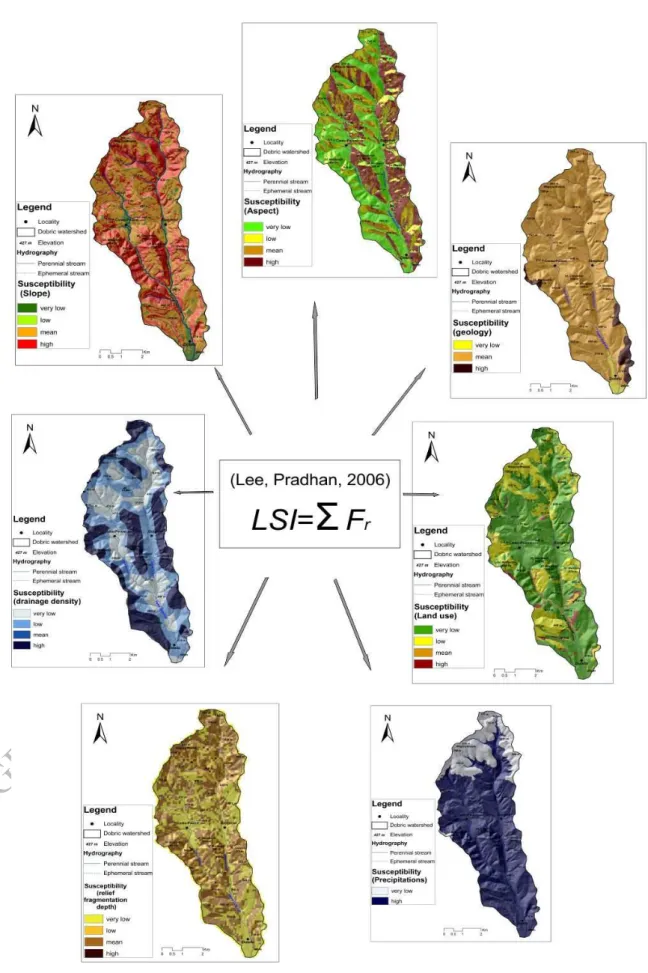
LSI=∑ F ⊇ (Lee, Pradhan, 2007) LSI – the landslide susceptibility index F ⊇ - the frequency rate for each control factor
The frequency rate model would not have found its utility without the existence of a high resolution DEM (3 m) where the landslides were displayed after being previusly measured in the field or on the 0.5 m resolution orthophotographs.
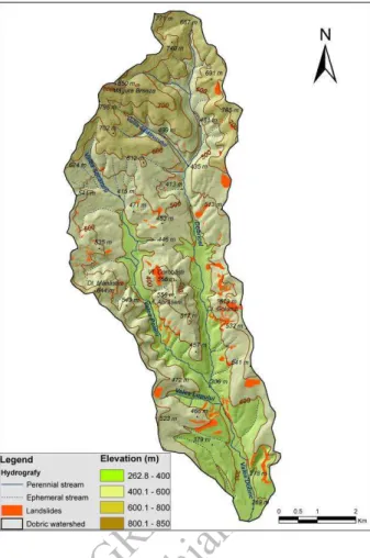
Fig. 2. The landslides distribution at the catchment area level
Other cartographical materials used were: geological maps, 1: 200 000 soil maps and Corine Land Cover 2006 data for the analysis of the land use distribution.
3. Factors leading to the occurrence of
landslides
The present distribution of the landslides represents a major element in achieving the susceptibility index. At the level of our study
unit we notice the high density of landslides in the following areas: Golumb Hill (left from the Dobricel rivulet), Purc rete (upstrem of the Dobricel village), La Corh (Corob şti Hill), the M n stirii Hill (to the right of the Poieni Valley), La Gheleşoaia and La Dumbrav (left from Dovric).
Their typology is diverse, from shallow landslides to the deep landslides (deep-seated landslides). The latter category includes the areas: Purc rete, La Corh and La Gheleşoaia. The last of these includes a small lake under accelerated silting process (Hognogi et al., 2012).
The geological composition is the first analzyed conditional factor and it presents a low diversity. This stand up in terms of predisposition to be engaged in the gravitational movements of the Neogene deposits.
Therefore, the Tortonian is highlighted more due to the low spatial distribution and the high slope values as follows: the Helvetian deposists support as well the gravitational movements of the layer packages.
The role of the slope display direction as a driving factor is materialized by the occurrence of and evolution of the phenomena under the conditions of partially under shadow and shadow slopes. We mainly refer to the Western, North-Western and North-Eastern slopes which benefit from a lower evaporation rate, as well as a slower melting of the slnow layer, which enables the increase of the seepage water quantity.
The slopes are one of the most important factors and present medium (6-20º) and high (20-40º) susceptibility in over 80% of the basin’s area, determining the typology of landslides.
The analysis of the distribution of landslides area in relation to the density of fragmentation reveals a predisposition of the low value index areas, which is normal, while most of the events occur in the delluvial deposits.
GEOGRAPHIA
NAPOCENSIS
AN.
VII,
nr. 2/2013
geographianapocensis.acad-cluj.ro
GEOGRAPHIA
NAPOCENSIS
AN.
VII,
nr. 2/2013
geographianapocensis.acad-cluj.ro
Of the land use categories, the highest susceptibility is presented by the areas covered with shrubs, followed by pastures and grasslands. The real situation is presented differently in that the areas where landslides occurred are mostly unusable, so that whether they are enhanced in terms of errosion or not, they are covered by shrub vegetation. However, one needs to mention that previous to the forest development, the shrub vegetation was almost completely absent.
Rainfalls as the conditioning factor in the activation and evolution of the phenomena, presents a real difficulty for evaluation, from the simple reason that it is not the average amount that is important, but the rainfall regime. In this direction, one proof is represented by the very low susceptibility of the areas, with an average multianual value of rainfalls exceeding 790 mm, while the 670-790 mm interval presents a maximum favorability.
4. Conclusions
4.1. The susceptibility map
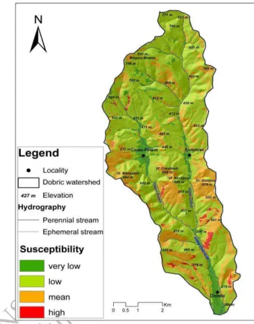
The summing of susceptibility for each particular factor was materialized by the generation of a general landslides susceptibility map of the study area which includes the Dobric catchment area where 23% of the territory (9.18 sqkm) classifies as a medium susceptibility class, while 1.24% (0.49 sqkm) presents a very high susceptibility.
We notice that the areas with maximal landslides predisposition have mainly a South-Western or South-Western orientation, overlapping the areas with high density of the same phanomena occurred so far.
4.2. Results
One mentioned the high appreciation of the frequency rate model at national and international level for the identification of the areas where future landslides might occur. These phenomena lead to the decrease of the existing resources (soil, vegetation), and in our case they may affect the infrastructure and the built areas.
It is necessary to add to these appreciations an insert regarding the possibility to use the model more accurately for certain landslides.
Fig. 4. The landslides susceptibility map in the Dobric catchment area
The motivation of this statement results from the different contexts of the occurrence and evolution of these phenomena, among which the most relevant are the amount and especially the temporal distribution of the rainfalls and the slope. Therefore, shallow landslides need heavy rainfalls during a very short period of time (hours). To these one may add the oragious phenomena (Cocean 2006), while the deep landslides need heavy rainfalls distributed over a longer period of time, simultaneously with the melting of the snow cover. Referring to slopes, one may notice that their high values have a favourable context for shallow landslide, while in case of the deep-seated landslides, for example, the relatively low slopes alternating or not with the steep slopes represent sine qua non conditions in their occurrence.
GEOGRAPHIA
NAPOCENSIS
AN.
VII,
nr. 2/2013
geographianapocensis.acad-cluj.ro
provide supperior results, while the existence of the data related to the duration and temporal distribution of the heavy rainfall periods, as well as of a high resolution DEM, as that used herein, provide a better safety regarding the results quality.
References
[1]. ARGHIUŞ, C., (2010), Culmea şi Piemontul Codrului – Studiu geomorfologic, Tez de doctorat, Cluj-Napoca;
[2]. COCEAN, P., (2006), Rolul fenomenelor orajoase (tunetul, trăznetul) în declanşarea alunecărilor de teren, Revista de geomorfologie, Bucureşti;
[3]. COCEAN, P., DANCIU, Rodica, (1994) Contribuţii la studiul proceselor geomorfologice din bazinul Văii Ilişua, Studia Universitatis Babeş-Bolyai, Geografia, XXXIX,1, Cluj-Napoca
[4]. HOGNOGI, G., NICULA, G., ŞIMON, A., (2012), Alunecările de teren de tip glimee din bazinul inferior al Râului Ilişua, Geographia Napocensis, vol. I, p. 31-42, Editura Casa C r ii de Ştiin , Cluj-Napoca;
[5]. LEE, S., PRADHAN, B. (2007), Landslide hazard mapping at Selangor, Malaysia using frequency ratio and logistic models, Landslides, 4, pp. 33-41.