175 Maria Helena Maia and Alexandra Cardoso
Centro de Estudos Arnaldo Araújo/ Arnaldo Araújo Research Centre - ESAP, Porto, Portugal
Abstract
Between 1945 and 1965, thirty-three new agricultural pueblos de colonización [colonization villages] were built in the Spanish Tagus Valley under the action of the Instituto Nacional de Colonización (INC: 1939-1971).
Associated with works of hydraulic infrastructures and soil transformation for an intensive use of irrigated crops, these villages deeply shaped the rural landscape in the scope of an intentional modernization process of the countryside.
However, this process also contributes to achieve the agrarian utopia of the authoritarian catholic and conservative policy of Franco’s regime. In addition, the changed status of the settler into a small landowner and the notions imported from more urban context reflected in schemes of rural planning were crucial in order to avoid the exodus towards the city.
This paper aims to explore the patterns used in the conception of the pueblos and their relation with national identity building process in the context of similar processes occurred in the Southern Europe.
The relation between modernity and traditional references, both in urban shape and architectural design, will be explored, with special attention to the Civic Centre, a mandatory requirement of the pueblo’s programme, functioning as the core of the urban fabric. Its composition and facilities architectonic options will be analyzed, as well as its role in the power rhetoric.
The articulation with coeval theoretical debates and external models will be used to understand in which level the Spanish experience contributes to the international architectural culture and the regional process of appropriation of similar experiences from abroad in the Modern Movement context.
Keywords: pueblos de colonización, rural planning, Spanish inner colonization, civic centre, modernist landscape
Framework
In 1939, after the civil war and with the country devastated, ‘the regeneration of the Spanish rural world is the excuse used by the new regime for the construction of the new order [...] and the agrarian colonization assumed by the
176
Franco regime acquired from the beginning the condition of mission'. (Flores Soto, 2013b, p p.452-453)
The value of the countryside and the improvement of rural man's living conditions will be increased by an intentional modernization process of land reform, focusing on a broad investment in intensive irrigated crop, on which high levels of agricultural profits are expected.
For this purpose, the hydrographical basins were reorganized to improve more easily the irrigation possibilities through large-scale hydraulic infrastructures. The association between hydraulic works and inner colonization is deeply rooted in Spanish rural territory management since 19th century. Thus, in 1865, with
the Hydrological recognition of the Ebro basin, the construction of new settlements was already clearly understood as part of hydraulic policy. (Monclús & Oyón, 1988).
In fact, it was the change of agrarian quality of the land that turns necessary to fix permanent agricultural labour in the new irrigated areas, which were divided into family units of cultivation. Consequently, about three hundred new rural villages of modern morphology were built in rural environment, involving around 40.000 families.
The implications of such development had consequences in the status of the settler who changed into a small landowner, in order to avoid the exodus from countryside to city, accordingly with the authoritarian political interests of Franco.
To implement the Spanish agricultural policy, the Instituto Nacional de
Colonización (INC: 1939-1971) [National Institute for Colonisation] was the
official administrative entity, empowered by the Ministry of Agriculture, to operate a set of actions strongly structuring. A radical transformation of the territory such as the hydraulic and the road works, the deforestation, the earthwork, or the changing the native vegetation, as well as the construction of the settlements, gave rise to a new rural landscape.
Under the action of the INC their architects acquired a privileged knowledge in the field of the rural planning practice.
177
Traditional options evolved into more modern conceptions such as the modular grid, the hierarchy of streets, the city block, the square, the public space or the gardens, which came to shape more urban type interventions, however dimensioned within the scale of the rural landscape.
The INC’s decision for concentrated settlements provided the patterns of an urban social life, education, health, leisure, administrative services, infrastructure network, ‘that would definitively assimilate the living conditions of the countryside to those of the city[...] equating the agrarian environment with the urban.’ (Oyón, 1985, p.246) The will of building a community was fundamental.
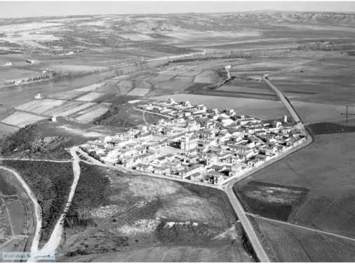
Consequently, autonomous pueblos were raised around a civic centre, with its physical limits clearly outlined over the agricultural land plots, presenting themselves as an urban front in relation to the surrounding countryside.
Being the civic centre the core of the pueblo, its place, form, public space design and architectural features of the buildings that surround it act as a mechanism of organization of the urban fabric morphology, setting to each colonization village its own identity.
To study the civic centre´s scheme(s), both in relation to its ideological concept as also to architectural and social program, the thirty-three pueblos of the Tagus Valley, built between 1945 and 1965 were the scope of inquiry1.
Extending through three provinces – Madrid, Toledo and Cáceres – these settlements, in which twenty architects were involved in its planning, reflect the whole chronological period of the INC in which it seems possible to identify different stages of activity ‘foundations, maturation and development, and abandonment of the implementation of population policies’ (Pérez, 2006, p.481-504) in the accomplishment of the rural colonization.
Even before the INC, a ‘debate regarding architecture and urban development conducted during the first third of the 20th century was reflected chiefly in the
1In addition to the bibliography, this work is based on graphic material collected on file, field work
178
architectural proposals for colonization villages, which were in turn based on the work being done by different water authorities.’(Sambricio, 2007, p.13)
Structuring the Colonization: planning, plans and pueblos
Beyond the challenge of modernization, the field was also an urgent problem to be resolved in its socio-political and economic aspects. Aware of this reality, the idea disseminated by the INC was ‘to transform the collective exploitation, from the agricultural farms, into individual ones, giving to each settler a plot of economic independence’, being one of its ‘fundamental objectives to provide social stability to the Spanish countryside’. (INC, 1964a)
In order to carry out the intended economic and social land reform, technical planning tools were created, with a different scale of intervention, implementation phase and level of detail.
Declared as a high national interest, the colonization of an irrigated area, the INC drafted the corresponding 'General Colonization Plan' [...] which establishes the technical and economic foundations of the new agrarian structure [...] the description of the works and the definition of the most appropriate units of exploitation [...] determine approximately the number of families that can be installed [...] as well as the implantation and characteristics of the new settlements. (Monclús & Oyón, 1983, p.72)
It is also in this General Plan that the selection of the settler is defined, and the areas assigned to tierras en reserva, lands that remained under the landowner propriety, and to tierras en excesso [lands in excess], resulting from the expropriation of latifundia.
If the general plan outlines the main purposes and actions, the ‘Coordination Plan of Works’ and the ‘Project of Parceling’ are its modus operandi. On the one hand, irrigation and sanitation networks and service roads are planned to ensure the basic infrastructures to each unit of exploitation. On the other hand, the location of the settlements is defined, positioned in the gravitational centre of the plots distributed to each settler.
179
Equidistant, within a radius of influence of 2.5km, (the so-called modulo carro [cart module]2, the pueblos were ‘all identical in importance and without
hierarchy levels’. (Flores Soto, 2013b, p.464) Together, they formed a wide net system among the territory, close to large areas of private cultivation, which itself would benefit from such an organization.
The notion of family unit type in which an urban lot is associated with a land plot of agricultural exploitation will give rise to a new agrarian structure. The
legal-administrative link between the settler and the INC will be significant in the possibility of expansion of the pueblo itself
In the latter case, two types will be predetermined: (1) non evolutive pueblos with a fixed number of settlers and with little expectation of expansion; (2) evolutive pueblos with two stages of execution, usually located near the large areas of irrigation. Enlargement zones for housing and urban voids to build new facilities in a second phase have been set from the beginning in the urban design.
At last, the ‘Plans of Works’ materialize the great options of the internal colonization. It is through them that the regime will disseminate its propaganda in relation to the former ‘agrarian reform that had been carried out in the country based on a simple redistribution of the land, by a policy of interior colonization, in which social progress is firstly based in the economic improvement achieved through the execution of the necessary works of transformation of the rural environment’. (INC, 1964b)
Two groups of execution projects were included in these plans: secondary infrastructures and pueblos. The INC established clear guidelines3 for the new
settlements with normative value, both for the urban design and for the functional program of the buildings,divided in three typologies: (1) housing and agricultural annexes for the settlers, (2) handicrafts and commerce, (3) official buildings.
2 This module corresponds to the most convenient route between the dwelling and the associated
land.
180
Considering the size and type of the settlements, the plan determines which equipment to build, administrative and social services to support the settlers, as well as the number of handicrafts and commerce. However, there is always a common denominator in all of them: the church with its vertical bell-tower visible from afar is a modern architectural landmark that confers specific identity of each one of them.
The ‘Plan of Works’ also determines the formal composition of the main square that materializes the civic centre, in the sense of creating representativeness and image of impact.
The general instructions (formal and functional) laid down by the INC directly to the urban matrix, namely differentiated circulation for carts and livestock and for pedestrians, housing typologies for settlers or the placement for the civic centre and the composition of its public buildings have resulted in a somewhat rigid matrix regarding the design of these settlements.
These orders of an alleged homogeneity seem not to be dissociated from the main objective of the regime to implement a nationalist policy of colonization recognizable in the new rural landscape deeply transformed for this purpose. Almost all the pueblos situated in the Tagus valley were located on flat topography4, and the layout of the villages has been projected in such a way as
to involve the least possible amount of earthmoving. They were characterized by a regular layout with an orthogonal grid of streets, lots, blocks and a central square, resulting from the application of the INC guidelines.
Consequently, architects were faced with the problem of the rigid structure of the grid planning imposed by the rectangular shapes of the parcels. Thus, most of them tested some diverse urban forms as an attempt to avoid ‘the depressing monotony’ of the checkerboard5.
In Vegaviana, an experience without parallel or continuity was tested, in which the settlement was incorporated in a clear intention with the landscape. The pre-existing vegetal material, particularly the traditional oaks of the zone but also
4 Belvis del Jarama, Rincón de Ballesteros or Pradochano are some of exceptions. 5 Bernuy (1946), Talavera la Nueva, Talavera la Nueva or Pradochano.
181
the undergrowth (red lavender or thyme) was used as an instrument to organize the public space. The ‘project aims to conserve the general present appearance of the site and its surroundings as much as possible, and its urban layout has been designed to respect wooded areas inside the village.’ (Fernández del Amo, 1954)
However, these different design experiences ‘there is a formal unity and a coherence of language between housing and facilities, resulting from a predefined process: the same architect was in charge of the general planning [...] In addition, the systematic geometry of volumes and the use of white walls [...] is an attempt towards a rationalist architecture.’ (Cardoso et. al, 2018.)
Civic Centres: places of representation
Based on its dimension, the INC established two categories for the new settlements.
Rural nucleus or aldea for 25 to 35 settlers’ houses with its agricultural
annexes. The official buildings included a convertible school in chapel, the teacher’s house and a small administrative building. ‘For an initial population of 150 to 200 inhabitants, one can satisfy his [the settler] most elemental spiritual and learning requirements.’ (Tamés Alarcón, 1948, p.423)
Pueblo for 80 to 150 houses with a broader and self-sufficient administrative
and social program: Ayuntamiento [Town hall], Church, Social Building for recreation and cinema, unitarian schools, Hermandad Sindical [Union building], Hogar Rural, place of ideological orientation for the Youth Front of the National Movement, houses for INC’s technicians, doctor and teachers and
10% of
traders and craftsmen.The civic centre was a mandatory requirement of the programme, materialized in a geometric place located in a central area, where the streets depart and structure the urban pattern, with the Church and the Ayuntamiento standing on its main axis in line with the roads. ‘If the pueblo is in the landscape as a mass
182
densification built, the square recognizes itself in the urban mass because it is a ‘void’ inside the constructed one.’ (Flores Soto, 2013a, p.144)
Comparing the INC’s main guidelines with the different phases of its implementation, one will allow framing common factors or different experiences within traditional references and modernity, in the planning schemes in the Tagus valley case study.
In the 1940s, throughout its formation phase and with the technical staff in consolidation, the plans were based on an ancestral reference structure – the Plaza Mayor [Main Square] and an uniform gridiron layout, whose formalization seeks to rely on the traditional architecture of the region ‘absorbing and understanding its good features, both in constructive and aesthetic order.’ (Tamés Alarcón, 1948, p.423)
In Bernuy, a 1946's small pueblo for 36 settlers, Jiménez Varea concentrates in the Civic Centre the set of all official buildings. 'The small size of the village makes it impossible to separate the civil area from the religious area, and these two spaces have been combined to form the typical Main Square […] made as representative as possible. (Jiménez Varea, 1946).
183
Its almost square form encloses three of its fronts in a volumetric set in which ‘an attempt has been made to keep the facades of the square as compact as possible. (Jiménez Varea, op. cit) The continuous portico stabilizes the composition of the facades and reinforces the scenic character of this space, similar to a Plaza-Mayor, ‘which is envisaged as a meeting point and place for relaxation.’(Jiménez Varea, op. cit)
In this proposal the settlers’ houses are also part of its composition. Usually selected the typologies with two floors, due to volumetric scale issues, they are located in continuous front or in the corners. This solution will be frequently adopted in a clear intention to join the housing in the settlement, thus differentiating the Spanish matrix from other contemporary experiences of internal colonization.
At the turn of the decade, in 1951, Fernández del Amo, in Belvis del Jarama, explores a new civic centre organization, partly induced by the rugged topography along of the hill. An organic layout with the physical separation of the Church and the Town Hall into places of representation of religious and civil power, divided by the main access, was implemented. Symbolically they ‘will occupy the most prominent position at the highest point. The Civic Area will be built at the top, presided by the church and with the bell tower standing at the end of this central entrance thoroughfare.’ (Fernández del Amo, 1951)
In fact, this decade begins a second more operative phase with most of the pueblos to be designed and constructed and the plots to be distributed to the settlers.
An important reference was Torre de la Reina (Sevilha), a model pueblo to be followed, designed in 1952 by Tames Alarcon, in which he put into practice his guidelines while director of the INC’s Architecture Service6. The civic centre
confined in a semi-enclosed geometric central square, the official buildings connected through a continuous portico in reference to the traditional scheme of plaza and calle mayor with visual emphasis into the bell-tower, the hierarchy of
6Created in 1941, it was its director, the architect Germán Valentín-Gamazo until 1943, author of
Puebla de Argeme (1957, Cáceres). Subsequently Jose Tames Alarcon assumed its direction until its extinction in 1971
184
the circulation system or even the framed perspectives can be found in many of the settlements of the Tagus valley. Such as Alberche del Caudillo (Jiménez Varea, 1952), La Moheda (1953) and Talavera la Nueva (1954) by César Casado de Pablos, Rincón de Ballesteros (Carlos Sobrini Marín, 1953) or Rosalejo (José Manuel González Valcárcel,1956).
The central square is also marked by a scenic interest in social representation in which ‘The INC encourages social life in the new pueblos by establishing sports competitions and fiestas patronales [patron saint festivals].’ (INC, 1964b)
In a different approach, some experiences of a more decomposed and less closed civic centre were tested. The official, religious and craftsmen’s buildings are not always in a compacted group, yet they organize courtyards or open spaces of influence, usually linked by green zones, to form a civic, religious and commercial area clearly identifiable. Miramontes (1956) and Barquilla de Pinares (1957) by Agustín Delgado de Robles y Velasco, Santa Maria de las Lomas (Rafael de la Fuente et al., 1957), Tiétar del Caudillo (Pablo Pintado Riba, 1957) or Valdesalor (Jiménez Varea, 1960) were some examples in which levels of modernity were achieved.
This leads to an architecture that acts as “mediation" between the representation of the symbolic space of the regime propaganda (the rules) and the space of an integrated use (appropriation).
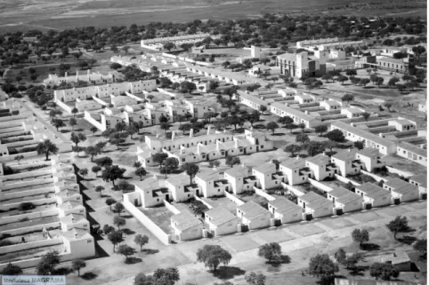
Meanwhile, a group of INC’s architects such as Alexandro de la Sota, Fernández del Amo or Jose Antonio Corrales motivated by other concerns will reconsider the connection between tradition an modernity into a new perspective. The ‘search for a more abstract urban form to accompany the modernization of the vernacular made sure that the grid and the closed urban block could abandon its absolute character and be replaced by more organic schemes and closer relations between city and nature.’ (Lejeune, 2006, p. [6])
This organic integration between the part and the whole, now transposed to the civic centre and settlement relationship, is fundamental to the morphology of Vegaviana (1954, Fernández del Amo). In accordance, the ‘public buildings appear exempt within the greater space that sustains the civic centre. Although
185
the place no more functions as closed, or delimited, its buildings maintain their uniqueness, and the symbolic referents.’ (Álvaro Tordesillas & Meiss, 2013, p.41).
Figure 2. Vegaviana, Fernandez del Amo ©Mediateca MAGRAMA
A last phase arises from the middle of the 1960s until the extinction of the INC in 1971. ‘The rigid schemes of the beginning, the geometric definition of the image and perimeter, gave rise to greater flexibility into the its geometry, unity and closure, though the gestures that make the square recognizable in the urban set remain invariant.’ (Flores Soto, 2013a, p.150).
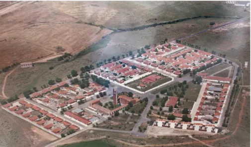
The dematerialization of the civic centre has the purpose of expressing a physical and visual relation to the whole urban fabric through space transition (open porticos) or spaces of opening in reference to other official buildings. In Pradochano (1965, Agustín Delgado de Robles y Velasco) the central religious, social and administrative area is positioned at the highest point of the pueblo and is surrounded by a wide public space (green and paved) that articulates organically with the structure of the main circulation axes. Another characteristic of this implantation is the visual relation between pueblo and cultivated field that in previous phases was surrounded by a green belt.
186
Figure 3. Pradochano, A. D. de Robles y Velasco © Ayuntamento
Spanish contributes to Southern European inner colonization
Spain and Italy have a major place in the modern inner colonization, particularly in Southern European process, with its roots in the 19th century and even before
it.
However, it was the Italian Pontine Marches colonization process that played a key role as a model to be followed. There are some relates of Portuguese and Spanish technicians’ visits to its new towns and settlements, and the rhetoric of their civic centres were also well known. The civic centre is hierarchical set of the official buildings: the Casa del Fascio and the Church, schools, services and housing for technicians, teachers and doctors, clearly autonomous in relation to the settlers’ houses, built in their agricultural plots along the main accesses, conforming a type of a dispersed settlement.
This urban scheme model can be found in Libya’s Italian colonization settlements and in some of the Portuguese cases, such as the agricultural colony of Gafanha. However, it was the visit to the Spanish Badajoz Plan that converts Portuguese technicians to the benefits of a concentrated model for the settlements.
In fact, a compact scheme surrounded by agricultural plots, instead of a dispersed one, had already been proposed and debated in Spain, even before
187
the formation of the INC. Greece also chose this type when, in the 1920s, was confronted with the necessity of host c. 1,2 million people, resulting from the compulsory exchange of minorities between Greece and Turkey.
We don’t know yet, if the Greek case was known by Spanish architects, but in both cases the grid as a settlement layout solution is dominant, always with a square associated to collective facilities, as core of the village.
One can easily understand the presence of the square in almost all inner colonization villages of south Europe, as it was deeply rooted in their tradition. The exception is the Portuguese case, were the colonization settlements civic centre is frequently less defined with fewer communitarian services as well. With different significances, school and church are often presents. Nevertheless, the alphabetization and educational mission of Portuguese, Spanish and Italian school is different from the Greek case that had the huge role of Hellenization of a culturally Turkish population. The same happen with the church, ancestral place of devotion for all, but also sign of national identity in the Greek case.
Final Remarks
The agricultural inner colonization in South Europe share with different levels of combination, layout solutions and implantation schemes in which the civic centre has an important role as the core of the settlement life and space of its identity. However, when we talk about identity issues in relation to these new settlements, different perceptions come around. In Spain, one can talk about the civic centre has one of the major elements of identification of the village in its singularity among others, while identity in Greece has a broader meaning about the signs of belonging to a larger community, it means, Greece as homeland. In all cases, the civic centre acts symbolically both as a stage for central and institutional power representation and as a space that generates a sense of sharing, in an outline of nationalism expression.
188 Acknowledgements
The presentation of this work was funded by national funds through FCT - Fundação para a Ciência e a Tecnologia, I.P., within the project UID/EAT/04041/2016 and it is based on the research conducted under the project MODSCAPES - Modernist Reinventions of the Rural Landscape (HERA.15.097). This project has received funding from the European Union's Horizon 2020 research and innovation programme under grant agreement No 649307.
References
Álvaro Tordesillas, A. & Meiss, A. (2013). El Corazón de los Pueblos de Colonización,
Boletín Académico 3. Revista de investigación y arquitectura contemporânea, Escuela
Técnica Superior de Arquitectura. Universidade da Coruña.
Calzada Pérez, M. (2006). La colonización interior en la España del siglo XX. Agrónomos
y arquitectos en la modernización del medio rural, PhD Thesis, Departamento de
História, Teorías e Composición Arquitectónicas, Universidad de Sevilla.
Cardoso, A. et al (2018). Rural Housing as Field of Modernist Experiences, in Modernism,
Modernisation and the Rural Landscape, Proceedings of the Conference, Estonian
University of Life Sciences, Tartu, 11-13 June 2018, (in print).
Fernández del Amo, J.L. (1951). Project Report of Belvis del Jarama in Calzada Pérez, M. 2007 Pueblos de Colonización II. Guadiana y Tajo. Itinerarios de Arquitectura 04, Fundación Arquitectura Contemporánea (CD).
Fernández del Amo, J.L. (1954). Project Report of Vegaviana in Calzada Pérez, M. 2007
Pueblos de Colonización II. Guadiana y Tajo. Itinerarios de Arquitectura 04, Fundación
Arquitectura Contemporánea (CD).
Flores Soto, J.A. (2013a). La construccion del lugar. La plaza en los pueblos del Instituto Nacional de Colonizacion, Historia Agraria, 60, 119-154.
Flores Soto, J.A (2013b). Aprendiendo de una arquitectura anónima: influencias y
relaciones en la arquitectura española contemporánea: el INC en Extremadura, PhD
Thesis, E.T.S. Arquitectura (UPM).
INC (1964a), XXV Aniversario del Instituto Nacional de Colonización, Photographic Album of Talavera de la Reina, https://www.mapa.gob.es/es/ministerio/archivos-bibliotecas-mediateca/mediateca/colonizacion.aspx
INC (1964b), XXV Aniversario del Instituto Nacional de Colonización, Photographic Album of Cáceres, https://www.mapa.gob.es/es/ministerio/archivos-bibliotecas-mediateca/mediateca/colonizacion.aspx
Jiménez Varea, M. (1946). Project Report of Bernuy in Pérez, M.C. 2007 Pueblos de
Colonización II. Guadiana y Tajo. Itinerarios de Arquitectura 04, Fundación Arquitectura
189
Lejeune, J-F (2006). Fondazioni, Poetica Rurale e Modernità, Agorà a Ciello Scoperto:
Città di fondazione in Spagna, 1944-1969, Fondazione CE.S.A.R.
Monclús, F.J. & Oyón, J.L. (1983). Colonización agraria y urbanismo rural en el siglo XX: la experiencia del Instituto Nacional de Colonización, Ciudad y Territorio, nº 57/8, 67-82. Monclús, F.J. & Oyón, J.L. (1988). História y Evolución de la Colonización Agraria en
España, vol I: Politicas y Tecnicas en la Ordenación del Espacio Rural, Instituto de
Estudios de Administración Local (ed)
Oyón, J.L. (1985), Colónias Agricolas y Poblados de Colonizacion - Arquitectura y
Vivienda Rural en España (1850-1965), PhD Thesis, Universidad Politécnica de Barcelona
Sambricio, C. (2007). Sesenta años de política de colonización en la España agraria in
Itinerários de Arquitectura 04 - Pueblos de Colonización II: Guadiana y Tajo, Editor: Gaia
Redaelli, Publisher: Fundação de Arquitectura Contemporânea, 9-15
Tamés Alarcón, J. (1948). Proceso Urbanistico de Nuestra Colonizacion Interior, Revista
Nacional de Arquitectura, Ano VII nº83, COAM (ed), 413 424
Authors identification
Maria Helena Maia holds a PhD in Modern Architecture and Restoration (ETSA/UVa). She is a full-time tenured assistant professor and deputy-director at ESAP – Escola Superior Artística do Porto. She also is an affiliated researcher and director of Arnaldo Araújo Research Center (FCT uRD 4041). She has been publishing on architectural theory and history area, received two prizes by published books and participated in several research projects, such as “Popular Architecture in Portugal. A Critical Look”. Currently, she is one of the PIs of the ongoing project MODSCAPES – Modernist Reinventions of the Rural Landscapes (HERA.15.097)
Alexandra Cardoso: architect (1994) by FAUP, Portugal. She began her work with Pedro Vieira de Almeida in 1996, in the field of architectural theory and criticism, being an affiliated researcher of Centro de Estudos Arnaldo Araújo (FCT uRD 4041) since 1999, of which she was the Director (2003-2010). She was involved in national/international projects: “The ‘Popular Architecture in Portugal’. A Critical Look” (2010-2013); “Photography, Modern Architecture and the ‘School of Oporto’: Interpretations around Teófilo Rego Archive” (2013-2015); “Southern Modernisms” (2014-2015); “Portuguese Participation in CIAM X” (2014). Currently, she is researcher of the transnational research project: MODSCAPES – Modernist Reinventions of the Rural Landscape (HERA.15.097)