Faculdade de Ciências
Departamento de Biologia Animal
Planning and management of Marine
Protected Areas: methodological
approaches to cope with data scarcity
Marisa Isabel Santos Batista Pereira
Doutoramento em Biologia
Especialidade de Biologia Marinha e Aquacultura
Universidade de Lisboa
Faculdade de Ciências
Departamento de Biologia Animal
Planning and management of Marine
Protected Areas: methodological
approaches to cope with data scarcity
Marisa Isabel Santos Batista Pereira
Tese orientada pelo Professor Doutor Henrique Cabral,
especialmente elaborada para a obtenção do grau de doutor em
Biologia (especialidade de Biologia Marinha e Aquacultura)
Doctoral dissertation in Biology
(specialization in Marine Biology and Aquaculture) presented to the University of Lisboa
Dissertação apresentada à Universidade de Lisboa para obtenção do grau de Doutor
(especialidade Biologia Marinha e Aquacultura)
Marisa Isabel Santos Batista Pereira
2014
O futuro da Humanidade será tão melhor quanto melhor cuidarmos dos ecossistemas.
TABLE OF CONTENTS
A
BSTRACT AND KEYWORDS 9R
ESUMO E PALAVRAS-CHAVE 11R
ESUMO ALARGADO 13L
IST OF PAPERS 19C
HAPTER 1 General introduction 21C
HAPTER 2Assessment of cumulative human pressures on a coastal area: integrating information for MPA planning and management
35
C
HAPTER 3Assessment of catches, landings and fishing effort as useful tools for MPA management
65
C
HAPTER 4A framework for a rapid assessment of MPA effectiveness based on life history of fishes
109
C
HAPTER 5An overview of SW Europe Marine Protected Areas: factors contributing to their effectiveness
161
C
HAPTER 6Final remarks and future perspectives
185
9
A
bstract
Changes in ecosystems structure and function due to high impacts of human pressure on oceans have led to the increasing numbers of Marine Protected Areas (AMP) as tools for conservation and fisheries management. Habitat recovery, increases in density, size and biomass of organisms within MPA and beyond their limits have often been found. However, MPA effectiveness is compromised by the interaction of several factors, such as the inadequate conduction of planning and management processes and the lack of appropriate scientific datasets to support decisions. In order to contribute to MPA effectiveness, several approaches to cope with data scarcity and low accuracy were developed and then applied to different case studies. Data analyses were mainly based in published studies and official datasets. Geographic information systems and multivariate statistical analyses were the main methods applied. Cumulative effects of human activities on the Portuguese coast were assessed and showed that implemented MPA are usually under high human impacts from different sources (e.g. fisheries, land-based activities). Small-scale fisheries are often the main economic activity occurring in MPA and a new monitoring method combining data on spatial distribution of fishing effort, on-board observations and official landings records revealed to be an effective approach to the assessment of MPA impacts on small scale fisheries. A framework based on fish life history and habitats used was developed and showed this approach can indicate areas that would potentially increase the effectiveness of protection measures. Finally, the status of marine conservation in SW Europe and the factors mostly contributing to their effectiveness were assessed and showed that high MPA effectiveness is usually related with strong stakeholders support, with suitable goals, management and enforcement. Overall, this thesis results highlighted that the investment in strategies aiming at maximizing MPA performance is urgent and crucial in a context of increasing MPA coverage.
Keywords: Sustainable management of marine resources; marine protected areas; small-scale fisheries; fish’s life history; anthropogenic pressures.
11
R
esumo
Os impactos humanos nos ecossistemas marinhos têm provocado alterações na sua estrutura e função, levando ao aumento do número de Áreas Marinhas Protegidas (AMP) como ferramentas de conservação e gestão de pescas. A recuperação de habitats e o aumento de densidade, tamanho e biomassa dos organismos dentro e fora dos limites das AMP são resultados frequentes. A eficiência das AMP é frequentemente comprometida pela conjugação de fatores como a implementação inadequada dos processos de planeamento e gestão e a falta de informação científica apropriada para suporte à tomada de decisões. Desenvolveram-se diferentes abordagens, aplicadas a vários casos de estudo, pretendendo contribuir para o sucesso das AMP quando a informação disponível não é a ideal. Este trabalho baseou-se principalmente em dados publicados ou de fontes oficiais. As metodologias de análise foram Sistemas de informação geográfica e estatísticas multivariadas. O estudo dos efeitos cumulativos das atividades humanas na costa portuguesa revelou que as AMP estão sob elevadas pressões provenientes de diferentes fontes (e.g. pescas, fontes terrestres). Desenvolveu-se um método de monitorização de pescas combinando esforço de pesca, observações a bordo e desembarques oficiais que revelou ser apropriado para uma monitorização eficaz das AMP. Utilizou-se uma metodologia inovadora que integra informação sobre os habitats utilizados durante o ciclo de vida das espécies e habitats protegidos e concluiu-se que esta permite maior eficácia na escolha das zonas a proteger, contribuindo para a eficiência das AMP. Por fim, as características das AMP do SW europeu foram analisadas e foram identificados os fatores que contribuíram para a eficiência das AMP existentes (i.e. apoio por parte dos utilizadores da AMP e maior adequabilidade dos objetivos, da gestão e de fiscalização). No geral, esta tese mostrou que no contexto atual é urgente investir em estratégias que maximizem o bom desempenho e a extensão da área abrangida por AMP.
Palavras-chave: Gestão sustentável dos recursos marinhos; áreas marinhas protegidas, pesca artesanal, ciclo de vida dos peixes, pressões antropogénicas
R
esumo alargado
Muitos dos ecossistemas marinhos encontram-se sob forte pressão humana, o que tem levado ao aumento das preocupações com a sustentabilidade da exploração dos recursos do Oceano, tornando inquestionável a necessidade de estabelecer estratégias para a conservação e recuperação de habitats e biodiversidade marinhas. A criação de Áreas Marinhas Protegidas (AMP) é um dos mecanismos mais utilizados na proteção do Oceano e têm sido globalmente consideradas como ferramentas adequadas quer para a conservação dos ecossistemas marinhos, quer para a gestão sustentável das pescas. O ambiente multidimensional (socioeconómico, cultural, político) onde as AMP se enquadram e os múltiplos objetivos que são estabelecidos dificultam muitas vezes o seu sucesso. A implementação eficaz de AMP está assim dependente do desenvolvimento adequado de todos os processos, desde o planeamento até à implementação e gestão. A boa condução destes processos implica à partida o envolvimento que equipas multidisciplinares e a participação ativa dos principais utilizadores da área em questão de forma a integrar decisões que reúnam consenso generalizado, uma vez que tem sido demonstrado em diversos estudos que a omissão das vertentes socioeconómica e cultural nestes processos leva, em geral, à contestação da AMP e ao incumprimento das regras implementadas, dificultando ou inviabilizando o sucesso destas zonas. A tomada de decisões e a adequada condução dos processos de implementação de AMP está ainda relacionada com a qualidade e adequabilidade da informação científica que lhes serve de suporte (e.g. características e distribuição espacial e temporal de habitats e espécies, caracterização socioeconómica das comunidades locais, dados da pesca). No entanto, na maioria dos casos, a informação científica de suporte não é a ideal, está dispersa por diversas fontes, não abrange as escalas temporais e espaciais necessárias, não engloba os vários grupos biológicos e não existe para muitas das questões socioeconómicas, entre outras lacunas. Assim, o objetivo geral desta tese é desenvolver metodologias que permitam utilizar de forma eficiente a informação disponível de modo a maximizar a sua utilidade nos processos envolvidos nas fases de planeamento e gestão de AMP e assim contribuir para o aumento dos níveis de sucesso destas áreas.
Esta tese é constituída por seis capítulos que correspondem a uma introdução geral sobre o tema da tese, quatro artigos científicos publicados ou em revisão em revistas
internacionais de arbitragem científica indexadas no Science Citation Index, que englobam abordagens mais específicas sobre aspetos do tema central da tese, e, um capítulo final em que são apresentadas as principais conclusões e perspetivas futuras.
No capítulo 1, introdução geral, são apresentadas algumas considerações sobre as atividades humanas que afetam o meio marinho e os seus principais efeitos nos ecossistemas marinhas; são apresentadas algumas das ferramentas de conservação, destacando-se as AMP; é feita uma breve apresentação que enquadra a sequência de eventos e documentos internacionais que têm marcado o desenvolvimento da ciência em torno das AMP a nível global e, por fim, são apresentadas algumas considerações sobre como deve decorrer todo o processo de planeamento, implementação e gestão das AMP de modo a que estas sejam potencialmente eficientes.
No capítulo 2 é desenvolvido um método de caracterização das atividades humanas ao longo da costa portuguesa (mar territorial). Numa primeira fase foram identificadas e mapeadas as principais atividades que ocorrem ao longo da costa (por exemplo pescas e náutica de recreio), ou que nela têm impacto direto (por exemplo pressão proveniente dos estuários), recorrendo a um Sistema de informação geográfica. Após a caracterização individual de cada atividade foram calculados valores de pressão cumulativa para diferentes zonas da área de estudo, nomeadamente para as AMP. Os níveis de pressão cumulativa mais elevados ocorreram em zonas mais próximas da costa (profundidade inferior a 30m), onde se localizam também as AMP estudadas. A maioria das AMP está localizada em zonas próximas dos maiores centros urbanos do país e as pressões que ocorrem nas zonas adjacentes são também elevadas. Nas AMP consideradas, as atividades mais relevantes foram as pescas e as pressões resultantes da influência das águas de transição (estuários). O índice utilizado constitui uma ferramenta de base nos processos de planeamento e gestão do meio marinho, nomeadamente nas AMP, uma vez que permite integrar informação sobre a localização e intensidade das atividades humanas existentes e assim minimizar as situações de incompatibilidade das atividades humanas com a conservação do meio marinho.
No capítulo 3 é feita uma avaliação dos efeitos da implementação da AMP da Arrábida (Portugal) nas pescas locais através da combinação de três tipos de informação: distribuição espacial do esforço de pesca na AMP, dados de capturas obtidos a bordo de algumas embarcações locais e dados oficiais de desembarques das embarcações licenciadas para pescar na AMP. As três fontes de informação foram analisadas conjuntamente para o período de 2004 a 2010, considerando o mesmo grupo de embarcações. A análise conjunta da informação mostrou-nos que os resultados obtidos
através da análise isolada de dados de desembarques em lota apenas permite a identificação de padrões gerais das capturas, uma vez que há grandes discrepâncias entre as capturas e os desembarques oficiais. Em termos gerais, verificou-se um aumento do esforço de pesca com covos, acompanhado
pelo aumento dos desembarques de
polvo. A utilização de redes diminuiu com a implementação da AMP e as capturas de
algumas espécies mais associadas a esta arte de pesca (por exemplo, linguados)
mostraram tendências mais constantes ao longo do tempo. Os desembarques globais (em
biomassa) aumentaram ao longo do período em análise. Apesar da discrepância entre
capturas reais e desembarques, a integração dos três tipos de informação referidos
revelou ser um método apropriado na caracterização da evolução da dinâmica das pescas
em resposta à implementação da AMP. O método utilizado pode ser muito útil no futuro,
se implementado num período de tempo mais alargado, com recolha dos três tipos de
informação em simultâneo e incluindo aumento do esforço de amostragem a bordo de
embarcações de pesca. Num contexto em que os recursos humanos e financeiros são
normalmente escassos, o método utilizado poderá ser útil também na determinação de
fatores de correção aos valores de desembarques oficiais, permitindo a sua
utilização futura como indicador da evolução das pescarias em AMP ou noutros contextos de gestão de pescas.No capítulo 4 desenvolveu-se um quadro conceptual de avaliação do potencial de uma AMP para ser eficiente na proteção da biodiversidade. O método integrou informação sobre a relação entre espécies e habitats, o ciclo de vida das espécies de peixes que ocorrem numa AMP e os seus grupos funcionais e a pressão a que os habitats estão sujeitos. O método parte do pressuposto que para proteger a biodiversidade existente, todos os habitats necessários ao desenvolvimento do ciclo de vida das espécies deveriam estar protegidos e sob baixos níveis de impacto e a sua finalidade é assim identificar as maiores falhas na proteção de determinados habitats e propor medidas que permitam a adequação da AMP aos objetivos de conservação da biodiversidade. O quadro conceptual foi também aplicado à AMP da Arrábida de modo a exemplificar os seus potenciais resultados práticos. Esta AMP demonstrou englobar habitats adequados ao ciclo de vida da maioria das espécies de peixes que nela ocorrem, no entanto, alguns habitats necessários como zonas de viveiro ou desova para algumas espécies de grande interesse comercial não estão englobados na AMP. Estes resultados são discutidos no âmbito da gestão adaptativa das áreas já implementadas. O quadro desenvolvido é útil sobretudo
como um método de suporte à tomada de decisões precoces no que diz respeito à implementação ou adequação das medidas de gestão de uma AMP uma vez que permite uma rápida identificação de medidas prioritárias para o cumprimento dos objetivos da AMP ou reconhece a necessidade de adaptar esses objetivos.
No capítulo 5 compilou-se informação sobre as características gerais das AMP existentes (idade, área total, área de total interdição, objetivos, localização e gestão) no SW europeu (Portugal, Espanha e França) de modo a avaliar o estado geral de conservação destas áreas em relação ao exigido em diversos documentos internacionais. Para além desta caracterização geral foram feitos questionários aos gestores das AMP consideradas, pedindo-lhes uma caracterização e uma perceção da adequabilidade dos processos de planeamento, gestão, monitorização, governança e fiscalização das suas AMP. As respostas obtidas foram analisadas de modo a identificar os fatores que mais contribuem para maiores níveis de sucesso global das AMP. Verificou-se que a maioria das AMP da área de estudo têm dimensões reduzidas (cerca de 50% das áreas tem menos de 20 km2), localizam-se em zonas costeiras e têm normalmente uma multiplicidade de objetivos, desde a conservação de espécies e habitats até ao desenvolvimento de diversas atividades económicas (e.g. pesca profissional, naútica de recreio, pesca de recreio, mergulho). Apenas 9% das AMP tem mais de 1000 k m2 e a sua distribuição na área de estudo é bastante desigual (maioritariamente nos Açores e França). Globalmente, 46% das AMP e 59% da área coberta foram designadas nos últimos cinco anos, no entanto, o número de áreas de total exclusão de atividades foi bastante mais reduzida. O suporte das populações locais, a adequabilidade dos objetivos, da gestão e de fiscalização sobressaíram como os fatores que mais contribuíram para uma maior eficiência das AMP estudadas. A integração dos resultados permitiu concluir que apesar dos indicadores serem positivos, existe ainda uma falta de coerência, representatividade e eficácia das AMP implementadas. Assim, sublinha-se neste capítulo a necessidade de ampliar a área atualmente coberta por AMP, tendo contudo em atenção a integração das novas áreas e medidas de gestão com as atualmente existentes, de modo maximizar a representatividade e coerência das redes de AMP. Estas redes deviam incluir áreas, potencialmente de dimensão reduzida, que conferissem maiores níveis de proteção a zonas “chave” para a conservação dos ecossistemas marinhas. A necessidade de melhorar os programas de monitorização e adequar as medidas de fiscalização foi também evidente.
No último capítulo, apresentou-se um resumo das principais conclusões obtidas nesta tese e tecem-se comentários sobre futuras abordagens, nomeadamente sobre a
necessidade de recolher informação mais detalhada que permita definir com maior exatidão as áreas que efetivamente podem contribuir mais para a proteção dos ecossistemas marinhos permitindo otimizar as relações de custo-benefício inerentes à implementação e gestão de AMP. A implementação de métodos padrão de monitorização das AMP, contínuos no tempo, que possam ser integrados e permitam no futuro uma avaliação global dos sistemas de AMP implementados e identificação das maiores necessidades de conservação e a adaptabilidade das medidas de gestão.
19
L
ist of papers
This thesis is comprised by the papers listed below, each corresponding to a chapter (Chapters 2 to 5). The author of this thesis is the first author in all papers and was responsible for conception and design of the work, field surveys, sample collection and processing, data analysis and manuscript writing of all the papers. Remaining authors collaborated in some or several of these procedures. All papers published were included with the publishers’ agreement.
CHAPTER 2
Assessment of cumulative human pressures on a coastal area: integrating information for MPA planning and management
Marisa I. Batista, Sofia Henriques, Miguel P. Pais, Henrique N. Cabral Published in Ocean & Coastal Management 102: 248-257 (2014)
CHAPTER 3:
Assessment of catches, landings and fishing effort as useful tools for MPA management Marisa I. Batista, Bárbara Horta e Costa, Leonel Gonçalves, Miguel Henriques, Karim Erzini, Jennifer E Caselle, Emanuel J. Gonçalves, Henrique N. Cabral
In review in Fisheries Research
CHAPTER 4:
A framework to the rapid assessment of MPA effectiveness based on life history of fish species
Marisa I. Batista, Sofia Henriques, Miguel P. Pais, Henrique N. Cabral In review in Aquatic Conservation: Marine and Freshwater Ecosystems
CHAPTER 5:
An overview of SW Europe Marine Protected Areas: factors contributing to their effectiveness
Marisa I. Batista, Henrique N. Cabral In review in Ocean & Coastal Management
C
HAPTER
1
General Introduction
Threats on marine ecosystems and services they provide
Marine ecosystems are among the most productive ecosystems on earth, providing numerous goods and services, from gas regulation, nutrients cycling, energy source and food production to the underpinning of several economic activities and social and cultural services to human communities (Costanza et al., 1997). Marine and coastal ecosystems services were once believed to be inexhaustible. However, the past decades have proved that marine ecosystems and resources are limited, vulnerable and becoming increasingly degraded (Toropova et al., 2010). The continuous rise of human population densities, namely along world’s coasts (Martínez et al., 2007) and the rapid advances in technology are strongly contributing to alarming levels of anthropogenic impacts on marine ecosystems currently observed. Halpern et al. (2008) found that worldwide no marine area is unaffected by human influence and that a large fraction (41%) is strongly affected by multiple drivers. In that global study, the highest impacts were found on hard and soft continental shelves and rocky reefs while shallow soft-bottom and pelagic deep-water ecosystems had the lowest impacts.
The impacts affecting marine ecosystems worldwide originate from several sources related with anthropogenic activities. For instance, sea pollutants that usually derive from human settlements (urban wastes and sewage sludge), resources uses and exploitation (oil spills, alien species, dirty fishing such as bottom trawling), agricultural activities (fertilizers, pesticides and agrochemicals, sediments), industrial developments (heavy metals and trace elements, industrial wastes), aquaculture (alien species, sediments, organic inputs), shipping (noise, introduction of alien species) and touristic uses (diving, recreational boating) (Islam and Tanaka, 2004; Williams, 1996). The impacts on oceans are visible in complex and fundamental alterations to marine ecosystems (and consequently in all ecosystems as they are intrinsically connected), such as
quasi-extinctions and global decrease in biodiversity
(fishes, seabirds, invertebrates), decline in open-ocean and coastal fisheries stocks, degradation and destruction of natural habitats (e.g. nursery areas), populations decline, interruptions in life cycles,24
malformations, poor reproductive success, changes in water chemistry, environmental changes (e.g. water temperature increase, ocean acidification) (Ban and Alder, 2008; Islam and Tanaka, 2004; Lotze et al., 2006; Palumbi et al., 2008; Rice et al., 2012; Ruckelshaus et al., 2008).
This plethora of negative effects from human activities on oceans have led to the development of several approaches aiming to oceans conservation. The 1970s marked a decade of general recognition of the insufficiency of management of marine resources and habitats, which led to a growing interest in approaches to ensure the continuing viability of marine ecosystems (Toropova et al., 2010). Some of the strategies implemented rely on single-species based approaches that aim to protect a species in a given area, namely with fisheries management purposes (e.g. seasonal fishing closures, catch-control measures, fishing effort limitation) (Vinther et al., 2004) or with the development of lists of endangered species such as the International Union for Conservation of Nature (IUCN) Red List of threatened species and the Convention on International Trade in Endangered Species of Wild Fauna and Flora (CITES) although the focus of these lists on marine species is generally very weak. But the inefficiency of single species approaches is recognized (Garcia and Cochrane, 2005) and ecosystem-based approaches (i.e. considering entire ecosystems and their components, such as habitats and food webs) are nowadays accepted as the most adequate to the conservation and management of marine ecosystems (Frid et al., 2005; Katsanevakis et al., 2011). Marine Protected Areas play a major role in the context of ecosystem-based management approaches (Halpern et al., 2010).
The science of Marine Protected Areas and legal framework
Marine Protected Areas (MPA) are currently considered key elements to the achievement of conservation and sustainable marine management targets since they allow an ecosystem-based approach and are able to protect habitats and biodiversity, as well as enhance fisheries stocks and benefit fisheries incomes. According to the IUCN, a MPA “is a clearly defined geographical space, recognized, dedicated and managed, through legal or other effective means, to achieve the long-term conservation of nature with associated ecosystem services and cultural values” (Dudley, 2008).
25 Despite their recognized importance, the science and development of MPA is relatively recent and has increased rapidly in the past three decades (Fenberg et al., 2012; Jones, 2001; Lubchenco et al., 2003). Concerns regarding the protection of marine environments only became widely accepted during the course of the 1950’s and early 1960’s (Kelleher and Kenchington, 1992). One of the major steps forward in this science was the “First international conference on marine parks and reserves”, in 1975, where increasing pressures upon marine environments were noted and the establishment of a well monitored system of marine protected areas representative of the world’s marine ecosystems were called for deal with the degradation of ocean ecosystems (IUCN, 1976). The first integrated approaches for selecting, promoting and managing MPA were also developed in this conference. However, the first IUCN guidelines for establishing MPA were only published in 1984 and were mostly dedicated to coral reefs and mangroves in developing countries (Salm and Clark, 1984). Only in 1991 were broader guidelines published by IUCN and these have been updated in 1999 (Kelleher and Kenchington, 1992; Kelleher, 1999). In 2002, The United Nations world summit on sustainable development (WSSD) and the Conference of the Parties for the Convention on Biological Diversity (CBD), set important targets related to oceans conservation, namely “the establishment of marine protected areas consistent with international law and based on scientific information, including representative networks by 2012 and time/area closures for the protection of nursery grounds and periods, proper coastal land use and watershed planning and the integration of marine and coastal areas management into key sectors” and concretely “to achieve 10% coverage of ecologically representative and effectively managed MPAs by 2012”. This target was revised and updated by CBD in 2010 to “achieve at least 10% of coastal and marine areas (…) through effectively and equitably managed, ecologically representative and well connected systems of protected areas (…) by 2020”. At the European level, in 2003, the Convention for the protection of the marine environment of the North-East Atlantic (OSPAR Convention) recommended the implementation of a coherent and representative network of MPA by 2010. However, this target was recently revised and actually aims to ensure that regarding the network of MPA in North-East Atlantic “by 2012 it is ecologically coherent and includes sites representative of all biogeographic regions in the OSPAR maritime area (…) and “by 2016 it is well managed (…)” (see OSPAR recommendation 2003/3 and 2010/2). The NATURA 2000 network of protected sites is a pillar of European action to halt biodiversity loss. It consists of Special
26
Protection Areas (SPA) and Special Areas of Conservation (SAC) selected according to the Birds and Habitats Directives respectively (EEC, 1979, 1992).The extension of Natura 2000 network to the sea was held during the 2000 decade and aimed to complete NATURA 2000 network at sea by 2008. But in what concerns marine ecosystems conservation, marine species and habitats listed in these directives are very reduced (five habitats and eighteen marine species). Finally, the European Marine Strategy Framework Directive (MSFD; EU, 2008) (MSFD) aims to achieve the “good environmental status” of member states’ marine waters by 2020, through several mechanisms, namely the establishment of coherent networks of MPA.
However, despite these progresses and efforts, the coverage of MPA remains very low and far from the international targets established. According to Spalding et al. (2012), MPA registered in the World Database of Marine Protected Areas in 2012 covered over 8.3 million km2, representing 2.3% of the global ocean area, 7.9% of continental shelf and equivalent areas (areas less than 200m deep), and 1.79% of off-shelf areas (mostly within jurisdictional waters). Despite this low number, it represents a high increase rate when compared to previous assessments in very recent years (Spalding et al., 2008; Wood et al., 2008). In addition, though all coastal realms and provinces have MPA (Spalding et al., 2007), the percentage of coverage is not equilibrated and most of them show low percentages of area covered by MPA (Spalding et al., 2012).
Marine Protected Areas: planning, implementation and management
MPA have been established for a wide range of purposes focusing processes and ecosystems functioning (Abdulla et al., 2009; Botsford et al., 2003; Gerber et al., 2003; Kelleher, 1999). The main goals of MPA include to: prevent and reverse the widespread declines in exploited marine populations, preserve and restore marine habitats, maintain ecosystem services, restore fisheries stocks, manage other economic activities, minimize conflicts among resource users and decrease poverty. Nevertheless this multiplicity of objectives is often hard to achieve simultaneously. The achievement of objectives depends on several factors, from the design characteristics of the MPA itself to the compliance by local communities. Marine Protected Areas need to be designed and managed effectively, taking into consideration the socio-economic needs of their surrounding communities (Agardy et al., 2011; Jones and Carpenter, 2009). The high degree of linkage between land and adjoining sea, and the inter-connectivity of oceans,
27 require that MPA be integrated into management regimes that deal with all human activities that affect marine life. Thus MPA should be integrated with other policies for land use and use of the sea (Kelleher, 1999). Natural factors such as unusual climatologically events can have a stake in the success of protection measures, but MPA success is also highly dependent of the suitable conduction of all processes, from planning to implementation and management (Figure 1.1).
Figure 1.1. Schematic approach showing principal steps needed to obtain successful MPA
An MPA must have clearly defined objectives that take into account the overall reality of the area, namely natural values to protect, but also social and cultural feature (Halpern, 2003). Once the general goals are established, more specific goals and relative priorities should be set, whilst simultaneous accounting for the available resources to allocate for an efficient MPA planning (e.g. define zones with different levels of protection, define MPA size, and collect scientific data) (Figure 1.1). For instance, depending on its objectives, a MPA can have different levels of protection, various design and zoning strategies. MPA can vary from areas where human activities are totally excluded
(no-28
take areas or marine reserves) to areas where several activities are allowed although under specific measures. Furthermore, an individual MPA can include several areas with different levels of protection. MPA size also depends on the aims established for a given area, for instance larger areas are usually selected as most appropriate for fisheries management goals than for biodiversity conservation (Botsford et al., 2003; Kelleher, 1999; White et al., 2010).
The process of MPA implementation should be adapted depending on the MPA characteristics defined during the planning phase. First, legal frameworks need to be created or adapted according to the conservation needs identified, management boards and strategies need to be defined and an adequate enforcement needs to be established (Figure 1.1). MPA implementation is usually a complex process because to achieve stakeholders compliance, science-based information needs to be integrated with social and economic needs. If MPA are not well implemented, future revisions of the process will be costly and time consuming (Charles and Wilson, 2009; Rees et al., 2013). Furthermore, it is well documented that the concrete integration of local communities (stakeholders, e.g. fishers) into MPA management systems is the most adequate and successful way to achieve higher MPA effectiveness (Dudley, 2008; Rodriguez-Martinez, 2008).
Finally, an adequate monitoring programme needs also to be implemented to regularly check MPA performance, i.e. if the initial objectives are being achieved, and to assess management effectiveness. Based on the monitoring results, previous steps can be revised or adapted (e.g. improve enforcement, adapt the objectives) following an adaptive management approach (Ban et al., 2012; Grafton and Kompas, 2005; Walters and Hilborn, 1978)) (Figure 1.1). The assessment of the major reasons or processes contributing for MPA success/failure is thus of the utmost importance. Monitoring plans also depend on MPA objectives and can be based on several approaches depending on the available resources (e.g. budget, technicians, time). Several monitoring/ assessment approaches rely on the local users perceptions, others are based on more complete scientific approaches (e.g. long-term sampling of fisheries captures, marine communities metrics) (Claudet et al., 2006; Pomeroy et al., 2005)
In addition, the participation of stakeholders in all these processes and the involvement of multidisciplinary teams are essential to the success of MPA implementation (Figure 1.1).
29 General aims and thesis outline
This thesis consists of a collection of scientific articles that aim to develop methodological approaches to cope with the common lack of adequate scientific data for MPA planning and management, and thus provide scientific knowledge that can contribute to the increase in global rates of MPA effectiveness. The thesis includes four scientific papers published, in review or submitted in peer reviewed international journals
included in Science Citation Index
, each corresponding to a chapter.Chapter 2 conducts an assessment of cumulative anthropogenic pressures along the Portuguese coast, namely in MPA and their boundaries. The distribution of human activities along the coast, namely in MPA, represents baseline information to integrate with ecological data to support the efficient planning and management of MPA since it allows the recognition of areas where impacts need to be minimized and also areas where conflicts with users would be higher. The developed approach provides a standard framework to support MPA planning and management and contributes with relevant information for effective marine management and ecosystem conservation worldwide.
The effects of MPA implementation on local fisheries are assessed in chapter 3, using a fisheries monitoring method for MPA that combines spatial distribution of fishing effort, onboard observations and official landings records at appropriate scales. Given that fisheries are among the economic activities most affected by MPA and that long-term reliable data on fishing captures and fishing effort are often not available, this chapter develops a method where landings data can be calibrated by sampling data on captures and effort, aiming at its application in MPA monitoring at long time frames.
In chapter 4 the life history of fish species occurring in a MPA are used to support the construction of a framework to perform a rapid assessment of MPA effectiveness. The common lack of appropriate scientific datasets to support planning and management decisions are overcome by this framework where species life history are used to indicate areas where conservation would be more efficient and areas/habitats that should be protected to maximize MPA effectiveness. The framework is underlined by the concept of active adaptive management.
30
In chapter 5, an overview of MPA characteristics in SW Europe and of the factors most contributing to their effectiveness is performed. The general characteristics of MPA from Portugal, Spain and France were studied to assess the conservation state of this study area. The suitability of planning, management, monitoring, governance and enforcement of these MPA were also analysed to define patterns that contribute to higher rates of MPA effectiveness.
This thesis contributes with tools that maximize the utility of several types of information in supporting MPA implementation. Whilst these tools were not developed for this purpose, they are commonly the only available information to integrate in MPA processes, which adds to their pertinence of the approach. This thesis contributes to the best use of existent knowledge into the implementation of MPA. Final considerations on the main findings gathered from the overall work and some recommendations on the main issues to address towards achieving higher MPA effectiveness are pointed out in chapter 6.
Literature cited
Abdulla A, Gomei M, Hyrenbach D, Notarbartolo-di-Sciara G, Agardy T. 2009. Challenges facing a network of representative marine protected areas in the Mediterranean: prioritizing the protection of underrepresented habitats. ICES Journal of Marine Science 66: 22-28.
Agardy T, di Sciara GN, Christie P. 2011. Mind the gap: Addressing the shortcomings of marine protected areas through large scale marine spatial planning. Marine Policy 35: 226-232.
Ban N, Alder J. 2008. How wild is the ocean? Assessing the intensity of anthropogenic marine activities in British Columbia, Canada. Aquatic Conservation: Marine and Freshwater Ecosystems 18: 55-85.
Ban NC, Cinner JE, Adams VM, Mills M, Almany GR, Ban SS, McCook LJ, White A. 2012. Recasting shortfalls of marine protected areas as opportunities through adaptive management.
Aquatic Conservation: Marine and Freshwater Ecosystems 22: 262-271.
Botsford LW, Micheli F, Hastings A. 2003. Principles for the design of marine reserves. Ecological
Applications 13: S25-S31.
Charles A, Wilson L. 2009. Human dimensions of Marine Protected Areas. ICES Journal of Marine
31
Claudet J, Pelletier D, Jouvenel JY, Bachet F, Galzin R. 2006. Assessing the effects of marine protected area (MPA) on a reef fish assemblage in a northwestern Mediterranean marine reserve: Identifying community-based indicators. Biological Conservation 130: 349-369.
Costanza R, d'Arge R, de Groot R, Faber S, Grasso M, Hannon B, Limburg K, Naeem S, O'Neill RV, Paruelo J et al. 1997. The value of the world's ecosystem services and natural capital. Nature 387: 253-260.
Dudley N. 2008. Guidelines for Applying Protected areas management categories: Gland, Switzerland: IUCN.
EEC. 1979. Council directive 79/409/EEC of 2 April 1979 on the conservation of wild birds. Official
Journal L103: 1–25.
EEC. 1992. Council directive 92/43EEC of 21 May 1992 on the conservation of natural habitats and of wild fauna and flora. Official Journal L206: 7–50.
EU. 2008. Directive 2008/56/EC of the European Parliament and of the Council of 17 June 2008 - Marine Strategy Framework Directive (MSFD). http://eur-lex.europa.eu/LexUriServ/LexUriServ.do?uri=OJ:L:2008:164:0019:0040:EN:PDF (acessed in June 2014).
Fenberg PB, Caselle JE, Claudet J, Clemence M, Gaines SD, Antonio García-Charton J, Gonçalves EJ, Grorud-Colvert K, Guidetti P, Jenkins SR et al. 2012. The science of European marine reserves: Status, efficacy, and future needs. Marine Policy 36: 1012-1021.
Frid C, Paramor O, Scott C. 2005. Ecosystem-based fisheries management: progress in the NE Atlantic. Marine Policy 29: 461-469.
Garcia S, Cochrane K. 2005. Ecosystem approach to fisheries: a review of implementation guidelines. ICES Journal of Marine Science 62: 311-318.
Gerber LR, Botsford LW, Hastings A, Possingham HP, Gaines SD, Palumbi SR, Andelman S. 2003. Population models for marine reserve design: A retrospective and prospective synthesis.
Ecological Applications 13: S47-S64.
Grafton RQ, Kompas T. 2005. Uncertainty and the active adaptive management of marine reserves. Marine Policy 29: 471-479.
Halpern BS. 2003. The impact of marine reserves: Do reserves work and does reserve size matter? Ecological Applications 13: S117-S137.
Halpern BS, Walbridge S, Selkoe KA, Kappel CV, Micheli F, D'Agrosa C, Bruno JF, Casey KS, Ebert C, Fox HE et al. 2008. A global map of human impact on marine ecosystems. Science 319: 948-952.
32
Halpern BS, Lester SE, McLeod KL. 2010. Placing marine protected areas onto the ecosystem-based management seascape. Proceedings of the National Academy of Sciences of the United
States 107: 18312-18317.
Islam MS, Tanaka M. 2004. Impacts of pollution on coastal and marine ecosystems including coastal and marine fisheries and approach for management: a review and synthesis. Marine
Pollution Bulletin 48: 624-649.
IUCN. 1976. Proceedings of an International Conference on´Marine Parks and Reserves , 12–14 May, Tokyo, Japan. IUCN publication New Series.
Jones PJS. 2001. Marine protected area strategies: issues, divergences and the search for middle ground. Reviews in Fish Biology and Fisheries 11: 197-216.
Jones PJS, Carpenter A. 2009. Crossing the divide: The challenges of designing an ecologically coherent and representative network of MPAs for the UK. Marine Policy 33: 737-743.
Katsanevakis S, Stelzenmüller V, South A, Sørensen TK, Jones PJS, Kerr S, Badalamenti F, Anagnostou C, Breen P, Chust G et al. 2011. Ecosystem-based marine spatial management: Review of concepts, policies, tools, and critical issues. Ocean & Coastal Management 54: 807-820.
Kelleher G, Kenchington R. 1992. Guidelines for establishing marine protected areas. A marine conservation and development report. IUCN, Gland, Switzerland.
Kelleher G. 1999. Guidlines for marine protected areas. IUCN: Gland, Switzerland and Cambridge, UK.
Lotze HK, Lenihan HS, Bourque BJ, Bradbury RH, Cooke RG, Kay MC, Kidwell SM, Kirby MX, Peterson CH, Jackson JB. 2006. Depletion, degradation, and recovery potential of estuaries and coastal seas. Science 312: 1806-1809.
Lubchenco J, Palumbi SR, Gaines SD, Andelman S. 2003. Plugging a hole in the ocean: The emerging science of marine reserves. Ecological Applications 13: S3-S7.
Martínez ML, Intralawan A, Vázquez G, Pérez-Maqueo O, Sutton P, Landgrave R. 2007. The coasts of our world: Ecological, economic and social importance. Ecological Economics 63: 254-272.
Palumbi SR, Mcleod KL, Grunbaum D. 2008. Ecosystems in action: Lessons from marine ecology about recovery, resistance, and reversibility. Bioscience 58: 33-42.
Pomeroy RS, Watson LM, Parks JE, Cid GA. 2005. How is your MPA doing? A methodology for evaluating the management effectiveness of marine protected areas. Ocean & Coastal
33
Rees SE, Attrill MJ, Austen MC, Mangi SC, Rodwell LD. 2013. A thematic cost-benefit analysis of a marine protected area. Journal of Environmental Management 114: 476-485.
Rice J, Moksness E, Attwood C, Brown SK, Dahle G, Gjerde KM, Grefsrud ES, Kenchington R, Ring Kleiven A, McConney P et al. 2012. The role of MPAs in reconciling fisheries management with conservation of biological diversity. Ocean & Coastal Management 69: 217-230.
Rodriguez-Martinez RE. 2008. Community involvement in marine protected areas: the case of Puerto Morelos reef, Mexico. Journal of Environmental Management 88: 1151-1160.
Ruckelshaus M, Klinger T, Knowlton N, Demaster DR. 2008. Marine ecosystem-based management in practice: scientific, and governance challenges. Bioscience 58: 53-63.
Salm RV, Clark JR. 1984. Marine and Coastal Protected Areas: A Guide for Planners and
Managers. IUCN: Gland, Switzerland.
Spalding M, Meliane I, Milam A, Fitzgerald C, Hale LZ. 2012. Aichi target 11 - Reshaping the global agenda for MPAs. Policy brief. The Nature Conservancy, UNEP, WCMC.
Spalding MD, Fox HE, Halpern BS, McManus MA, Molnar J, Allen GR, Davidson N, Jorge ZA, Lombana AL, Lourie SA et al. 2007. Marine ecoregions of the world: A bioregionalization of coastal and shelf areas. Bioscience 57: 573-583.
Spalding MD, Fish L, Wood LJ. 2008. Toward representative protection of the world's coasts and oceans-progress, gaps, and opportunities. Conservation Letters 1: 217-226.
Toropova C, Kenchington R, Vierros M, Meliane I. 2010. Global ocean protection: present status
and future possibilities. IUCN, Gland, Switzerland; The Nature Conservancy, Arlington, USA;
UNEP-WCMC, Cambridge, UK; UNEP, Nairobi, Kenya; UNU-IAS, Tokyo, Japan, Agence des aires marines protégées, Brest, France.
Vinther M, Reeves S, Patterson K. 2004. From single-species advice to mixed-species management: taking the next step. ICES Journal of Marine Science 61: 1398-1409.
Walters CJ, Hilborn R. 1978. Ecological optimization and adaptive management. Annual Review
of Ecology and Systematics 9: 157-186.
White JW, Botsford LW, Moffitt EA, Fischer DT. 2010. Decision analysis for designing marine protected areas for multiple species with uncertain fishery status. Ecological Applications 20: 1523-1541.
Williams C. 1996. Combatting marine pollution from land-based activities: Australian initiatives.
Ocean & Coastal Management 33: 87-112.
Wood LJ, Fish L, Laughren J, Pauly D. 2008. Assessing progress towards global marine protection targets: shortfalls in information and action. Oryx 42: 1-12.
C
HAPTER
2
Batista MI, Henriques S, Pais MP, Cabral HN. 2014. Assessment of cumulative human pressures on a coastal area: integrating information for MPA planning and management. Ocean & Coastal Management 102: 248-257.
Assessment of cumulative human pressures
on a coastal area: integrating information
for MPA planning and management
A
BSTRACT
As recently reinforced in the EU Marine Strategy Framework Directive (MSFD), knowledge on the location and intensity of human impacts on marine ecosystems is critical for effective marine management and conservation. Human interaction with ecosystems has to be accounted for in order to efficiently implement marine management strategies. In the present study, the main human activities occurring along the mainland Portuguese coast were identified and mapped. The cumulative impact of these activities was calculated in order to assess impacts in different zones, namely in Marine Protected Areas (MPA) and their boundaries. Higher impact values were obtained near the coast, where all the analysed MPAs are located. Furthermore, most MPAs are sorrounded by areas with very high impacts, near the largest urban settlements and the most industrialized coastal sections. These results are the first assessment of cumulative human pressures in this study area as a whole (and with this level of resolution) and might be of great usefulness to overcome the current challenges of sustainable management in marine ecosystems. Knowledge provided by this study strengthens the need for a more integrative approach to design and manage MPAs and can be useful to support the requirements of the MSFD. The approach here developed is also a powerful tool to apply in several contexts of sustainable marine management and can be developed in any geographic area.
Keywords: Cumulative impact assessment; Marine Protected Areas; Environmental management; Geographic Information System; Marine Strategy Framework Directive
I
NTRODUCTION
Human activities are having a major impact on ecosystems worldwide (Baillie et al., 2004; Hails, 2008; Halpern et al., 2008; Micheli et al., 2013). While this has long been recognized in terrestrial ecosystems, concerns regarding the need to protect the marine environment only became widely accepted in the 1950’s and 1960’s, when strong declines in catches of various fisheries occurred worldwide (Toropova et al., 2010). Prior to this, the general idea was that marine resources were inexhaustible.
Sea pollutants are usually derived from human settlements, resource use and exploitation, agricultural activities, industrial developments, aquaculture, shipping, touristic uses, among others (Islam and Tanaka, 2004; Williams, 1996). These numerous activities and their pollutants cause severe impacts in marine ecosystems such as decreases in species diversity, population declines, degradation and destruction of natural habitats as well as changes in water chemistry and temperature (Islam and Tanaka, 2004). Even if there are no areas in the ocean unaffected by human impacts (Halpern et al., 2008), it has been shown that open oceans are in good condition when compared to coastal areas (Ban et al., 2010; Halpern et al., 2008; Kelleher, 1999; McIntyre, 1995). Open oceans receive contaminant inputs mainly from the atmosphere and sea transport, while coastal zones around the world are vulnerable to a much larger array of human activities.
The effects of human activities on the oceans have been well documented. However, in most of the cases these studies evaluate the effects of individual activities (e.g. impacts of fisheries (Batista et al., 2009; Jennings and Kaiser, 1998; Swartz et al., 2010) or aquaculture (Forchino et al., 2011; Sarà et al., 2011) in different contexts and lack an holistic perspective. As marine ecosystems are usually under the influence of multiple anthropogenic stressors, the combination and interaction of impacts from various sources over space and time (i.e. cumulative impacts) must to be considered (MacDonald, 2000). Unfortunately, interactions among multiple stressors cannot be easily modelled because they generate net impacts that either exceed (i.e. synergism) or fall below (i.e. antagonism) the addition of individual effects (Folt et al., 1999). Discussions focusing on the type of interactions and how they can be modelled are
common, with all types of interactions found among natural systems and synergisms assumed as the most frequent interactions (Crain et al., 2008; Darling and Côté, 2008; Myers, 1995; Sala and Knowlton, 2006). Notwithstanding, there are authors that argue that additive impacts are the most common type of interactions that occur (Cada and Hunsaker, 1990; see also MacDonald, 2000). Apart from these discussions, additive models have been recently used in the field of marine spatial planning and are considered a valuable approach for management and conservation of marine areas (Ban and Alder, 2008; Ban et al., 2010; Coll et al., 2012; Halpern et al., 2007; Halpern et al., 2008; Halpern et al., 2009; Korpinen et al., 2012; Selkoe et al., 2009; Stelzenmüller et al., 2010b).
Developing adequate and efficient conservation measures to respond to the high impacts generally affecting marine ecosystems is imperative. In this context, marine protected areas (MPA) are increasingly viewed as an important management tool to reduce, prevent and/or reverse ongoing declines in marine biodiversity (Agardy, 1994; Pauly et al., 2002; Roberts et al., 2005) and have been pointed out as essential tools in several documents and scientific studies (e.g. EU Marine Strategy Framework Directive (MSFD); Code of Conduct for Responsible Fisheries (FAO); Spalding et al. (2008); Wood et al. (2008)). In fact, the MSFD underlines the need for MPA networks that adequately covering the diversity of the constituent Ecosystems (EU, 2008). Despite their rapid expansion in the last decade MPA still represent less than 3% of the total ocean (Abdulla et al., 2013 and references therein). Additionally, fewer than 10% of MPA are achieving their management goals (Wood et al., 2008). There are a multitude of reasons for these failures but in general we can consider that many are due to inefficient implementation and management processes (Fenberg et al., 2012; Halpern, 2003). Socioeconomic conflicts are a typical problem arising from the customary restrictions on several human activities established within MPA (e.g. fishery closures, prohibition of recreational activities), which may result in illegal behaviours and a consequent MPA inefficiency. In this sense, one of the major challenges affecting MPA success is the overlap between human activities, socioeconomic interests and natural values. The need to protect often derives from the need to minimize human activities in important marine areas in order to avoid irrecoverable ecosystems. Thus, developing and implementing adequate tools for the selection, implementation and management of MPA from the beginning is critical to their success.
Knowledge on pressure sources and impacts on ecosystems is important not only for a better understanding of the ecosystem responses to pressures but also to formulate effective prevention or management measures (Islam and Tanaka, 2004). For example, the MSFD highlights the need to undertake a priori analyses of the pressures and impacts on the marine waters of member states, before the implementation of programmes of measures (see EU (2008) for details).
Given that the already implemented MPAs are clearly insufficient to fulfil conservation targets, namely the requirements of the MSFD, there is a recognised need for more MPAs or the re-dimensioning of existing ones in mainland Portuguese marine waters. In this context, the present study aims to characterise cumulative anthropogenic pressures along the whole extent of the territorial marine waters of Mainland Portugal. This baseline information is of major importance to support an efficient implementation of conservation strategies including the MPA proposals. In addition to its relevance for this particular study area, the developed approach provides a standard framework to support MPA planning and management in other spatial contexts and contributes with relevant information for effective marine management and ecosystem conservation at larger spatial scales.
M
ETHODS
Study area
The area considered in this study was the territorial sea of mainland Portugal, i.e. the area comprised between the coast line (942 km long) and twelve nautical miles offshore (Figure 2.1). The continental shelf of the west coast is relatively narrow, varying between 5 to 60 km wide, and is wider in the north coast (35 to 60 km) than in the southwest and south coasts (5 to 28 km) (Cunha, 2001; Dias, 1987; Pinheiro et al., 1996).
The western coast of Portugal is a high energy shelf environment exposed to NW swell from the North Atlantic, whereas the southern shelf sector has a lower energy regime with dominant SW–S and SE swell (Mil-Homens et al., 2007). Due to upwelling events during the summer, biological productivity along the Portuguese coast is high, particularly in the west coast (e.g. Cunha, 2001; Fiúza et al., 1982; Santos et al., 2011; Wooster et al., 1976).
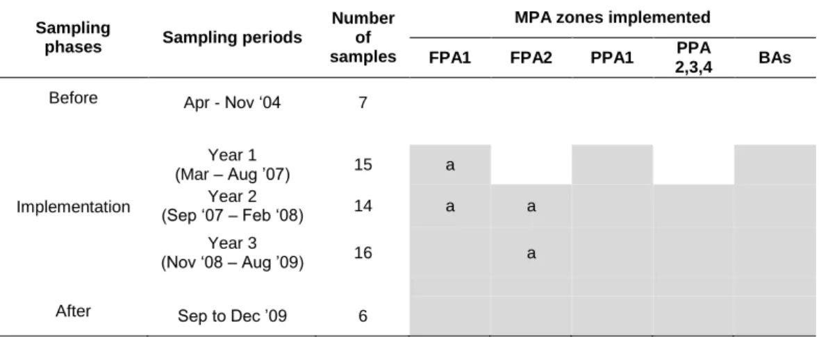
Figure 2.1. Human pressure index values obtained for the study area. The image at the left represents the global results for the study area and figures A to F show in detail the results obtained for Marine Protected Areas. A – Litoral Norte; B – São Jacinto; C - Berlengas; D – Arrábida; E - Santo André and Sancha and F- Southwest Alentejo and Costa Vicentina
In terms of sediment composition, deeper areas of the northwestern and central sectors and most of its southwestern sector are covered by fine and very fine sands. Coarse deposits are found in the inner and middle shelf of the northernmost sector and immediately south of the Nazaré and Setúbal canyons. Extensive mud patches are present in the southern shelf due to its lower energy environment, whilst in the remaining coast they are restricted to areas adjacent to major river mouths (Martins et al., 2012). In mainland Portugal there are six MPA: Litoral Norte, São Jacinto, Berlengas, Arrábida, Santo André and Sancha (hereafter referred as S. André/Sancha) and Sudoeste Alentejano and Costa Vicentina (hereafter referred as SWACV) (Figure 2.1, Table 2.1).
Table 2.1. Marine Protected Areas (MPA) of the study area. Classification status, designation and management plan publication dates, total protected area (km2) and main goals. Dates between
parentheses correspond to alterations in MPA limits.
MPA International designation IUCN Category Designation Management plan publication Total area (km2) Main goals
Litoral Norte Nature Park V 2005 2008 76.5
Protect marine biodiversity;
Sustainable exploitation of marine resources
São Jacinto Nature
Reserve IV 2004 2005 2.5
Protect habitats and associated fauna, flora and landscape Berlengas Nature Reserve World Biosphere Reserve IV 1981 (1998) 2008 95.6 Protect marine biodiversity; Promote sustainable nature tourism and fishing with traditional selective fishing gears
Arrábida Nature Park V 1998 2005 52.9
Protect marine
biodiversity and habitats restoration;
Promote nature tourism and sustainable development of traditional fisheries Santo André and Sancha Nature Reserve IV 2000 (2004) 2007 21.4 Protect marine
biodiversity and improve ecological status of exploited species Sudoeste Alentejano and Costa Vicentina Nature Park V 1995 2011 289.9 Protect marine
biodiversity and improve ecological status of exploited species
Data collection and Human Pressure Index (HPI)
In this study, we used human activities to represent human-derived pressures or stress factors in the marine environment. Due to the complexity and lack of information to precisely classify the impacts of each pressure source in ecosystems, we considered each pressure as having a potentially negative impact on the marine environment. The main human activities occurring along the Portuguese coast, or having direct impact on it, were identified (Table 2.2). Due to the lack of appropriate or quantifiable information, recreational fishing, illegal activities, hand harvesting, dumping and offshore ship traffic were not included in this study though their occurrence along the Portuguese coast is recognized. Expected natural pressures (e.g. ocean acidification, increase in sea temperature) were also not included in the analyses.
The areas and locations of human activities were mapped using ArcGIS 10.1 software. Each activity was mapped in an individual vector layer. All layers were combined to calculate the Human Pressure Index (HPI) in order to account for the differences of scale and features in relation with this study area. HPI calculation and overall methodology were adapted from previous work by (Halpern et al., 2008) and have been previously successfully applied by the authors in a smaller area (Henriques et al., 2014):
where Ai is the intensity of the human pressure at location i and wi is the weight attributed
to that human activity at the same location i. n is the number of human activities considered (n = 18). An HPI value was calculated for each grid parcel (a 500 m grid size was chosen because it represents a good compromise between resolution and information availability) using the module “Environmental Risk Surface (ERS)” of the package “Protected area tools v4” for ArcGIS 10 (Schill and Raber, 2009). Created risk surfaces are therefore raster files with 500 m wide pixels, and each pixel value is the HPI obtained for that location. The range of values obtained represent the relative importance of pressures among grid parcels where the higher HPI value obtained corresponds to the higher pressure level identified in the study area.
n i i iw
A
HPI
1*
Table 2.2. List of threat categories and sub-categories used to calculate the Human Pressure Index (HPI). Metrics, influence distance (m), impact frequency (1−4, where 1 is the lowest frequency), magnitude (1−5, where 1 is the lowest magnitude) and weight (1−3, where 1 is the lowest) for each sub-category are indicated and data sources are presented.
Threat category
Threat sub-category (shapefiles)
Metrics used for intensity categorization Range of influence (m) Impact Frequency Impact magnitude Weight Data Sources
Spatial location categorization Intensity influence Range of
Offshore Aquaculture
Fish and shellfish aquaculture Annual production (kg/km2/year) 1000 4 1 2 Aquaculture companies Aquaculture companies Sarà et al. (2011) and references therein; Forchino et al. (2011) Commercial Fisheries Habitat-destructive -
trawling Hauls per zone 500 3 4 3
VMS data Legislation VMS data (DGRM, 2000-2005) Non-habitat-destructive - purse seines Landings (kg/km2/year) 100 3 2 2 Legislation Interviews Wise (2005, 2007) DGRM (2005-2010) Multi-gear (lines,
nets, traps). Local vessels (Total lenght < 9m) Landings (kg/km2/year) 100 3 3 2 Legislation Interviews Cabral et al. (2007) Batista et al. (2009) Erzini et al. (2003) Santos et al. (2003) Multi-gear (lines,
nets, traps). Coastal vessels (Total
lenght > 9m)
Landings
(kg/km2/year) 100 3 3 2
Subtidal
artificial reefs Artificial reefs Presence/ Absence 1000 4 2 2
Nautical cartography - Ban et al. (2010) and references therein Dredging
activities Dredging deposition
Amount of dredged materials deposited (m3) - from 2000 to 2010 1500 3 3 2 Reports from national ports authorities (IPTM; port administration) Reports from national ports authorities (DGRM; port administration) Ban et al. (2010) and references therein
Table 2.2. (Continued) Threat category Threat sub-category (shapefiles)
Metrics used for intensity categorization Range of influence (m) Impact Frequency Impact magnitude Weight Data Sources Spatial location Intensity
categorization
Range of influence Commercial
port activities Ship traffic
Number of entrances and exits per year per port - 2005-2008 average 1000 4 2 2 Nautical Cartography; areas adjacent to commercial ports National statistics institute (INE, 2005-2008) Ban et al. (2010) and references therein Reacreational activities
SCUBA diving Presence/ Absence 100 3 1 1 Interviews to diving
enterprises; - Ban et al. (2010) and references therein Recreational motor boating Number of anchor places in the adjacent marinas 1000 3 1 1 Interviews to recreational associations; personal observation; national cartography National ports authorities (DGRM , 2010) Ban et al. (2010) and references therein
Marinas Number of anchor
places 1000 4 2 2 Nautical cartography; marina's administration; POEM (2010) National ports authorities (DGRM, 2010) Estimated by authors
Table 2.2. (Continued) Threat category Threat sub-category (shapefiles)
Metrics used for
intensity categorization Range of influence (m) Impact Frequency Impact magnitude Weight Data Sources Spatial location Intensity
categorization Range of influence Pressures from transitional waters Larger estuaries Population, N and P concentrations in the watershed (averaged intensity level) - 2007-2009 30000 4 3 3 National water management authorities (INAG); National Cartography Watershed Management plans (INAG, 2007-2009) Estimated by authors Small estuaries and
coastal lagoons
Ecological quality - as requested for
EU-WFD 2004-2006 2000 4 3 3 INAG (2007-2009) Direct human impact/ Population Benthic structures (pipelines, communication structures)
Presence/ Absence 750 4 1 2 Nautical
Cartography - Estimated by authors Beaches (leisure activities, e.g. swiming, kayaking, kitesurf) Beach typologies (classification from coastal management plans) - 1998-2007 500 3 1 1 National water management authorities (INAG); National Cartography Coastal management plans Coast-line artificialization (peers, docks, harbours and other
constructions) Presence/ Absence 1000 4 1 2 National water management authorities (INAG); National Cartography - Ban et al. (2010) and references therein; DiGiacomo et al. (2004) Sewage (urban nature) Annual sewage discards to the sea
(m3/ year) 5000 4 3 3 National water management authorities (INAG); sewage management entities INAG (2005-2009) Ban et al. (2010) and references therein Industry Industrial infrastructures (I) and thermal plants
(TP)
Annual discards to
the sea (m3/ year) 7500 4
4 - I 2 - TP 3 - I 2 - TP National water management authorities (INAG); INAG (2005-2009) Estimated by authors