PAPER • OPEN ACCESS
Towards Rural Land Use: Challenges for
Oversizing Urban Perimeters in Shrinking Towns
To cite this article: João Sá and Ana Virtudes 2017 IOP Conf. Ser.: Earth Environ. Sci. 95 052016
View the article online for updates and enhancements.
Related content
Theoretical Approaches in the Context of Spatial Planning Decisions and the Relation with Urban Sustainability Kadriye Burcu Yavuz Kumlu and ule Tüde
-Multiscale Spatial Assessment of Determinant Factors of Land Use Change: Study at Urban Area of Yogyakarta Bowo Susilo
-Approach of ICT Application to Governance in Urban Planning Ana Virtudes and João Sá
Towards Rural Land Use: Challenges for Oversizing Urban
Perimeters in Shrinking Towns
João Sá 1, Ana Virtudes 2
1 Department of Civil Engineering and Architecture, University of Beira Interior, 6201-001 Covilhã, Portugal
2 C-MADE, Centre of Materials and Building Technologies, Department of Civil Engineering and Architecture, University of Beira Interior, 6201-001 Covilhã, Portugal
Abstract. This article, based on the literature review, aims to study the challenges of the urban dispersion and oversizing of urban perimeters, in the cases where the towns are shrinking or spreading to the rural land-use. It is focused on the case of Portugal where during the last decades there was an escaping to the big cities alongside to the sea (Atlantic and Mediterranean) shore. In the Interior part of the country, which means near to the border with Spain, several towns are shrinking, despite their huge urban perimeters, proposed by the municipal master plans, since the middle of the nineties. Consequently, these urban perimeters are nowadays oversizing, with empty buildings and non-urbanized areas. At the same time, the social patterns of occupation of this territory have changed significantly, moving from a society with signs of rurality to an urban realm, understood not only in territorial terms but also regarding the current lifestyle. This deep changing has occurred not only in urbanistic terms but also in the economic, cultural and social organizations of the country, under a movement that corresponds to a decline of the small urban settlements in rural areas, far away from the cosmopolitan strip of land nearby the sea, in between the capital city, Lisbon and the second one Oporto. These transformations were not driven by any significant public policy for land-use actions. On the contrary, the production of urban areas, supporting the new model of economic and social development was largely left to the initiative of economic and social private agents and land owners. These agents were the leading responsible for the new urban developments and housing. In this sense, this research aims to present some strategies for the short time period regarding the devolution of urban areas to rural land use. In this sense, the next steps of spatial planning policies, under the role of local authorities (the 308 municipalities including Madeira and Azores islands, plus the continental part of the country), which are their main promoters, will be motivated by the need of advocating the swap of many urban areas towards the rural land use, shrinking many existent urban perimeters in depressed territories. How will the non-urbanized spaces, included in the urban perimeters, twenty years ago, by the pivotal instrument of spatial planning in Portugal, the Municipal Master Plans turn back to the rural land-use, losing their market value? This is the base of the challenges ahead, analysed in this article.
1. Introduction
According to the most recent national statistics (from 2011), there are in Portugal approximately 700.000 empty flats. There are as well, many spaces included as part of the urban perimeters since the middle of the nineties, by the 308 existent municipal master plans, one for each municipality, that in fact, are remaining with rural features. Therefore, many of the planned urban areas for several purposes, such as housing, tertiary activities or industry are still expectant, abandoned or under the
2
Interior regions, considering the towns near to the border with Spain, where there is a process of population decreasing, moving to live in the big cities of the cosmopolitan strip of the sea shore, because of a better job opportunity. Thus, these towns should be object of new spatial planning strategies due to their oversized urban perimeters. This territorial problem become more serious considering the demographic features, showing a stagnation of the population growth or even a decrease in several regions with a low development rate in economic terms.
In this sense, the main conclusion of this article revealed by the literature review, is that the pivotal challenges of spatial planning domain, regarding the referred problem is the combination of policies and strategies, focused on the following aspects: to rethink the traditional and historical city centre, usually very well qualified, and with a great diversity of activities, but still losing inhabitants and increasing the number of empty houses, with the fragmented urban areas, in the peripheral part of the urban perimeters, strongly marked by the rural features.
Much ink has been spilled by many authors analysing the urban perimeters in particular and the cities in general. There is as well, several researches having has the main focus the sprawl of urban areas. However, there is still a lack of scientific approaches having as main topic the shrinking of urban perimeters, based on the existence of huge areas which already remain under the features of rural land use, despite of being officially classified by the spatial planning instruments, has urban territories, for buildings and development purposes.
Having has the main focus the previously referred topic, this article is structure in three parts, which are the following: the features of the urban sprawl process; the role of the spatial planning instruments at the local level regarding the shrinking of urban perimeters in Interior regions; the new models or challenges of the town’s management. All these parts will be analysed, considering the particular background of the Portuguese spatial planning system and its instruments framework. 2. The Portuguese spatial planning system
2.1. The organization of the different spatial planning levels
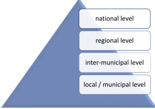
Traditionally, the spatial planning system in Portugal has been organized in the following three levels of acting: The national level, on the behalf of the government and their institutions; the regional level on the behalf of regional authorities, weakened because of the inexistence of regional territories with political autonomy; the local level, which is the strongest on the behalf of the municipalities.
Most recently has emerged a new level of the spatial planning framework which is the inter-municipal, located in between the regional and the local realms, which is not yet very popular, despite of being the only one which is not compulsory, in terms of the elaboration of its instruments (Figure 1). It depends on the voluntary will of the municipalities, to work together in a common purpose, joining their territories in a unique approach, linked strategies and connected goals.
2.2. The framework of the spatial planning instruments
The four referred levels of the Portuguese spatial planning system are comprising a set of several instruments (plans and programmes) (Figure 2). At the national level, there is the national program for spatial planning policy, which is from 2007, having as the main scope the Portuguese territory as a whole, connecting the national goals with the European policies.
At the regional level, there is the regional plan, which is a fragile figure, given that it is not compulsory for the private agents and given that there are no regions in Portugal with political autonomy. There are in the continental part of Portugal, excluding the Madeira and Azores islands which have their special status as autonomous regions, five regions for statistics means (the North including as main city Oporto, the Centre, the Lisbon, the Alentejo and the Algarve, the most south part of the country). Some years ago, a referendum at the national scale to whole population, had has result the ‘no’ to the regionalization. Since then, therefore the figure of the Regional Plan has losing its influence and importance in the spatial planning system.
Figure 1. The levels of the Portuguese spatial planning system
At the inter-municipal scale, there are three figures of plan, the inter-municipal master plan, the inter-municipal urban development plan and the inter-municipal detailed local plan. None of them are compulsory and they depend on the will of the municipalities in working together.
At the local scale, i.e. the municipal level there are as well the figure of the master plan (one for each municipality) having as the main contents the zoning with the building and urbanization rules related to the different types of land use; the urban development plan for the urban areas; and finally, the detailed local plan which is a figure focused on the urban design strategies and projects for the urban areas or for the rural spaces. The detailed local plans have the following three types of figures: the detailed local plan for rural areas, the detailed local plan for urban rehabilitation and the detailed local plan for heritage safeguard purposes.
Figure 2. The spatial planning instruments of the Portuguese system
national level
regional level
inter‐municipal level
local / municipal level
national level
national program for spatial planning policyregional level
regional plan for spatial planninginter‐municipal
level
inter‐municipal master plan inter‐municipal urban development plan inter‐municipal detailed local planmunicipal level
master plan urban development plan detailed local plan4
facilities or the educational facilities, among others. There is also the figure of the special plan which comprises the four types of plans: plans for water reservoirs, plans for natural protected areas, plans for the sea shore and plans for fluvial territories. All of them are under the responsibility of the national authorities.
2.3. The Municipality as the pivotal level and the land uses meanings
The municipal level and its instruments is the pivotal authority of spatial planning in Portugal, including in terms of ordinances which are going to be mandatory considering the building, urbanization and rehabilitation actions. Its importance comes precisely from the fact that is basically under the contents of its three instruments (the master plan, the urban development plan and the detailed local plan) that the processes of building, urbanizing and rehabilitating are going to take place. However, these plans haven’t been enough, during the last 20 years to avoid the oversized urban perimeters, on the contrary. The figure of the Municipal Master Plan has been a great responsible for the promotion of this problem. Although the most recent versions of these plans, in the Interior region of the country, where the population is declining, are considering different strategies, proposing the shrinking of these urban perimeters, transferring urban land uses to the rural condition.
In some cases, there is an uncontrolled dispersion of buildings, a phenomenon that in recent decades has consumed and fragmented spaces formerly intended for agriculture and forestry purposes and for the balance of the ecosystems. The scenario reveals that there is the need of intensify the quality of the methodologies of analysis and monitoring of the urban expansion processes, in order to avoid the existence of urban voids, using all the interior of the urban perimeters, instead of expanding them to new urbanization areas, towards the rural landscape.
Regarding the Portuguese spatial planning rules, there are officially two types of land uses in spatial planning term, that can be proposed by the municipal plans: the urban land use and the rural land use. The urban land use comprises spaces already urbanized, and those where the urbanization is planned and its limit corresponds with the urban perimeter line. The rural land use is related with activities such as agriculture, forest or natural purposes.
Given that nowadays in the Interior regions there is too much urban spaces, corresponding to the oversizing urban perimeters, the procedure of changing one certain area classified as rural land use by the municipal master plan, to the urban land use is a very difficult process. It depends on the confirmation of several aspects such as that there are no urban voids on that perimeter, or that there are no empty buildings in it. Thus, if these situations occur the urban perimeters should be reduced in size, shrinking the urban area, in favour of the rural. This means that part of the previously classified urban spaces is going to turn to rural area. The opposite, an urban area turn to the rural land use is a really easy process.
This process of changing from one type of land use to another occurs under the revision or the elaboration of one municipal plan, which is the way through its contents how this swap takes place. 3. The urban sprawl processes
3.1. Different aspects of the process
The urban sprawl, in its simplest concept, is usually associated with poor or unplanned urban development [1; 2] on the outskirts of the cities. Often it happens at the expenses of the rural land use and it can be considered a dangerous and an unwanted process when the rate of urban expansion exceeds aspects such as the population growth, the needs in terms of housing or the necessities of spaces for economic activities.
The urban sprawl is a complex phenomenon that as has main stage the peripheral areas of the urban settlements. Therefore, the literature reveals that is difficult to define it [2; 3] as a single process, because it has several features considering the different cities. Several terminologies such as suburbanization, are used to define it, referring to the growth of the urban settlements in general or the cities in particular, occupying the territories outside of their previous limits, with people, services, industries and other activities settled down in those new urban areas.
These occupied territories for urban purposes were previously for rural activities, in the majority of the cases. In other situations, the occupied territories could have been previously deserts, such as in the case of many Arabian cities like Dubai in the United Arab Emirates, which in a short period of time was transformed from nearly nothing in terms of urban area, from a little more than a strip of desert into one of the densest and most modern places in the world [4; 5].
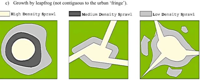
Urban sprawl could be seen as an artificial growth to serve society, opposed to the traditional neighbourhoods, characterized by a mix in terms of urban fabric composition. Sometimes it is characterized by a low profitability, attesting the rural land consumption and the inherent costs and impacts [6], which gives it an adverse connotation. In relation to its spatial distribution, the urban sprawl can present the three distinct patterns [7; 8] listed below (Figure 3):
a) Low density growth contiguous to the urban ‘fringe’; b) Ribbon sprawl;
c) Growth by leapfrog (not contiguous to the urban ‘fringe’).
Figure 3. Some features of the urban sprawl processes: radial sprawl; ribbon sprawl; leapfrog sprawl
According to the same author, the growth of low-density sprawl consumes large areas of land along the outskirts of the cities. In this case, there is a great space between the buildings, in the majority for single-housing, supported by the extension of the urban infrastructures such as the water supply, the power network or the roads. Growth by leapfrog consists of a discontinuous pattern of urbanization, translating into the existence of buildings outside of the city’s boundaries fragmented with non-urbanized places or urban voids, resulting in very low densities below to the density of a contiguous growth. This process is an expensive growth in terms of urban infrastructures [9] because they are dispersing upon large distances. The ribbon sprawl is characterized by an urban growth that appears alongside the road structures, outside the cities.
In addition to these several distinct spatial growth patterns, the urban sprawl can affect the composition of the territory by promoting the segregation of homogeneous areas [10] just for one sort of occupation or activity such as housing, commercial or industrial, among others. Even though the peripheral zones are in many cases associated with a mono activity, and in some situations referring to non-compatible land uses, they should be planned like that, the historical part of the cities is a multi-activities place, marked by the diversity of services, offers, morphological urban elements and people.
3.2. The demographic cause among other reasons
Historically, the growth of cities was a result of a natural process, associated with the growth of their populations. However, at the present, it is clear that the development of modern cities is guided by various economic, social, political and physical factors [11; 12], besides to the demographic issues.
In fact, the phenomenon of suburbanization and its consequent urban dispersion is a process that has occurred since man had the means to travel, to move and to resettle, due to the urban settlements growth needs. Nowadays, this process of proliferation is becoming more diffuse describing negatively the great sprawl on the outskirts of the city.
6
Since the 19 century that, Europe and the United States, and later on the majority of cities all over the world, have witnessed a boom in terms of cities’ growth, especially in an initial phase in London and the major American cities, due to the industrial revolution. As a result, there was an increasing in the prosperity and regarding the access to a cheaper and more accessible means of transportation, which allowed real estate investors to promote new residential areas, which would satisfy the growing process of the middle class. Therefore, there was a strong allocation of housing and population in the peripheries. However, in this urban develop, in some cases the urban growth was substantially higher than the population growth [13; 14]. The later aspect has produced fragmented urban fabrics, very low density urban areas with scarcity of users (inhabitants or non-residents) or urban voids.
The urban growth was a process of a social sphere in which the middle class could be distinguished itself and distant from the working class, limited by the existing means of transport. In Europe, the urban consolidation of cities peaks around 1950-1960, after the World War II. However, during the following decades, the wave of urban growth was increasingly done by the moving away from the city centres, spreading the urban sprawl to the contiguous countryside.
More recently, the areas with the most visible impacts of urban sprawl are in countries or regions with high population densities and economic activities or with a rapid economic growth, which was the case of Portugal after the 1980, due to the benefits coming from funds (structural and cohesion) and regional policies of the European Union. For example, in this country, there was a strong urban growing investment alongside the coastal areas due mainly to the tourism [15].
3.3. The case of Portugal: one country two densities
The Portuguese cities, in particular, has experienced one of the largest urban growth in the European Union, mainly associated with the two metropolitan areas of Lisbon and Oporto, the Algarve coastal zone and the coastal corridors such as Lisbon/Setúbal, or Oporto/Viana do Castelo (Figure 4).
Usually in an approach related with the topic urban / rural considering the countries as a whole, the differences in density terms are mainly between the urban centres with higher rates of densities (including people, buildings, activities or opportunities) and the rural landscape, with lower levels of all these parameters. However, in Portugal these differences are as well based on the gap in between the Interior regions in decline and the coastal strip of land where the majority of the activities, industries, population, services, infrastructures or offers in the domains of cultural, education or healthcare services is concentrated. In a country with about 10 million in terms of population, one third is leaving in Lisbon metropolitan area, nearly 2 million in the Oporto metropolitan region and the Algarve rates about 500.000 inhabitants.
This duality in between the high density of the coastal area and the low density of the Interior has had as a features the migration of people from the rural Interior labor to the industrial sector near to the sea shore, which was reflected in the urban expansion of the coastal cities, resulting in the so-called process of ‘littoralization” of the country.
This process is not new, and has its roots in the great intensity of the urbanization sprawl, coming from the 1960, accompanied by the development of the secondary sector [16]. At the same time, the Algarve was under an intense urban pressure induced by the boom of the touristic activity. This increment was leading to a growth of the urban areas at the expenses of the agricultural territory, associated with ‘agro-ecological’ land uses and natural-cultural conditions, under a process of lack of spatial planning rules, becoming uncontrolled [17], to the detriment of the quality of the spaces.
Only after the 1990, the spatial planning rules started to be created, throughout the figure of the Municipal Master Plan, in order to put an order on this legacy, qualifying not only the urban settlements but also the sea shore, including the protected areas for natural and cultural purposes. 4. The urban expansion under a generation of planned territories
In the 1990, the generation of municipal master plans, led to an urban management on the behalf of local authorities, the municipalities. The local authorities had the main role of the spatial planning process in the country, based on the contents of the municipal master plan. If its role was pivotal regarding the creation of the ordinance rules through the figure of the master plan, in terms of
execution of its contents, the role of the local authorities was less efficient. In fact, the private sector was the main responsible for the urbanization process and therefore for the urban sprawl.
Figure 4. Duality between the high density of the coastal strip of land (in between Lisbon and Oporto) and the Interior near to the border with Spain.
The municipalities have several difficulties in controlling the urban sprawl process, being under the initiative of the private stakeholders. This Hera is no more a time of promotion of social housing,
8
in the cities centres.
Despite that all the Portuguese territory is covered by the contents, the buildings and urbanization rules, of the municipal master plans, having no piece of land in this country, without spatial planning rules, the fact is that this plan is exactly a master plan for the municipal territory as a whole. Its main content is the mapping of the different land-uses; identifying the urban spaces vs. the rural areas; and the definition of their ordinances in terms of spatial planning domain. Therefore, this plan is not focused on the interior or the inside of the urban perimeters. It is not focused on the urban design nor the urban rehabilitation proposals. Its scale is usually (depending on the size of the municipality) 1:25000, which means that there is a lack of room to rethink the inside of urban perimeters. The latter is a task for the urban development plans, considering the urban settlement as a whole, using as working scale 1:1000 or for the detailed local plan, which is the spatial planning figure designed to be expert in urban design and rehabilitation strategies, using the scale of 1:2000.
The next generation of spatial planning in Portugal, regarding the rehabilitation of the cities, is the generation of the detailed local plans and the urban design. In fact, in many cases this policy is already a reality, under the existence of special budgets, involving funds from the European Union, from national authorities and from the local agents, public and private.
In a scenario of decreasing of their population or in an optimistic view of stagnation of the number of their inhabitants, the cities of the Interior should follow a path of requalification, rehabilitation of the existent urban areas, in order to provide better conditions for those who are living there.
5. Conclusions
As this article aimed to show, the urban sprawl is not a homogenous process with the same features in all cities. It depends on many aspects such as the cities characteristics or their dynamics in demographic, economic, social or territorial terms.
In Portugal, there is duality in between the cities and the territories of the sea shore, especially in the regions of Lisbon, Oporto and Algarve, and the all Interior part, far away from the Atlantic and from the Mediterranean coastal zone. The first has a high level of population, urban density, diversity and economic opportunities, being regions of success. The second has a decrease of population, economic opportunities and a lack of spatial planning policies for the conservation and protection of rural areas. In fact, the main figure of the spatial planning framework in Portugal is the municipal master plan. However, this figure has not been sufficient to take care of the rural spaces, being focused on the urban perimeters. Although this focus was not enough to avoid the existence of urban voids and the referred disadvantages of an uncontrolled urban sprawl.
The next steps should be focused on how to rethink the oversized urban perimeters in the Interior regions, towards the qualification of the rural areas. The rural land use can’t be seen anymore as the negative image of the urban spaces, which means as a kind of non-urban space, but should be seen as a rural territory with needs of particular spatial planning solutions, strategies and proposals. In this sense, there is still a huge path ahead, of planning the rural areas by what they are (reinforcing the good features), by what they should be (promoting new approaches) and by what they can’t continuing to be (stopping the bad features).
Acknowledgements
This work is supported with Portuguese national funds by FCT - Foundation for Science and Technology within the UID/ECI/04082/2013 project.
References
[1] Sierra Club, (2001), “Stop Sprawl: New research on population, suburban sprawl, and smart growth”, Sierra Club, San Francisco, available in: http://vault.sierraclub.org/sprawl/overview/.
[2] Ewing, R., Pendal, R., Chen, D. (2002), “Measuring Sprawl and Its Impact”, Smart Growth
America, Washington, DC, available in:
https://www.smartgrowthamerica.org/app/legacy/documents/MeasuringSprawl.pdf.
concept”, Housing Policy Debate, Fannie Mae Foundation, Vol. 12, Issue 4, pp 681-717. [4] Abbara, A. (2017) “Smart Cities in Arabian Cultures: Dubai as a case study”, Master Degree
Dissertation in Civil Engineering, University of Beira Interior, Portugal.
[5] Virtudes, A., Abbara, A., Sá, J., Dubai: a pioneer smart city in the Arabian territory, in World Multidisciplinary Civil Engineering-Architecture-Urban Planning Symposium, WMCAUS 2017, Prague (Czech Republic) 12-16 June 2017.
[6] Johnson, M. P. (2001), “Environmental impacts of urban sprawl: A survey of the literature and proposed research agenda”, Environment and Planning A, Vol. 33, pp 717-735.
[7] Duany, A., Plater-Zyberk, E., Spech, J. (2001), “suburban Nation: The Rise of Sprawl and the Decline of the American Dream”, North Point Press, New York, 10th Anniversary Paperback ISBN: 978-0-86547-750-6.
[8] Downs, A. (1998), “How America’s cities are growing: the big picture”, Brookings Review, Vol. 16, No. 4 (Fall), pp 8-11.
[9] Rocha, J., Tenedório, J., Sousa, P. M., Costa, E. M., Costa, N. M. (2005), “Characterization of the Urban-Rural fringe through the gradient: analysis by continuum vs. contrast” (in
Portuguese), available in:
http://www.apgeo.pt/files/docs/CD_X_Coloquio_Iberico_Geografia/pdfs/097.pdf.
[10] Ewing, R. (1994), “Characteristics, causes, and effects of sprawl: a literature review”, Urban Ecology. Springer, Boston, MA, Vol. 21, pp 1-15, Online ISBN: 978-0-387-73412-5. [11] Kaiser, E. J., Weiss, S. F. (1970), “Public policy and the residential development process”,
Journal of the American Planning Association, 1939-0130, Vol. 36, Issue 1, pp 30-37. [12] Pendall, R. (1999), “Do Land Use Controls Cause Sprawl?”, Environmental and Planning B:
Planning and Design, Vol. 26, pp 555-571.
[13] Bruegmann, R. (2005), “Sprawl: A Compact History”, The University of Chicago Press, Chicago, DC, ISBN: 0226076911, 9780226076911.
[14] VTPI (2016), “Automobile Dependency - Transportation and Land Use Patterns That Cause High Levels of Automobile Use and Reduced Transport Option”s, TDM Encyclopedia, Victoria Transport Policy Institute, available in: http://www.vtpi.org/tdm/tdm100.htm. [15] EEA (2006), “Urban sprawl in Europe – The ignored challenge”, Report N.º 10, European
Environment Agency, Copenhagen, ISBN: 92-9167-887-2.
[16] Marques, T. S., Silva, F. B., Delgado, C. (2009), “The building occupation: delimitation of areas of homogenous density” (in Portuguese), Department of Geography, FLUP / CEGOT, available in: https://repositorio-aberto.up.pt/bitstream/10216/19849/2/000082757.pdf. [17] Mattoso, J., Belo, D., Daveau, S. (1997), “Portugal-The taste of the Land” (in Portuguese),