Index Terms— Multi-criteria decision making, fuzzy, analytic network process, soil erosion
Abstract—The aim of the present study is to evaluate the methods for preventing soil erosion through fuzzy ANP. The problem was considered as a multi-criteria decision making problem. Among the main criteria taken into account in this paper, some are climate, topography, soil, land use, and human activities. This paper also includes some sub-criteria because of the hierarchical structure of the problem. Then, the problem was applied to Turkey and solved by using fuzzy ANP and the methods for preventing soil erosion were evaluated.
I. INTRODUCTION
OIL erosion, for its negative effects on sustainable agriculture and environmental protection, is a threat to many areas in Turkey. Reliable information is needed for the solution of this problem and for the precautions about effective soil conservation [1]. It is asserted on assessing all data that are actual to solve the problem formed with a complex causal relation. The best way to predict the effects of the erosion processes is to formulate the available information with diagrams, equalities, etc. The valid opinion for this formulation is to solve by creating models, which is getting more complex and becoming dependent on computers.
The success of the mathematical model is evaluated by its applicability and its proximity of the predicted erosion rate with the real data. However, no model has yet achieved the certainty to meet these expectations without any argument. Integrated research groups and interdisciplinary studies are required for this matter [2], [3]. With the developing technology, it is understood that existing models are far from anticipating erosion correctly. Also most of the existing models require variables impractical to be provided. This bears the necessity of new approaches in erosion modeling.
To satisfy this necessity, multi-criteria decision making
Manuscript received March 4, 2011; revised March 22, 2011. Tufan Demirel is with the Yildiz Technical University, Department of Industrial Engineering, Yildiz Technical University, Besiktas, 34349 Istanbul, Turkey (corresponding author to provide phone: +90 212 383 2867; fax: +90 212 258 59 28; e-mail: [email protected]).
Serhat Tüzün is with the Yildiz Technical University, Department of Industrial Engineering, Yildiz Technical University, Besiktas, 34349 Istanbul, Turkey (e-mail: [email protected]).
methods are proposed as innovative approach [4]. And to avoid the problem of transforming improportionate data to a numerical scale, MCDM methods have been combined with fuzzy logic [5], [6].
The objective of the present study is to evaluate the alternatives for preventing soil erosion through fuzzy Analytic Network Process (ANP).
II. SOIL EROSION IN TURKEY
Turkey is experiencing high soil erosion. TEMA had prepared a report showing the density and the increasing rate of erosion in Turkey in order to attract attention to the importance of the matter [7]:
The main reasons of erosion in Turkey are topographic structure, climate, incorrect agricultural practices, and overuse of land and soil type.
One of the topographic features that influence erosion is slope. On steep or longer slopes, erosion rates will increase. In Turkey, only 8.5% (6.584.600 ha) of the total land has less than 8% slope steepness. About 12.8% and 16.2% of the land has the slope steepness of 5-10% and % 10-15, respectively, while the rest of the land (62.5%) has more than 15% slope steepness. Besides, the average altitude from the sea level for Turkey is 1132 m, which is about 800 m higher than the average altitude in Europe [8].
The major climatic factors affecting erosion include temperature, rainfall and wind. The effects of these factors become more evident on evaporation and transpiration processes. These processes reduce soil water content and subsequently decrease runoff and surface erosion.
Multi Criteria Evaluation of the Methods for
Preventing Soil Erosion Using Fuzzy ANP: The
Case of Turkey
Tufan Demirel, and Serhat Tüzün
S
TABLEIEROSION RATES IN TURKEY
Erosion Level Land Covered (in Hectare) %
0 (None) 5.166.627 6,64
1 (Weak) 5.611.892 7,22
2 (Fair) 15.592.750 20,04 3 (Severe) 28.334.933 36,42 4 (Too Severe) 17.366.463 22,32 W (Wind Erosion) 506.309 0,65 BC (Bare Cliff) 2.930.933 3,77
79
,4
Topographical structure over the land of Turkey varies in different geographical regions. For example, mountains lie parallel to the sea shores in Blacksea and Mediterranean Regions, while they are perpendicular to the sea shores in Aegean Region. Therefore, the precipitation intensity also varies in these regions. For example, Konya in Central Anatolia Region receives the average annual precipitation of 278 mm, while Rize in Blacksea Region receives the average annual precipitation of 2696 mm.
Erosion effects are more clearly seen on the coastal regions of Turkey, due to high precipitation amounts in these regions [9].
Plant cover plays a major role in reducing erosion. During the last 30-40 years, a significant portion of the world’s forest cover was removed by human activities. In Turkey, deforestation due to human activities is even more catastrophic. Today, only 27% of the country is covered by forest (21.18 million/ha) and about half of this area is subject to reforestation and erosion control studies [10].
About 34% of the land is used for agricultural production in Turkey. Agricultural lands are mostly susceptible to erosion since they are generally located in steep sloped, infertile, and shallow lands. In a 2006 report commissioned by the UN, Turkish officials declared that “of all human activities, agricultural production has had the greatest impact on soil degradation” [11]. Besides, the rangeland areas, which are important for soil conservation, are converted into agricultural lands in last 5 decades. Today, about 27% of the land is covered by rangelands. In Turkey, rangeland vegetation has been degraded because of heavy and unsuitable grazing. Having lack of effective rangeland areas directed grazing activities into the forest lands. Therefore, improper land use is also one of the main erosion factors in Turkey.
Soil erodibility characterizes erosion tendency, depending
on varied properties of soil. Although active erosion is not observed on soils under dense and protective vegetation cover, the erodibility indexes might be high in those kinds of soils due to geological structure. Especially, neogen, plio-quarterner, volcanic sand, cretase and eosene structure, and tufa, which cover large areas in Turkey, are susceptible to the erosion. Removing protective cover of such soils may cause even more erosion if topographic and precipitation conditions are suitable.
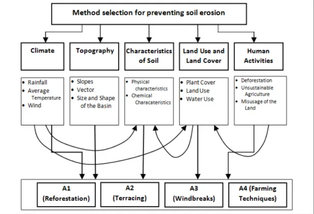
III. SELECTION CRITERIA FOR PREVENTING SOIL EROSION The model has been built by taking the reasons of soil erosion as criteria. Experts’ views and the studies on this matter were referenced in determining main and sub-criteria[7], [11]. These main and their sub-criteria are;
Climate: Climatic factors; rain, temperature and wind have effects on erosion.
Rainfall: Duration and density of the rain directly affects the erosion. As the rainfall increases, erosion rate increases.
Average Temperature: A high temperature increases fragmentation of organic substances, which will result in a decrease in the plant cover and increase in the erosion rate.
Wind: The rate of erosion depends on wind speed and storm frequency in the area.
Topography: Topography is one the main factors affecting erosion. It has the following sub-criteria:
Slope: The erosion rate changes due to the length, steepness and the shape of the slope.
Vector: Direction of the terrain indirectly affects temperature, which leads to a change in the erosion rate.
Size and shape of the basin: Erosion and the size of the basin are directly proportional. Apart from the size, shape of the basin is also important in terms of erosion.
Characteristics of Soil: Type of soil may have negative or positive effects on erosion. It is divided into two:
Physical characteristics: The proportion of sand, clay and
other materials; capacity of water retention; aggregation and permeability of air and water form the physical characteristics of soil.
Chemical characteristics: Calcium carbonate in soil and the organic substances form the chemical characteristics and have effects on erosion.
Land Use and Land Cover: The surface of the land has a layer that protects from erosion. As this layer weakens, the risk of erosion increases. The following factors are determined as the sub-criteria:
Plant Cover: This factor is about which plant the land is covered with; it can be a permanent flora such as forest or an agricultural plant.
Land Use: It is about how and what the land is used for. It can be a dense agricultural usage, which can harm the flora and the soil.
Water Use: Water use is an important factor on erosion. It has to be under control in order to protect the land from erosion risk.
Human Activities: It is the most important criterion since it does not only have a direct effect on erosion, it also affects the other factors. The sub-criteria are:
Deforestation: Destroying the land cover by logging, heavy grazing, slash and burn of the forests, etc. will lead to increased erosion.
Unsustainable Agriculture: Using wrong farming techniques and insensible agriculture will degrade the soil and result in a higher erosion rate.
Misusage of the land: Using the land apart from its
purpose and not considering the land’s features before usage may result in causing increased rates of erosion because of the removed ground cover.
The alternatives to be compared considering the criteria above are the following precautions and improvement operations selected in order to prevent soil erosion:
Reforestation, Terracing, Building windbreaks, Applying suitable and correct farming techniques.
IV. MULTI-CRITERIA DECISION MAKING
The Analytical Network Process is the generalization of Saaty’s Analytical Hierarchy Process, which is one of the most widely employed decision support tools [12]. Similarly to the AHP, the priorities in the ANP are assessed indirectly from pair-wise comparisons judgments [13]. In the ANP method, decision makers can meet uncertainty and mean multiplicities when they are selecting the best one through the possible alternatives. Furthermore, uncertainty always exists in the human world and estimations about qualitative attributes that have done by people are always subjective. Fuzzy ANP can be viewed as an extension of ANP to accommodate explicitly the fuzziness in the evaluation process. It could adequately handle the judgments derived from perception-based information which are intrinsically imprecise, reflecting the bounded ability of human mind to resolve detail and store information [14].
In the literature, Fuzzy ANP method has been used to solve problems like Research and Development Project Selection [15], Performance Evaluation [16], Quality Function Deployment Implementation [17], Enterprise Resource Planning (ERP) Software Selection [18], Evaluation of Land Cover Policies [19].
In this study, the methods for preventing soil erosion are evaluated using Promentilla et al’s [14] fuzzy ANP method. In this paper, the computational procedure of using multi-criteria decision making methodology is summarized as follows [14]:
Step 1: Decompose the multiple criteria evaluation
problem into a strongly connected hierarchical network.
Step 2: Elicit value judgments from DM to compare each pair of elements with respect to an element. Then, construct the fuzzy pairwise comparison matrix such that:
(1)
where
a
ˆ
ij≥
1
anda
ˆ
ij=
1
/
a
ˆ
ij.Step 3: Solve the fuzzy eigenvalue problem.
w w
Aˆˆ =λˆˆ (2)
where Aˆ is and nxn fuzzy matrix containing fuzzy numbers ij
aˆ and wˆ is a positive nx1 fuzzy vector containing fuzzy numbers.
Step 4: Assign an optimism λ index value. The optimism index is a linear convex combination defined as
(3)
Step 5: With α fixed, construct the following matrix after setting the λ parameters:
(4)
Step 6: From Eq. (4), calculate the local priorities or the
normalized principal right eigenvector for all α-cut values [0,1] at a given fixed λ value. Computational wise, the principal right eigenvector can be approximated from the following equation [20]:
w c e A e e A k T k
k ˆ ˆ
ˆ
lim =
∞
→ (5) where eT=[1, 1, ..., 1] is a unit row vector, c is a constant and
wˆ is the eigenvector corresponding to the principal eigenvalue of the primitive matrix Aˆ .
Step 7: Compute the overall priorities from principal column eigenvector of the initial supermatrix of the hierarchical network.
Step 8: Repeat calculations from Steps 4 to 7 to derive the
set of desired priorities for all α-cut at different λ values
= 1 ˆ ˆ ˆ 1 ˆ ˆ ˆ 1 ˆ 2 1 2 21 1 12 n n n n a a a a a a A
(
1
)
,
[ ]
0
,
1
.
ˆ
ijα=
−
λ
a
ijlα+
λ
a
αiju∀
λ
∈
V. AN APPLICATION IN TURKEY
The problem discussed here is about evaluating the alternatives for preventing soil erosion in Turkey. Hierarchy network that is established in section 3 is determined from its main and sub criteria by TEMA’s report [7] and the experts who are involved with this state.
After the network has been established, fuzzy comparison matrices are formed. The data used in the matrices are obtained from experts’ views, previous studies and reports. Then, these data has been transformed into fuzzy values with the δ value of 1. Fuzzy comparison matrix of the criteria respect to goal can be seen in figure 2. All of the fuzzy comparison matrices are formed like in figure 2.
The next step is the defuzzification process. Fuzzy values obtained from the pairwise comparisons are defuzzified using λ and α-cut values. Defuzzified values of the matrix given in figure 2 with a λ value of 1 and α-cut value of 0.5 are as follows (Fig. 3):
When all of the defuzzified values are calculated for the selected λ and α-cut values, these values are brought together to form the unweighted supermatrix. Then, the weights of the criteria are put to use to calculate the weighted supermatrix. Last, the limit matrix is calculated using the formula given in step 6 in the previous section.
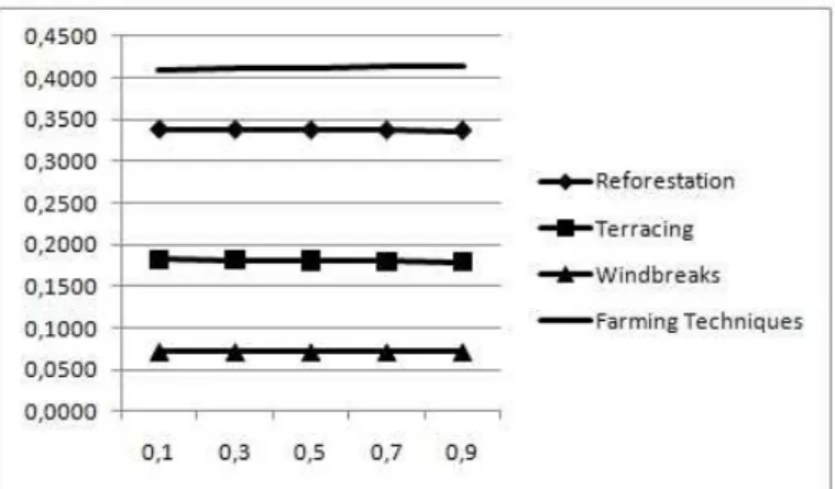
The computations have been made for different λand α -cut values and the results are obtained as follows (Fig. 4, Fig. 5, and Fig. 6):
We calculate the overall performance index for each alternative location by letting α= 0.1, 0.3, 0.5, 0.7, 0.9, and
λ= 0.0 (for a pessimistic DM), λ=0.5 (for a moderate DM) and λ=1.0 (for an optimistic DM) and determine its
corresponding ranking. The results in the figures show that “Farming techniques” is clearly the best choice under almost any degree of confidence of a pessimistic, moderate or optimistic decision maker.
VI. CONCLUSION
In the present study, after main and sub-criteria were determined, the most suitable solution among alternatives for preventing soil erosion in Turkey was determined by using fuzzy ANP method. In this methodology, the use of optimism index allows to reflect the DM’s attitude towards the fuzziness of judgment.
The results show us that, farming techniques and reforestation are vital methods for the solution of the problem. TEMA’s report [7] states that reforestation has been put into practice, even if it is not still in the desired level. Unfortunately there has been no work or study done for the farming techniques to offer solution to Turkey’s soil erosion problem.
So for the future research, farming techniques should be investigated in detail and their effects over human activities, the main reason of the soil erosion in Turkey should be evaluated.
Fig. 4. Performance index and ranking of the alternatives for a moderate decision maker.
Fig. 5. Performance index and ranking of the alternatives for a pessimistic decision maker.
Fig. 6. Performance index and ranking of the alternatives for an optimistic decision maker.
Climate Topography Soil Land Use Human
Climate 1.000 3.500 0.400 0.400 0.222
Topography 0.400 1.000 0.400 0.222 0.154
Soil 3.500 3.500 1.000 0.222 0.400
Land Use 3.500 5.500 5.500 1.000 0.400
Human 5.500 7.500 3.500 3.500 1.000
Fig. 3. Defuzzified values of the criteria respect to goal.
Climate 1.001.001.00 2.003.004.00 0.250.330.50 0.250.330.50 0.170.200.25
Topography0.250.330.50 1.001.001.00 0.250.330.50 0.170.200.25 0.130.140.17
Soil 2.003.004.00 2.003.004.00 1.001.001.00 0.170.200.25 0.250.330.50
Land Use 2.003.004.00 4.005.006.00 4.005.006.00 1.001.001.00 0.250.330.50
Human 4.005.006.00 6.007.008.00 2.003.004.00 2.003.004.00 1.001.001.00
Climate Topography Soil Land Human
REFERENCES
[1] S. Hacıyakupoğlu and T. A. Ertek, “Usage of Cs-137 and Pb-210 measurements in erosion research and the feasibility in Turkey (Erozyon araştırmalarında Cs-137 ve Pb-210 ölçümlerinin
kullanılması ve Türkiye’de uygulanabilirliği),” Protection,
Improvement and Management of Soil and Water Resources at the Water Basins Symposium, Antakya, Turkey, Sept. 18-20, 2002, 396-401.
[2] S. Hacısalihoğlu, H. Z. Kalay and E. Oktan, “Evaluation of the
models determining the soil degradation quantitatively (Toprak aşınımını kantitatif olarak belirleyen modellerin değerlendirilmesi),” Protection, Improvement and Management of Soil and Water Resources at the Water Basins Symposium, Antakya, Turkey, Sept. 18-20, 2002, 379-384.
[3] N. Özdemir, Soil and Water Protection (Toprak ve Su Koruma), Samsun, 2002.
[4] T. Rehman and C. Romero, "The application of the MCDM paradigm to the management of agricultural systems: Some basic considerations, " Agricultural Systems vol. 41, special issue, pp. 239-255, 1993.
[5] L.A. Marks, E.G. Dunn, J.M. Keller and L.D. Godsey, “Multiple Criteria Decision Making (MCDM) Using Fuzzy Logic: An Innovative Approach to Sustainable Agriculture”, IEEE Proceedings of ISUMA-NAFIPS, 1995.
[6] T. Yakupoğlu, N. Özdemir and I. Ekberli, “Fuzzy Logic Applications in Soil Erosion Studies (Toprak Erozyonu Çalışmalarında Bulanık
Mantık Uygulamaları),” J. Of Fac. Of Agric., 23(2), pp. 121-130,
2008.
[7] T. Günay, Forest Deforestation Soil Erosion (Orman Ormansızlaşma Toprak Erozyon), İstanbul: TEMA,1997, pp 85 – 123.
[8] O. Erdaş and A. Yüksel, 1999, “Factors of soil erosion in our country and at K.Maraş and their effects over the environment (Ülkemizde ve K.Maraş Yöresinde Erozyon Oluşumuna Neden Olan Faktörler ve
Bunların Çevreye Olan Etkilerinin Değerlendirilmesi),” City
Management Human and Environment Symposium, Istanbul, Turkey, Febr. 17-19, 1999, pp. 294-303.
[9] O. Doğan, “Mudslides in Turkey, Problems and Solutions
(Türkiye’de Toprak Kaymaları, Sorunlar ve Çözümler),” Standard Journal (Standart Dergisi), May 1995, pp. 73-79, 1995.
[10] Our Forest Properties (Orman Varlığımız), Publications of the Ministry of Environment and Forest), Ankara, Turkey, 2006. [11] A. Gobin, J. Daroussin and R. Jones. (2003, Sept. 30). Pan-European
Soil Erosion Risk Assessment (Deliverable 17) [Online]. Available:
[12] M.A.B.Promentilla, Furuichi T, Ishii K, et al. “Evaluation of remedial countermeasures using the analytic network process”, Waste Manage 26, 2006, 1410-21.
[13] L.Mikhailov and Singh MG. “ Fuzzy analytic network process and its application to the development of decision support systems”, IEEE Transaction on Systems, Man, and Cybernetics-Part C: Applications and Reviews, 33, 1, 2003, 33-41.
[14] M. A. B. Promentilla, T. Furuichi, K. Ishii and N. Tanikawa, “A fuzzy analytic network process for multi-criteria evaluation of contaminated site remedial countermeasures,” Journal of Environmental Management, 88, 479-495, 2008.
[15] R.P.Mohanty, Agarwal R, Choudhury AK, et al., “A Fuzzy ANP– based approach to R&D project selection: A case study”, International Journal of Production Research, 43,24,5199-216, 2005.
[16] S.Yellepeddi, An Analytical Network Process (ANP) Approach for the Development of a Reverse Supply Chain Performance Index in Consumer Electronics Industry, PhD Dissertation, The University of Texas at Arlington, Arlington, TX, USA, 2006
[17] T.Ertay T, G.Büyüközkan, C. Kahraman, et al. ”Quality function deployment implementation based on Analytic Network Process with linguistic data: An application in automotive industry”, Journal of Intelligent & Fuzzy Systems 16, 221-32, 2005.
[18] Z.Ayag and R.G.Ozdemir RG. “An intelligent approach to ERP software selection through fuzzy ANP”, Internat J Production Res 45(10,:2169-94, 2007.
[19] T. Demirel, H. Muşdal, N. C. Demirel and G. N. Yücenur, “Multi-Criteria Evaluation of Land Cover Policies Using Fuzzy AHP and Fuzzy ANP: The Case of Turkey”, Journal of Human and Ecological Risk Assessment, Vol 15, No 4, 746-764, 2009.