online | memorias.ioc.fiocruz.br The transmission of kala-azar, or visceral
leishmania-sis (VL), is strongly influenced by the available moisture, medium to high temperatures and high relative humidity (RH) because the sandfly, Phlebotomus argentipes, re-quires damp surfaces and humid atmospheric conditions for prolonged survival, which is needed to transmit the infection (Bhunia et al. 2010a, Picado et al. 2010, WHO 2010a). Few studies have demonstrated the usefulness of remote sensing data in mapping the environmental risk factors, including diurnal temperature variations, eco-environments, vegetation health and land use practices, that control, in part, the distribution of tropical diseases, including leishmaniasis, schistosomiasis, trypanosomia-sis and malaria (Robinson et al. 2002, Graves et al. 2009, Bhunia et al. 2012).
Using remote sensing to identify the biophysical and environmental variables that are adequate for the development of various infectious diseases (Beck et al. 1994, Gillies & Carlson 1995, Kustas & Norman 1996, Gillies et al. 1997, Combie et al. 1999, Oscar & Ma-lone 2001), allows for the determination of risk factors and the delimitation of areas at risk, thereby enabling a more rational allocation of resources for cost-effective control (Beck et al. 1997, 2000, Bhunia et al. 2010b).
Such environmental features may be used to appraise favourable environments for the development of vec-tors implicated in disease transmission (Werneck et al. 2002, Lindgren et al. 2004).
The land surface temperature (LST) and the renor-malised difference vegetation indices (RDVI) were the two parameters used in the present study of a kala-azar focus in Bihar, India (Fig. 1). Temperature affects ka-la-azar transmission in two ways: either the minimum temperature may be so low that it prevents parasite and vector development or the temperature may be too high, resulting in the increased mortality of the vector. A monthly mean maximum temperature of < 37ºC and a monthlymean minimum temperature of > 7.2ºC are favourable ecologic factors forthe transmission of kala-azar (Napier 1926). Temperature is an important factor when determining the distribution of the sandfly, previ-ous research showed that regions with temperatures that drop to 7ºC are rarely at risk for kala-azar epidemics and can be disregarded. Temperature can be measured at ground stations or using satellite instruments, that have the ability to measure the land surface temperature; such measurement ability is an important advantage when meteorological stations are non-existent. The products derived from the LANDSAT-5 Thematic Mapper (TM) of 2009 and 2010 were applied to calculate the available LST and RDVI for the peak and lean seasons of sand-flies. These are considered to be environmental risk fac-tors for infection with kala-azar in India. For example, in a previous study by Gebre-Michael et al. (2004) in East Africa, Advanced Very High Resolution Radiom-eter (AVHRR) satellite data were used to map the oc-currence of Phlebotomus orientalis and Phlebotomus (Synphlebotomus) martini,which were best predicted by Financial support: ICMR Senior Research Fellowship
SK and GSB contributed equally for this work. + Corresponding author: drpradeep.das@gmail.com Received 11 June 2012
Accepted 12 November 2012
Appraisal of Phlebotomus argentipes habitat suitability using
a remotely sensed index in the kala-azar endemic focus of Bihar, India
Shreekant Kesari1, Gouri Sankar Bhunia1, Nandini Chatterjee2,
Vijay Kumar1, Rakesh Mandal1, Pradeep Das1/+
1Department of Vector Biology and Control, Rajendra Memorial Research Institute of Medical Sciences, Indian Council of
Medical Research, Agamkuan, Bihar, India 2Department of Geography, Presidency University, Kolkata, West Bengal, India
Visceral leishmaniasis, or kala-azar, is recognised as a serious emerging public health problem in India. In this study, environmental parameters, such as land surface temperature (LST) and renormalised difference veg-etation indices (RDVI), were used to delineate the association between environmental variables and Phlebotomus argentipes abundance in a representative endemic region of Bihar, India. The adult P. argentipes were collected between September 2009-February 2010 using the hand-held aspirator technique. The distribution of P. argentipes was analysed with the LST and RDVI of the peak and lean seasons. The association between environmental covariates and P. argentipes density was analysed a multivariate linear regression model. The sandfly density at its maximum in September, whereas the minimum density was recorded in January. The regression model indicated that the season, minimum LST, mean LST and mean RDVI were the best environmental covariates for the P. argentipes distribution. The final model indicated that nearly 74% of the variance of sandfly density could be explained by these environmen-tal covariates. This approach might be useful for mapping and predicting the distribution of P. argentipes, which may help the health agencies that are involved in the kala-azar control programme focus on high-risk areas.
the wet and dry season models, respectively, based on remotely sensed variables, normalised differential veg-etation indices (NDVI) and LST. That study, however, was limited by the coarse spatial resolution (1 km resolu-tion at the nadir) of the AVHRR sensor.
The present study examines the usefulness of envi-ronmental parameters, such as the LST and the RDVI, to assess the association with the abundance of the vector P. argentipes to develop local maps of risk and map the kala-azar transmission in endemic areas of the Indian sub-continent.
MATERIALS AND METHODS
Study area - The district of Muzaffarpur was select-ed as a representative region of endemic focus in Bihar. It lies between north latitudes 25º54’00”-26º23’00” and east longitudes 84º53’00”-85º45’00”. The total popula-tion of the district is 4,778,610 with a density of 1,506 persons per km2; based on the 2011 census, the district had a decennial growth of 27.54% (census2011.co.in/cen-sus/district-/68-muzaffarpur.html). All 14 public health centres within the district are affected by this disease (Fig. 1). The drainage system of the area originates from the Himalayas and converges into the major rivers of the district, which are primarily drained by the rivers Burhi Gandak, Baghmati and Baya, which generally flow in the south-easterly direction. The district experiences a severe winter followed by a very hot summer (44ºC) and then a heavy monsoon downpour. The district receives an average rainfall of 1,280 mm (muzaffarpur.bih.nic. in/) and has an average elevation of 47 m. The soil of the entire district is highly fertile, well drained and sandy, white coloured and very soft. The annual recharge of ground water bodies constitutes a replenishable or
dy-namic resource (cgwb.gov.in/District_Profile/Bihar/ Muzaffarpur.pdf).
Sandfly collection - Adult sandflies were collected between September 2009-February 2010 within the study area. The identification of houses for the sandfly collection was performed in two steps. First, 51 villages were randomly selected within the districts based on high cases incidence data (an average incidence rate of more than 10/10,000 population in the last three consec-utive years (2006-2009) and in each village, 10 house-holds were selected randomly at the centre of the village, for the sandfly collection (Fig. 1). The sandfly collection was performed separately in each season for the same villages and at similar collection sites. To determine the sandfly density, flies were collected for 10 min from two indoor (i.e., living room and cattle shed) resting places; this collection was performed by trained field workers, using the hand-held aspirator technique with three-celled torches (Kumar et al. 2009, WHO 2010b). The sandfly collection was performed at dawn and dusk. The col-lected sandflies were stored in 70% ethanol in vials that were labelled with the area, village name and number of sandflies caught. All species were mounted on mi-cro slides using Canada balsam, as a measuring media (Remaudière 1992). Lewis (1978) was followed for spe-cies identification. However, sandfly density [man-hour density (MHD)] was calculated using the total number of sandflies collected per man per hour (Kumar et al. 2009, Mishra et al. 2012).
Image pre-processing - Landsat-5 TM images (path/ row: 141/42) dated 22 October 2009 and 11 February 2010 were used in this study. The data acquisition dates had very clear atmospheric conditions and the images were acquired through the United States Geological Sur-United States Geological Sur-vey’s (USGS) for Earth Resource Observation Systems Data Centre. The Landsat images were further rectified to a Universal Transverse Mercator projection system and World Geodetic System (WGS) 84 datum based on 1:50,000 scale topographic maps and were resampled us-ing the nearest neighbour algorithm with a pixel size of 30 m by 30 m for all bands, including the thermal band. The resultant root mean square error was found to be less than 0.5 m/pixel.
Retrieval of LST - The LST was derived from the corrected TM thermal band (10.40-12.50 µm). Satellite thermal infrared (TIR) sensors measure the top of the atmosphere radiances, from which the brightness tem-peratures (also known as the blackbody temtem-peratures) were derived using Planck’s law (Dash et al. 2002). The following equation was used to convert the digital number of Landsat TM TIR band into spectral radiance (Lλ), following Jensen (2005):
Lλ= (K*BVijk) + Lmin (1) where K = radiance per bit of sensor count rate = (Lmax - Lmin)/Cmax, BVijk = brightness value of pixel, Cmax = maxi-mum value on the colour correlated temperatures (e.g. 8-bit = 255), Lmax = radiance measured at detector satura-tion (Wm-2sr-1µm-1) and L
min = lowest radiance measured by a detector (Wm-2sr-1µm-1).
The next step was to convert the Lλ to the at-satellite brightness temperature [i.e., the black body temperature (Tb)] using an inversion formula (Singh et al. 1998, LPSO 2002) of Planck’s function. The conversion formula is: K2
Tb= In
(
1 + K1)
(2) Lλwhere Tb is the effective at-satellite temperature in Kel-vin, Lλ is the Lλ in Wm-2sr-1µm-1 and K
1 and K2 are the pre-launched calibration constants. For Landsat-5 TM, K1 = 607.76 and K2 = 1260.56 Wm-2sr-1µm-1.
The temperature values obtained above are refer-enced to a blackbody. Corrections for spectral emissivity
(ε) therefore become necessary according to the nature
of land cover. We used a formula proposed by Van de
Griend and Owe (1993) to calculate the ε using visible
and near-infrared (NIR/RED)spectral reflectance. In previous studies, Artis and Carnahan (1982) and Sobrino et al. (2004) developed a model that used spectral surface
ε and NDVI values of the particular scene. To calculate
the LST we used the following equation developed by Artis and Carnahan (1982):
LST = Tb (3) 1 + (λ * Tb/ρ)Inε
where λ = wavelength of emitted radiance [for which
the peak response and the average of the limiting
wave-lengths (λ = 11.5 µm) (Markham & Barker 1985) was used], ρ = h x c/σ (1.438 x 10⁻² mK), σ = Boltzmann con -stant (1.38 x 10⁻²³ j/k), h = Planck’s constant (6.626 x 10⁻³⁴ Js) and c = velocity of light (2.998 x 10⁸ m/s).
Derivation of RDVI - Amongst the classic and more recent vegetation indices based on the NIR/RED slope, only the RDVI index showed a comparable correlation with biophysical parameters, primarily with the leaf area index (LAI) (Vincini et al. 2007). RDVI is a hybrid index (Roujean & Breon 1995) between different vegetation indices (= NIR-RED) (Tucker 1979) and NDVI (Rouse et al. 1974) and should combine the advantages of low and high vegetation coverage. RDVI obtained greater field segmentation than NDVI indices that saturate a low LAI (Zarco-Tejeda et al. 2005). To calculate the RDVI, we used the following equation:
RDVI = √NDVI * DVI (4) The RDVI values were obtained for a 500 m diam-eter buffer zone on the 51 survey points. The relationship between the sandfly density and the minimum, maxi-mum and mean RDVI values were obtained through cor-relation analyses.
Environmental information extraction for model development - The RDVI and LST values for the peak (September) and lean (February) seasons were extracted from a circular 500 m buffer area around a survey site (51 sampling sites). For each buffer zone, the minimum, maximum and mean values for LST and RDVI were ex-tracted. Analysis using a scatter diagram made by plot-ting the extracted mean values against the sampling sites
allowed for the definition of a range of minimum, maxi-mum and mean LST and RDVI values.
Statistical analysis - Data were analysed using statis-tical software Stata version 10 (stata.com/). The month variable was transformed into “season” as an ordinal vari-able, considering the lowest vector density in winter (lean season) and the highest during and September and Octo-ber (peak season). We explored the relationships between the seven explanatory variables (i.e. minimum RDVI, maximum RDVI, mean RDVI, minimum LST, maximum LST, mean LST and season) and the independent variable (P. argentipes density) by computing the Pearson’s cor-relation coefficient in the ‘r’ environment. Student’s t test (2-tailed) was used to assess the significance. However, in our analysis, only the density of female P. argentipes was considered because it was the proven vector of Indian kala-azar. Because of the correlations and interactions among the explanatory variables, the correlation coefficient may reveal only part of the relationship between P. argenti-pes density and the explanatory variables. Therefore, we also applied a multivariate linear regression analysis to identify variables that explain the density in combination with the other variables. Furthermore, multivariate linear regression analysis provided the percentage of variability in P. argentipes density explained by the chosen explana-tory variables. We applied a backward selection method to eliminate the variables that added little to the overall explanation of P. argentipes density. The results were considered to be significant if p < 0.05.
RESULTS
Sandfly collection and density estimation - A total of 1,481 sandflies belonging to three species of the genus Phlebotomus and Sergentomyia were collected. Amongst the total collected flies, P. argentipes was found to be the most abundant species, accounting for 70.49% of sand-flies (Table I), while Sergentomyia comprised 27.84% of the flies that were identified within the districts. By contrast, Phlebotomus papatasi was very rare (4.62%) in the Muzaffarpur. During the study period, the aggregate population of sandflies was found to be lowest during the lean season (26.74%) whereas, during the peak season, the relative abundance of the sandfly density was 73.26%.
Fig. 2 shows the MHD of the lean and peak seasons for all of the collection sites. As observed in Fig. 2, the MHD of the P. argentipes was relatively low (average MHD 2.13) during the lean season (December-Febru-ary) and relatively high (average MHD - 5.60) during the peak season (September-November). During the peak season, the maximum MHD was collected from the village of Chapra Bahar (10.90 MHD) of Mushari, whereas in the lean season the maximum MHD was col-lected from the village of Bajidpur Manjhauli (5.5 MHD) of Bochaha. The MHD of P. argentipes during the lean season ranged from 0.12-5.50 [standard deviation (SD) ± 1.18], while in the peak season the MHD varied between 1.2-10.90 (SD ± 2.61).
Landsat-5 TM. The LST ranged from 23.07-39.27ºC (mean ± SD 31.01ºC ± 5.05) for the peak season and 18.34ºC-31.05ºC (mean ± SD 25.50 ± 4.76) during other times. The image indicated that the central part of the region exhibited a high temperature primarily due to the presence of waste land, bare soil and fallow land. Some other parts of the image also showed high temperatures i.e., in the south and south-west, primarily due to waste and fallow land.
The linear association between the minimum, maxi-mum and mean LST with sandfly density was examined. The results showed that there is a strong and positive rela-tionship between sandfly density and the maximum and mean LST values (r = 0.57, p < 0.035; r = 0.63, p < 0.002, respectively). The smallest correlation was found with the minimum LST (r = 0.31) during lean season. The stron-gest positive correlation also existed between sandfly density and the minimum LST (r = 0.65, p < 0.026), fol-lowed by the mean LST values (r = 0.64, p < 0.016) during the peak season. In the peak season, the maximum LST exhibited a moderately significant relationship.
Overlaying the LST map on the spatial distribution of P. argentipes density demonstrated that areas with LST values of 20-24ºC, generally coincided with areas with high numbers of MHD (Fig. 3) during the lean season. Alternatively, during the peak season, the maximum MHD of the female P. argentipes density was recorded with LST values of 29-32ºC.
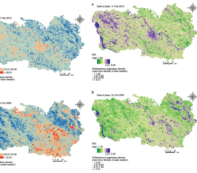
RDVI and its relation to P. argentipes density - The spatial distributions of RDVI for the peak and lean sea-sons derived from the Landsat image were mapped (Fig. 4). The RDVI values were estimated in the range of 1.18 (mean ± SD 0.63 ± 0.32) for the peak season and 0.08-1.85 (mean ± SD 0.96 ± 0.51) for lean season. A lower RDVI value (blue colour) corresponded to a high density of water bodies and built-up areas within the study site. A lower value of RDVI indicated less vegetation associated with a saturation deficit, whereas high RDVI values in-dicated the highly dense and healthy vegetation cover in the study area. Higher RDVI values (green colour) were observed in the central and southern part of the image
due to land covered with mango and lychee plantations. Medium RDVI values (light green areas) were observed over agricultural croplands, in the central, northern and south-eastern parts of the image. This result indicated not only distinct computation procedures for deriving the vegetation density, but also that the area covered by less vegetation has a saturation deficit.
The Pearson’s correlation coefficient between RDVI values and P. argentipes density was calculated. The re-sults of our analysis showed that the minimum and mean RDVI values of both seasons (i.e., lean and peak) tended to be negatively correlated with the sandfly density. The highest negative correlation was found with the mean RDVI (r = -0.66, p < 0.002) and the maximum RDVI (r = -0.55, p < 0.020) during the peak season, followed by the minimum RDVI (r = -0.53, p < 0.045) during the lean season. The smallest correlation was observed with maximum the RDVI (r = 0.13, p < 0.238) during the lean season. RDVI indicators for both the lean and peak seasons showed a strong, negative correlation with the female P. argentipes density; thus a higher sandfly abundance may be associated with a lower RDVI value or less dense vegetation cover.
TABLE I
Season wise collection of sandfly in district of Muzaffarpur, Bihar, India (September 2009-February 2010)
Season
Vector species (n)
Total n (%) Phlebotomus argentipes Sergentomyia Phlebotomus papatasi
Male Female Male Female Male Female
Lean 98 127 90 72 7 2 396 (26.74)
Peak 316 503 139 112 8 7 1,085 (73.26)
Total 414 630 229 184 15 9 1,481 (100)
Relative abundance (%) 70.49 27.89 1.62
As shown in Fig. 4, the spatial distribution of P. ar-gentipes density and RDVI composites during the lean season illustrated that areas with medium RDVI values generally corresponded to areas with the highest P. ar-gentipes MHD. The analysis also demonstrated a similar pattern of P. argentipes abundance during the peak sea-son; e.g., the maximum MHD was recorded in the areas with medium to low RDVI values. This suggests that P. argentipes has a preference for areas that are relatively wet and have lower vegetation density.
A statistical model for delaminating the associa-tion between environmental variables and P. argenti-pes abundance - Multivariate regression analysis was performed to determine the significant environmen-tal variables that affect P. argentipes density. After removing the non-significant variables from the full regression model, the following explanatory variables remained: mean RDVI, mean LST, minimum LST and season (lean and peak). The regression coefficients and significance levels are shown in Table II. The fi-nal model used to assess sandfly density was the fol- lowing equation:
Y = -15.69 + (-2.19 x mean RDVI) + (0.57 x mean LST) + (0.50 x minimum LST) + (-2.88 x season) (5)
where Y (MHD) is the estimated sandfly density.
Fig. 4: distribution of the renormalized differential vegetation indices (RDVI) and vector density in 51 villages during lean season (A) and distribution of the RDVI and vector density in the same villages dur-ing the peak season (B).
Fig. 3: distribution of the land surface temperature (LST) and vector density in 51 villages during lean season (A) and distribution of the LST and vector density in the same villages during the peak season (B).
TABLE II
Significant environmental variables for mapping of sandfly habitat suitability
Environmental variables
Coefficients (βs)
(95% CI) SE
T statistic p
Intercept -15.69 (-22.55, -8.83) 3.46 -4.54 0.000 Mean RDVI -2.19 (-4.76, 0.38) 1.29 -1.09 0.009 Mean LST 0.57 (0.33,0.81) 0.12 4.74 0.000 Minimum LST 0.50 (0.33,0.81) 0.17 2.98 0.004 Season -2.87 (-4.61, -1.15) 0.87 -3.30 0.001
The final model was highly significant (F = 68.66, p < 0.0001), which meant that these four variables, when considered together, were significantly associated with P. argentipes abundance. The adjusted R2 = 0.74 indi-cated that nearly 74% of the variance of P. argentipes density could be explained by these four significant en-vironmental variables. The results indicated that sandfly density increases with (i) decreasing mean RDVI, (ii) in-creasing mean LST, (iii) inin-creasing minimum LST and (iv) peak season or lean season (i.e., lean season consid-ered as a referent category).
DISCUSSION
Like many other diseases, kala-azar is a communica-ble and infectious disease and its distribution, incidence and prevalence are greatly influenced by environmental factors. Our primary aim was to use satellite-derived en-vironmental variables (e.g., LST and RDVI), as proxies for air temperature and vegetation conditions for P. ar-gentipes habitat suitability. In the present study, medium resolution satellite data were used to reflect different as-pects of the natural environment of P. argentipes in the study area during the peak and lean seasons. Previously, researchers have used different approaches to study the risk of leishmaniasis transmission in different parts of the world (Thomson et al. 1999, Gebre-Michael et al. 2004, Valderrama-Ardila et al. 2010, Barón et al. 2011, Ölgen et al. 2012). However, these studies were not based on variables measured using medium or high-resolution spatial data and the studies were conducted in different vector species. Thus, this study is the first attempt to identify the suitable habitat for P. argentipes abundance using these environmental variables in the Indian sub-continent. In previous studies, the density of the vec-tor P. argentipes started increasing in the pre-monsoon and post-monsoon season, when the mean temperature ranged from 27.5-31ºC and the RH ranged from 73-93% (Sharma & Singh 2008, Bhunia et al. 2010b). These stud-ies were based on ground observations and data derived from the Indian Meteorological Department (IMD) sta-tion; satellite data were not used to estimate the surface temperature. During the warmer months, the density is minimal (Napier 1926, Smith 1959, Ranjan et al. 2005) and the temperature in the area ranges between 40-46ºC; the species also disappeared during the winter months, i.e., the lean season (Smith 1959, ICMR 2010). This con-trasts with results obtained from remote sensing data and the percentage surface area occupied by the LST and the RDVI may be used to estimate the abundance of female P. argentipes on the Indian sub-continent. The analysis can identify the probable areas of P. argentipes abundance such that areas mapped as transmission and non-transmission zones appear to accurately fit the real situation. Such a study will help control kala-azar cases vis-à-vis the vector on the Indian sub-continent.
The intricacies of LST determination may be rele-vant to epidemiologists when used as a proxy index in a kala-azar risk model to delineate the favourable areas for vector abundance. Determination of the spatial and temporal variabilities in LST, for example, may be used as correlative index of vector abundance (Malone et al.
1994, Rogers et al. 1996). The LST is computed from a combination of spectral thermal channels of the Landsat TM (channel6). For each single measurement covering an area, LST integrates to the temperature at the surface of that area, e.g., the soil and top of the canopy tempera-tures. A vector abundance vis-à-vis case was lower and negligible when the temperature increased and/or de-creased. However, in our study, we found that the mean and minimum LST values were significantly associated with P. argentipes abundance. However, the maximum MHD during the peak season (i.e., October) was re-corded, with LST values ranging from 29-32ºC. Thus, we suggest that the utility of LST in disease monitoring may be significantly enhanced in epidemiological re-search, especially for kala-azar transmission. For a more accurate result, LST data collected monthly would be required for input into the kala-azar risk model to build a better average representative reading of the studied year’s LST through multi-temporal analysis.
In epidemiology and more generally, vegetation type may be most relevant, in that it reflects and modifies land surface processes such as energy or materials exchange modelling. For example, there are trends towards the de-emphasis of species composition and an increased focus on rate-limiting factors associated with nutrient avail-ability, resource scaling and carbon allocation (Maguire et al. 1996, Goetz & Prince 1999, Carneiro et al. 2004, Bavia et al. 2005). In this circumstance, an indirect link is established between the vegetation index and P. argen-tipes density, such that the vegetation index may be used as a secondary variable for prediction. In our findings, relationships between the RDVI and the saturation defi-cit and vector density, which have been shown to be nega-tively associated, are likely to be non-linear, which are negatively associated with saturation deficit and vector density, when they do occur, are likely to be non-linear. Mean RDVI values are extremely valuable and effective for analysing the conditions of P. argentipes abundance. In this study, we produced a detailed map of RDVI (Fig. 4) that was calculated for a 500 m distance from the cen-tre of the sampling sites and analysed for relationships with the abundance of a sandfly species. In this event, our results prompted the hypothesis that the green bio-mass would have responded to the same environmental triggers as sandflies at that location. Similarly, there are frequently robust associations of disease and vector abundance with the amount and density, rather than the species composition of vegetation cover (Rejmankova et al. 1991, Hay et al. 1998, Thompson et al. 2002).
be-tween the analysed factors and the P. argentipes abun-dance. However, our results are of interest and to add to the obtainable knowledge in the field by elucidating possible relationships between P. argentipes density and environmental variables; our results further provide opportunities for investigation. The information from this study improves our understanding of the effects of on-going ecologic processes that affect P. argentipes abundance and might be useful for developing new input in kala-azar risk models for effective VL control pro-grammes on the Indian sub-continent by providing valu-able information on the preferred periods and sites for applying insecticides.
ACKNOWLEDGEMENTS
We thank the Earth Explorer community of the USGS, for providing free access of satellite data, to Alok Ranjan. All In-All In-dia Institute of Medical Sciences, Patna, for assistance to carry out the statistical calculation, to the co-operation extended by Prasenjit Samanta, senior geographic information system spe-cialist, Descon Ltd, Kolkata, West Bengal, India, for carrying out the model generation, and to NK Sinha, SA Khan, AK Mondal and M Kumar, for their kind co-operation in conduct-ing the successful field work
REFERENCES
Artis DA, Carnahan WH 1982. Survey of emissivity variability in thermography of urban areas. Remote Sens Environ12: 313-329. Barón SD, Morillas-Márqueza F, Morales-Yustea M, Díaz-Sáeza V,
Irigaraya C, Martín-Sánchez J 2011. Risk maps for the presence and absence of Phlebotomus perniciosus in an endemic area of leishmaniasis in southern Spain: implications for the control of the disease. Parasitology138: 1234-1244.
Bavia ME, Carneiro DD, Gurgel H da C, Madureira Filho C, Barbosa MG 2005. Remote sensing and geographic information systems and risk of American visceral leishmaniasis in Bahia, Brazil.
Parassitologia47:165-169.
Beck LR, Lobitz BM, Wood BL 2000. Remote sensing and human health: new sensors and new opportunities. Emerg Infect Dis6: 217-227.
Beck LR, Rodrigues MH, Dister SW, Rodrigues AD, Rejmankova E, Ulloa A, Meza RA, Roberts DR, Paris JF, Spanner MA, Washino RK, Hacker C, Legters LJ 1994. Remote sensing as a landscape epidemiologic tool to identify villages at high risk for malaria transmission. Am J Trop Med Hyg 51: 271-280.
Beck LR, Rodrigues MH, Dister SW, Rodriguez AD, Washino RT, Roberts DR, Spanner MA 1997. Assessment of a remote sensing based model for predicting malaria transmission risk in villages of Chiapas, Mexico. Am J Trop Med Hyg56: 99-106.
Bhunia GS, Chatterjee N, Kumar V, Siddiqui NA, Mandal R, Das P, Kesari S 2012. Delimitation of kala-azar risk areas in the district of Vaishali in Bihar (India) using a geo-environmental approach.
Mem Inst Oswaldo Cruz 107: 609-620.
Bhunia GS, Kesari S, Jeyaram A, Kumar V, Das P 2010a. Influence of topography on the endemicity of kala-azar: a study based on remote sensing and geographical information system. Geospat Health4: 155-165.
Bhunia GS, Kumar V, Kumar AJ, Das P, Kesari S 2010b. The use of remote sensing in the identification of the eco-environmental factors associated with the risk of human visceral leishmania-sis (kala-azar) on the Gangetic plain, in north-eastern India. Ann Trop Med Parasitol 104: 35-53.
Carneiro D, Bavia ME, Rocha W, Lobão J, Madureira Filho C, de Ol-iveira JB, da Silva CE, Barbosa MG, Rios R 2004. Identificação de áreas de risco para a leishmaniose visceral americana através de estudos epidemiológicos e sensoriamento remoto orbital em Feira de Santana, Bahia, Brasil (2000-2002). Rev Baiana Saude Publica28: 19-32.
Combie MK, Gillies RR, Arvidson RE, Brookmeyer P, Weil GJ, Sultan M, Harb M 1999. An application of remotely derived cli-matological fields for risk assessment of vector-borne diseases: a spatial study of filariasis prevalence in the Nile Delta, Egypt.
Photogramm Eng Remote Sensing65: 1401-1409.
Dash P, Gottsche FM, Olesen FS, Fischer H 2002. Land surface tem-perature and emissivity estimation from passive sensor data: theo-ry and practice current trends. Int J Remote Sens 23: 2563-2594. Gebre-Michael T, Malone JB, Balkew M, Ali A, Berhe N, Hailu A,
Herzi AA 2004. Mapping the potential distribution of Phleboto-mus martini and P. orientalis (Diptera: Psychodidae), vectors of kala-azar in East Africa by use of geographic information sys-tems. Acta Trop90: 73-86.
Gillies RR, Carlson TN 1995. Thermal remote sensing of surface soil water content with partial vegetation cover for incorporation into climate models. J Appl Meteorol34: 745-756.
Gillies RR, Cui J, Carlson TN, Kustas WP, Humes KS 1997. A veri-fication of the ‘triangle’ method for obtaining surface soil water content and energy fluxes from remote measurements of the nor-malized difference vegetation index (NDVI) and surface radiant temperature. Int J Remote Sens18: 3145-3166.
Goetz SJ, Prince SD 1999. Modeling terrestrial carbon exchange and storage: evidence and implications of functional coverage in light use efficiency. In AH Fitter, D Raffaelli (eds.), Advance in eco-logical research, Academic Press, San Diego, p. 57-92. Graves PM, Richards FO, Ngondi J, Emerson PM, Shargie EB,
Ende-shaw T, Ceccato P, Ejigsemahu Y, Mosher AW, Hailemariam A, Zerihun M, Teferi T, Ayele B, Mesele A, Yohannes G, Tilahun A, Gebre T 2009. Individual, household and environmental risk fac-tors for malaria infection in Amhara, Oromia and SNNP regions of Ethiopia. Trans R Soc Trop Med Hyg 103: 1211-1220. Hay SI, Snow RW, Rogers DJ 1998. From predicting mosquito habitat
to malaria seasons using remotely sensed data: practice, prob-lems and perspectives. Parasitol Today14: 306-313.
ICMR - Indian Council of Medical Research 2010. Application of GIS and RS technologies in epidemiology and control of vector-borne diseases: a compilation of research contributions of the task force under ICMR, ICRM, New Delhi, p. 55-66.
Jensen JR 2005. Introductory digital image processing, 3rd ed., Pren-tice Hall, New Jersey, p. 113.
Kumar V, Kesari S, Kumar AJ, Dinesh DS, Ranjan A, Prasad M, Sinha NK, Kumar R, Das P 2009. Vector density and the control of kala-azar in Bihar, India. Mem Inst Oswaldo Cruz104: 1019-1022. Kustas WP, Norman JM 1996. Use of remote sensing for
evapotranspi-ration monitoring over land surfaces. Hydrolog SciJl41: 495-516. LPSO - Landsat Project Science Office 2002. Landsat 7 Science Data
User’s Handbook. Available from: landsathandbook.gsfc.nasa. gov/pdfs/Landsat7_Handbook.pdf.
Lewis DJ 1978. The phlebotomine sand flies (Diptera: Psychodidae) of the Oriental Region. Bull Br Mus37: 217-343.
Malone JB, Huh OK, Feller DP, Wilson PA, Wilensky D, Holmes RA Elamadoub AAI, 1994. Temperature data from satellite imagery and the distribution of schistosomiasis in Egypt. Am J Trop Med Hyg 50: 714-722.
Maguire JH, Costa CH, Lamoniere D 1996. Application of remote sensing and geographical information systems (GIS). A new technology to study the transmission of Leishmania chagasi in Teresina, Piauí, Brasil. Proceedings of the Annual VL Symp Rem Sens Pat Infec Dis, USA-NASA, 5 pp.
Markham BL, Barker JL 1985. Spectral characterization of the LAND-SAT Thematic Mapper sensors’. Int J Remote Sens6: 697-716. Mishra R, Kumar P, Nath P 2012. Study of species composition and
diversity of different sandfly species found in Bihar with respect to kala-azar in India. American Journal of Scientific Research 60: 104-111.
Napier LE 1926. An epidemiological consideration of the transmis-sion of kala-azar in India. Indian J Med Res 4: 219-265. Ölgen MK, Özbel Y, Balcioğlu IC, Demir S, Şimşek F, Özensoy Töz
S, Ertabaklar H, Alkan MZ 2012. A new approach for determin-ing the spatial risk levels for visceral and cutaneous leishmaniasis related with the distribution of vector species in western part of Turkey using geographical information systems and remote sens-ing. Kafkas Univ Vet Fak Derg 18 (Suppl. A): A77-A84. Oscar KH, Malone JB 2001. New tools: potential medical application
of data from new and old environmental satellites. Acta Trop79: 35-47.
Picado A, Das ML, Kumar V, Dinesh DS, Rijal S, Singh SP, Das P, Coosemans M, Boelaert M, Davies C 2010. Phlebotomus argen-tipes seasonal patterns in India and Nepal. J Med Entomol47: 283-286.
Ranjan A, Sur D, Singh VP, Siddique NA, Manna B, Lal CS, Sinha PK, Kishore K, Bhattacharya SK 2005. Risk factors for Indian kala-azar. Am J Trop Med Hyg73: 74-78.
Rejmankova E, Saveage HM, Rejmanek M, Roberts DR, Arrendon-dolimenez LL 1991. Multivariate analysis of relationships between habitats, environmental factors and occurrence of anophelene
mosquito larvae (Anopheles albimanus and A. pseudopuntipen-nis) in southern Chiapas, Mexico. J Appl Ecol28: 827-841. Remaudière G 1992. A simplified method for mounting aphids and
oth-er small insects in Canada balsam. Rev Fr Entomol 14: 185-186. Robinson TP, Harris RS, Hopkins JS, Williams BG 2002. An
exam-ple of decision support for trypanosomiasis control using a geo-graphical information system in eastern Zambia. Int J Geogr Inf Sci 16: 345-360.
Rogers DJ, Hay SI, Packer MJ 1996. Predicting the distribution of tsetse flies in West Africa using temporal Fourier processed me-teorological satellite data. Ann Trop Med Parasitol90: 225-241. Roujean JL, Breon EM 1995. Estimating PAR absorbed by
vegeta-tion from bidirecvegeta-tional reflectance measurements. Remote Sens Environ51: 375-384.
Rouse JW, Haas RH, Schell JA, Deering DW 1974. Monitoring veg-etation system in the great plains with ERTS. Proceedings of the 3rd Earth Resources Technology Satellite-1 Symposium, YEAR, DATE, Greenbelt, USA, NASA SP-351, p. 3010-3017.
Sharma U, Singh S 2008. Insect vectors of Leishmania: distribution, physiology and their control. J Vector Borne Dis45: 255-272. Singh B, Suhre DR, Balakrishna V, Marable M, Meyer R, Fernelius
N, Hopkins FK, Zelmon D 1998. Far-infrared conversion materi-als: gallium selenide for far-infrared conversion applications. Prog Cryst Growth 37: 47-102.
Smith ROA 1959. Bionomics of P. argentipes. Bulletine of Calcutta School of Tropical Medicine7: 19-21.
Sobrino JA, Jimenez-Munoza, Paolini 2004. Land surface tempera-ture retrieval from LANDSAT - TM 5. Remote Sens Environ92: 521-534.
Thompson RA, Lima JWO, Maguire JH, Braud DH, School DT 2002. Climatic and demographic determinants of American visceral leishmaniasis in northeastern Brazil using remote sensing technology for environmental characterization of rain and region influences on leishmaniasis. Am J Trop Med Hyg 67: 648-655.
Thomson MC, Elnaiem DA, Ashford RW, Connor SJ 1999. Towards a kala-azar risk map for Sudan: mapping the potential distribution of Phlebotomus orientalis using digital data of environmental variables. Trop Med Int Health 4: 105-113.
Tucker CJ 1979. Red and photographic infrared linear combination for monitoring vegetation. Remote Sens Environ 8: 127-150. Valderrama-Ardila C, Alexander N, Ferro C, Cadena H, Marín D,
Holford TR, Munstermann LE, Ocampo CB 2010. Environmen-tal risk factors for the incidence of American cutaneous leishma-niasis in a sub-Andean zone of Colombia (Chaparral, Tolima). Am J Trop Med Hyg82: 243-250.
Van de Griend AA, Owe M 1993. On the relationship between ther-mal emissivity and the norther-malized difference vegetation index for natural surfaces. Int J Remote Sens14: 1119-1131.
Vincini M, Frazzi E, D’Alessio P 2007. Narrow-band vegetation in-dexes from hyperion and directional chris/proba data for canopy chlorophyll density estimation in maize. Proceedings of the Envi-sat Symposium, 2007 23-27 April, Montreux, Switzerland. Avail-able from: https://earth.esa.int/envisatsymposium/proceedings/ sessions/2D2/507659vi.pdf.
Werneck GL, Costa CH, Walker AM, David JR, Wand M, Maguire JH 2002. The urban spread of visceral leishmaniasis: clues from spatial analysis. Epidemiology13: 364-367.
WHO - World Health Organization 2010a. Control of the leishmania-sis. Report of a meeting of the WHO Expert Committee on the Control of Leishmaniasis. Available from: whqlibdoc.who.int/ trs/WHO_TRS_949_eng.pdf.
WHO - World Health Organization 2010b. Monitoring and evalua-tion tool kit for indoor residual spraying-kala-azar eliminaevalua-tion in Bangladesh, India and Nepal. Available from: who.int/tdr/publi-cations/documents/irs_toolkit.pdf.