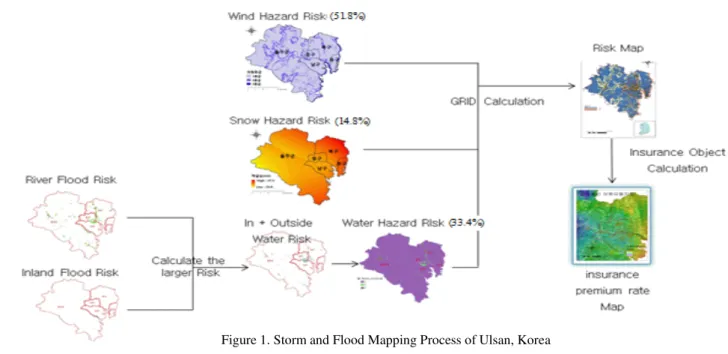
THE STUDY OF INSURANCE PREMIUM RATE GIS MAPPING CONSIDERING THE STORM AND FLOOD HAZARD RISKS
Texto
Imagem

Documentos relacionados
The probability of attending school four our group of interest in this region increased by 6.5 percentage points after the expansion of the Bolsa Família program in 2007 and
Esta temáti- ca tem vindo a ganhar alguma importância, particularmente quando os riscos dão origem a cenários de tensão social (sobretudo quando estamos perante
Mapping the risks of food poisoning in the home is about assessing the food handling practices of consumers considering the occurrence of illness, its severity, associated
72 Sob o marco teórico feminista e dos estudos sobre deficiência, com vistas a contribuir no debate sobre análise de políticas sociais, o presente estudo conclui que apesar do
Recent developments in stream ecology call for a shift in perspective, as local assemblage structure is increasingly thought of as a product of multi-scale factors, and spatial
Considering what was exposed and using data from the National Household Sample Survey, of 2008, this study had the objective of estimating the smoking cessation rate, identifying
Considering as null hypothesis that mapping of the crude rate does not clearly identify the for- mation of agglomerates of deaths, and that the Empirical Bayesian analysis provides
