DETERMINATION OF THRESHOLDS FOR STORM IMPACTS
Ferreira, Ó.1, Almeida, L.P.1, Rodrigues, B.2 and Matias, A.1 ABSTRACT
Storms are responsible for important erosion, coastal retreat and damage when infrastructures are placed within their acting area. The characterisation of storm parameters and associated thresholds for erosion and damage are the-refore of fundamental importance for coastal management purposes. This work presents ways of determining thresholds for important morphological changes (including erosion), overwash occurrence and damage associate to storm oc-currence. These methods were tested and applied to Ancão Peninsula (South Portugal) and the results shown. The use of these approaches will enable coas-tal managers to have a quantitative knowledge of consequences associated to each particular storm and to act accordingly, for instance defining set-back lines, designing nourishments or implementing evacuation plans.
Key words: Storms, Overwash, Erosion, Damage, Management INTRODUCTION
The most rapid and dramatic changes in beach morphology occur during storms. Extreme storms are one of the most important agents causing overwash and beach erosion, and therefore responsible for the destruction of coastal properties on urbanised areas. The main storm variables are wave parameters (namely height), storm duration, sea level and storm surge. When one or more of these variables reach a critical level (threshold) major chan-ges are expected at the studied coastal systems. Therefore, to determine the thresholds responsible for beach erosion and associated damage is of para-mount importance for a responsible coastal planning and management.
1 CIMA, Universidade do Algarve, Faro, Portugal, [email protected], [email protected], [email protected]. 2 School of Geography, University of
This paper shows three methods to determine thresholds for: i) coastal erosion associated to important morphological changes across the beach profile, linking wave height and beach profile vertical variability; ii) overwash occurrence, using the relationship between storm conditions and dune ele-vation; and iii) coastal damage, by historical evaluation. All methods have been applied to Ancão Peninsula, South Portugal (Fig. 1).
Figure 1. Study area location within the Ria Formosa Barrier Island System (adapted from Matias et al., 2009)
THRESHOLDS FOR COASTAL EROSION
Thresholds for coastal erosion are determined by establishing significant wave height (Hs) thresholds responsible for important morphological changes (ver-tical variability) across the beach profile. The methodology comprises a four-step sequence, developed by Almeida et al. (submitted): (1) the definition of the profile active zone; (2) the establishment of cross-shore sectors; (3) the determination of vertical variability; and (4) the definition of thresholds of mor-phological change (relationship between Hs and profile vertical variability). Step (1): The definition of the profile active zone is made by graphically overla-ying all elevation data standard deviations (σ) calculated between surveys. The beach’s upper and lower limits are defined when σ ≤ 20 cm, enclosing the range of errors attributable to instrumentation and human errors. In case of unavai-lable data, the closure depth (lower limit) can alternatively be determined using Hallermeier (1981) or Birkemeier (1985) empirical methods. Step (2): Using the vertical standard deviations the profile is divided into sectors that define the main active zones (Fig. 2). Sectors are separated by areas with lower standard devia-tion, corresponding to minor morphological changes and transitional parts of the profile. High standard deviation corresponds to beach features (e.g., berm or bar
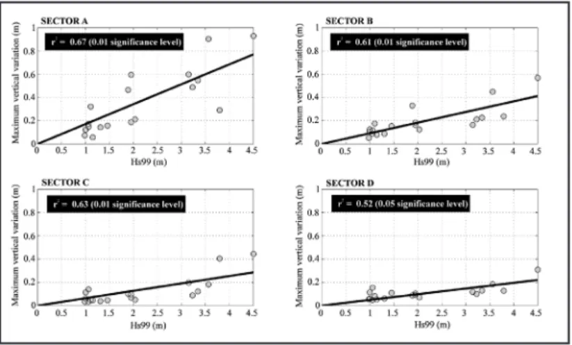
position), with the most important morphological changes. Such beach profile segmentation has been proposed in the past by Winant et al. (1975) and Inman and Dolan (1989). Step (3): The beach profile maximum vertical variation (MVV) is determined for each sector by calculating the modulus of the maximum ver-tical difference between two consecutive surveys. The threshold for important vertical variations is established for each sector, being these variations at least equal to the survey technical error (MVV ≥ 20 cm) or to the average of observed variations for each defined beach sector (e.g. MVV ≥ 40 cm for sector 1). Step (4): The 99th percentile of Hs (Hs99) was used as a proxy to the maximum wave energy conditions between surveys. The best fit equations between Hs99 and MVV (Fig. 3) enables the definition of Hs threshold for important morphological changes (including erosion) for each profile sector.
Figure 2. Definition of 4 cross-shore sectors along the beach profile for Ancão Peninsula based on the standard deviation analysis (adapted from Almeida et al., submitted)
Figure 3. Maximum vertical variation versus Hs99 for sectors A to D with the best fit represented. Statistical significance of correlation showed
Based on the linear regression between Hs99 and MVV three thresholds of morphological change were defined for Ancão Peninsula: Hs99 ≥ 2.3 m dri-ves important morphological changes in Sector A (berm and beach face; Fig. 3); Hs99 ≥ 3.2 m induce important changes in sectors B and C, the sub-tidal terrace and longshore bar, respectively; Hs99 ≥ 4.1 m induce morphological change in Sector D near the depth of closure (Almeida et al., submitted).
THRESHOLDS FOR OVERWASH OCCURRENCE
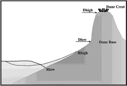
Thresholds for overwash occurrence are based on the storm impact scale proposed by Sallenger (2000). The approach is based on the relation between the elevation of extreme runup level (RHIGH) and the elevation of critical geomorphologic features, the dune base (DLOW) and dune crest (DHIGH). Along beaches with a foredune ridge as RHIGH increases runup will eventu-ally collide with the base of the dune inducing erosion. This collision regime occurs when RHIGH/DHIGH exceeds DLOW/DHIGH. As RHIGH continues to increase, overwash of a dune crest occurs when RHIGH >DHIGH (Fig. 4). In order to predict overwash hazard during storms, scenarios with different return periods are defined (e.g. 5, 10 and 25 years). For each return period, RHIGH is calculated, according to Sallenger (2000):
RHIGH = R2 + ηmean (1)
where R2 is the 2% exceedence level of runup and ηmean is the mean sea level (the sum of the astronomical tide and the storm surge). R2 is obtained through existing empirical parameterisations (e.g. Holman 1986 or Stock-don et al. 2006). Significant wave height and associated storm surge for the defined return period are obtained from data and, when not available, by model predictions.
Figure 4. Description of variables used by Sallenger (2000) for scal-ing the impact of storms on barrier islands
In order to assess the vulnerability to collision and overwash regimes a map is designed setting the topographic layers representing the dune base (DLOW) and crest (DHIGH). The dune features are then compared to the previously calculated RHIGH values. For any given point where the dune base/crest topography is lower than the calculated storm induced runup the area is categorised as vulnerable to collision/overwash. Using GIS the vulnerable areas are represented as buffers in different colours in order to distinguish the vulnerability relative to the storm scenarios.
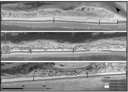
For Ancão Peninsula, collision regime is shown as a constant hazard, whe-reas overwash hazard varies temporally and spatially alongshore (Fig. 5). The shore is largely affected by a storm with 25 year return period, whereas a storm with 5 year return period triggers overwash only at particular sites. The central area is the most vulnerable to overwash not only because of the reflective beach slope but also due to the lowering and destruction of dunes by human intervention. Ancão Peninsula has physiographic characteristics prone to overwash, such as the reflective beach slope and the exposition to the energetic SW events (Rodrigues 2009).
Figure 5. Representation of collision and overwash regimes vulnerabi-lity along Ancão Peninsula for 5, 10 and 25 year return period storms. DH - dune crest position. DL- dune base (downward the georeferenced site for better map representation) (adapted from Rodrigues 2009)
THRESHOLDS FOR COASTAL DAMAGE
The definition of thresholds for coastal damage is made by the analysis of the hydrodynamic conditions associated to historical storm impacts with relevant consequences (i.e. significant damage to infrastructures, such as houses, roads and walls). For this purpose quantitative and qualitative infor-mation is gathered, namely from regional newspapers, unpublished reports, beach surveys and monitoring, and time-series of aerial photographs. This information is used to make a qualitative assessment of storm’s impacts on the coast in the last decades and to identify the associated major storm events (Almeida et al., in preparation). Hydrodynamic conditions for each de-fined extreme event are described using the following parameters: number of storms (from single storm to groups of storms), duration, power, maxi-mum Hs, direction, maximaxi-mum tide and storm surge levels. Storms are ag-gregated into storm groups if the maximum Hs (over the accepted regional storm threshold, e.g. 3 m for Ancão Peninsula) of consecutive storms occu-rred within a short period (30 hours to 10 days for the study area). Offshore wave power (P) is calculated using linear wave theory and integrated along the duration of each event (individual storm or storm group). For each storm or storm group above the damage threshold it is calculated the return period and the annual probability of occurrence through the follow equations:
(2) and
(3)
where Pr is the return period calculated for N, number of years, T is the number of events found in the used years that caused damage and Po is the annual probability of occurrence of the event.
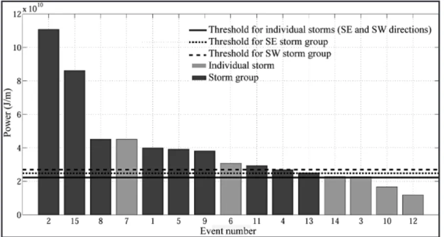
For Ancão Peninsula thresholds for impacts on infrastructures were defined for the two main wave direction (W-SW and E-SE): one for storm groups and other for individual storms, based on the analysis of information for the last 4 decades. The thresholds were firstly based on P (Fig. 6) and afterwards translated to associated Hs and storm duration. Historically documented storms that caused damage to infrastructures, gave a threshold for indivi-dual storms of 4.7 m maximum Hs from a SW direction with duration of 2 days and 6 m lasting 2 days for SE direction. For south-eastern storm groups the threshold was 3 short storms (each storm lasting at least 1 day) with maximum Hs above 3.9 m, while for SW storms the threshold was 2 storms lasting at least 2 days each with maximum Hs of at least 3.5 m (Almeida et al., in preparation). Higher occurrence probability area associated to the SW storms (individual and storm groups) with the damages associated to storm groups showing a lower return period (at each two years in average).
Figure 6. Thresholds defined for storm impacts on infrastructure ba-sed on wave power for Ancão Peninsula (Almeida et al., in preparation)
CONCLUSIONS
This paper presented three methods for determination of thresholds as-sociated to coastal erosion (important morphological changes), overwash occurrence and coastal damage induced by storms. Examples of application were given for the study case of Ancão Peninsula, a coastal area subject to several storms a year that often have direct consequences to human occu-pation. These methods are based on simple approaches and therefore appli-cable to any coastal area where up-to-date coastal morphology (including beach profiling) is available, as well as offshore waves and sea level data for a period encompassing several storms (years to decades). The used techni-ques can easily be adapted to specific beach conditions and therefore useful for a wide range of exposed sandy beaches. Results have direct application on coastal management plans assiting, for instance, on human occupation strategies, dune recovery design and beach renourishment planning.
Acknowledgments: This work was funded from the European Community’s Seventh Framework Programme under grant agreement No. 202798 (MICO-RE Project). Ana Matias was supported by the Fundação para a Ciência e a Tecnologia, grant reference SFRH/BPD/18476/2004.
References
Almeida, L.P., Ferreira, Ó., Pacheco, A. (submitted): Thresholds for morphological changes on an exposed sandy beach as a function of wave height. Earth Surface Processes and Landforms.
Almeida, L.P., Vousdoukas, M.V., Ferreira, Ó., Rodrigues, B., Matias, A. (in preparation): Thresholds for storm impacts on an exposed sandy coastal area.
Birkemeier, W. A. (1985): Field data on seaward limit of profile change. Journal of Waterway, Port, Coastal and Ocean Engineering, 111 (3), 598-602.
Hallermeier, R. (1981): Seaward limit of significant sand transport by waves: an annual zonation for seasonal profiles. Coastal Engineering Techni-cal Aid, 81-2, CERC, 23 p.
Holman, R. A. (1986): Extreme value statistics for wave run-up on a natural beach. Coastal Engineering. 9, 527-544.
Inman, D. L., and Dolan, R. (1989): The Outer Banks of North Carolina: Budget of Sediment and Inlet Dynamics along a Migrating Barrier System. Journal of Coastal Research, 5, 193-237.
Matias, A., Ferreira, Ó., Vila-Concejo, A., Morris, B., Dias, J.A. (2009): Foreshore and hydrodynamic factors governing overwash. Journal of Coastal Research, SI 56: 636-640.
Rodrigues, B.A. (2009): The Ancão Peninsula vulnerability to overwash events. MSc Thesis, University of the Algarve, 53 p. Sallenger, A.H. (2000): Storm impact scale for barrier islands. Journal of Coastal Research. 16, 890-895.
Stockdon, H. F., Holman, R. A., Howd, P. A., Sallenger, A. H. (2006): Empirical parameterization of setup, swash, and runup. Coastal Engineering, 53, 573-588.
Winant, C.D., Inman, D.L., Nordstorm, C.E. (1975): Description of seasonal beach changes using empirical eigenfunctions. Journal of Geophysical Research, 80(15), 1979-1986.