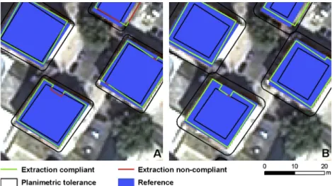
Introducing mapping standards in the quality assessment of buildings extracted from very high resolution satellite imagery
Texto
Imagem


Documentos relacionados
Automatic detection and classification of damaged buildings, using high resolution satellite imagery and vector data. In: The International Archives of the Photogrammetry,
Multispectral sensors on-board satellite, aerial and UAV platforms are nowadays the main source of information for precision agriculture and environmental
To produce an accurate map for individual tree species and tree canopy, however, high spatial and spectral resolution satellite imagery is required especially in highly
Several authors have already focused on the problem of automatic land cover mapping from multitemporal and multispectral satellite images of medium spatial resolution
Já as variáveis relativas à utilização das academias ao ar livre (frequência de utilização, tempo de permanência, dias e turno que frequenta, nível de esforça que
L’idée de consacrer une séance à la mise en scène et à la mise en exposition de la chasse dans les cultures extra-européennes est née d’un double constat : d’une part, les
The significant differences in the female digested urine nitrogen from that of the male and the composite from the 2nd to 5th months of storage can be ascribed to the
concordaram, nem discordaram. Ora, mais de 18% destes jovens acredita numa mudança nas sociedades atuais, através da eliminação da fome e da pobreza. Na segunda afirmação, 50%
