1Department of Geology and Natural Resources, Institute of Geocience, Universidade Estadual de Campinas - UNICAMP, Campinas (SP), Brazil.
E-mail: [email protected]; [email protected]; [email protected]
2Institute of Geoscience, Universidade de Brasilia - UnB, Brasília (DF), Brazil. E-mail: [email protected]
3Institute of Language Studies, Universidade Estadual de Campinas - UNICAMP, Campinas (SP), Brazil. E-mail: [email protected]
*Corresponding author
Manuscrito ID: 30113. Recebido em: 05/05/2014. Aprovado em: 21/10/2014. ABSTRACT: his paper introduces a methodology which makes possible the visualization of the spatial distribution of plant fossils and applies it to the occurrences of the Gondwana Floristic Province present on the eastern border of the Brazilian portion of the Paraná Basin during the Neopaleozoic. his province was chosen due to the existence of a large number of publications referring to their occur-rence, so that a meta-analysis of their distribution could be based on ample information. he irst step was the construction of a composite database including geographical location, geology, and the botanical systematics of each relevant fossil. he geographical locations were then georeferenced for translation into various maps showing various aspects of the distribution of the fossils. he spatial distribution of the fossil-housing outcrops shows that these are distributed along the area of deposition studied. Although some genera persisted for long periods of time, others lasted for only short intervals. As time passed, the fossil composition underwent a gradual change from the Late Carboniferous (Itararé Group) to the Late Permian (Rio do Rasto Formation), with the number of genera represented decreasing from 45 in the Itararé Group to 11 in the Rio do Rasto Formation.
KEYWORDS: Geographic Information Systems; Gondwana Floristic Province; Paraná Basin; Floristic Maps.
RESUMO: O presente artigo introduz a uma metodologia na qual será possível a visualização da distribuição espacial de itofósseis. Tal metod-ologia será aplicada a ocorrências da Província Florística do Gondwana presente na borda leste da porção brasileira da Bacia do Paraná durante o Neopaleozóico. Essa província foi escolhida tendo em vista que nela há grande número de publicações referentes às suas ocorrências. Isso tor-na possível a meta-análise de sua distribuição, uma vez que há ampla gama de informações. O primeiro passo foi a construção de uma base de dados composta, incluindo localização geográica, geologia e sistemática botânica de cada fóssil de interesse. As informações foram então georrefer-enciadas para posterior transferência em diversos mapas mostrando vários aspectos da distribuição fossilífera. Através de sua distribuição espacial, se pode contatar que os itofósseis se encontram amplamente distribuídos em toda a área de estudo. No entanto, alguns gêneros persistem por longos períodos de tempo, já outros somente por curtos intervalos. Ao longo do tempo, a composição fossilífera se transformou gradualmente, desde suas primeiras ocorrências no Grupo Itararé (Neocarbonífero), até a Formação Rio do Rastro (Neopermiano), com o número de gêneros decrescendo de 45 no Grupo Itararé para 11 na Formação Rio do Rasto.
PALAVRAS-CHAVE:Sistemas de Informação Geográica; Província Florística do Gondwana; Bacia do Paraná; Mapas Florísticos.
New approach for the study of paleoloras
using geographical information systems
applied to
Glossopteris
Flora
Nova abordagem para o estudo das paleoloras utilizando sistemas
de informação geográica aplicada a Flora Glossopteris
Isabel Cortez Christiano-de-Souza1*, Fresia Ricardi-Branco1,
Adalene Moreira Silva2, Linda Gentry El Dash3, Rafael Souza Faria1
INTRODUCTION
his paper was designed to provide a meta-analysis of the spatial and temporal distribution of late Paleozoic plant fossils in the Brazilian part of the Paraná Basin. It was based on the composite data reported in the specialized literature and the use of the tools of Geographic Information Systems (GIS, especially the software ArcGIS®), as this made it possi-ble to determine some of the characteristic elements of this Gondwana loristic province.
Although individual fossils are usually treated as inde-pendent elements, to be described and listed in an attempt to deine biostrategraphic zones, the procedure used here made it possible to generate maps deining overall distribu-tion. What was proposed here was thus the creation of maps showing the location of the Gondwana Floristic Province in the Paraná Basin using the tools of GIS and a survey of the bibliographic publications available. he inal results included 1,208 lines of data (each one about a single species in a speciic location, found in a total of 281 outcrops), based on the information contained in the references consulted.
hese data made it possible to obtain information about the spatial and temporal distribution of these fossil species, as well as identifying interrelationships between the genera and the location where they were found, thus providing a single valid interpretation for the large volume of informa-tion available. It is hoped that this will provide a more real-istic idea of the evolution of Gondwana Florreal-istic Province at the Paraná Basin, as well as identifying the more preva-lent genera of the various time periods, spatial distribution and generating new information about their provenance.
METHODOLOGY
Theoretical Revision: The Paraná Basin
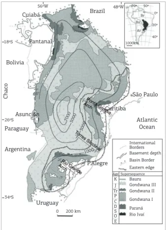
he Paraná Basin is an intracratonic basin located on the South American continent; it includes parts of the territory of four countries (Brazil, Paraguay, Argentina, and Uruguay), with a total of 1.5 million square kilometers (Milani et al. 2007). he basin is an ellipse running from NNE-SSW, with its borders at present deined by erosion related to the tec-tonics of the Meso-Cenozoic ages. he deposition occurred in the interval which stretches from the Late Ordovician (450 Ma) until the end of the Cretaceous (66 Ma).
he sedimentary/magmatic package of the Paraná Basin reaches a maximum depth of 7 thousand meters, where it coincides geographically with the valley of the Paraná River. Figure 1 shows the Brazilian portion of the basin. he location coincides with a series of sedimentary packages indicating
a series of marine oscillations, as well as events of subsid-ence and rising, characteristic of the polycyclic regime of the basin. Milani (1997) has divided the Paraná Basin into six large-scale units or supersequences, deined by layers of rocks encompassing deposition intervals of tens of millions of years, layered between inter-regional discordances hese supersequences include the Rio Ivaí (Ordovician – Silurian); Paraná (Devonian); Gondwana I (Carboniferous – Early Triassic); Gondwana II (Middle Triassic – Late Triassic); Gondwana III (Late Jurássic – Early Cretáceous) and Bauru (Late Cretaceous).
he Gondwana I Supersequence contains fossils of the Gondwana Floristic Province (traditionally treated as Pre-Glossopteris and Glossopteris paleoloras); it is composed of the Itararé, Guatá, and Passa Dois groups, as well as the Pirambóia and Sanga do Cabral Formations. his Supersequence rep-resents the greatest volume of sediments in the Paraná Basin, some 2,500 m in depth (Milani et al. 2007), and traces a history of marine transgressions and regressions of the gla-cial period of the Pennsylvanian to the continental environ-ment of the Lopingian.
Bolivia
Pantanal Cuiabá
Uruguay
International Borders Basement depth Basin Border Eastern edge Supersequence Age
K J Tr P C D S O E
Rio Ivaí Paraná Gondwana I Gondwana II Gondwana III Bauru Paraguay
Atlantic Ocean São Paulo Brazil
Curitiba Asunción
Chaco
P.Alegre
1000
5000
5000
3000 7000
Argentina 18ºS
56ºW 48ºW 70º 50º
0º
20º
40º 1000km
Ar Bo
Br
26ºS
34ºS
0 200 km
During the Late Carboniferous, the southern part of the paleocontinent of Gondwana was located at a higher latitude (greater than 60° South), a context of extensive continental glaciations which is relected in the deposition of the Itararé Group in the Paraná Basin. he progressive migration of the paleocontinent to lower northern latitudes during the Permian led to a series of climatic changes, with the melting of the ice accompanied by the consequent rise in relative sea level (Permian transgression) (Rees 2002; Milani et al. 2007).
Later in the Permian, a decrease in the relative sea level led to the formation of an inland sea, with a lim-ited circulation of water and a gradual hypersalination of the environment associated with isolated shallow bays, which is relected in the deposits of organic material in an anaerobic environment in the Passa Dois Group. Still later, during a large-scale regression, a continental system developed, with sedimentation eventually leading to the complete illing of the basin during the Guadalupian and the installation of semi-arid or desertic sedimentary envi-ronments at the end of the Permian and beginning of the Triassic (Milani et al. 2007).
he macrophyte fossils found in this supersequence have been studied by the scientiic community since the eighteenth century. Collected, described and included in the collections of the larger museums, they have contrib-uted much to our knowledge of the evolution of plant com-munities. hey furnish a clear picture of the plant life on southwestern portion of the supercontinent of Gondwana during the end of Paleozoic Era.
The Map Construction
his paper provides a composite database about plant fossil occurrences reflecting a compilation of informa-tion furnished by three types of sources: (a) reports about Carboniferous and Permian macrophyte fossils found in a review of 100 years of bibliographic references; (b) informa-tion about geology supplied by the geologic map of Brazil (scale of 1:100000), furnished by the Geological Service of Brazil (CPRM); and (c) information about altitude furnished by the Shuttle Radar Topography Mission (SRTM) of the American National Aeronautics and Space Administration (NASA). his compilation has made it possible to construct maps showing the distribution of plant fossils in the Paraná Basin using ArcGIS® software. Details of the three elements are discussed below.
Bibliographic references
Initially, an attempt was made to recuperate as much data as possible about plant fossils in the Late Carboniferous and Permian in the Paraná Basin. In addition to the traditional
foreign sources (Derby 1915, Lundqvist 1919, Florin 1940, Rao 1940), an extensive survey was made of articles, books, and theses available in Brazil. A total of 158 references pub-lished in a period of more than a hundred years were located, reviewed and analyzed.
Geologic map of the Geological Service
of Brazil (CPRM)
he Geological Map of Brazil (scale of 1:1000000), with pages in the form of vectorial archives (shapeiles), is available for download from the Geobank database of the CPRM (http://geobank.sa.cprm.gov.br/) (CPRM 2004).
The outcrops of Gondwana I on these pages of the Geological Map of Brazil are generally those found in the southern and southeastern part of Brazil (below the latitude of 20° South), i.e., pages SF21–SF24, SG21–SG23, SH21– SH22, and S122. hese pages were united in a single vec-torial archive using ArcGIS® software.
SRTM Mosaic
he SRTM altimetric data utilized here were generated using Interferometry Synthetic Aperture Radar (InSAR) technology, operating with antennas for the C and X bands (Carneiro 2005, Rabus et al. 2003). hese data, presented as a Digital Model of Elevation with a spatial resolution of 3 arc sec (~ 90 m) and a radiometric resolution of 16 bits for South America, were collected between the days of February 11-22, 2000. his information was made available by NASA on the electronic address ftp://edcsgs9.cr.usgs.gov/pub/data/ srtm/South_America.
The Composite database
he composite database developed here is presented in a simple model, known as a hierarchic model, which has often proved useful in the natural sciences (Burrough 1986). his database was developed on the basis of four key attributes: (a) geographical outcrop; (b) geological information based on lithostratigraphy, geochronology, lora, environment of deposition, (c) paleobotany (systematics and data about the fossils); (d) and bibliographic references.
Outcrop
he irst group of attributes is related to the general data about the spatial location of the outcrop, including:
■ Name: Outcrop names generally make reference to the geographical location, or they are identiied by num-bers, as deined by the author of a study or collection.
outcrops from the Late Carboniferous – Permian interval on the eastern edge of the Brazilian portion of the Paraná basin were considered (Rio Grande do Sul, Santa Catarina, Paraná, and São Paulo) and the municipalities are those in these states where fos-sil-bearing outcrops have been identiied.
■ Coordinates: he coordinates utilized are those presented in the articles, theses, congress abstracts, etc. consulted. When exact coordinates of locations were not mentioned in the original reference, these were inferred by the use of a map portraying georeferenced highways or hybrid georeferenced satellite photographs showing georeferenced roads and geo-graphical coordinates. All coordinates are reported to the speciication of a single decimal place (various possible maps are available, such as WikiMapia – (http://wikimapia.org) and ACME Mapper – (http://mapper.acme.com). When the authors did not report exact locations, the central point of the municipality was used, with the lithology being con-sidered as carefully as possible. he datum for the maps of Geomapas, as well as for most of the coordinates cited, was reported for the “Córrego Alegre” datum. For those in the CPRM, the datum was SAD69.
Geological information
he geology of the composite database considered the geological attributes of the outcrops of the Gondwana I Supersequence along the eastern edge of the Paraná Basin,
in which the paleoloras of the Late Carboniferous-Permian interval are recorded. he information in the key was limited to location in the Itararé, Guatá, and Passa Dois groups, with their composite formations, without men-tion of speciic lithology and lithofacies present in each outcrop, since multiple lithologies can be found in a single outcrop.
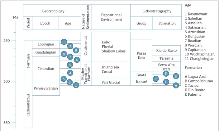
■ Lithostratigraphy: he Gondwana I Supersequence is com-posed of what is today known as the Itararé, Guatá, and Passa Dois groups, as well as the Pirambóia and Sanga do Cabral formations (Milani et al. 2007) (Fig. 2). he names of groups, formations, and members reported in the original articles, however, did not always correspond to this usage, and certain adaptations were necessary to accommodate changes in terminology of the lithostra-tigraphy of the basin throughout the years.
■ Geochronology (Períod, Epoch and Age): he informa-tion about geological age relects the work of Milani et al. (2007) for the stratigraphy of the Paraná Basin, with the geologic age of each formation used as a point of reference.
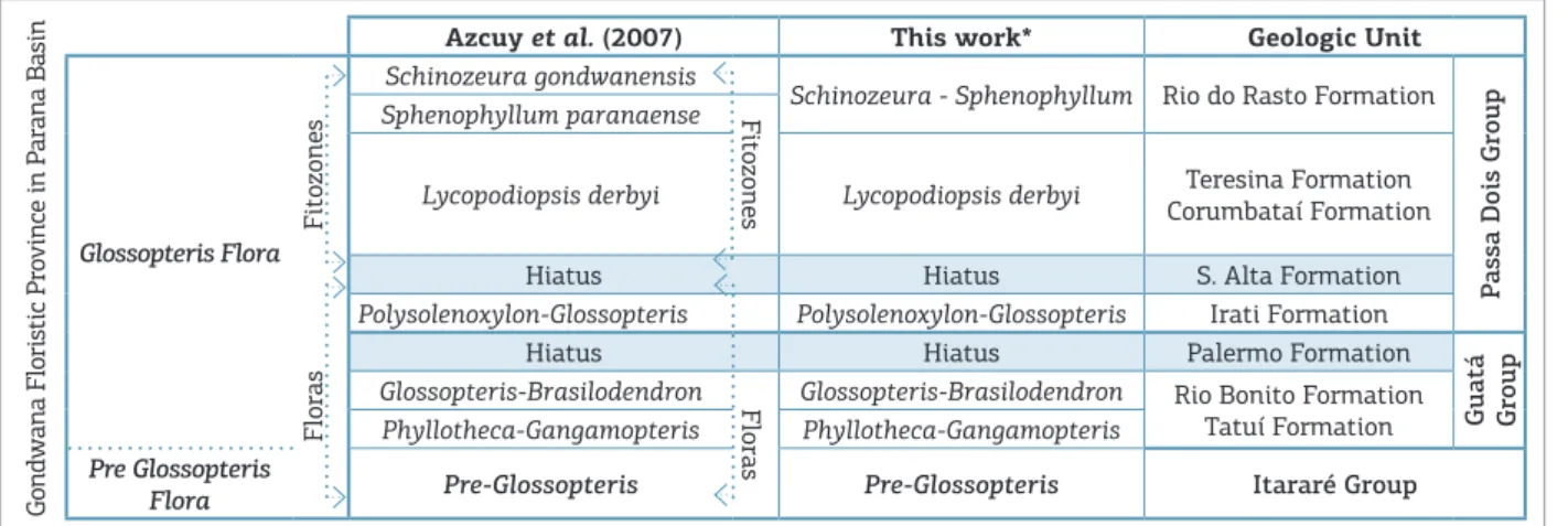
■ Flora: Usually the Gondwana Floristic Province for the Paraná basin is divided into the Pre-Glossopteris and Glossopteris paleoloras, with the latter divided into 5 subdivisions (Fig. 3) (Rösler 1978, Rohn & Rösler 2000, Rees 2002, Iannuzzi & Souza 2005, Azcuy et al. 2007). he Pre-Glossopteris Paleolora
Figure 2. Stratigraphic column of the Late Paleozoic in the Paraná Basin (Modiied from Milani et al. 2007).
Age
1 Kasimovian 2 Gzhelian 3 Asselian 4 Sakmarian 5 Artinskian 6 Kungurian 7 Roadian 8 Wordian 9 Capitanian 10 Wuchiapingian 11 Changhsingian
Formation
A Lagoa Azul B Campo Mourão C Taciba D Rio Bonito E Palermo
Geocronology Lithostratigraphy
Depositional Environment Epoch
Lopingian Eolic
Fluvial Shallow Lakes Guadalupian
Inland sea Costal
P
ermian
Carbonif
erous
Cisuralian
Guatá
Itararé
Teresina Rio do Rasto
Peri Glacial
Passa Dois
Pennsylvanian
Group
Age Formation
P
eriod
Nature of Sedimentation
Continental
Marine
T
ransitional, Platf
orm
Ma
250
300
350
Serra Alta Irati 11
10
8 7
6 5
4
3 2
1 B
D
A C
9
(Azcuy et al. 2007) is what is found in outcrops of the basal portions of the Itararé Group and is character-ized by species of the following genera: Gangamopteris, Rubidgea, Samaropsis, Botrychiopsis, Cordaicarpus, and Paracalamites. hese fossils are overlain by those of the irst subdivision of the Glossopteris Paleolora, the Phyllotheca-Gangamopteris lora (found at the top of the Itararé Group and in the lower layers of the Rio Bonito Formation), which includes the irst register of the genus Glossopteris, while Gangamopteris pre-dominates. he second subdivision consists of the Glossopteris-Brasilodendron lora of the central and upper layers of the Rio Bonito Formation, the lora with the greatest diversiication of genera in the basin, in which Gangamopteris decreases, while Glossopteris increases in abundance. he third subdivision, the Polysolenoxylon-Glossopteris lora, is found in the over-lying Irati Formation; which includes various registers of fossilized wood in addition to plants of the genera of Glossopteris. he more recent lora is traditionally divided into various plant zones, each housing a pre-dominance of speciic species/genera (Rohn & Rösler 2000), but here these are designated as lora. he irst, the Lycodiopsis derbyi lora, registered in the Teresina/ Corumbataí formations, reveals principally lycopsids, but also some equisetopsids, “pteridosperms”, and the predominant Glossopteris, althoughthe Gangamopteris have disappeared from the fossil record. he second of these is denominated the Sphenophyllum/Schiunozeura lora and includes the Sphenophyllum paranaense and Schinozeura gondwanensis plant zones, found only in the Serrinha Member of the Rio do Rasto Formation and in the Morro Pelado Member, respectively, and the number of species of Glossopteris has been sur-passed by that of Paracalamites.
■ Paleoenvironment: he depositional environment suggested by the geological formation is included in the data base, following the proposal of Milani et al. (2007) (Fig. 2). his attribute can then be compared with the environ-ment characteristic of each plant species.
Paleobotany
he third group of attributes included in the key involves botanical information about the fossils included in the data-base, as well as data about their systematics, structures, pro-cess of fossilization involved, and possible transport.
■ Paleontological systematics: he systematics deined by the author are included, as well as the tendencies sug-gested by the present-day division of the plant kingdom and the most recent modiications in the classiication and identiication of plant fossils. he system of classi-ication used in the composite database was based on Frey (2009) and Taylor et al. (2008).
■ Structures preserved: Various kinds of plant vestiges were reported, including vegetative organs, such as leaves, stems, branches, trunks, and roots, as well as reproduc-tive organs (including seeds and sporangia). his infor-mation can be useful because it can provide an indica-tion of whether or not a speciic structure could have been transported for a long distance.
■ Type of preservation: he type of preservation refers to the process of fossilization and to the material of which the fossil is composed. he plant fossils present in the Paraná Basin consist of compressions, impressions, and permineralizations.
■ Environment suggested by the botany of taxa: he infor-mation about environment suggested by the character-istics of a taxon may be diferent from that suggested by geology. Geology interprets the environment as a whole, generally by consideration of sedimentary
Figure 3. Division of plant succession found in the Paraná Basin during the Late Paleozoic, and the respective geological units where they were found.
Azcuy et al. (2007) This work* Geologic Unit
Glossopteris Flora
F
itozones
Schinozeura gondwanensis
Schinozeura - Sphenophyllum Rio do Rasto Formation
P
assa Dois Group
Sphenophyllum paranaense Fitozones
Lycopodiopsis derbyi Lycopodiopsis derbyi Teresina Formation Corumbataí Formation
Hiatus Hiatus S. Alta Formation
Floras
Polysolenoxylon-Glossopteris Polysolenoxylon-Glossopteris Irati Formation
Hiatus Hiatus Palermo Formation
Guatá Group Glossopteris-Brasilodendron Floras Glossopteris-Brasilodendron Rio Bonito Formation
Tatuí Formation Phyllotheca-Gangamopteris Phyllotheca-Gangamopteris
Pre Glossopteris
Flora Pre-Glossopteris Pre-Glossopteris Itararé Group
Gondwana Floristic Pro
vince in P
Types of plants Environment
Coniferous, Cordaitales
and others gymnosperms Outside the Basin (allochthonous)
Seed Ferns Floodplain - outside the depositional area (probably allochthonous)
Ferns margins of water bodies - loodplain
Sphenophytes Floodplain
Lycophytes Margin of water bodies - Marshes
Bryophytes and
marchantiophytes Margin of water bodies - Swamps
Algae Inside the water bodies
Incertae sedis ?
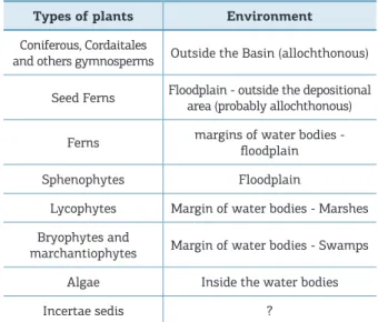
Table 1. Ratio of plant species x environment with the greatest probability of development.
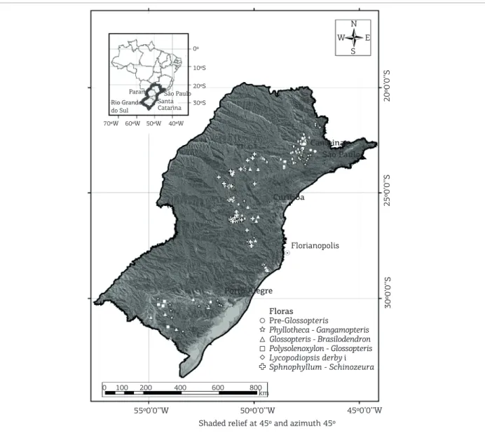
Mapping the distribution of the fossils of different floras (Fig. 4) makes it possible to trace the changes in flora with changes in climate, as revealed by the geol-ogy of the region. The lack of Pre-Glossopteris fossils in the central and southern portions of the Paraná Basin was to be expected, since during the Carboniferous this part of Gondwana was located close the South Pole and is assumed to have been covered by ice, precluding the development of plant communities (Veevers 2004). However, the most common map (Scotese 2001) of Carboniferous Gondwana also shows the northern por-tion covered by ice, yet the presence of Pre-Glossopteris fossils proves that at least part of the time, this region was uncovered and had conditions for the development and flourishing of plants.
he map also shows that at the end of the Permian, which has been interpreted as having a dry, desertic climate, plants still lourished, at least in certain regions, probably the deeper parts of the basin.
he second map (Fig. 5a) emphasizes this conclusion. It maps the occurrences of the fossils of the genera Paracalamites, Sphenophyllum, and Schizoneura, which lourish in humid environments. his mapping reveals regions which were probably swampy during the Late Carboniferous-Permian interval, despite the overall aridization of the region, the central portion of the basin reveals a large concentration of plant fossils. hese wet spots may have represented the deepest portions of the basin, with the relatively calm and shallow waters still remaining, thus permitting the deposi-tion and burial of fragile leaves and stems without destruc-tion during transportadestruc-tion.
The third map (Fig. 5b) identifies geographical fea-tures such as paleodrainage patterns, which are indi-cated by the concentration of possibly allochthonous plant debris. The fossils of possibly the genera of alloch-tonous plants were plotted in circles with a radius of about 10 km, which was considered to correspond to a distance which resistant plants and fragments, such as trunks and seeds, could have been transported (Spicer 1980, Ricardi-Branco et al. 2009). Many of these areas overlie each other for the different floras in different time periods, i.e., the locations of deposition during dif-ferent periods are the same, which suggests that, despite the decrease in water level in the basin throughout the Permian, the zones most propitious for the deposition of plants did not change much.
In the northern part of the basin, a certain N-S ver-tical tendency in areas where different floras were depos-ited can be seen. This line suggests the location of an ancient river mouth during a period of regression. Plant fragments needing greater energy for transport tend to features (lithology, granulometry, geologic structures,
etc.) and ofers a general panorama, rather than exact information about a speciic location. Fossils, how-ever, especially autochthonous and parautochthonous, furnish information about a more speciic location, since plants are stationary and intimately linked to the interaction of conditions such as climate, humid-ity, and illumination (Tab. 1).
■ Possible distance transport: his category indicates the possible spatial displacement of a specimen from its original habitat to the location of deposition. his was classiied by the separation of the original plants into (a) fragile plants or structures which could not have withstood transport for long distance; (b) those which could have withstood limited transport; and (c) more resistant plants or structures, which are fre-quently transported for long distances and deposited outside their normal habitat. he latter, such as seeds and trunks, are very resistant plant structures that could have been transported throughout the basin, and their presence would not be a good paleoenvi-ronmental indicator, although the presence of frag-ile structures such as leaves, which would at least be broken down if subject to transport, suggests depo-sition at or close to the point of origin.
RESULTS
20º0’0’’S 0º
N
S E W
São Paulo Paraná
Santa Catarina Rio Grande
do Sul
10ºS
20ºS
30ºS
70ºW 60ºW 50ºW 40ºW
25º0’0’’S
30º0’0’’S
45º0’0’’W 50º0’0’’W
55º0’0’’W
Shaded relief at 45º and azimuth 45º Porto Alegre
Florianopolis Curitiba
Sao Paulo Campinas
0 100 200 400 600 800 km
Floras Pre-Glossopteris
Phyllotheca - Gangamopteris Glossopteris - Brasilodendron Polysolenoxylon - Glossopteris Lycopodiopsis derby i Sphnophyllum - Schinozeura
Figure 4. Map of the distribution of outcrops by loras in the Paraná Basin. (CPRM 2004 – Shaded relief at 45° and azimuth 45°).
be deposited in such locations. Since the older plant fos-sils are found further to the south and the newer ones to the north, it seems that as regression progressed, the mouth of a river and its associated deposits retreated northward, for a distance of more than 150 km during the Late Carboniferous – Late Permian interval.
CONCLUSIONS
The methodology proposed here which uses geo-referenced paleontological data for the development of thematic maps of the succession of some five floras over an extended time period of 60 million years has proved to be efficient for the interpretation of the distribution
Figure 5. (A) Distribution in the Paraná Basin of Paracalamites, Sphenophyllum, and Schizoneura, genera characteristic of swampy regions. (CPRM 2004 – Shaded relief at 45° and azimuth 45°). (B) Potential allocthones taxa of the loras of the Paraná Basin (including a bufer of 10 km around each occurrence) (CPRM 2004 –Shaded relief at 45° and azimuth 45°).
S E W
S E W
25º0’0’’S
30º0’0’’S
Genus
Floras
Paracalamites sp.
Schizoneura sp.
Sphenophyllum sp.
Sphenophyllum - Schizoneura Lycopodiopsis derbyi Polysolenoxylon - Glossopteris Glossopteris - Brasilodendron Phyllotheca - Gangamopteris
Pre - Glossopteris
Geochronology Era Period
Triassic
Permian
Carboni- ferous Paleozoic Guatá
Itararé
Pirambóia
Rio do Rasto Teresina Serra Alta Irati
Palermo Rio Bonito Taciba Itu Aquidauana
Tatuí Corumbataí
(SP)
Estrada Nova
(RS)
Passa Dois
Group Formation Gondwana I Lithostratigraphy
25º0’0’’S
30º0’0’’S
50º0’0’’W
55º0’0’’W
45º0’0’’W 50º0’0’’W
55º0’0’’W 55º0’0’’W 50º0’0’’W 45º0’0’’W
Geological Map of Brazil, 1:1.000.000 scale - CPRM. Shaded relief at 45º and azimuth 45º Shaded relief at 45º and azimuth 45º
0 100 200 400 600 800
km
0 100 200 400 600 800
km
Brazilian Journal of Geology
, 44(4): 681-689, December 2014
688
New approach f
or studies of
Glossopteris
Azcuy C.B.A., Beri A., Bernardes de Oliveira M.E.C., Carrizo H.A., Di Pasquo M, Saraiva P.D., Gonzales C., Iannuzzi R., Lemos V.B., Melo J.H.G., Pagani A., Rohn R., Amenabar C.R., Sabbatini N., Souza
P.A., Taboada A., Vergel M.M. 2007. Bioestratigraia del Paleozoico
Superior de América del Sur: Primera etapa de trabajo hacia una
nueva propuesta cronoestratigráica. Publicaciónes Especiales de la Asociación Paleontológica Argentina, 11:9-65.
Burrough P.A. 1986. Principles of Geographical Information
Systems for Land Resources Assessment. Oxford, Oxford University Press, 54 p.
Carneiro C.C. 2005. Interpretação de dados de sensores remotos
e aerogeofísicos como ferramenta na análise estrutural da área centro-oeste do Sistema Transcorrente Carajás (PA). MS Dissertation, Instituto de Geociências, Universidade Estadual de Campinas, Campinas, 100 p.
Compania de Pesquisas de Recursos Minerais (CPRM). 2004.
Carta Geológica do Brasil ao Milionésimo: sistema de informações
geográicas-SIG, escala 1:1.000.000. Brasília, Ministério de Minas e
Energia.
Derby O.A. 1915. Illustrations of the Stem structure of Tietea
singularis. American Journal of Science,39:251-260.
Florin R. 1940. Die Koniferen des Oberkarbons und des unteren
Perms. Palaeontographica Abteilung B, 85:243-363.
Frey A. 2009. Syllabus of Plants Families. Bryophytes and Seedless
Vascular Plants. 13 ed., Berlin, Gebrüder Berntraegen, 419 p. Iannuzzi R. & Souza P.A. 2005. Floral succession in the Lower Permian deposits of the Brazilian Paraná Basin: an up-to-date
overview. New Mexico Museum of Natural History and Science
Bulletin,30:144-149.
Lundqvist, G. 1919. Fossile Planzen der Glossopteris Flora aus Brasilien.
KunglSvenska Vetenskaps-Akademiens Handlingar,60:1-36. Milani E.J., Melo J.H.G., Souza P.A., Fernandes L.A., França A.B. 2007. Bacia do Paraná. Boletim de Geociências da Petrobras, 15(2):265-287.
Milani E.J. 1997. Evolução Tectono-Estratigráica da Bacia do
Paraná e de seu Relacionamento com a Geodinâmica Fanerozóica do Gondwana Sul-Ocidental, PhD Thesis, Universidade Federal do Rio Grande do Sul, Porto Alegre. 255 p.
Milani E. (2004). Comentários sobre a origem e a evolução tectônica
da Bacia do Paraná. In: Mantesso-Neto V., Bartorelli, A., Carneiro
C.D.R., Brito-Neves B.B. (org). Geologia do Continente Sul-Americano:
Evolução da Obra de Fernando Flavio Marques de Almeida. São Paulo: Ed. Beca, p. 265-279.
Rabus B., Eineder M., Roth A., Bamler R. 2003. The Shuttle Radar Topography Mission – a New Class of Elevation Models Acquired
by Spaceborne Radar, Journal of Photogrammetry & Remote
Sensing, 57:241-262.
Rao H.S. 1940. On the anatomy of Lycopodiopsis derbyi renault with
remarks on the Southern Palæozoic Lycopods. Proceedings of the
Indian Academy of Sciences - Section B, 11(5):197-217.
Rees P.M., Ziegler A.M., Gibbs M.T., Kutzbach J.E., Behling P., Rowley D.B. 2002. Permian phytogeographic patterns and climate data/
model comparisons. Journal of Geology, 110:1-31.
Ricardi-Branco F., Branco F.C., Garcia R.F., Faria R.S., Pereira S.Y., Portugal R., Pessenda L.C., Pereira P.R.B. 2009. Features of plant accumulations along the Itanhaém River, on the southern coast of
the Brazilian state of São Paulo. PALAIOS,24(7):416–424.
Rohn, R. & Rösler O. 2000. Middle to Upper Permian
phytostratigraphy of the Eastern Paraná Basin. Revista da
Universidade de Guarulhos,5:69-73.
Rösler O. 1978. The Brazilian eogondwanic loral succession. Boletim IG – USP, 9:85–90.
Scotese C.R. 2001. Atlas of Earth History. Texas, Arlington,
vol. 1, 52 p.
Spicer R.A. 1980. The importance of depositional sorting to the
biostratigraphy of plant megafossils. In: Dilcher, D.L., Taylor,
T.N. (eds.) Biostratigraphy of Fossil Plants: Successional and
Paleoecological Analyses. Pennsylvania, Hutchinson & Ross, p. 171-183
Taylor T.N., Taylor E.L., Krigs M. 2008. Paleobotany: The biology and
Evolution of Fossil Plants. Amsterdam, Elsevier Inc, 1252 p.
Veevers J.J. 2004. Gondwanaland from 600-570 Ma assembly through 320 Ma merger in Pangea to 185-100 Ma breakup: supercontinental tectonics via stratigraphy and radiometric dating.
Earth-Science Reviews, 68(1-2):1-132.
REFERENCES
ACKNOWLEDGEMENTS
The authors would like to acknowledge the col-laboration of the Foundation for the Support of Research of the State of São Paulo (Fapesp), which