Siltation rate and main anthropic impacts on sedimentation of the São Luís
tidal inlet - State of Maranhão, Brazil
In recent decades, intense human intervention in the
coastal zone has given rise to severe siltation and
erosion problems. This scenario is located the São
Luís tidal inlet, formed by the mouths of the Anil
and Bacanga rivers which due to various kinds of
interference have been changing their sediment
transport and deposition processes. With these
changes in mind, this study sought to evaluate the
evolution of the siltation and sedimentation rates in
this area, as well as the main anthropogenic inluences
associated with this process. The methodology
consisted in verifying the morphological evolution
on the basis of the scanning and vectorization of
nautical charts of 1947 and 1966, bathymetric
surveys conducted in 2006, and aerial photos dating
from 2011. The results show a silting up process
coincident with interventions that occurred in the
Anil and Bacanga river basins, with a volume of silt
estimated at 8.5x10⁶ m
3, over the period from 1944
to 2011 (64 years), at a rate of 1.6 cm.yr
-1. These
processes are associated mainly with the construction
of the Bacanga dam and land reclamation projects
undertaken for the purpose of providing new areas
for urban expansion. The evaluation of the results
showed intense and advanced silting up of the São
Luís tidal inlet, at rates proportionally greater than
those of other estuaries, calling for corrective actions
and the implementation of coastal management
policies for this area.
AbstrAct
James Werllen de Jesus Azevedo
1*, Antonio Carlos Leal de Castro
1,
Marcio Costa Fernandes Vaz dos Santos
11 Universidade Federal do Maranhão.
(Av. dos Portugueses, 1966; Bacanga - CEP 65080-805; São Luís - MA)
*Corresponding author: [email protected]
Descriptors: Coastal zone, Nautical charts, Bathymetry,
Dam, Sedimentary illing.
As intensas intervenções antrópicas na zona costeira i
-zeram surgir, nas últimas décadas, graves problemas de
assoreamento e erosão nessas áreas. Neste cenário,
en-quadra-se a embocadura estuarina de São Luís, formada
pela foz dos rios Anil e Bacanga, que devido a diversas
interferências, vem sofrendo alterações nos processos
de transporte e deposição. Em função de tais alterações,
realizou-se o presente estudo que objetivou avaliar a
evolução e estimar as taxas de assoreamento na referida
área, assim como veriicar as principais inluências an
-trópicas associadas ao processo. Analisou-se a evolução
morfológica a partir da digitalização e vetorização das
cartas náuticas de 1947 e 1966, levantamentos
batimétri-cos realizados em 2006, e fotos aéreas datadas de 2011.
Os resultados evidenciaram um processo de
preenchi-mento sedimentar que coincide com as intervenções
que ocorreram na bacia dos rios Anil e Bacanga, com
estimativas de volume assoreado na ordem de 8,5x10⁶
m
3, no período de 1944 a 2011 (64 anos), com taxa de
1,6 cm ano
-1. Esses processos estiveram associados
principalmente à construção da barragem do Bacanga e
atividades de aterramento para construção de avenidas
e expansão de bairros. A avaliação dos resultados
de-monstra intenso e avançado processo de preenchimento
sedimentar na região da Embocadura Estuarina de São
Luís, inclusive com taxas proporcionais superiores às
registradas em outros estuários semelhantes do planeta,
impondo a necessidade de ações corretivas e aplicação
de políticas de gestão costeira para a área.
resumo
INTRODUCTION
Coastal evolution is the product of morphodynamic processes that occur in response to changes in external conditions (WRIGHT; THOM, 1977). Coastal dynamics impact not only shoreline physiography, but also sediment deposit properties through the sorting of grain size, density, shape and nature. The overall effect will determine sediment transport and erosion and deposition patterns within the coastal system (ALBINO et al., 2001).
Although coastal environments and associated deposits are extremely diverse, sedimentological models promote the notion that coastal deposits can be identiied as wave or tide dominated based upon their sedimentary character (BOYD et al., 1992). In fact, wave and tide dominated settings are distinctive in terms of physical processes and geomorphology, which cause these two settings to develop distinctive sedimentary deposits.
WOODROFFE (2007) has made it clear that coastal zones are particularly dynamic and their morphology is continually changing in response to various processes operating at different rates. Coastal landforms are extremely changeable and coastal habitats change over a range of spatial and temporal scales and recognition of these variations is necessary for effective planning and management.
Regarding the scales, COWELL and THOM (1997) emphasize that the morphodynamic processes operate within a broad bandwidth of spatial and temporal scales, in which ‘engineering time scales’ are understood to cover periods of a few months to decades and ‘macro spatial scales’ of some tens to hundreds of kilometers.
An understanding of the dynamic coastal system is crucial to evaluate current states and estimate future development under natural forcing and direct and indirect anthropogenic inluence. In this regard, the increasing realization that human impacts are affecting our coastlines, estuaries and bays is noteworthy, having been highlighted in several studies (MADRUGA FILHO, 2004; FAN et al., 2006; JAFFE et al., 2007; ARAÚJO et al., 2007; SHI et al., 2011).
SOUZA (2009) also highlights the fact that human occupation on the coast has led to intensive siltation and erosion problems in estuary environments, especially in recent decades, leading to an imbalance in the coastal zone in virtually all the countries that border the ocean. The economic repercussions of this process, such as the loss of public infrastructure or private property, can be extremely
serious, especially in developing countries, due to the lack of resources for the recovery of such properties and the harm caused to the environment.
Many estuaries in Brazil are currently undergoing an evident process of siltation (FRAGOSO JÚNIOR et al., 2008). This scenario is to be seen the São Luís tidal inlet in the capital city of the state of Maranhão (northeastern Brazil), which is located on São Marcos Bay. Over time, the siltation process in the tidal inlet could compromise the navigability of the mouths of the Anil and Bacanga rivers with a negative impact on tourism, aquatic sports, ishing activities and water quality. Although knowledge of long-term trends in deposition and erosion are important for proper management of estuarine ecosystems, it is dificult to gain this knowledge from short ield experiments or other traditional methods. A long-term, large scale perspective of the sediment system is possible, however, by analyzing a long sequence of bathymetric surveys.
Thus, the aim of the present study was to investigate the evolution and sedimentation rates in the São Luís tidal inlet (based on 64 years of analysis), as well as the main anthropogenic inluences that favored the development of this process in the region in such a way as to allow the establishment of public policies directed at the management of this process in this tidal inlet as well as similar locations throughout Brazil.
MATERIAL AND METHODS
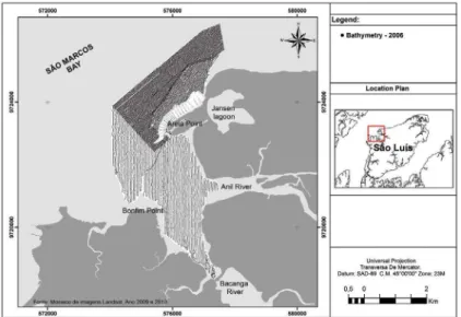
São Luís Island (02°24’09” to 02°46’13” S and 44°01’20” to 44°29’47” W) is bordered by the São Marcos Bay to the west, São José Bay to the east, Mosquito Straights to the south and the Atlantic Ocean to the north. Four municipalities are located on the island: São Luís, São José de Ribamar, Paço do Lumiar and Raposa. The study area (São Luís tidal inlet) is located in the city of São Luís and extends from Guia Point to Areia Point, encompassing the mouths of the Bacanga and Anil rivers on the eastern coast of São Marcos Bay. The area selected for the analysis of siltation dynamics is bounded by Areia Point to the north, the Bacanga dam to the south and Bonim Point to the west (Figure 1). The choice of this area was based on the availability of bathymetric data for the time period selected and to the fact that it is the area in the tidal inlet where the siltation process is most accentuated.
Figure 1. Map of study area.
Figure 2. Bathymetric proiles at the São Luís tidal inlet and adjacent coastal areas surveyed by VALE in 2006.
patterns in the access channel to the Port of São Luís (tidal inlet). The procedure consisted of designing a conceptual model based on an analysis of nautical charts of the Brazilian Navy’s Hydrography and Navigation Board (DHN) from the years 1947 and 1966, as well as bathymetric surveys conducted by VALE in 2006 (Figure 2), focused on the Study of the Environmental Impact for Implementation of Coastal Water Containment and Dredging of the São Luís Harbor Navigation Channel, and aerial images taken at different tidal levels during the year 2011.
Due to the large tidal range found in the study area, the effects of meteorological tides are proportionally small, and can therefore be neglected in this evaluation.
Thus, tide gauge data of São Luís (formerly the Port of São Luís), located at the UTM coordinates E576751, N9720412 SAD69, were used to make bathymetric corrections and indicate the dimension of the tide for different images of 2011. These data refer to its constituent or harmonic components. Through harmonic constituents, using numerical formulas, the tide levels at each of the locations can be predicted. These constituents were obtained from the harmonic analysis of tidal measurement data developed by the Marine Studies Foundation of Brazil (FEMAR).
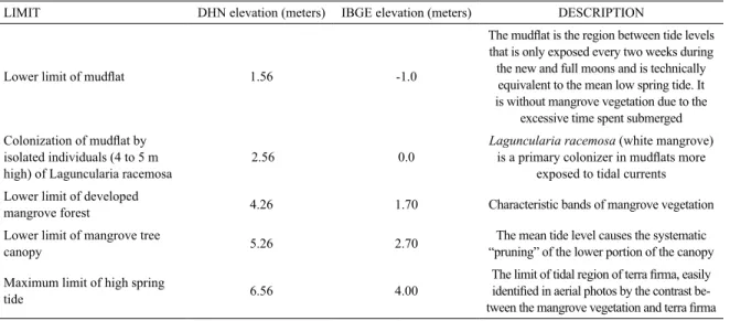
Table 1. Approximate elevation of landscape features in the region between tides used to complete the digital terrain model of the estuaries of the Anil and Bacanga rivers. The IBGE elevation refers to the Imbituba national elevation datum of the Brazilian Institute of Geography (IBGE).
LIMIT DHN elevation (meters) IBGE elevation (meters) DESCRIPTION
Lower limit of mudlat 1.56 -1.0
The mudlat is the region between tide levels
that is only exposed every two weeks during the new and full moons and is technically equivalent to the mean low spring tide. It is without mangrove vegetation due to the
excessive time spent submerged
Colonization of mudlat by
isolated individuals (4 to 5 m high) of Laguncularia racemosa
2.56 0.0
Laguncularia racemosa (white mangrove)
is a primary colonizer in mudlats more
exposed to tidal currents Lower limit of developed
mangrove forest 4.26 1.70 Characteristic bands of mangrove vegetation
Lower limit of mangrove tree
canopy 5.26 2.70
The mean tide level causes the systematic “pruning” of the lower portion of the canopy
Maximum limit of high spring
tide 6.56 4.00
The limit of tidal region of terra irma, easily identiied in aerial photos by the contrast be
-tween the mangrove vegetation and terra irma
datum SAD69). The isobaths and limits of sandbanks and mud were vectored and the resulting digitized lines were converted into iles with altimetric points, and in the sequence into an elevation 3D grid, which was used to calculate siltation and erosion volumes. The 2011 aerial photos do not have elevation data, therefore the water level in photos, taken at different time on the same day, was taken as a reference datum, using the predicted water level from the tide table. The altimetry vectoring of the georeferenced raster images was performed using the Geographic Information System (GIS) software SPRING 5.0.
The original objective of DHN charts was to provide reliable mapping of navigation channels (restricted area of the tidal inlet) and therefore, the charts do not detail altimetric data of sandbanks. Thus, a speciic method was adopted to enrich the digital model of the terrain, which consisted of the altimetric georeferencing of the limits of notable features, such as the mangrove forest and plains of adjacent mud banks (mudlats), as well as the maximum and minimum limits of spring tides (Table 1).
The evolution of silted volume in the study area was obtained from the data processing software SURFER 10 (Golden Software), by the interpolation method called Natural Neighbor. This interpolation method was used because it presented a good overall accuracy and a better idelity to the original data when compared to other methods. The density of points used for the interpolation was 3,703, 3,281, 69,052 and 37,147 for the years 1947, 1966, 2006 and 2011, respectively.
The estimated siltation volume was deined based on the arithmetic mean of Simpson’s method, Simpson’s 3/8 method and the trapezoidal rule (ODRESKI et al.,
2003). The SURFER 10 tool known as Blank, was used to deine similar intervals among different bathymetric maps, thus minimizing possible errors during volume and embankment calculations. The same procedure was applied in the comparison of different period Digital Elevation Models (DEM), in order to evaluate spatial and temporal patterns of the erosion and sedimentation processes.
Thus, the region depicted for the preparation of volume calculations included the limits established by Areia Point, to the north, Bacanga dam, to the south, and Bonim Point, to the west, constituting a total area of 8.5 km2.
The reduction of water surface acreage of the São Luis tidal inlet between 1966 and 2011 was also employed as an indicator of the predominant siltation process. The evaluation of the acreage changes was performed with the software SPRING 5.0.
RESULTS
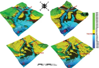
the channel of the Anil river (Figures 3A and 3B). Along the main channel, depths of up to 11.0 m were observed in this period, and also a volume estimated at 5.0x10⁶ m3 for
areas below the elevation of 0.0 m DHN, which are areas always submerged in the low tides of syzygy.
Bathymetric surveys undertaken in 2006 deined drastic geomorphological changes in the study area. The presence of two different channels with access to the bay can be observed in low tide conditions (Figure 3C), with depths that prevent navigation at any point in the tidal cycle. The results indicate volumes of approximately 110,000 m3 for areas below 0.0 m DHN.
Analyses undertaken in 2011 presented a geomorpholog-ical coniguration of the study area, similar to that observed in 2006 (Figure 3D), but with changes mainly in 4.0 and 6.5 m DHN elevation class. In this altimetric interval, a loss of water volume around 4.8x10⁶ m3 was estimated, while in the
lower levels the results presented were very close to these. These results show the dynamics of the siltation process in the area investigated, with depositions located initially on the lower levels. In sequence, these depositions achieved the highest levels. It is noteworthy that both in 2006 and in 2011, maximum depths (3.0 m) were observed along the channel.
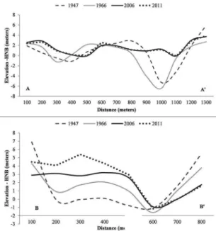
The changes in this 64-year period were also observed through two bathymetric proiles in the region (Figure 4), framing the area of the mouth (A and A’) and a segment near the mouth of Anil river (B and B’).
The proile analysis in the São Luís tidal inlet (A and A’) signals a signiicant siltation in the region, with maximum depths reduced from 6.0 m to near 0.0 m between 1947
Figure 3. Bathymetry maps of São Luís tidal inlet, in the period 1947 (A), 1966 (B), 2006 (C) and 2011 (D). A - A’ and B - B’ indicate the
bathymetric proile in the area.
and 2011. The morphology indicates the presence of a deep channel on the right bank in the period from 1947 to 1966. However, considering the analyses of 2006 and 2011, there was a pronounced sedimentary ill in the area, which made the presence of another channel on the left bank more evident. However, both had little substantial depths if compared to previous morphological conditions.
The proile made at the mouth of Anil river (B and B’) also indicated a sedimentary illing process and the maintenance of the channel on the right bank was observed. Noteworthy is the signiicant morphological change on the left bank of the mouth of the Anil river, also in the period from 2006 to 2011 (a period of only 5 years).
The analysis of the spatial and temporal dynamics of erosion and deposition processes in the São Luis tidal inlet employed the bathymetry differences observed in the 1947 to 2006 period (Figure 5). Between 1947 and 1966 there was localized deposition of up to +2 m. However, the erosion was predominant, especially in the main channel area, with bottom depth reduction of up to - 4 m. In the same period the average depth of the Sao Luis tidal inlet increased from 3.03 to 3.70 m.
The largest sedimentation rates were observed between 1966 and 2006, and were spread over the whole main channel. Deltas formed from tidal currents on looding tides also developed in this period.
Table 2. Water volumes below 6.5 m DHN elevation (4 m IBGE), which represents the maximum high tide limit in the São Luís tidal inlet.
YEAR
VOLUME
Below maximum high tide elevation (106 m3)
Below lowest mangrove elevation limit (106 m3)
1947 35.7 22.7
1966 33.9 20.0
2006 29.4 13.1
2011 27.2 12.3
Figure 4. Bathymetric proile in the São Luís tidal inlet (A and A') and
for the estuary of the Anil river (B and B') in the years 1947, 1966,
2006 and 2011.
Figure 5. Synthesis of the siltation and erosion processes at the Sao Luis Tidal inlet from 1947 to 2011. (A) Period from 1947 to 1966 with 1966 isobaths superimposed. (B) Period from 1966 to 2006 with 2006 isobaths superimposed. (C) Period from 2006 to 2011 with 2011 isobaths superimposed.
The predominance of deposition over erosion observed in the 1966 to 2006 period, can be correlated with several anthropic interventions on the sedimentation balance of the Sao Luis tidal inlet, such as the construction of the Bacanga dam in 1970 and several other land reclamation projects associated with urban expansion.
The human interventions on the tidal inlet increased the sediment deposition rate, which in turn would reduce
the tidal prism volume (and associated tidal currents), and further accelerate the deposition of sediments.
In the period between 2006 and 2011 the deposition and erosion processes were less intense in the lower elevations, as evidenced by the occurrence of no change areas in Figure 5. However, at higher elevations in the intertidal zone deposition greater than 2 m was observed.
The evaluation of the results based on the geomorphological evolution of the area from 1947 to over 11 signals a signiicant loss in water volume, which would occupy the space between the maximum high tide (6.5 m DHN) and the bottom of an area of approximately 8.5 km2, including the mouths of the
Anil and Bacanga rivers. Estimates indicated a decrease from 35.7x10⁶ m3 in 1947 to 27.2x10⁶ m3 in 2011,
The analysis of the lower limit of the mangrove forest (4.4 m DHN) indicated a loss of 46% of water volume in the study area, with values changing from 22.7x10⁶ m3 to
12.3x10⁶ m3 between 1947 and 2011, respectively.
Anthropic interventions, represented by dam construction, mangrove loss and land reclamation projects, were the main cause behind the tidal prism reduction in the estuarine portions of the Anil and Bacanga rivers.
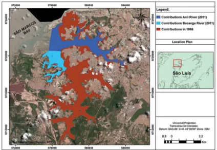
Figure 6 shows the extension of acreage reduction of intertidal areas contributing to the daily tidal prism in the estuaries of the Anil and Bacanga Rivers, either by dam construction or land reclamation of mangrove forests. The areas lost between 1966 and 2011 are shown in red. The remaining contribution areas are shown in light (Bacanga estuary) and dark (Anil estuary) blue colors.
The original intertidal zone area was estimated at 40.6 km2 in 1966. In 2011 the total remaining area was
of 13.23 km2, with 9.11 km2 and 4.12 km2 on the Anil and
Bacanga rivers, respectively. The total loss of intertidal area between 1966 and 2011 was 23.36 km2.
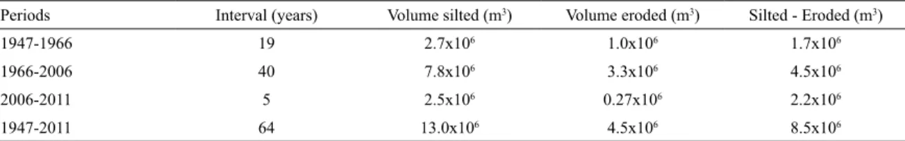
Estimates of silted and eroded volume for the 64-year period in the São Luís tidal inlet are around 13.0x10⁶
m3 and 4.5 x 10⁶ m3, respectively. This resulted in a
sedimentary illing process of approximately 8.5 x 10 m3
(Table 3).
The assessment signals the intensiication of the process over 64 years of analysis, a silted volume estimated at 2.7 x 10⁶ m3 being observed, for example,
between 1947 and 1966 (a 19-year interval), while in
Figure 6. Reduction of the estuarine water body acreage contributing to the original tidal prism at the estuary of Bacanga and Anil Rivers, for the period between 1966 and 2011.
only 5 years, considering the period 2006-2011, the silted volume was 2.5 x 10⁶ m3, the process being concentrated at
higher elevations. Dividing the total silted volume by the area covered by the surveys (8.5 km2), the result is a value
that can also be expressed as 1.0 m, which corresponds to the thickness of the sedimentary deposit (assuming a uniform deposition across the area). The division of the thickness of the sedimentary deposit by the time elapsed (1947-2011) indicated a sedimentation rate in the São Luís tidal inlet of 1.6 cm.year-1.
DISCUSSION
The analysis of the silting process in the São Luís tidal inlet brings to light an evolution that occurred initially in the channel sections (never exposed at low tide) that subsequently affected the intertidal zone. This information becomes important as it describes a sedimentary illing process which was initially perceived only by those who sailed the channels but which went unnoticed by others who observed only the morphological patterns on sandbanks exposed during low tide.
CARVALHO et al. (2000) stated that, in reservoirs that go through a sedimentary illing process, the visible siltation is usually the smallest portion of the deposit.
Table 3. Estimates of silted and eroded sediment volumes for the study area.
Periods Interval (years) Volume silted (m3) Volume eroded (m3) Silted - Eroded (m3)
1947-1966 19 2.7x10⁶ 1.0x10⁶ 1.7x10⁶
1966-2006 40 7.8x10⁶ 3.3x10⁶ 4.5x10⁶
2006-2011 5 2.5x10⁶ 0.27x10⁶ 2.2x10⁶
1947-2011 64 13.0x10⁶ 4.5x10⁶ 8.5x10⁶
had its coastal processes modiied by it. This imbalance coincided with certain interventions that have become common and of constant effect in the Anil and Bacanga river basins, such as the construction of the Bacanga dam, land reclamation projects for the construction of roads and the expansion of neighborhoods, such as the Bacanga urban park located near the historic center of São Luís.
According to LIMA (2007), interruptions in the outlow of rivers alter circulation and sedimentation patterns in their estuaries, leading to a deicit of sediments in the coastal zone, greater saline intrusion, spatial reorganization of the different ecological zones and the growth of sandbars. The authors state that the closure of inlets due to the growth of sandbars has been occurring frequently along the coast of the state of Bahia (Brazil), causing a reduction in the critical section of estuaries (reduction in the inlet) and possibly the loss of luvial competence.
A barrier has also been created in the São Luís tidal inlet caused by the string of sandbanks at Areia Point, which has advanced 400 meters toward Bonim Point in the past 30 years. The depositing of sand by the action of waves and conditions that are unfavorable to the free low of the tide has made the bed of the channel increasingly shallow.
WRIGHT and SCHOELLHAMER (2004) also highlighted anthropic activities as primarily responsible for the change in the sediment balance of the Sacramento River, California. JAFFE et al. (2007) highlighted activities such as urbanization, agriculture and cattle grazing as major contributors to the increased sediment load in San Pablo Bay.
The result of the silting process over 64 years was estimated at 8.5 x 10⁶ m3, which represents, considering
the area and the period investigated, a sedimentary illing process of around 1.6 cm.year-1. Following this same line
of argument, ODRESKI et al. (2003) found higher values in Antonina Bay (2.6 cm.year-1) - an area of 25 km2 - from the
analysis of a period of 74 years.
SAITO et al. (2001) reported values of up to 0.98 cm.year-1 for the sedimentation rate in the estuarine system
of Cananéia-Iguape, a value smaller than that obtained in this study. In the Santos estuary, FIGUEIRA et al. (2004)
estimated values ranging from 0.16 to 0.54 cm.year-1. In
the Guanabara Bay, sedimentation rates of 0.89 cm.year-1
were observed (OLIVEIRA et al., 2004). MARTÍNEZ et al. (2011), estimated rates of approximately 0.60 cm.year-1 in
studies conducted in San Simón Bay.
The higher values obtained in the São Luís tidal inlet, when compared to those recorded in the literature, demonstrate how intense sedimentation processes are in the region, calling for corrective actions that will allow the maintenance of the main channel besides the monitoring of a continuous area.
It is noteworthy that the anthropic activities that once interfered in the area of basins have been stabilized in recent years, especially those related to land use and occupation. Thus, practically no contributions are assumed for the current period regarding sediment input coming from the drainage basin, meaning that current contributions derive mainly from longshore and transportation by lood tidal currents of sediment input into the study area, promoting deposition since there has been a dramatic decrease in the low of the Anil and Bacanga rivers in recent decades, altering the sediment balance in the sector investigated.
In Chesapeake Bay (east coast of the United States), the sedimentation rate was estimated at 0.8 cm.year-1 for the
region of the tidal inlet, the origin of the sediments being marine (OFFICER et al., 1984), as evidenced in this study.
LIMA et al. (2011) pointed out that in the last 10 years the Santa Helena dam (Bahia-Brazil) has contributed to the maintenance of the estuary of the Jacuípe river due to artiicially released water discharge peaks, with the capacity to erode the sediments and to help unblocking the channel.
The rivers with extensive river basins and considerable rainfall transport a large volume of sediments to their estuaries, illing them quickly. However, for the discharges exceeding 200,000 m3.s-1 from the Amazon river, it appears
that the sediments are currently being released directly into the sea, with little silting at the mouth (0.1 cm.year-1),
whereas from the inner continental shelf the rate is of 60 cm.year-1 (DUKAT; KUEHL, 1995). On the outer shelf,
the rate is very high, ranging from 5-15 m.year-1 (KUEHL
maintaining the low of inland water bodies to avoid illing the channels of their estuarine systems.
In the case of the São Luís tidal inlet, no contributions from the Bacanga dam for the excavation of deposited sediment were observed. This can be explained as being due to the decrease of luvial competence, and hence to the decrease in the low arising from the artiicial discharge. It is also the result of an intense urbanization process that occurred in the area and the irregularity of the opening of the loodgates, along with existing mechanical problems in their structure that prevented their complete opening.
The evaluation of the results showed intense and advanced sedimentary illing processes in the São Luís tidal inlet, at rates proportionately higher than those found in other estuaries, calling for corrective actions and the implementation of coastal management policies for this area. Sedimentation processes have become very common on the Brazilian coast with the consequent loss of several estuarine systems (LESSA, 2006).
The evaluation of the sedimentation dynamics in the São Luís tidal inlet showed that the deposited volume has intensiied over 64 years of monitoring.
The analysis of the morphological bottom dynamics from 1947 to 2011 indicated transformations represented mainly by the increase in the number of areas above 0m DHN and by morphological changes in navigation channels.
Therefore, with the urban development foreseen for the historical center of São Luís city, the revitalization of tourism, the increase in port activities and the considerable interest in the real estate development of the coastal zone, greater interaction is needed with research institutions for the establishment of land use policies and the rational occupation of land in fragile ecosystems such as estuaries and the coastal zone, organizing or preventing activities near the coast to ensure the stability of the natural balance of such areas.
REFERENCES
ALBINO, J.; PAIVA, D. S.; MACHADO, G. M. Geomorfologia, tipo -logia, vulnerabilidade erosiva e ocupação urbana das praias do lito-ral do Espírito Santo, Brasil. Geografares, v. 2, n. 2, p. 63-69, 2001. ARAÚJO, M. C. B.; SOUZA, S. T.; CHAGAS, A. C. O.; BARBO-SA, S. C. T.; COSTA, M. F. Análise da ocupação urbana das praias de Pernambuco, Brasil. Rev. Gest. Cost. Integ., v. 7, n. 2, p. 97-104, 2007.
BOYD, R.; DALRYMPLE, R. W.; ZAITLIN, B. A. Classiication
of clastic coastal depositional environments. Sediment. Geol., v. 80, n. 3/4, 139-150, 1992.
CARVALHO, N. O.; FILIZOLA JÚNIOR, N. P.; SANTOS, P. M.
C.; LIMA, J. E. F. W. Guia de avaliação de assoreamento de reservatórios. Brasília: ANEEL, 2000. 140 p.
COWELL, P. J.; THOM, B. G. Morphodynamics of coastal evolu-tion. In: CARTER, R. W. G.; WOODROFFE, C. D. Coastal Evolution, Late Quaternary Shoreline Morphodynamics. Cam-bridge: Cambridge University Press, 1997. p. 33-86.
DUKAT, D. A.; KUEHL, S. A. Non-steady-state 210Pb lux and the
use of 228Ra/226Ra as a geochronometer on the Amazon
conti-nental shelf. Mar. Geol., v. 125, n. 3/4, p. 329-350, 1995. FAN, H.; HUANG, H.; ZENG, T. Impacts of anthropogenic
ac-tivity on the recent evolution of the Huanghe (Yellow) River delta. J. Coastal. Res., v. 22, n. 4, p. 919-929, 2006.
FIGUEIRA, R. C. L.; TESSLER, M. G.; MAHIQUES, M. M.; FUKUMOTO, M. M.; GOYA, S. C. Sedimentação recente e níveis de metais pesados em testemunhos do estuário santista,
São Paulo, Brasil. Anais do IV Congresso de Pesquisas Am -bientais e Saúde. Santos, 2004. p. 73-76.
FRAGOSO JÚNIOR, C. R.; BUARQUE, D. C.; TUCCI, C. E. M. Uma avaliação integrada do assoreamento e da poluição urba-na sobre a qualidade da água urba-na Embocadura Estuariurba-na de São Luís MA. In: II Simpósio de Recursos Hídricos do Sul-Sudes-te, 2008, Rio de Janeiro. Anais do II Simpósio de Recursos Hídricos do Sul-Sudeste. Porto Alegre: ABRH, 2008.
JAFFE, B. E.; SMITH, R. E.; FOXGROVER, A. C. Anthropo
-genic inluence on sedimentation and intertidal mudlat change
in San Pablo Bay, California: 1856-1983. Estuar. Coast. Shelf Sci.,v. 73, n. 1/2, p. 175-187, 2007.
KUEHL S. A.; DEMASTER, D. J.; NITTROUER, C. A. Nature of sediment accumulation on the Amazon continental shelf. Cont. Shelf Res., v. 6, n. 1/2, p. 209-225, 1986.
LANDIM, P. M. B. Introdução aos métodos de estimação espacial para confecção de mapas. Rio Claro: UNESP, 2000. 20 p. LESSA, G. C. Brazilian coastal bays: large estuaries in a regressive
coast. In: ÂNGULO, R.; KLEIN, H.; SOUZA, C. (Eds.). 3rd
IGCP 495 Meeting.BalneárioCamboriú, Brazil. Proceedings, 2006. p. 1-4.
LIMA, G.M.P., Caracterização Sedimentológica e dos Padrões de Circulação e Mistura do Estuário do Rio Jacuípe - Lito-ral Norte do Estado da Bahia. Dissertação - INSTITUTO DE GEOCIÊNCIAS (Mestrado em Geologia), Universi-dade Federal da Bahia, 2007.http://www.pggeologia.ufba. br/v1/index.php/biblioteca-digital/dissertacoes/marinha- -costeira-e-sedimentar-/277-geraldo-marcelo-pereira--lima-2007
LIMA, G. M. P.; VILAS BOAS, G. S.; COSTA, A. B.; ARGOLLO,
R. M. Taxas de sedimentação recentes provenientes dos mé-todos Cs137 e Pb210 e estimativa de preenchimento do estuário
Jacuípe, Bahia, Brasil. Rev. Bras.Geociênc., v. 41, n. 1, p. 44-55, 2011.
LIMA, G. M. P.; LESSA, G. C.; FRANKLIN, T. S. Avaliação dos impactos da barragem de Santa Helena no trecho estuarino do rio Jacuípe, litoral norte da Bahia - Brasil.Quat. Environ. Geosci. v. 02, n. 1, p. 40-54, 2010.
MARTÍNEZ, G. M.; PÉREZ-ARLUCEA, M.;
GONZÁLEZ-VILLANUEVA, R.; CAMPOS, A. O. Anthropogenic inlu -ence on the Holocene sedimentation process along the Atlan-tic coast of Galicia (NW Iberian Peninsula). J. Coastal. Res., v. 64, p. 1788-1792, 2011.
ODRESKI, L. L. R.; SOARES, C. R.; ANGULO, R. J.; ZEM,
R. C. Taxas de assoreamento e a inluência antrópica no con -trole da sedimentação da Baía de Antonina, Paraná. Bol. Par. Geoc., v. 53, p. 7-12, 2003.
OFFICER, C. B.; LYNCH, D. R.; SETLOCK, G. H.; HELZ, G. R. Recent Sedimentation Rates in Chesapeake Bay. In:
KEN-NEDY, V. S. (Ed.). The Estuary as a Filter. New York: Acade -mic Press, 1984. p. 131-157.
OLIVEIRA, G. H. R.; PATCHINEELAM, T. C. S; PATCHI
-NEELAM, S. M. Validação do método de geocronologia de
210Pb por espectrometria gama utilizando o detector coaxial
de GE ultrapuro do Departamento de Geoquímica da UFF.
Anais do II Simpósio Brasileiro de Oceanograia. São Paulo,
2004.
SAITO, R. T.; FIGUEIRA, R. C. L.; TESSLER, M. G.; CUNHA, I. I. L. 210Pb and 137Cs geochronologies in the Cananéia--Iguape estuary (São Paulo, Brazil). J. Radioanal. Nucl. Chem., v. 249, n. 1, p. 257-261, 2001.
SHI, J.; LI, G.; WANG, P. Anthropogenic inluences on the tidal
prism and water exchanges in Jiaozhou Bay, Qingdao, China. J. Coastal. Res., v. 27, n. 1, p. 57-72, 2011.
SOUZA, C. R. G. Coastal erosion and the coastal zone manage-ment challenges in Brazil. J. Integr. Coast. Zone Manage., vl. 9, n. 1, p. 17-37, 2009.
WOODROFFE, C. D. The natural resilience of coastal systems: primary concepts. In: MCFADDEN, L.;
PENNING-ROW-SELL, E.; NICHOLLS, R. J. (Eds.). Managing Coastal Vul -nerability. Amsterdam: Elsevier, 2007. p. 45-60.
WRIGHT, L. D.; THOM, B. G. Coastal depositional landforms: a mor-phodynamic approach. Prog. Phys. Geog., v. 1, p. 412-459, 1977. WRIGHT, S. A.; SCHOELLHAMER, D. H. Trends in the