www.ann-geophys.net/27/3155/2009/
© Author(s) 2009. This work is distributed under the Creative Commons Attribution 3.0 License.
Annales
Geophysicae
The potential of the synergistic use of passive and active remote
sensing measurements for the validation of a regional dust model
V. Amiridis1, M. Kafatos2, C. Perez3, S. Kazadzis4,8, E. Gerasopoulos4, R. E. Mamouri5, A. Papayannis5, P. Kokkalis5, E. Giannakaki6, S. Basart3, I. Daglis1, and C. Zerefos7
1Institute for Space Applications and Remote Sensing, National Observatory of Athens, Athens, Greece 2Center of Excellence in Earth Observing, Schmid College of Science, Chapman University, California, USA 3Barcelona Supercomputing Center-Centro Nacional de Supercomputaci´on (BSC-CNS), Earth Sciences Department, Barcelona, Spain
4Institute of Environmental Research and Sustainable Development, National Observatory of Athens, Athens, Greece 5Laboratory of Lasers and Applications, National Technical University of Athens, Athens, Greece
6Laboratory of Atmospheric Physics, Aristotle University of Thessaloniki, Thessaloniki, Greece 7Laboratory of Climatology, University of Athens, Athens, Greece
8Finnish Meteorological Institute, Climate Change Unit, Helsinki, Finland
Received: 30 March 2009 – Revised: 23 July 2009 – Accepted: 11 August 2009 – Published: 12 August 2009
Abstract. A long-lasting Saharan dust event affected Eu-rope on 18–23 May 2008. Dust was present in the free troposphere over Greece, in height ranges between the sur-face and approximately 4–5 km above sea level. The event was monitored by ground-based CIMEL sunphotometric and multi-wavelength combined backscatter/Raman lidar mea-surements over Athens, Greece. The dust event had the maxi-mum of its intensity on 20 May. Three-dimensional dust spa-tial distribution over Greece on that day is presented through satellite synergy of passive and active remote sensing using MODIS and CALIPSO data, respectively. For the period un-der study, the ground-based measurements are used to char-acterize the dust event and evaluate the latest version of the BSC Dust Regional Atmospheric Modeling (BSC-DREAM) system. Comparisons of modeled and measured aerosol opti-cal depths over Athens show that the Saharan dust outbreak is fairly well captured by BSC-DREAM simulations. Evalua-tion of BSC-DREAM using Raman lidar measurements on 20 May shows that the model consistently reproduces the dust vertical distribution over Athens.
Keywords. Atmospheric composition and structure (Aerosols and particles; Pollution – urban and regional; Instruments and techniques)
Correspondence to:V. Amiridis ([email protected])
1 Introduction
The Mediterranean area is strongly affected by the presence of desert dust due to its proximity to North Africa. Limita-tions on the description of the dust cycle are mainly related to the lack of enough dense and regular measurements, but also due to the incomplete understanding of dust processes such as production, transport, physical and chemical evolu-tion, optical properties and removal of dust (Sokolik et al., 2001). Several regional models for simulation and prediction of the atmospheric dust cycle have been developed over the past decade (e.g., Kallos et al., 1997; Nickovic et al., 2001). These models are essential to complement dust-related ob-servations and to understand the dust cycle. In this context, the BSC Dust Regional Atmospheric Model (BSC-DREAM) (Nickovic et al., 2001; Perez et al., 2006a, b) has reached a level of delivering reliable operational dust forecasts (http:// www.bsc.es/projects/earthscience/DREAM/) capable of pdicting all the major dust events over the Mediterranean re-gion. However, the current operational version still has large development possibilities.
information on the vertical structure seem the most appropri-ate tools for such model evaluation studies.
Sun photometry, with variable measurement approaches has been developed in recent years to deduce the variabil-ity of critical atmospheric aerosol properties. The AErosol RObotic NETwork (AERONET) program is a federated re-mote sensing network of well-calibrated sun photometers and radiometers located at over 200 sites covering all major tropospheric aerosol regimes around the world (Holben et al., 1998). AERONET stations provide columnar aerosol optical parameter information (aerosol optical depth, size distribu-tion, single scattering albedo etc.) through direct measure-ments and inversion techniques. These data constitute a high-quality, ground-based aerosol climatology and, as such, have been widely used for aerosol process studies, as well as for evaluation and validation of model simulations. However, it should be noted that most inversion-based retrieval products have not yet been systematically validated. In addition, no information is provided regarding the vertical distribution of aerosol properties, which is a limitation.
Lidar is the only technique that provides high resolu-tion vertical profiling of aerosols. In recent years, Raman Lidars and micro-pulse Lidars (MPL) have been increas-ingly used to automatically and routinely retrieve profiles of aerosol backscattering and extinction. The European Aerosol Research Lidar NETwork (EARLINET) was established in 2000 to characterize the horizontal, vertical, and temporal distribution of aerosols on a European scale (B¨osenberg et al., 2003). At present, EARLINET consists of 25 stations, including backscatter lidar stations, 16 combined backscat-ter/Raman lidar stations and 8 multi-wavelength Raman li-dar stations which are used to retrieve aerosol microphysical properties.
Lidar techniques play an increasing role in future Earth ob-servation strategies. CALIOP (Cloud-Aerosol LIdar with Or-thogonal Polarization) onboard the NASA/CNRS CALIPSO satellite provides a first opportunity to study in detail the per-formance and the scientific value of a space-borne aerosol lidar during a long term mission. CALIOP lidar onboard CALIPSO, provides information on the vertical distribution of aerosols and clouds as well as on their optical proper-ties over the globe with unprecedented spatial resolution (Winker et al., 2006). However, CALIPSO observations pro-vide global, but snapshot-like view of aerosol vertical dis-tributions. Only combined studies with ground-based lidars together with transport modeling techniques will allow a full exploitation of these data for a detailed description of the temporal and spatial aerosol distribution and evolution on a global scale. Active and passive remote sensing satellite data synergy on the other hand can improve aerosol charac-terization and speciation. CALIPSO active remote sensing data can be used in conjunction with the MODerate resolu-tion Imaging Spectroradiometer (MODIS) (e.g. Remer et al., 2008) to better indentify and characterize aerosol distribu-tions and properties.
In this study, the spatial and temporal evolution, optical properties and vertical structure of the Saharan dust plume that affected Europe between 18–23 May 2008 as estimated by the BSC-DREAM dust modeling system are validated over Greece using synergistic passive and active remote sens-ing techniques. First, we describe the Saharan dust out-break over Greece using the latest updated version of BSC-DREAM and satellite imagery from SEAWIFS. The three-dimensional structure of dust outflow over Greece is then presented as retrieved by MODIS and CALIPSO aerosol data for a selected day when dust load over Greece showed max-imum values. Qualitative evaluation of the evolution of the modeled dust horizontal and vertical structure is performed. Satellite/ground-based data and modeling results are used to identify cases with pure dust presence in the free tropo-sphere over Athens. Then, the columnar and vertical evo-lution and the optical properties of the dust plume mea-sured with ground-based instrumentation are analysed to-gether with BSC-DREAM dust modeling estimations. The main objective of the study is to present and formulate po-tential methods to validate a dust modeling system using new and well-known active and passive remote sensing tech-niques from space and ground. The driving force behind this study is the fact that aerosols over the Eastern Mediter-ranean region originate from different sources, including a marine component (mainly sea spray), a mineral dust com-ponent mainly due to the proximity to Saharan desert dust and an anthropogenic component (local and long-range pol-lution) (Mihalopoulos et al., 1997; Papayannis et al., 2005, 2008; Formenti et al., 2001; Lelieveld et al., 2002; Zerefos et al., 2002; Gerasopoulos et al., 2003; Balis et al., 2004; Amiridis et al., 2005, Kazadzis et al., 2007; Kalivitis et al., 2007; Fotiadi et al., 2006), demanding strong data synergy for aerosol speciation. After the identification of pure dust presence, model validation studies can become more quanti-tative and accurate.
2 Instrumentation and methods
2.1 CIMEL sunphotometer
2.2 Ground-based lidar system
The NTUA compact 6-wavelength Raman lidar system is based on a pulsed Nd:YAG laser emitting simultaneously at 355 nm, 532 nm and 1064 nm. The elastically backscat-tered lidar signals (at 355, 532 and 1064 nm), as well as those generated by Raman scattering by atmospheric N2and H20 (at 387, 607 and 407 nm, respectively) are simultane-ously recorded by photomultipliers (PMTs) and avalanche photodiode systems (APD), after the spectral separation of the returned lidar signals (Mamouri et al., 2009; Papayan-nis et al., 2005). The system is used to perform continuous measurements for the retrieval of the aerosol optical proper-ties over Athens inside the Planetary Boundary Layer (PBL) and the lower free troposphere. In the frame of the EAR-LINET and EAREAR-LINET-ASOS projects, the NTUA lidar sys-tem was quality assured by performing direct intercompar-isons, both at hardware (Matthias et al., 2004) and software level (B¨ockmann et al., 2004; Pappalardo et al. 2004). The lidar system of NTUA is located within 400 m distance from the CIMEL sunphotometer.
2.3 Satellite measurements
The Cloud–Aerosol Lidar and Infrared Pathfinder Satel-lite Observation (CALIPSO) mission (http://smsc.cnes.fr/ CALIPSO/), is an Earth Science observation mission that launched on 28 April 2006 and flies in nominal orbital al-titude of 705 km and an inclination of 98 degrees as part of a constellation of Earth-observing satellites known as the “A-train” (Hostetler et al., 2001). The CALIPSO mission pro-vides crucial lidar and passive sensors to obtain unique data on aerosol and cloud vertical structure and optical proper-ties. CALIPSO is an elastically backscattered lidar operating at 532 and 1064 nm, equipped with a depolarization channel at 532 nm, that provides high-resolution vertical profiles of aerosols and clouds (Winker et al., 2006). The Level 1 V2 (Version 2) attenuated backscatter and depolarization profile product is used in this paper.
Finally, the Moderate Resolution Imaging Spectro-Radiometer (MODIS) aerosol 5-min level-2 swaths (collec-tion 5) were retrieved through NASA’s Earth Observing Sys-tem Data Gateway. AOD values at 550 nm were extracted with an uncertainty of±0.05±0.15*AOD over land (Remer et al., 2008).
Summarizing, we have used a synergy of different re-mote sensing instruments and techniques to derive a vari-ety of dust aerosol optical properties. From measurements at the ground we have retrieved AOD, Angstrom parameters, aerosol size distribution and single scattering albedo and also lidar backscatter and extinction coefficient profiles at UV and visible wavelengths. In addition AOD, total attenuated backscatter coefficient aerosol profiles and images in the vis-ible have been retrieved from satellite sensors.
2.4 The BSC-DREAM model
DREAM (Nickovic et al., 2001) is a regional model designed to simulate and/or predict the atmospheric cycle of mineral dust aerosol. The Barcelona Supercomputing Center main-tains dust forecast operations with DREAM and conducts modelling research and developments for short-term predic-tion. During model integration, calculation of the surface dust injection fluxes is made over the model grid points de-clared as deserts. Once injected into the air, dust aerosol is driven by the atmospheric model variables: by turbulent pa-rameters in the early stage of the process when dust is lifted from the ground to the upper levels; by model winds in the later phases of the process when dust travels away from the sources; finally, by thermodynamic processes (atmospheric water phase changes producing clouds, rain and dust wet scavenging) of the atmospheric model and land cover fea-tures which provide wet and dry deposition of dust over the Earth surface.
One of the key components of the dust model is the treat-ment of the source terms in the concentration continuity equation. Failure to adequately simulate/predict the produc-tion phase of the dust cycle leads to wrong representaproduc-tion of all other dust processes in the model. Therefore, special attention is made to properly parameterize dust production phase. The dust emission parameterization in the model is controlled mainly by the following factors: type of soil, type of vegetation cover, soil moisture content, and surface atmo-spheric turbulence. In the model, grid points acting as desert dust sources are specified using arid and semiarid categories of the global USGS 1-km vegetation dataset. Another data participating in dust production calculations is the FAO 4-km global soil texture data set from which particle size pa-rameters are evaluated. The main general features of the last version of the model (Perez et al., 2006a) used in this study are listed below:
– Dust production scheme with introduced viscous sub-layer (Shao et al., 1993; Janjic, 1994)
– 8 particle size bin distribution.
– Soil wetness effects on dust production (Fecan et al., 1999)
– Dry deposition (Giorgi, 1986) and below cloud scav-enging.
– Horizontal and vertical advection, turbulent and lateral diffusion (Janjic, 1994) represented as for other scalars in the Eta/NCEP model.
– Dust radiative feedbacks on meteorology (P´erez et al., 2006a).
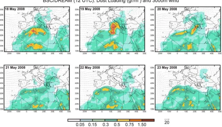
Fig. 1. Dust loading and 3000 m wind fields over Europe for the period 18–23 May 2008, as estimated by the BSC-DREAM model (12:00 UTC).
solar radiation are the most significant. Within each trans-port bin, dust is assumed to have time-invariant, sub-bin log-normal distribution employing the transport mode with mass median diameter of 2.524µm and geometric standard devi-ation 2.0. The analytic sub-bin distribution allows accurate prescription of physical and optical properties known to vary across the bin width.
The model at the starting day is run using “cold start” con-ditions, i.e., the zero-concentration initial state. The model needs about 2–3 days for spinning up and for establishing reliable dust concentration conditions. The cold start of the model was initiated on the 14 May 2008. The resolution is set to 50 km in the horizontal and to 24 layers extending up to ap-proximately 15 km in the vertical. Meteorological fields are initialized every 24 h and boundary conditions updated every 6 h with the NCEP/NCAR I global analysis (1 degree×1 de-gree resolution). The choice of 24-h re-initialization is used to avoid introducing large discontinuities in the simulation (in contrast to 48-h or 72 h) while letting the model develop its own dynamics and physics. The domain of simulation covers northern Africa, the Mediterranean Sea, and southern Europe (Fig. 1).
3 Results and discussion
3.1 Evolution of dust over Greece during 18–23 May 2008
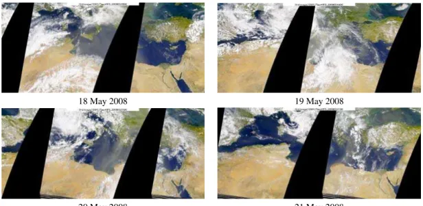
18 May 2008 19 May 2008
20 May 2008 21 May 2008
Fig. 2.SeaWIFS visible satellite images for 18, 19, 20 and 21 May 2008.
dust plume show very good agreement with the correspond-ing Seawifs visible satellite images (Fig. 2).
For 20 May, according to the model simulation (shown in Fig. 1), Greece was mostly affected by dust aerosols. In Fig. 3 we present satellite aerosol data from the MODIS and CALIPSO space-borne instruments. The AODs at 550 nm are plotted over Greece, taken by MODIS aerosol 5-min level-2 swaths (collection 5) at 09:55 UTC. Dust AOD val-ues for Greece on 20 May 2008 according to the model (shown in Fig. 1) range between 0.15–0.75 at 12:00 UTC. Concerning the qualitative performance of the model, the spatial patterns of the dust plume show that the AOD val-ues retrieved by MODIS at 550 nm are higher than AODs estimated by the model, and this is attributed to the con-tribution of the anthropogenic local pollution. This is ex-pected since model delivers AODs concerning only dust. In Fig. 3, the CALIPSO vertical cross section of the attenuated backscatter coefficient at 532 nm is superimposed for 20 May at 09:50 UTC. According to CALIPSO observations the dust presence in the vertical is extended to the free troposphere over Greece up to heights of 3000–5000 m. This argument is moreover supported by CALIPSO’s depolarization measure-ments at 532 nm (not shown here). The depolarization ratio on 20 May reached values in the range between 0.3–0.7 in-dicating the presence of dust particles in the free troposphere over Greece. Few white out regions in the Fig. 3 indicate CALIOP aerosol retrievals that were affected by clouds.
3.2 Characterization of the dust event using the CIMEL sunphotometer and NTUA’s lidar
To characterize the dust properties over Athens for 20 May 2008, ground-based sun photometric and combined
Fig. 3. Three-dimensional representation of dust evolution over Greece for 20 May 2008. Spatial distribution of AOD obtained at 550 nm by the MODIS sensor and CALIPSO cross section of the attenuated backscatter coefficient at 532 nm.
backscatter/Raman lidar measurements are used in this study. From the direct CIMEL sunphotometric measurements over Athens, the AOD at selected spectral channels is derived, following the well-known Beer-Bouguer-Langley law. The
˚
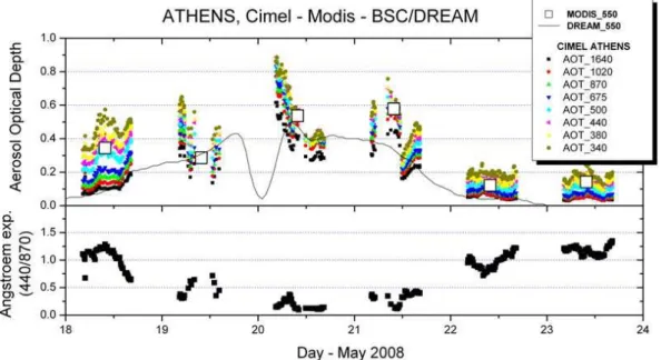
Fig. 4.Temporal evolution of the AOD at eight wavelengths over Athens for the period 18–23 May 2008 according to CIMEL sunphotometric measurements, MODIS AOD at 550 nm (white squares) and BSC-DREAM dust AOD at 550 nm (upper panel). Temporal evolution of the
˚
Angstr¨om exponent (440–870 nm) for the same time period (lower panel).
wavelengths an inversion algorithm (AERONET version 2 (Dubovik et al., 2002, 2006)) retrieves a large set of optical and microphysical aerosol parameters. In Fig. 4 we present the temporal evolution of the AOD and the ˚Ansgtr¨om ex-ponent (α)over the Athens AERONET site, as well as the MODIS AODs at 550 nm which are found to be in good agreement with CIMEL measurements. Additionally, BSC-DREAM AODs for dust are plotted, showing that the evolu-tion of the episode is well captured by the model. Figure 4 shows the quick arrival of the desert plume at Athens station (the AOD increases significantly from 18 May to 20 May). The highest AOD is registered on 20 May with a value of 0.8 (440 nm). The desert dust plume is also visible on 21 May, while the following days (22–23 May) show a clear weak-ening of the event as the desert plume quickly moved away, as shown by the AOD, which dropped back to background levels.
In Fig. 4 we can also observe the time series of the ˚
Ansgtr¨om exponent, which shows very low values (from zero to 0.5) for 19, 20 and 21 May, in inverse correspondence with the high AOD for desert aerosols. One of the charac-teristics of the desert dust episodes is the high variability shown by both parameters during each day. As can be seen in Fig. 4, on 19 May partial cloudiness is observed and some data were removed by the AERONET cloud-screening algorithm. On 20 May at 00:00 UTC, a strong dust layer is advected away from the observation location accounting for the sudden drop of the AOD. The analysis of the dust model maps at that time (not shown here) essentially explains this sudden drop. For the period between 18 and 22 May, the
mean daily Volume Size Distribution (not shown here but can be found on the AERONET web page: http://aeronet. gsfc.nasa.gov/cgi-bin/type one station opera v2 new?site= ATHENS-NOA\&nachal=2\&level=2\&place code=10) exhibit two modes, but the relative importance of the modes depends on the prevailing aerosol type: an accumulation or fine mode with particle radius below 0.6µm, and a coarse mode with particle radius between 0.6 and 15µm. In this case, obviously we expect a predominant coarse mode during desert dust conditions. The mode radii and volume concentrations were analyzed in order to characterize the aerosol dust evolution. The evolution of the desert dust is clear in the coarse mode fraction. The Volume Size Distribution exhibits well defined desert dust characteristics from 19 to 21 May with more predominant effects for 20 May when the volume concentration peaks varying from 0.9 to 1.6µm3/µm2with a mean of 1.4µm3/µm2.
Fig. 5.Time-height cross section of the lidar range corrected signal at 532 nm (arbitrary units) measured on 20 May 2008 over Athens.
this layer is located between the top of the PBL and approx-imately 5000 m. Given the BSC-DREAM simulations and CALIPSO’s depolarization ratio values presented above, this layer is completely attributed to Saharan dust aerosols ad-vected over Athens. High values of the backscatter signals within the PBL indicate the possibility of dust presence also in lower heights.
3.3 Validation of BSC-DREAM simulations
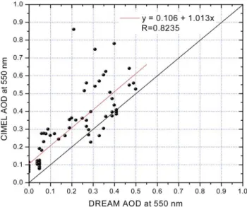
In our study, an attempt to validate BSC-DREAM model simulations is made using the ground-based passive and ac-tive remote sensing measurements presented previously. We use sunphotometric measurements for the complete period of the dust outbreak, while for the lidar case we focus on the case study of 20 May when dust load was clearly present over Athens and night-time Raman measurements were available. In Fig. 6, we present the AODs measured by CIMEL versus the dust AODs estimated by BSC-DREAM, for the period under study. BSC-DREAM delivers AODs at 550 nm and CIMEL at 500 nm. For a direct comparison, CIMEL AODs where converted from 500 to 550 nm using the ˚Angstr¨om exponent (440/870). The correlation coeffi-cient found to be of the order of 0.7, showing a quite good agreement between BSC-DREAM and CIMEL AODs. Tak-ing into account the urban pollution of Athens, the CIMEL AODs should reach higher values than the model estimations that account only for transported dust. Indeed, just taking the mean of (AODcimel–AODdream)of all measurements we can find an AOD equal with 0.10±0.07 that can be attributed to the mean anthropogenic contribution in AOD during the period of this event. For three cases during this event the an-thropogenic pollution contribution was found as high as 0.4 to 0.6.
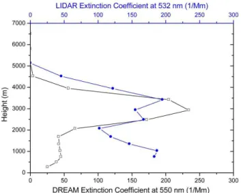
To further evaluate the model, we proceed with an in-tercomparison of modelled vertical profile of extinction at 550 nm with Raman lidar-derived vertical profile of extinc-tion at 532 nm for 20 August at 18:00 UTC, when correlative
Fig. 6. CIMEL versus BSC-DREAM AODs at 550 nm for dust cases observed within the period between 18–23 of May 2008.
Fig. 7. Comparison of extinction coefficient profile simulated by BSC-DREAM at 550 nm (only for dust) and observed by Raman lidar measurements at 532 nm over Athens, on 20 May 2008 at 18:00 UTC. Raman lidar signals were averaged between 17:25 and 18:38 UTC.
model follows well the vertical distribution of the dust layer for the free troposphere since it provides extinction coeffi-cients for dust particles only. Within the PBL, model esti-mates a dust contribution much lower than that of the free troposphere. The agreement between lidar and model re-sults in the free troposphere could be considered as excellent, keeping in mind that Raman lidar extinction retrieval uncer-tainties are of the order of 15–30%.
Model’s capability to estimate the dust layer geometrical and optical characteristics, is evaluated by the calculation of the center of mass and the AOD. The calculations are performed within the dust layer as estimated above (2067– 5135 m), in order to remove the anthropogenic effect. The center of mass (CM) altitude (zc)from the extinction is
cal-culated as follows (Mona et al., 2006):
zc = zt
R
zb
z·ext(z)dz
zt
R
zb
ext(z)dz
(1)
where ext(z)represents the extinction coefficient at 532 and 550 nm for lidar and the model respectively, whilezb and
zt represent the bottom (2067 m) and top (5135 m) height of
the dust layer. According to our calculations, the CM from the model is estimated at 3054 m while our lidar measure-ments locate CM at 3234 m. The difference of 180 m can be attributed to the extinction minimum observed with lidar at 3000 m, which is not predicted by the model. Specifically, maximum extinction coefficients reached 234 Mm−1 accord-ing to the model at 2933 m and 195 Mm−1at 3420 m accord-ing to lidar. Consideraccord-ing AODs within the dust layer, the
differences between the model (0.34) and lidar (0.36) are of the order of−6%. Our results indicate that generally, BSC-DREAM’s deviations from measured lidar geometrical and optical characteristics are within the error of lidar measure-ments and model’s performance for the presented Saharan dust outbreak could be considered excellent.
4 Summary and conclusions
The spatial and temporal evolution, optical properties and vertical structure of the Saharan dust plume that affected Eu-rope between 18–23 May 2008 were analyzed in detail over Greece using synergistic passive and active remote sensing techniques together with BSC-DREAM dust modeling simu-lations. The main results and conclusions are summarized as follows: Comparisons of modeled and measured aerosol op-tical depths over Athens show that the Saharan dust episode is well simulated by BSC-DREAM simulations, both spa-tially and temporarily. Direct comparison of CIMEL-BSC-DREAM AODs showed an agreement with a correlation co-efficient of the order of 0.8. Model vertical distribution esti-mations of the extinction coefficient are in very good agree-ment with Raman lidar measureagree-ments in the free troposphere of Athens on 20 May 2008. BSC-DREAM-lidar intercom-parisons of the geometrical and optical characteristics of dust were studied only in the height ranges where the data indi-cate the presence of dust particles. Following this approach, the model simulations of the layer thickness, bottom and top height, AOD and center of mass are in very good agree-ment with lidar ground-based measureagree-ments. The model showed better performance when compared with lidar mea-surements than those revealed from sunphotometric observa-tions. This is attributed to the fact that in lidar measurements the comparison of the extinction is feasible for selected at-mospheric layers in the free troposphere where dust prevails than aerosol particles of anthropogenic origin.
8.3 of OPERATIONAL PROGRAMME “COMPETITIVE-NESS” in the 3rd Community Support Programme.
Topical Editor F. D’Andrea thanks four anonymous referees for their help in evaluating this paper.
References
Amiridis V., Balis, D., Kazadzis S., Giannakaki, E., Papayannis, A., and Zerefos, C.: Four years aerosol observations with a Ra-man lidar at Thessaloniki, Greece, in the framework of Euro-pean Aerosol Research Lidar Network (EARLINET), J. Geo-phys. Res., 110, D21203, doi:10.1029/2005JD006190, 2005. Ansmann A., B¨osenberg, J., Chaikovsky, A., Comer´on, A.,
Eck-hardt, S., Eixmann, R., Freudenthaler, V., Ginoux, P., Komguem, L., Linn´e, H., M´arquez, M. ´A. L., Matthias, V., Mattis, I., Mitev, V., M¨uller, D., Music S., Nickovic, S., Pelon, J., Sauvage, L., Sobolewsky, Srivastava, M. K., Stohl, A., Torres, O., Vaughan, G., Wandinger, U., and Wiegner, M., Long-range transport of Saharan dust to northern Europe: The 11–16 October 2001 out-break observed with EARLINET, J. Geophys. Res., 108(D24), 4783, doi:10.1029/2003JD003757, 2003.
Ansmann, A., Wandinger, U., Riebesell, M., Weitkamp, C., and Michaelis, W.: Independent measurement of extinction and backscatter profiles in cirrus clouds by using a combined Raman elastic backscatter lidar, Appl. Optics, 31, 7113–7131, 1992. Balis, D. S., Amiridis, V., Zerefos, C., Kazantzidis, A., Kazadzis,
S., Bais, A. F., Meleti, C., Gerasopoulos, E., Papayannis, A., Matthias, V., Dier, H., and Andreae, M. O.: Study of the effect of different type of aerosols on UV-B radiation from measurements during EARLINET, Atmos. Chem. Phys., 4, 307–321, 2004, http://www.atmos-chem-phys.net/4/307/2004/.
Balis D., Amiridis, V., Nickovic, S., Papayannis, A., and Zerefos, C.: Optical properties of Saharan dust layers as detected by a Raman lidar at Thessaloniki, Greece, Geophys. Res. Lett., 31, L13104, doi:10.1029/2004GL019881, 2004.
B¨ockmann, C., Wandinger, U., Ansmann, A., B¨osenberg, J., Amiridis, V., Boselli, A., Delaval, A., De Tomasi, F., Frioud, M., Grigovov, I. V., Hagard, A., Iarlori, M., Komguem, L., Kreipl, S., Larcheveque, G., Matthias, V., Papayan-nis, A., Pappalardo, G., Rocadenbosch, F., Rodrigues, J. A., Schneider, J., Scherbakov, V., and Wieger, M.: Aerosol lidar intercomparison in the frame-work of the EARLINET project: 2. Aerosol backscatter algo-rithms, Appl. Optics, 43, 977–989, 2004.
B¨osenberg, J., Matthias, V., Amodeo, A., Amoiridis, V., Ansmann, A., et al.: EARLINET project: A European Aerosol Research Lidar Network, Max-Planck Institute (MPI), Final Report, 348, 1–250, 2003.
Dubovik, O., Holben, B. N., Eck, T. F., Smirnov, A., Kaufman, Y. J., King, M. D., Tanre, D., and Slutsker, I.: Variability of absorption and optical properties of key aerosol types observed in world-wide locations, J. Atmos. Sci., 59, 590–608, doi:10.1175/1520-0469, 2002.
Dubovik, O., Sinyuk, A., Lapyonok, T., Holben, B. N., Mishchenko, M., Yang, P., Eck, T. F., Volten, H., Mun˜oz, O., Veihelmann, B., van der Zande, W. J., Leon, J. F., Sorokin, M., and Slutsker, I.: Application of spheroid models to account for aerosol particle nonsphericity in remote sensing of desert dust, J. Geophys. Res., 111, D11208, doi:10.1029/2005JD006619, 2006.
Eck, T. F., Holben, B. N., Reid, J. S., Dubovik, O., Smirnov, A., O’Neill, N. T., Slutsker, I., and Kinne S.: The wavelength depen-dence of the optical depth of biomass burning, urban and desert dust aerosols, J. Geophys. Res., 104, 31333–31350, 1999. F´ecan, F., Marticorena, B., and Bergametti, G.: Parametrization of
the increase of the aeolian erosion threshold wind friction veloc-ity due to soil moisture for arid and semi-arid areas, Ann. Geo-phys., 17, 149–157, 1999,
http://www.ann-geophys.net/17/149/1999/.
Formenti, P., Andreae, M. O., Andreae, T. W., Galani, E., Vasaras, A., Zerefos, C., Amiridis, V., Orlovsky, L., Karnieli, A., Wendisch, M., Wex, H., Holben, B. N., Maenhaut W., and Lelieveld, J.: Aerosol optical properties and large scale trans-port of air masses: Observations at a coastal and a semiarid site in the eastern Mediterra-nean during summer 1998, J. Geophys. Res., 106, 9807–9826, 2001.
Fotiadi, A., Hatzianastassiou, N., Drakakis, E., Matsoukas, C., Pavlakis, K. G., Hatzidimitriou, D., Gerasopoulos, E., Mi-halopoulos, N., and Vardavas, I.: Aerosol physical and opti-cal properties in the Eastern Mediterranean Basin, Crete, from Aerosol Robotic Network data, Atmos. Chem. Phys., 6, 5399– 5413, 2006, http://www.atmos-chem-phys.net/6/5399/2006/. Gerasopoulos, E., Andreae, M. O., Zerefos, C. S., Andreae, T. W.,
Balis, D., Formenti, P., Merlet, P., Amiridis, V., and Papaste-fanou, C.: Climatological aspects of aerosol optical properties in Northern Greece, Atmos. Chem. Phys., 3, 2025–2041, 2003, http://www.atmos-chem-phys.net/3/2025/2003/.
Giorgi, F.: A particle dry-deposition parameterization scheme for use in tracer transport models, J. Geophys. Res., 91, 9794–9804, 1986.
Holben, B. N., Eck, T. F., Slutsker, I., Tanre, D., Buis, J. P., Setzer, A., Vermote, E., Reagan, J. A., Kaufman, Y. J., Nakajima, T., Lavenu, F., Jankowiak, I., and Smirnov, A.: AERONET-A federated instrument network and data archive for aerosol characterization, Remote Sens. Environ., 66(1), 1–16, doi:10.1016/S0034-4257(98)00031-5, 1998.
Hostetler, C. A., Liu, Z., and Reagan, J.: CALIOP Algorithm The-oretical Basis Document, Calibration and Level 1 Data Products, Document No. PC-SCI-201, NASA, 2006.
Janjic, Z. I.: The Step-Mountain Eta Coordinate Model: Further De-velopments of the Convection, Viscous Sublayer, and Turbulence Closure Schemes, Mon. Weather Rev., 122, 927–945, 1994. Kalivitis, N., Gerasopoulos, E., Vrekoussis, M., et al.: Dust
transport over the eastern Mediterranean derived from Total Ozone Mapping Spectrometer, Aerosol Robotic Network, and surface measurements, J. Geophys. Res., 112(D3), D03202, doi:10.1029/2006JD007510, 2007.
Kallos, G., Nickovic, S., Papadopoulos, A., Jovic, D., Kakaliagou, O., Misirlis, N., Boukas, L., Mimikou, N., Sakellaridis, G., Pa-pageorgiou, J., Anadranistakis, E., and Manousakis, M.: The re-gional weather forecasting system SKIRON: An overview, paper presented at the International Symposium on Regional Weather Prediction on Parallel Computer Environments, University of Athens, Athens, Greece, 15–17 October 1997.
http://www.atmos-chem-phys.net/7/2091/2007/.
Lelieveld, J., Berresheim, H., Borrmann, S., Curtzen, P. J, Den-tener, F. J., Fischser, H., Feichter, J., Flatau, P. J., Hegland, J., Holzinger, R., Korrmann, R., Lawrence, M. G., Levin, Z., Karkowicz, K. M., Mihalopoulos, N., Minikin, A., Ramanathan, V., de Reus, M., Roelofs, G. J., Scheeren, H. A., Sciare, J., Schlager, H., Schultz, M., Sieg-mund, P., Steil, B., Stephanou, E. G., Stier, P., Traub, M., Warneke, C., Williams, J., and Ziereis, H.: Global Air Pollution Crossroads over the Mediterranean, Sci-ence, 298, 794–799, 2002.
Mamouri, R. E., Amiridis, V., Papayannis, A., Giannakaki, E., Tsaknakis, G., and Balis, D. S.: Validation of CALIPSO space-borne-derived aerosol vertical structures using a ground-based li-dar in Athens, Greece, Atmos. Meas. Tech. Discuss., 2, 561–587, 2009, http://www.atmos-meas-tech-discuss.net/2/561/2009/. Matthias, V., Freudenthaler, V., Amodeo, A., Balin, I., Balis, D.,
B¨osenberg, J., Chaikovsky, A., Chourdakis, G., Comeron, A., Delaval, A., de Tomasi, F., Eixmann, R., Hagard, A., Komguem, L., Kreipl, S., Matthey, R., Rizi, V., Rodrigues, J. A., Wandinger, U., and Wang, X.: Aerosol Lidar Intercomparison in the frame-work of EARLINET project. 1. Instruments, Appl. Optics, 43, 961–976, 2004.
Mattis, I., Ansmann, A., M¨uller, D., Wandinger, U., and Althausen, D.: Dual wavelength Raman lidar observations of the extinction-to-backscatter ratio of Saharan dust, Geophys. Res. Lett., 29(9), 1306, doi:10.1029/2002GL014721, 2002.
Mihalopoulos, N., Stephanou, E., Kanakidou, M., Pilitsidis, S., and Bousquet, P.: Tropo-spheric aerosol ionic composition in the eastern Mediterranean region, Tellus B, 49, 314–326, 1997. Mona, L., Amodeo, A., Pandolfi, M., and Pappalardo, G.:
Sa-haran dust intrusions in the Mediterranean area: Three years of Raman lidar measurements, J. Geophys. Res., 111, D16203, doi:10.1029/2005JD006569, 2006.
Nickovic, S., Papadopoulos, A., Kakaliagou, O., and Kallos, G.: Model for prediction of desert dust cycle in the atmosphere, J. Geophys. Res., 106, 18113–18129, 2001.
Papayannis, A., Balis, D., Amiridis, V., Chourdakis, G., Tsaknakis, G., Zerefos, C., Castanho, A. D. A., Nickovic, S., Kazadzis, S., and Grabowski, J.: Measurements of Saharan dust aerosols over the Eastern Mediterranean using elastic backscatter-Raman lidar, spectrophotometric and satellite observations in the frame of the EARLINET project, Atmos. Chem. Phys., 5, 2065–2079, 2005, http://www.atmos-chem-phys.net/5/2065/2005/.
Papayannis, A., Amiridis, V., Mona, L., et al.: Systematic li-dar observations of Saharan dust over Europe in the frame of EARLINET (2000–2002), J. Geophys. Res., 113, D10204, doi:10.1029/2007JD009028, 2008.
Pappalardo, G., Almodeo, A., Pandolfi, M., Wandinger, U., Ans-mann, A., B¨osenberg, J., Matthias, V., Amiridis, V., De Tomasi, F., Frioud, M., Iarlori, M., Komguem, L., Papayannis, A., Ro-cadenbosch F., and Wang, X.: Aerosol inter-comparison in the framework of EARLINET project: 3. Raman lidar algorithm for aerosol extinction, backscatter, and lidar ratio, Appl. Optics, 43, 5370–5385, 2004.
P´erez, C., Nickovic, S., Pejanovic, G., Baldasano, J. M., and ¨
Ozsoy, E.: Interactive dust-radiation modeling: A step to improve weather forecasts, J. Geophys. Res., 111, D16206, doi:10.1029/2005JD006717, 2006a.
P´erez, C., Nickovic, S., Baldasano, J. M., Sicard, M., Rocaden-bosch, F., and Cachorro, V. E.: A long Saharan dust event over the western Mediterranean: Lidar, Sun photometer observations, and regional dust modeling, J. Geophys. Res., 111, D15214, doi:10.1029/2005JD006579, 2006b.
Remer, L., Kleidman, R., Levy, R., Kaufman, Y., Tanr´e, D., Mattoo, S., Martins, J. V., Ichoku, C., Koren, I., Yu, H., and Holben, B.: Global aerosol climatology from the MODIS satellite sensors, L. Geophys. Res., 113, D14S07, doi:10.1029/2007JD009661, 2008.
Shao, Y., Raupach, M. R., and Findlater, P. A.: Effect of saltation bombardment on the entrainment of dust by wind, J. Geophys. Res., 98(D7), 12719–12726, 1993.
Sokolik, I. N., Winker, D. M., Bergametti, G., Gillette, D. A., Carmichael, G., Kaufman, Y. J., Gomes, L., Schuetz, L., and Penner, J. E.: Introduction to special section: Outstanding prob-lems in quantifying the radiative impacts of mineral dust, J. Geo-phys. Res., 106, 18015–18027, 2001.
Whiteman, D. N., Melfi, S. H., and Ferrare, R. A.: Raman lidar system for the measurement of 30 water vapor and aerosols in the Earth’s atmosphere, Appl. Optics, 31, 3068–3081, 1992. Winker, D., Vaughan, M., and Hunt, W.: The CALIPSO mission
and initial results from CALIOP, Proc. SPIE, 6409, 640902, doi:10.1117/12.698003, 2006.