Forest and Fuel Variables Estimation and Digital Terrain Modelling with Airborne Laser Scanning and High Resolution Multi-Spectral Images
Luísa Pereira1, Gil Gonçalves2,3, Paula Soares4 e Margarida Tomé4
1Escola Superior de Tecnologia e Gestão de Águeda. Apartado 473, 3754-909 ÁGUEDA 2Universidade de Coimbra. Departamento de Matemática. Apartado 3008, 3001-454 COIMBRA 3Faculdade de Ciuências e Tecnologoa da Universidade de Coimbra. Instituto de Engenharia de
Sistemas e Computadores de Coimbra. Paço das Escolas, 3004-531 COIMBRA
4UTL. Instituto Superior Agronomia. Centro de Estudos Florestais. Tapada da Ajuda, 1349-017 LISBOA
Abstract. The research Project PTDC/AGR-CFL/72380/2006, entitled "Forest and Fuel Variables Estimation and Digital Terrain Modelling with Airborne Laser Scanning and High Resolution Multi-Spectral Images", financed by the Portuguese foundation Fundação para a Ciência e Tecnologia (FCT), has as partners the University of Aveiro, the Faculty of Sciences and Technology of the University of Coimbra and the Institute of Agronomy of the Technical University of Lisbon.
The project main objective is the development and testing of a new methodology for the production of forest inventory, including the height of shrubbery, and estimation of fuel variables, by combining LiDAR data with high-resolution CIR images. It will be here introduced and presented.
***
Introduction
Up-to-date knowledge of the available natural resources in a country, such as of its forest, is a sine qua non condition for a sustainable development. Crucial information for foresters and land-use planners concerns, in particular, tree species, tree position, level of stand occupancy, mass density, mean height and volume per hectare. Furthermore, additional information on vegetation variables like shrub density and height, as well as on terrain shape is needed for a reliable assessment of risk of ignition and for predicting the fire dynamics.
In Portugal, the technological delay has hampered the development of a suitable methodology for a fast and reliable survey of forestry data, adapted to new technologies and techniques. The majority of the forest inventories are done in situ by specialised teams. This makes them expensive and their quality is greatly correlated with the experience of the teams. The relief is modelled by the so-called Digital Terrain Models (DTM) produced by photogrammetric means. In forested areas, Photogrammetry is rarely adequate for DTM production because the trees hide the terrain underneath. Airborne Laser scanning, also known as LiDAR (Light Detection and Range) has shown itself to be an alternative/complementary technique to Photogrammetry for the production of high resolution DTM, especially in forested areas. Furthermore, it also allows the estimation of shrub density and height as well as tree variables such as height, localization, and mean tree crown and volume. The reliability of these data can
be increased, mainly in areas where the vegetation is planted randomly, by combining the laser data with those extracted from multi-spectral images. These images will certainly help in identifying the tree species as well as in delineating its crown.
This project aims at the development, implementation – by means of a modular software package – and validation of a methodology that, by combining LiDAR data with those derived from multi-spectral images, allows modelling the terrain relief and estimating in a fast and reliable manner forest variables and its fuel (surface and tree crown). This information is absolutely necessary for a proper forest management, assessing the risk of fire, and for its prevention and control.
Objectives of the project
The main objective of the proposed project work is to design, develop and test a methodology that allows producing the terrain topography and a forest inventory, including the height of shrubs, by integrating laser data with high resolution multi-spectral images.
Specific objectives are to:
- estimate optimal values for the flight planning parameters;
- study existing filtering, classification, and forest inventory techniques that can be incorporated into the proposed procedure;
- develop algorithms to produce DTM;
- develop algorithms for classification of the tree species, and for estimation of the tree location, mean height and mean crown diameter stand, and timber volume at stand level, as well as shrub density and mean height;
- integrate the developed algorithms in a modular software; - test the software;
- test the procedure and optimize it accordingly, and study its performance;
- identify possible limitations of the proposed procedure and problems inherent of using laser data and multi-spectral images.
Results and Repercussions
With the proposed project, it will be developed a modular software package that, in forest areas, automatically produces:
- a high resolution and accurate Digital Terrain Model; - estimates of quantitative and qualitative forest variables; - estimates of fuel variables;
- quality estimators of results.
The proposed procedure has impact in three major areas:
- production of DTM: A by-product of LiDAR is a Digital Terrain Model known as DTM. It contains the X, Y and Z coordinates of points on the earth surface. DTM is used in a wide range of areas, like topographic mapping, orthophoto production, civil engineering, geology and coastal monitoring. It can also be incorporated into a Geographic
Information Systems (GIS), e.g. for urban planning, telecommunication applications and fire prevention and control. DTM is thus fundamental information in a developed society that each time demands it in a faster and economical manner, as only laser scanning can provide.
- Management of forest resources: The combination of data from LiDAR with those of multi-spectral images will permit the estimation of forest stands characteristics. Also, LiDAR data will allow the extraction of the forest paths. Together, they become vital information for the sustainable management of forest resources.
- Determination of risk of fire, ignition prevention and fire control: The actual conjuncture of forest fires in Portugal represents a growing concern in areas that address social, environmental and economical aspects. It is evident that forest fires have local, regional and national impacts and repercussions. They affect, among others, the number of persons involved in the forest sector and of inhabitants in a region, the forest, and the revenues of all related industry and trade. The project intends to develop a methodology based on high technology to create, in a fast and reliable manner, fuel models. Together with the DTM they will be priceless information in a strategy for estimating the risk of fire, its prevention and for its control.
Phases of the project
The project is divided into 5 phases: Coordination, Management and Dissemination; Preparation for Data Acquisition; Acquisition and Processing of Validation Data; Development of the Proposed Procedure; and Testing and Evaluation of the Proposed Procedure.
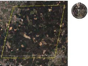
The task of Preparation for Data Acquisition, already completed, involved two activities. In the first place, the study area was selected in terms of surface area, vegetation characteristics, topography and geographic location. Secondly, key parameter values were identified for the acquisition of the laser and image data. The study area was selected nearby the city of Águeda, in the district of Aveiro, in the Northern part of Portugal. The selected area measures 3 x 3 km2 (Figure 1) and, while dominated by eucalypt plantations, also includes some pine stands and built-up areas. The latter are needed to verify the quality of the laser measurements. The forest stands in the area comprise regular as well as irregular plantation schemes, and stands with as well as without extensive undergrowth. The topography of the study area varies from gentle to steep slopes.
The relevant parameters concern the number of laser points per m2 as well as the number of spectral bands and pixel size of the images. In the course of the reporting period, the research team became acquainted with a recent laser system, the so-called full-wave system. For forest inventories, this new system is far superior to the traditional, pulsed system. This is due to the fact that not just the pulse time but the entire laser signal is recorded, providing valuable additional information. Therefore, it was decided to use the full-wave system. The point density was, in mean, 10 points per m2. The images are CIR, orthorectified with a pixel of 10 x 10 cm2, which is similar to the size of the laser footprint.
Figure 1 - Selected study area
As a result of this phase, the study area was selected and the acquisition of the laser data and images prepared. The flight took place on the 14th of July. The flight trajectory and the image expositions are shown in figure 2. The laser data and images, both orthorectified and stereo pairs were delivered in October of 2008. The laser data acquired per flying line is adjusted (corrected for errors) and stored in the form of blocks (Figure 2). A sample of the laser data and the corresponding digital orthophoto are shown in figure 3. In this figure the colours assigned to each laser point corresponds to its height. A sample of laser data within the study area is shown in figure 4 in 3-D.
Figure 2 - Flight Trajectory. The dots illustrate the image expositions and the lines the flight path. The rectangles represent the laser blocks
Figure 3 - A sample of the laser data and the corresponding digital orthophoto
Figure 4 - Laser data acquired on the study area
The phase for Acquisition and Processing of Validation Data is presented in detail in GOMES PEREIRA et al., 2009. The phases Development of the Proposed Procedure and Testing and
Evaluation of the Proposed Procedure are being implemented. The obtained results will be published in a later stage.
References
GOMES PEREIRA, L., GONÇALVES, G., SOARES, P., TOMÉ, M., 2009. Planning and Acquisition of control data to validate forest inventory and the estimation of fuel variables derived from LiDAR data and high resolution CIR images. 6º Congresso Nacional de Floresta. Ponta Delgada, Açores, pp. 10 (nas Actas deste Congresso).