American Journal of Engineering Research (AJER)
e-ISSN: 2320-0847 p-ISSN : 2320-0936
Volume-5, Issue-10, pp-102-110
www.ajer.org
Research Paper Open Access
Integrated Storm Water Management
–
An Approach for Urban
Flooding In Hyderabad, India
Zameer Ahmed
1, Prof.D. Ram Mohan Rao
2, Dr. K.Ram Mohan Reddy
3,
Dr. Y. Ellam Raj
41
Director (Tech), NCPE IIPL, Hyderabad, India 2
Prof., Dept of Civil Engg., MJCET, Hyderabad, India 3
Professor and Head, Water Resources Division, JNTU, Hyderabad, India 4
Dean, AVN institute of Engineering and Technology, Hyderabad, India
ABSTRACT: Flooding in general and urban flooding became common event in world and in India. Un-even
distribution of rain fall coupled with rapid and unplanned urbanization, encroaching upon and filling up natural drainage channels and urban lakes to use the high-value urban land for buildings are the cause of urban flooding. The illegal filling of urban water bodies in cities like Calcutta, Delhi, and Hyderabad etc. is a unchecked. Storm water management has become complex phenomenon especially in urban scenario where land costs are high. Especially in cities like Hyderabad, India, where unplanned settlements are more common in low laying areas which are water bodies once upon time. Integrated stormwater management is simply thinking about all of the factors that somehow affect precipitation as it moves from the land surface to an eventual receiving water. It is the process of accounting for all of these factors (e.g. rate, volume, quality, ground water impact) in a logical process so that inadvertent mistakes are not made that could eventually harm a resource. In Integrated Stormwater management by prioritizing goals and actions (ideally through consensus) provides a road map for moving towards a target condition by identifying the interconnected nature of goals, values and expectations, risks and opportunities, what needs to be done to manage the risks and achieve the opportunities, who should be responsible, a general timeline for implementation.Keywords: Urban Flooding, Integrated storm water management, Risk, vulnerability, Response, Recovery
I.
INTRODUCTION
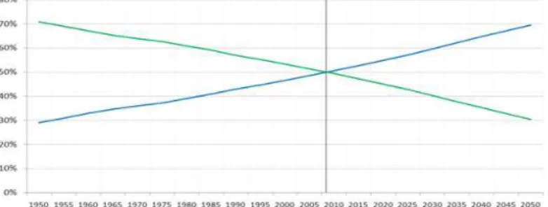
The United Nations projected that half of the world's population would live in urban areas at the end of 2008.[1] It is predicted that by 2050 about 64% of the developing world and 86% of the developed world will be urbanized.[2] That is equivalent to approximately 3 billion urbanites by 2050, much of which will occur in Africa and Asia.[3] Notably, the United Nations has also recently projected that nearly all global population growth from 2016 to 2030 will be absorbed by cities, about 1.1 billion new urbanites over the next 14 years.[4]. Fig 1 shows Global historical shift of the Urban/rural population ratio. With high densities of urban population and assets and more than 80% of cities are in river basins or closer to coast or both flooding possess a challenge.
Recent statistics clearly indicate that economic damages caused by urban floods are rising [5]. On one hand, the continuing urbanization process in combination with an over-proportional growth of values in cities is responsible for this trend, while on the other hand floods are indeed increasing, both in terms of frequency and magnitude. From the available records there has been a rise in floods since 1960 and since early 1990 this increase is more significant. Fig 2 shows the number of flood disasters since 1960 worldwide.
Figure 2: Number of Flood disasters
Although cities in areas experiencing heavy precipitation due to their very nature of having large impervious areas, so that the rain flood water and wastewater do not infiltrate into the ground, produce large run-off which the drainage network cannot accommodate, are potentially exposed to floods. Irrespective of whether urban floods are part of larger riverine floods or result from inadequate drainage capacities, the damage potential of floods in cities is extraordinarily high. Given the high spatial concentration of people and values in cities, even small scale floods may lead to considerable damages. In extreme cases urban floods can result in disasters that set back urban development by years or even decades.
Under these circumstances the sustainable management of urban flood risk is becoming an increasingly challenging task for urban communities and the responsible authorities to address. Too often urban flood management is marked by a narrow view on floods, concentrating on hydraulic and engineering aspects of flood management while ignoring spatial, ecological, political and socio-economic aspects and risks.
Flooding is often a major problem in cities in general and Hyderabad, India is not an exceptional case. Informal settlements are located along natural drains or in low laying areas are more prone to severe and frequent flooding
II.
LITERATURE REVIEW
1. Urban Flood Risk:
Primarily risk is understood superficially by equating it with the occurrence of an extreme event or hazard (flood, drought, earthquake, storm, landslide etc.) caused by natural forces or by a combination of natural forces and human influences. However it is necessary to consider the second component in the creation of risk is the fact that somebody or something has to be at risk; i.e. vulnerable to a hazard.
“Risk is the probability of a loss, and this depends on three elements: hazard, vulnerability, and exposure. If any
of these three elements in risk increases or decreases, then the risk increases or decreases respectively.”[6] Risk = function (Hazard x Exposure x Vulnerability)
2. Vulnerability Of Urban Areas To Floods:
Vulnerability is the most crucial component of risk in that it determines whether or not exposure to a hazard constitutes a risk that may actually result in a disaster. If the potential exposure to floods becomes reality, i.e. when flood waters physically encroach on people and infrastructure, then the vulnerability of people and infrastructure is decisive for the degree of harm and damage. Three types of vulnerability can be distinguished: Physical vulnerability of people and infrastructure;
Unfavorable organizational and economic conditions; and Attitudes and motivations.
Briefly, the vulnerability to flood risks in urban settlements, particularly in developing countries in informal developments can be attributed to the following factors:
Risk prone areas are the only areas that the poor migrants are able to afford Failure to perceive flood risks due to lack of knowledge till a flood strikes Infrastructure to reduce risk is not economically viable
3. Impacts Of Urban Floods
Urban floods have large impacts particularly in terms of economic losses both direct and indirect. Flood risks are a function of exposure of the people and the economic activities along with the vulnerability of social and economic fabric. As such the impact of such floods on the lives and livelihoods of people, a function of their vulnerability, needs to be understood. A number of urban characteristics particularly in low and middle income countries that have relevance to the increased flood risks are:
i. Concentrated population due to concentrated income earning opportunities; ii. Large impermeable surfaces and construction of buildings;
iii. Concentration of solid and liquid waste without any formal disposal systems; iv. Obstructed drainage systems;
v. Intensive economic activities;
vi. High value of infrastructure and properties;
vii. Forcing out of poor from official land markets giving rise to informal settlements; viii. Housing without any health and hygiene standards; and
ix. Changes in regions around cities.
4. Integrated Management Of Urban Floods
Final goal of any integrated urban flood risk management is to minimize human loss and economic damages, while making use of the natural resources for the benefit and well being of the people. However it is realized flood risks cannot be entirely avoided, thus they have to be managed. This may be achieved either by reducing flood risks to an acceptable level or by retaining, sharing or transferring flood risks through respective measures. This can be achieved by proper understanding of
i. risk assessment,
ii. planning and implementation of measures, iii. evaluation and risk reassessment.
5. Risk Assessment
Urban flood risk assessment starts with study of present and future flood risks with respect to hazard, exposure and vulnerability. Risk assessment has to be carried out in an integrated manner, by identifying all the possible water related hazards, including floods are likely to develop in the future as a result of urbanisation. Different cases should be studied in order to see the effects of likely future changes on urban floods (i.e. urbanization, reduction in green cover, reduction in infiltration capacity, climate variability and change, land use changes etc.). A risk mapping using GIS can be used for analysis purpose.
5.1 Planning And Implementation Of Measures
Planning and implementation includes Preparedness; Response; and Recovery. Preparedness measures attempt to prevent potential risks turning into disasters. Response measures are implemented during or directly after a flooding incidence. Preventive and preparatory measures are generally more cost-efficient and sustainable than emergency response measures. Recovery aim to the definitive reconstruction of damaged infrastructure.
5.2 Evaluation And Risk Assessment.
The evaluation of risk is concerned with issues relating to how those affected by risks perceive them, the value issues underlying the perceived problem and the trade-off between the perceived risks and benefits. Risk evaluation attempts to define what the estimated risk actually means to people concerned with or affected by the risk. A large part of this evaluation will be the consideration of how people perceive risks.
6. Approaches To Reducing Flood Risk
6.1 Structural Actions
• Restoration of natural features of catchment, including wetlands, forests and floodplains • Clearance and repair works to rivers
• Channel improvements, Walls, embankments and other defenses • Barriers, barrages and other dams or storage structures
6.2 Non Structural Actions • Zoning
• Building Codes
• Flood warning/Forecasting
• Public awareness raising campaigns • Planning system and planning decisions • Emergency response
• Relocation • Compensation • Temporary defenses
III.
STUDY AREA: HYDERABAD, INDIA
Hyderabad is the capital of southern India's Telangana state. It is fourth most populous city and sixth most populous urban agglomeration in India. It is second largest urban agglomeration in India. Average altitude is 542 meters. Hyderabad is situated on hilly terrain around artificial lakes. Greater Hyderabad Municipal Corporation is spread over an area of 650 Sq. Km and Hyderabad Metropolitan Development area is spread over 7100 Sq. Kms. Population of GHMC as per 2011 census is 68,09,970 and projected as 1,52,00,000 by 2046.
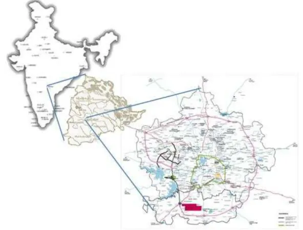
Figure 3: Study Area, Hyderabad, India
Heavy rain from the south-west summer monsoon falls between June and September, supplying Hyderabad with most of its mean annual rainfall. Since records began in November 1891, the heaviest rainfall recorded in a 24-hour period was 241.5 mm (10 in) on 24 August 2000. Many research papers said that in recent years number of rainy days are decreasing and this trend is going to be continued. For Hyderabad it has analysed that the reduction in number of rainy days from 1951 to 2007 is 10.7%(7). However at the same time as per Sri. Laxman Singh Rathore, Director General, Indian Meteorological Department, at the inauguration of an International Conference on Bio-resource and Stress Management (ICBSM) here on 18th Jan, 2015“Projections of monsoon rainfall pattern over Indian sub-continent indicate that by 2050, 10 per cent increase in the amount and intensity of rainfall is expected due to climate change, leading to increase in erosive power of rainfall. Even one per cent increase in rainfall intensity will increase rainfall erosive power by 2 per cent and soil loss from crop lands by 1.5 per cent,”(8)
Figure 4: Variation in Intensity of rain fall
The Analysis of rainfall data of Hyderabad IMD station from 2000 to 2010 revealed that there is a considerable increase in number of rainfall events of 20 mm/hr and 40 mm/Hr.(9) From the graph it is evident that rain fall intensities are increasing with time resulting in to more urban flooding.
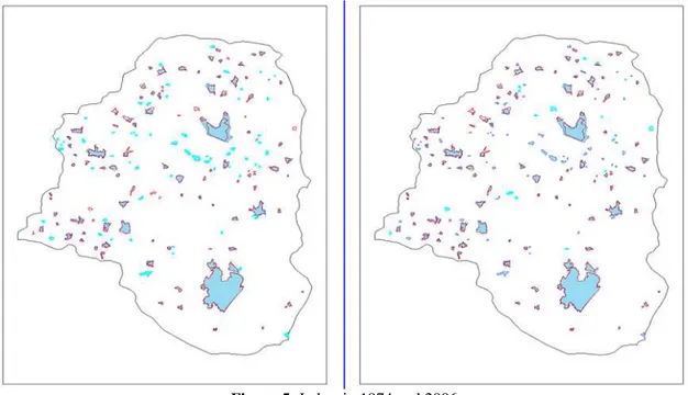
During 1906, Musi river floods the then Nizam created 534 artificial lakes in the chain form in the city to minimize the flood effect and make use of flooded water for future needs. After century t there are only 169 lakes left in the city. All the others have been encroached upon. The rapid urbanization and industrialization of Hyderabad resulted in drastic increase of the urban sprawl which in turn posed severe pressure on urban lakes by deteriorating water quality and ultimately finally resulting in the water body vanishing. Comparison of Survey of India toposheets of 1974 and 2005-06 showed that 156 tanks occupying an area of 13.86 Sq.km was reduced to 109 tanks occupying an area of 12.06 Sq Km. Total 64 Tanks were disappeared and 17 new tanks were formed in the area
Figure 5: Lakes in 1974 and 2006
Water logging was also reported in areas such as Mehdipatnam, Uppal ,Ramanthapur,Dilshuknagar, Kapra, GaddiannaramVijaynagar Colony, Tolichowki and M.J. Market, Malakpet, Secundrabad , Banjara hills ,Ameerpet, Kukatpally, NMDC, L.B.Nagar, Amberpet ,6.no, Nallakunta , Lakdikapul, Chaderghat , S.R.Nagar, Moosapet, Tukaram gate Junction, Near Mahendra hills T Junction, Near magna super market, Habsiguda cross road. Near Vittalwadi X roads, Near Tourist hoteletc
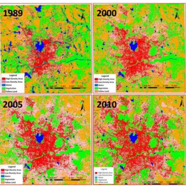
Figure 6: Urbanisation in Hyderabad
Fig 7 shows the land use changesdue to urbanization in Hyderabad with time. From the figure it can be concluded that area under water bodies has decreased from 10000 acres to 3800 acres, High density urban area has increased from 22000 acres to 61000 acres, whereas follow land has decreased from 70000 acres to 40500 acres in a span of 21 years.
The drainage system in Hyderabad comprises of a hierarchy of natural and man-made drains and water bodies that ultimately discharge surface run-off into River Musi and Hussain Sagar. Numerous lakes and nalahs constitute a major storm water drainage system for the area .The nalahs are the major carriers of storm water finally disposing into the river and water bodies in the catchment.
IV.
INTEGRATED STORMWATER MANAGEMENT PLANNING AND DESIGN
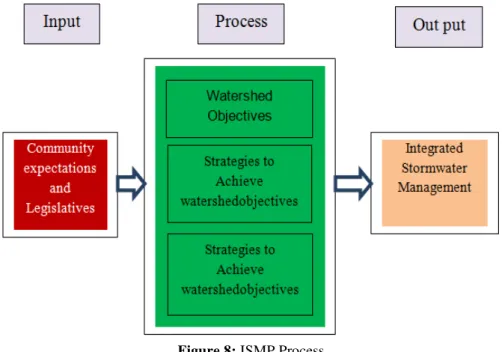
The objectives of an Integrated Stormwater Management plan (ISMP) will be watershed-specific, with following components:
Drainage Objectives - Alleviate existing and/or potential drainage, erosion, and flooding concerns. Stream Protection Objectives - Protect and/or restore stream health, including riparian and aquatic habitat. Water Quality Objectives - Remediate existing and/or potential water quality problems.
The ISMP should focus on the integration of stormwater management and land use planning. An ISMP is an integral component of a local government‟s land development and growth management strategy because upstream activities (land use change) have downstream consequences (flood risk and environmental risk). A Layered approach may be useful to develop ISMP. Layered approach may involve
First Layer – Identify the stormwater-related objectives for a watershed (e.g. protection of aquatic resources, protection of life and property, protection of water quality). These objectives define what the ISMP is striving to achieve.
Second Layer – Develop strategies to achieve the watershed objectives. This includes setting performance targets to guide selection of site design solutions.
Third Layer – Implement appropriate site design solutions (e.g. source controls) for achieving performance targets that suit local objectives and conditions.
To select appropriate storm water management strategies and site design solutions, it is first necessary to identify the resources to be protected, the threats to those resources, and the alternative management strategies for resource protection.
Figure 8: ISMP Process
From Output derive ISMB deliverables and Scope of deliverables
S. No ISMP DELIVERABLE SCOPE OF DELIVERABLE
1 An inventory of the physical and biological systems
streams, rivers, and drainage systems, wetlands, ponds and lakes, infiltration areas and aquifers, land use information flooding and erosion problem areas, water quality problems
2 Component plans to protect key resources, resolve identified problems, and accommodate development
plan for integrating appropriate source controls with land development, including a description of any required regulatory changes, plan for improvements to drainage systems and stream reaches, plan for ongoing data collection and monitoring, cost estimates for all planned actions
3 An implementation program Administration, projects, phasing and budgets, financing mechanisms, community education, maintenance activities, standards and schedules, performance monitoring
After defining the deliverables, seven step process may be used for development and implementing ISMP.
Step Scope Description
1 Secure Political Interest and Support
Inter-departmental & inter-agency steering committee
Political and public support
Stakeholder focus groups
An ISMP process starts with a high-level political commitment to protecting property, water quality and aquatic habitat. This is required to convert high-level policy statements into concrete action so that there will be a flow of funding for the ISMP process. Without political support for funding, there will be no ISMP process. Once funding is assured, however, a key to a successful outcome is that there be a commitment by all stakeholders to make the ISMP process work.
2 Frame the Watershed Problems and Opportunities
Assemble existing information
Identify and prioritize problems (knowledge-based approach)
This involves application of an interdisciplinary roundtable process. To identify and rank the problems and opportunities in a watershed. Sufficient time must be invested at this stage to ensure that there is a clear understanding of the problems to be solved. This understanding will then guide the rest of the ISMP process. 3 Develop Objectives and Alternative Scenarios
Establish desired levels of environmental protection and other objectives
Set appropriate performance targets
Model alternative scenarios for achieving targets
It involves further application of the interdisciplinary roundtable process to:
i. determine which problems and/or opportunities are priorities for action
ii. establish objectives for dealing with these priority problems/opportunities
iii. develop alternative scenarios for achieving the objectives Developing a common understanding among participants in the ISMP process is key to developing a shared vision of what is desirable, practical and achievable.
4 Collect Meaningful Data and Refine Scenarios Collect data needed to:
refine scenario models
evaluate effectiveness and affordabilitye.g. hydrometric data, soils data
Collect the additional data that may be needed to evaluate the effectiveness, feasibility and affordability of implementing the scenarios identified in Step #3 for meeting watershed objectives. This step may involve collecting site-specific data to refine the assumptions of the scenario models generated in Step #3
5 Evaluate Alternatives & Develop ISMP Component Plans
Land Development Action Plan
Habitat Enhancement Plan
Flood Risk Mitigation Plan
Once watershed objectives have been established, alternative scenarios for achieving those objectives have been generated, and the data needed to evaluate the effectiveness of these scenarios has been collected, the next step is to evaluate the alternatives and make decisions.
These decisions will provide the basis for developing plans for habitat enhancement, flood risk mitigation and relevant land development actions. These are all related components of an ISMP..
The fourth component is a financial and implementation program (see Step #6), which is essential for moving from planning to action.
6 Develop an Implementation Program Finance and implement ISMP actions
The Financial Plan and Implementation Program should therefore outline how the land acquisition and capital financing of the elements can be achieved. Tools might include negotiations during zoning changes, land exchange, density bonuses. Strategies will be specific to the properties in question.
In addition to capital financing, the regulatory framework is another component of implementation to be used in balance with public awareness and capital works programs.
7 Refine Through Adaptive Management Define adaptive management rules, roles and responsibilities
Constantly improve integrated solutions
V.
CONCLUSION
Storm water management is a complex phenomenon especially in urban scenario where land costs are high. Especially in cities like Hyderabad, India unplanned settlements are more common in low laying areas which are water bodies once upon time. Since flooding is not a frequent process, people are ready to live in this areas as the chances of flooding is once in five or ten years. This is resulting into further worsening of the problem and frequency flooding is increasing. This is multiplying with changes in climate due to which intensity of rain is increasing year by year. A long-term vision is necessary to focus on urban stormwater management.
This vision provides a context for all planning, data collection, sensitivity analyses, capital expenditures and regulatory changes. In Integrated Stormwater management by prioritizing goals and actions (ideally through consensus) provides a road map for moving towards a target condition by identifying the interconnected nature of goals, values and expectations, risks and opportunities, what needs to be done to manage the risks and achieve the opportunities, who should be responsible, a general timeline for implementation. This framework addresses the goal of identifying options to change the way that land is developed and re-developed, so that people, property and natural systems can be better protected and over time, infrastructure can be managed more efficiently and watersheds can become healthier.
REFERENCES
[1]. "UN says half the world's population will live in urban areas by end of 2008". International Herald Tribune. Associated Press. 26 February 2008. Archived from the original on 9 February 2009.
[2]. "Urban life: Open-air computers". The Economist. 27 October 2012. Retrieved 20 March2013. [3]. "Urbanization". UNFPA - United Nations Population Fund.
[4]. Barney Cohen (2015). "Urbanization, City Growth, and the New United Nations Development Agenda". 3 (2). Cornerstone, The
Official Journal of the World Coal Industry. pp. 4–7.
[5]. MunichRe, 2005. Megacities – Megarisks: Trends and Challenges for Insurances and Risk Management, http://www.munichre.com/publications/302-04271_en.pdf
[6]. Crichton, D., 1999. The Risk Triangle. In: Ingleton, J. [Ed.]. Natural Disaster Management. Tudor Rose. 102-103.
[7]. Khailesh Kumar Kharol, D. G. Kaskaoutis, Anu Rani Sharma, and Ramesh P. Singh: Long-Term (1951–2007) Rainfall Trends around Six Indian Cities: Current State, Meteorological, and Urban, Advances in Meteorology, Volume 2013 (2013), Article ID 572954, 15 pages, http://dx.doi.org/10.1155/2013/572954
[8]. Newspaper article: The New Indian express, Published: 09th January 2015.