The elaboration of the urban and environmental development master plan of
Candiota/RS in the perpective of the built heritage
A elaboração do plano mestre de desenvolvimento urbano e ambiental de
Candiota / RS na perpectiva do património construído
DOI:10.34117/bjdv6n2-050
Recebimento dos originais: 30/12/2019 Aceitação para publicação: 05/02/2020
Renan Rosso Bicca
Arquiteto e Urbanista, mestrando (PROGRAU)- Universidade Federal de Pelotas (UFPEL) renan-rosso@hotmail.com
Jose Leonardo De Souza Castilho
Arquiteto e Urbanista, M.Sc. Geomática (UFSM)- Centro Universitário da Região da Campanha (URCAMP)
leonardocastilho@urcamp.edu.br
Maria De Fátima Schmidt Barbosa
Arquiteta e Urbanista, Esp. Artes visuais (URCAMP)- Centro Universitário da Região da Campanha (URCAMP)
mariabarbosa@urcamp.edu.br
Maria Elaine Dos Santos Leon
Informata, M.Sc Geomática (UFSM)- Centro Universitário da Região da Campanha (URCAMP) meleon79@gmail.com
Magali Nocchi Collares Gonçalves
Arquiteta e Urbanista, Dra. Arquitetura (UFRGS) -Centro Universitário da Região da Campanha (URCAMP)
magalicollares@yahoo.com.br
Mariana Hoesel Scherer
Arquiteta e Urbanista, Esp. Docência do Esino Superior (URCAMP)-Centro Universitário da Região da Campanha (URCAMP)
maryhscherer@yahoo.com.br
Marília Pereira De Ardovino Barbosa
Arquiteta e Urbanista, M.Sc. Arquitetura (UFGRS) - Centro Universitário da Região da Campanha (URCAMP)
mariliabarbosa@urcamp.edu.br
ABSTRACT
The Centro Universtário da Região da Campanha - URCAMP, through an agreement signed between the City Hall of Candiota/RS, together with the technical and financial support from the Pampa Sul Thermoelectric Power Plant (Miroel Wolowski), constituted a study group, called NEDUA ( Center for Urban and Environmental Development Studies) formed by professionals and academics from different areas of knowledge, which had the objective of elaborating the proposal of the Candiota Master Plan. The municipality is located in the southern region, close to the Uruguayan border and it
is known for its reserve and extraction of coal, as well as for the generation of electricity. The Master Plan is regulated by the Federal Law 10.257/2001 - Cities Statute, which sets out basic and complementary instruments for the urban planning and development, as well as guaranteeing social policies for the population, especially the most needy. The project lasted for two consecutive years through surveys, field research, historical references and technical readings, community readings, among others. The Plan itself should be a living and dynamic law that integrates necessary transformations to the principles of sustainable and socially fair development, guiding the structural investments to be made by the public and private entities. In order to carry out that process, the teams were divided into five subjects: Heritage, History and Culture; Urban, Infrastructure, Services, Land Use and Occupation; Environmental and Rural; Economic, Social and Security Development; Legal, Planning and Management. This article will discuss the Heritage, History and Culture where it was revealed demands and enthusiasm in the preservation of its memory.
Keywords: Built Heritage, Master Plan, Candiota.
RESUMO
O Centro Universitário da Região da Campanha - URCAMP, por meio de convênio firmado entre a Prefeitura de Candiota / RS, juntamente com o apoio técnico e financeiro da Usina Termelétrica Pampa Sul (Miroel Wolowski), constituiu um grupo de estudos, denominado NEDUA ( Centro de Estudos de Desenvolvimento Urbano e Ambiental), formado por profissionais e acadêmicos de diferentes áreas do conhecimento, que tiveram como objetivo elaborar a proposta do Plano Diretor de Candiota. O município está localizado na região sul, perto da fronteira com o Uruguai e é conhecido por sua reserva e extração de carvão, bem como pela geração de eletricidade. O Plano Diretor é regulamentado pela Lei Federal 10.257 / 2001 - Estatuto das Cidades, que estabelece instrumentos básicos e complementares para o planejamento e desenvolvimento urbano, além de garantir políticas sociais para a população, principalmente as mais carentes. O projeto durou dois anos consecutivos através de pesquisas, pesquisas de campo, referências históricas e leituras técnicas, leituras da comunidade, entre outros. O próprio Plano deve ser uma lei viva e dinâmica que integre as transformações necessárias aos princípios de desenvolvimento sustentável e socialmente justo, orientando os investimentos estruturais a serem feitos pelas entidades públicas e privadas. Para realizar esse processo, as equipes foram divididas em cinco temas: Patrimônio, História e Cultura; Urbano, Infraestrutura, Serviços, Uso e Ocupação do Solo; Ambiental e Rural; Desenvolvimento Econômico, Social e de Segurança; Jurídico, Planejamento e Gestão. Este artigo discutirá o Patrimônio, a História e a Cultura, onde foram revelados demandas e entusiasmo na preservação de sua memória.
Palavras-chave: Patrimônio Construído, Plano Diretor, Candiota.
1 INTRODUCTION
The Centro Universitário da Regiao da Campanha, URCAMP, in agreement with the Candiota City Hall and technical and financial support from UTE Pampa Sul, formed a study group comprised of professionals and students from different areas of knowledge, aiming to elaborate the Participatory Master Plan of Urban and Environmental Development in Candiota. According to the Federal Constitution, Art. 182 and 183 and regulated by the Federal Law 10.257/2001, the City Statute is the basic instrument of the urban development and expansion policy, which is an integral part of a municipal planning process that aims to promote the full fulfillment of the social role of the city and property.
The city of Candiota, located in the southern region of Rio Grande do Sul state, jointly with URCAMP and the local community, university, aims at preparing the Master Plan for Urban and Environmental Development (PDDUA). The elaboration project began in May of 2016 and ended in November of 2017. The city of Candiota, which has large coal reserves, has companies, such as the Pampa Sul Thermoelectric Power Plant, for its development, and should, therefore, include in its Master Plan, in addition to appropriate normative provisions and instruments of urban policy, a system that establishes a structure of articulation between planning governmental and participatory instances.
It is important to note that the City Statute does not oblige all cities to prepare their Master Plans, but, cities within the area of influence of projects or activities with significant environmental impact at regional or national level, are required (E. C. Art. 41, V).
2 METHODOLOGY
The project proposes the reciprocal collaboration between the city of Candiota and the URCAMP University, to carry out studies and researches, seminars and publications related to the development of the city.
The promotion of the Master Plan elaboration process took place through participatory events between the community, the public power and the private interest, in which it was possible to discuss perceptions brought by the population for the future of the city. For this process the teams were divided according to the following topics: Heritage, History and Culture; Urban, Infrastructure, Services, Land Use and Occupation; Environmental and Rural; Economic, Social and Security Development; Legal, Planning and Management, each topic was responsible for presenting the existing conflicts and seeking solutions to those demands jointly with the community. The project had a multidisciplinary team, according to table 1, formed by teachers, students and graduates of the institution.
Table. 01: PDDUA Technical Team - Candiota/RS Source: NEDUA 2017
The elaboration of the plan was carried out in stages, including the reading of the local reality, which contributed to the elaboration of texts, tables, maps and graphical elements containing the survey of data and information related to the current conditions of the natural environment and the built environment, the urban growth and expansion trends, the characterization of the population and the socioeconomic system, the regional relations and the analysis of the adequacy of the current legislation. The community reading basically consists of interviews, workshops, lectures and other forms of recording the city's image and the seizure of the territory by the population in its different socioeconomic and cultural backgrounds. Holding of public hearing.
Reports composed of texts, tables, maps and basic elements containing the proposal of general guidelines, strategies and priority topics of the master plan. Definition of the fields of action, strategic axes and urban model. Holding of public hearing.
And finally, the drafting of the Master Plan minutes, composed of the speeches of the plan (objectives, strategies), the norms of use, occupation and parceling of land, the forms and places of application of the instruments provided for in the City Statute, of the definition of the planning municipal system.
3 RESULTS and DISCUSSION
The Candiota region1 is located southwest of the Rio Grande do Sul state, approximately 402 km from Porto Alegre, by the BR 293 and BR 153 roads, (Figure 1).
Fig. 01: Entrance way to Candiota/RS Source: Candiota.rs.gov.br (2016)
According to Dal Molin (1994) the occupation of the current city of Candiota, from 1800 one, comes from the ranches, consequently the livestock activity. As an example, Dario Lassance comes from the rural estate of Tomé do Monte, succeeded by Flaubiana Gimenes, as well as the parcelling of the João Luiz d'Abreu Ranch (1994:20), giving rise to the "Village" of Santa Rosa, present-day renamed as Seival District. (fig.02).
Fig. 02: Santa Rosa Village – Seival Source: NEDUA (2016)
1According to oral researchers, some Greeks from Cândia island (now Crete), known as Candiotos, came from Argentina in the 18th
century, settling on the banks of a stream, which they would later name Candiota, hence the origin of the city name Source: https://en.wikipedia.org/wiki/Candiota
In these lands the Republic was proclaimed on September 11, 1836 in the "Battle of Seival", including having an alluding monument on the BR-293 road. (fig. 03) That battle, where the "farroupilhas" were victorious, it precedes the institution of the "Republic of Rio Grande", in September of the same year, being chosen the city of Piratini, as capital because it is a strategic place in the region (URBIM, 2001). In 1844, another battle on the "Cerro da Palma", near the Negro River, in the region of Candiota, which signals the involvement of the region with the farroupilhas battles, constituting as part of the history of the State.
Fig. 03: Stone Memorial of the Seival Battle – BR 153 Source: NEDUA (2016)
According to Fortunato Pimentel, the Mineral Production Board of the Secretariat of Agriculture began in 1840 the drilling works in the Candiota coal basin, with two objectives: to demonstrate the possibility of industrial exploration of coal and provide elements and indications for the elaboration of the future exploration plan. Thus, in August of 1867, the Decree no. 3924 of the Imperial Government grants to Cunha Plant and Cia. the right to build a railway from the city of Rio Grande to the coal center of Candiota, between the Jaguarão and Camaquã rivers (DALMOLIN: 1994,44). In parallel, from 1858 on, the Brazilian naturalized French, Guilherme Bouliech, conducts a specific study mission on the exploration of mineral coal in the region. However, according to Famurs (2012), as early as 1828 mineral coal settlements were known on the banks of the Candiota stream, as a result from the Mallet's wanderings with his soldiers.
Fig. 04: Candiota Stream – Cement Factory. Source: NEDUA(2016).
Until the end of the nineteenth century, the extraction was done by several coal companies. The mineral was rudimentarily extracted using shovels and taken to nearby mills.
According to the Collection of Laws of the Empire of Brazil (1878) on October 18, 1878, through the Imperial Decree No. 7.047, it granted permission to James Gracie Taylor and Miguel Gonçalves da Cunha to mine coal in the territory among the Candiotinha, Candiota and Jaguarão Chico rivers of the Province of São Pedro.
In 1884, a remarkable fact for the development of the village is the beginning of the construction of the railroad, called Cacequi-Maritime Line, by the "Southern Brazilian Rio Grande do Sul Railway Company Limited", successor to a series of previous concessions. The first construction was from Cacequi to São Gabriel in mid-1896 and from São Sebastião to Bagé, in the end of the same year, both by E. F. Porto Alegre/ Uruguaiana.
In 1900, the São Sebastião-São Gabriel connection would complete the Bagé-Rio Grande stretch. The passenger trains departed from Livramento, on another line, and arrived to Cacequi and from there to Bagé. From Bagé, through transfer, we reached Rio Grande. (GIESBRECHT, 2009). They transported cattle and beef jerky to the port of Rio Grande.
Fig. 05: Old Railway Station of Dario Lassance – Dario Lassance. Source: NEDUA (2016)
Due to the railway, it was buit several railway stations. In Candiota, four stations, according to Giesbrech (2009): Seival, Dario Lassance, Candiota and Bomba Candiota2.
The "Santa Rosa Station" causes the formation of the village. It allows the flow of the agricultural products production and others. The trade develops from the transportation of goods facilitated by the railway.
Fig. 06: Santa Rosa Station – Seival
Source: NEDUA (2016).
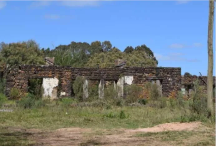
In the same period, end of XIX century, as a result of the implementation of the railway, the "Charqueada Santa Rosa/Drying Meat Factory of Santa Rosa" was inaugurated, first in the place, leveraging the "village" of the same name, as one of the largest exporters of beef jerky, leather and wool from the region, with raw materials suppliedt by farms on large land areas of the region.
Fig. 07: Drying Meat Factory of Santa Rosa Chimney Furnace– Seival Source: NEDUA (2016).
2.1 2 Station built in 1941, and for being located on the banks of the Candiota Creek, a pump was installed in it that made the water supply of the locomotives. Currently it is demolished. (GIESBRECHT, 2009).
But with the introduction of meat cooling systems, the drying meat factories have been extinct. Also, in 1926 it occurred an explosion in the boiler of the drying meat factory, in addition to the decay of the Banco Pelotense, which was headquartered in Pelotas with a branch in "Santa Rosa" and served cattle ranchers and drying meat workers at the beginning of the century.
Fig. 08: Old Marimon Winery – Seival
Source: NEDUA (2016).
On the other hand, based on the well-known vocation for grape cultivation in the region, the "Marimon Winery" is located in 1888, located in Seival Farm, owned by J.Marimon & Filhos, which is kept working over 70 years. The climate of Seival, the landscape, the fields and some other special characteristics contribute to the decision by João Marimon, on his arrival in Latin America, to found in 1888 the "Marimon Winery" (fig.08), with vineyards planted in the spaller form, vertically supported on the ground and not crowded, as verified in the Serra Gaúcha, in the horizontal position.
Fig. 09: Santa Rosa Church – Seival Source: NEDUA (2016).
Since the early twentieth century, the village of Seival has developed in all aspects, such as education, culture, religion and leisure. (Fig. 09). It founded in 1921 the "Grêmio Esportivo Santa Rosa”, with headquarter that promotes the coexistence in social and recreational level of the
inhabitants. The artist Cadmo Ardissoni, reference local artist, stands out at that time, with its educational, art, magic and drawings activities that depicted the locality.
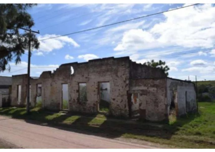
Fig. 10: Ruins of the Old Santa Rosa Club – Seival. Source: NEDUA (2016).
Seival becomes district by the state decree No. 7842, dated Jun/30/1939, with land split from the Aceguá district and annexed to the City of Bagé. It is known that in the 1940s, Harold Olmos, from the University of Davis , points out the Rio Grande do Sul’s Southern Region as one of the most propitious, in Brazil, for the cultivation of European noble viniferas, and that in the 70s, more detailed studies are carried out, proving the appropriate factors for viticulture. At the time, companies interested in the implementation of culture in the region were assisted, when there was no, interest, as well as encouragement from government sectors.
The locality originally called Seival3 and later called "Santa Rosa Village" goes back to its original name in 1936, due to the related coincidence with the Santa Rosa City, which generated institutional problems. After the First World War in 1917, the first mining company is set up in Candiota, when in Dario Lassance, an English technician named Appleby, arrives to explore a coal mine near the site of the present ruins of the old "stone house”4. (fig.11).
3According to some sources the name corresponds to the vegetation called by the Spanish as seibo, which
a large quantity is in seibal, which in turn translates to Portuguese language as Seival.
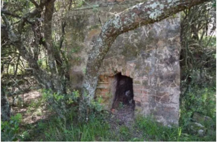
Fig. 11: Ruins of the Appleby Drying Meat Factory – Dario Lassance. Source: NEDUA (2016).
He implements the “Appleby’s Drying Meat Factory” which establishes a railway detour to the mines (which tunnels still exist), called Appleby. The village that develops around the station known as “Appleby Village” is called in 1930 Dario Lassance named after the railway engineer a month after his death. In 1935, the "Dario Lassance Station" was established, the building of which remains, to date, but with disfigurements.
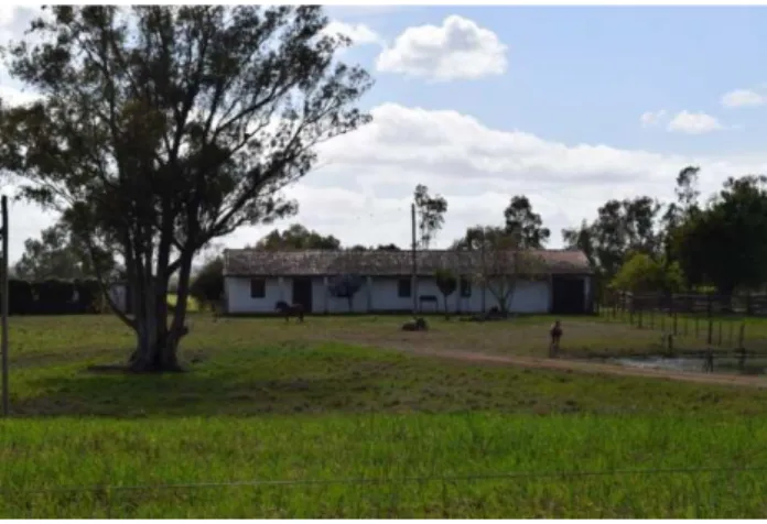
The Decree No. 24,693 of March 28, 1948, the DACM, authorizes the research and the following year the Candiota I Mine, as well as the Candiota I Thermoelectric Power Plant was designed. With the ending of the mining work in Hulha Negra in 1952 the DACM only work at the "Leão Mine", in Candiota. In order to supply the plant, it intensifies the production, and in 1969 became the CRM-Rio-Grandense Mining Company. Dario Lassance district arises from CRM's need to house its employees.
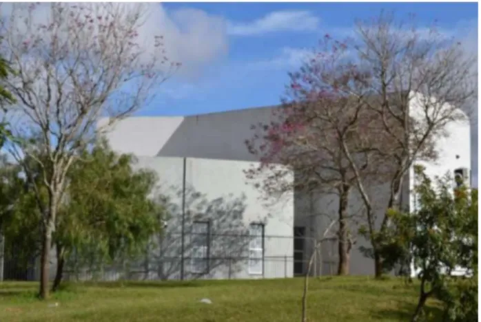
Fig. 12: Candiota I, Candiotão Cultural Complex – Residential Center. Source: NEDUA (2016).
In 1968, with the construction of a new railway among Hulha Negra, Pedras Altas and Herval, it excludes the passage through Seival. According to Cassio Gomes Lopes5, the construction of the RS 293 in the 70's is a 4.4km detour to the north, disabling the RS 84 for traffic from Uruguaiana to Pelotas, which harms the trade of the locality, bringing the inevitable decline and the subsequent migration of residents to other cities and districts for better living conditions.
Thus, at this time the locality begins to decline in all aspects, as it is no longer among the roads that interconnected the region. It is known that the community of Seival, unhappy with the stagnation situation and aware of the local potential for development joins Tupy Silveira and Hulha Negra for joint emancipation, which does not evolve6. Another fact that contributes to the emptying of Seival is the construction of the Candiota I Plant or “phase A”, and support center called “Vila Residencial”7,
after the Candiota II Plant or “phase B”, when the “Vila Operária” appears, as well as a boost in the occupation of the João Emílio and Dario Lassance Villages.
Fig. 13: Vila Residencial Square – Residencial Center. Source: NEDUA (2016).
As late as the 1940s, the National Department of Railways (DNEF) of the Ministry of Road and Public Works planned to electrify several rail sections in the State, including the connection between Rio Grande-Pelotas-Bagé-Torquato Severo (Dom Pedrito) stations. To achieve this goal, a 10,000-watt coal-fired power plant would be built from Candiota Mine.
5 In MOMO (2015)
6 In a process led by Gregório Ferreira, for the joint emancipation of Seival, Tupy Silveira and Hulha Negra, between 1964 and 1965,
which after positive findings towards the formation of the Municipality is definitively rejected by the State Legislative Assembly.
7 With housing models, the size and models of which are currently titled, mostly, sold to individuals with or without connection to
Fig. 14: Plenary of the Councilmen Chamberda – Vila Operária. Source: NEDUA (2016).
Thus, as early as the 1950s, studies began for the installation of a thermoelectric power plant in order to take advantage of the abundant raw material from the coal site. The idea of building a thermoelectric power plant in Candiota originates in the context of the second postwar period, when Brazil suffers a severe oil rationing, when the National Department of Railways (DNEF) of the Ministry of Road and Public Works plans to electrify several rail sections in the State, including the connection between Rio Grande-Pelotas-Bagé-Torquato Severo (Dom Pedrito) stations.
The Candiota I plant (fig. 04 and 05) belonging to the current CEEE, designed under the government of Eurico Gaspar Dutra, has started work in 1953 through a consortium made by the companies Alston, Stein, Roubax, from France, with interruptions that result in inauguration only in December of 1961, by the then President of the Republic, João Goulart. With the decommissioning of the "Old Plant"8, in 1973, in 1974 - CEEE's Candiota II President Médici Thermoelectric Power
Plant was inaugurated with phases A and B. 1986.
8
In 2014 the Candiota I Cultural Center was inaugurated, the only initiative of the municipality to restore its historic heritage, a CGTE initiative in agreement with the Candiota City Hall, as a result of PAC.
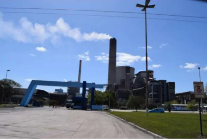
Fig. 15: UTE Presidente Médici, Phase A, B and C. – Residencial Center.
Source: NEDUA (2016).
In 1988, in the “impetus to revert the Seival's situation”, and to include the locality in the developmental “Candiota” outbreak, there was a movement in favor of paving the stretch between Seival and BR 293, passing through “Seivalzinho”, a project with topographic survey carried out and contacts with the DAER, which is ongoing for some years, and which is not effective.
The Candiota community, organized by a pro-emancipation commission, made up mainly of workers residing in the residential districts "Vila Operária" and "Vila Residencial", linked directly to CEEE and CRM employees and others, who went daily to Bagé , promote movement for the emancipation, from 1990, which becomes effective on March 24, 1992.
Still in 1975, studies are made to implement the Thermoelectric Plant Candiota III, based on a bi-national agreement with Citic Group, maintained by Eletrobrás/Thermal Power Generation Company (CGTEE). Most recently built and completed in 2011, which currently configures the operation of the three phases A and B (fig. 10) and C.
Currently, the locality of Seival regains strong momentum, due to the own characteristics of the soil, linked mainly to the existence of mineral coal, such as the establishment of companies in the wine and seeds sector. Companies such as Miolo, SSM Mineradora, Isla Sementes and mainly Engie's Pampa Sul Thermoelectric Power Plant - implemented in 2015, with an investment that should represent a new development cycle for the Seival region.
It is concluded that the current municipality develops from the historical trajectory of the formation of the localities of Seival and Candiota. It is defined as involving events that trigger occupations, evictions, exchanges, commercial and industrial relations, between golden and decaying periods.
Set up since 1992 as members of the City of Candiota, they are currently two industrial foci, linked to the extraction of coal and energy production, close to the current "Seival District" and the current headquarter of the Municipality. The others commercial and industrial activities linked to
agricultural and pastoral production, fruit production and especially to viticulture, "spread" indistinctly throughout the municipality.
Around the development and creation of industrial and commercial activities of the municipality, it is possible to see a significant disconnection with Bagé - "mother municipality" and expand residential and service districts such as Dario Lassance, João Emílio, Residential Village, Vila Operária and Seival, among others, which establish the poly-nuclear characteristic of the locality. Candiota is the National Coal Capital and there are many perspectives on projects that use the "black gold".
Cultural heritage is made up of monuments, sets of buildings and archaeological sites of fundamental importance for the memory, identity and creativity of peoples and the richness of cultures.
Art.216. The cultural heritage of the country is the material and immaterial goods, taken individually or together, bearers of reference to the identity, action, memory of the different groups that form the Brazilian society.
(Federal Constitution of 1988, Decree-Law No. 25 dated November 30, 1937).
The material heritage protected by Iphan is composed of a set of cultural goods classified according to their nature, according to the four Books of the Listing: archaeological, landscape and ethnographic; historic; fine arts; and the applied arts. The Federal Constitution of 1988, in its Articles 215 and 216, broadened the notion of cultural heritage by recognizing the existence of cultural goods of a material and immaterial nature, and also by establishing other forms of preservation - such as the Registry and Inventory – besides the Listed Bulding, instituted by the Decree-Law no. 25, of November 30, 1937, which is mainly suitable for the protection of buildings, landscapes and urban historical complexes.
The listed assets of a material nature may be immovable such as historical cities, archaeological and landscape sites and individual goods; or movable, such as archaeological collections, museum, documentary, bibliographic, archival, videographic, photographic and cinematographic collections.
The Listed Urban Complexes list (Depam/Iphan - December of 2015) describes assets that are part of the material heritage. In the following pages, the cities with their ensembles, centers, centers and historical sites are grouped by region of the country, with information on the historical contexts in which they arose and developed, as well as the description of the monuments and public spaces listed in each locality.
The urban ensembles listed in the cities of the Southern Region have an architectural and artistic heritage where features inherited from the historical richness and cultural diversity of its founders and inhabitants are preserved, as well as numerous archaeological sites. In the states of Parana, Santa Catarina and Rio Grande do Sul, settlements sprang up around Brazil's first gold mines, immigrant settlements, and from fortifications erected by Portugal - on the coast and at the borders - to avoid the presence of Spanish and French who tried to settle in these territories.
In Rio Grande do Sul, the cities of Porto Alegre, General Câmara, Jaguarão and Santa Tereza gather cultural assets representative of the legendary battles where the borders were disputed between the kingdoms of Portugal and Spain, and the Farroupilha Revolution, from 1835 to 1845, when the farroupilhas fought against the Imperial Government of Brazil. The remaining heritage of the Azorean colonization, the Italian colonial regions with the characteristics of Italian-Brazilian architecture, and the large Portuguese colonial mansions stand out in the urban areas listed in this State.
The memory of the city was built through data collected from research in books published on the "Candiota History", as well as sources from magazines, newspapers, course completion paper and interviews. The dates follow the historical chronology drawn according to investigations of texts, photos and material to accurately constitute the timeline at that location (Figure 16).
Figure 16. Candiota Timeline Source: NEDUA (2016)
“Part of the natural heritage is also threatened as the historical, artistic and cultural heritage ”. It is part of the identity of a place as the basis for building a livable city. It is not a matter of destroying and creating new hypothetically greener cities, where it is not always desirable to live. It is necessary to integrate the history, culture and architecture of a place, safeguarding its original identity. For this reason, ecology also involves the care of the cultural wealth of humanity in its broadest sense.”
(Papa Francisco – Encyclical Letter Laudato Si’ on the care with the common home, 2015, page. 118)
Figure 17. Urban Centers Map of the City, images from Google
Source: NEDUA (2017)
The landscape of the municipality of Candiota stands out for the set of urban centers firstly formed by Seival, followed by Dario Lassance District, Vila Residencial, Vila Operária, João Emílio District and lastly São Simão District. The images researched throughout the survey are according to photo caption and numbered per degree of importance and historical value that will be fundamental to the memory of the city.
4 FINAL CONSIDERATIONS
Even with characteristics of polynuclear urban occupation, the material assets that shape the urban image of the City as a whole are sparsely identified. These contribute to raising awareness of the Candiota’s citizen about the importance of preserving that heritage, whether of historical, cultural and/or architectural relevance, constituted over the years.
Thus, it is concluded that the Candiota Urban and Environmental Development Master Plan is based, for its elaboration, on the inclusion of strategies of heritage appreciation, considering the historical and political importance of the area at the regional level. From the research, monuments to be preserved through listed buildings and which should be included in defined zones of architectural, historical, cultural and environmental preservation can be found.
REFERENCES
BRANCO, Suelen Cantelli; DA SILVA, Gabriel Borges. Report on the Historical and Cultural
Heritage of Candiota Municipality) – RS. Chapecó -SC. 2009.
BRASIL. Law no. 10.257, dated July 10, 2001. It provides the articles 182 and 183 of the Federal Constitution that establishes general guidelines of the urban policy and gives other provisions.
Brasília: Presidency of the Republic [2001]. Available on:
http://www.planalto.gov.br/ccivil_03/leis/leis_2001/l10257.htm. Access on: Aug/05/19
BRASIL. Decree-Law no. 3.924, dated August 3, 1867. It approves the requirements to build a railway by the more economic way or a tram-road, departing from a City in Rio Grande do Sul to
coal lands of Candiota in São Pedro Province. Available on:
https://www2.camara.leg.br/legin/fed/decret/1824-1899/decreto-3924-3-agosto-1867-554156publicacaooriginal72604-pe.html. Access on: Aug/07/19.
BRASIL. Decree-Law no. 24.693, dated March 22,1948. It authorizes the autonomous department of mineral coal to study the mineral coal in Bagé, Rio Grande do Sul State. Available on: https://www2.camara.leg.br/legin/fed/decret/1940-1949/decreto-24693-22-marco1948-413749-publicacaooriginal-1-pe.html. Access on: Aug/07/19.
DAL MOLIN. Naiara. Candiota, Origem e História. Tchê Editora de Livros. 1994.
GIESBRECHT, RalpMannuci. Brazil’s Railways Stations. Porto Alegre. Publisher Sulina. 2000. MOMO, Nadiane. Seival, Past and Memories. Publisher Palloti. Santa Maria.2015.
Papa Francisco – Encyclical Letter Si’ on the care with the common home, 2015. Available on: