www.hydrol-earth-syst-sci.net/14/2681/2010/ doi:10.5194/hess-14-2681-2010
© Author(s) 2010. CC Attribution 3.0 License.
Earth System
Sciences
HESS Opinions
“Topography driven conceptual modelling (FLEX-Topo)”
H. H. G. Savenije
Delft University of Technology, Water Resources, P.O. Box 5048, 2600 GA Delft, The Netherlands Received: 3 July 2010 – Published in Hydrol. Earth Syst. Sci. Discuss.: 15 July 2010
Revised: 3 December 2010 – Accepted: 20 December 2010 – Published: 23 December 2010
Abstract. Heterogeneity and complexity of hydrological
processes offer substantial challenges to the hydrological modeller. Some hydrologists try to tackle this problem by in-troducing more and more detail in their models, or by setting-up more and more complicated models starting from basic principles at the smallest possible level. As we know, this reductionist approach leads to ever higher levels of equifi-nality and predictive uncertainty. On the other hand, sim-ple, lumped and parsimonious models may be too simple to be realistic or representative of the dominant hydrologi-cal processes. In this commentary, a new approach is pro-posed that tries to find the middle way between complex distributed and simple lumped modelling approaches. Here we try to find the right level of simplification while avoid-ing over-simplification. Paraphrasavoid-ing Einstein, the maxim is: make a model as simple as possible, but not simpler than that. The approach presented is process based, but not physically based in the traditional sense. Instead, it is based on a con-ceptual representation of the dominant physical processes in certain key elements of the landscape. The essence of the approach is that the model structure is made dependent on a limited number of landscape classes in which the topography is the main driver, but which can include geological, geomor-phological or land-use classification. These classes are then represented by lumped conceptual models that act in paral-lel. The advantage of this approach over a fully distributed conceptualisation is that it retains maximum simplicity while taking into account observable landscape characteristics.
Correspondence to:H. H. G. Savenije ([email protected])
1 What is the issue?
The hydrological world is complex and heterogeneous. Yet we know that the reductionist approach: combining so-called physically based small scale basic principles (such as the Darcy, Richards, and Navier-Stokes equations) with detailed distributed modelling, leads to equifinality and high predic-tive uncertainty, mostly because these methods ill account for heterogeneity, preferential pathways and structural pat-terns on and under the surface. This reductionist approach is not appropriate at the catchment scale, as has been ob-served by many (e.g. McDonnell et al., 2007). At the same time, we know that – in spite of the high apparent complex-ity – hydrological behaviour is often unexpectedly simple, whereby parsimonious conceptual models often outperform much more complex ones, and with much less predictive un-certainty. Apparently, catchments are intermediate systems: highly heterogeneous systems with some degree of organisa-tion (Dooge, 1986), where relatively simple models can do the trick. Catchments belong to the realm of organised com-plexity (Dooge, 2005). Simple catchment-scale models ap-parently make use of emerging patterns of self-organisation implicit in naturally formed catchments and river basins.
But obviously we cannot be satisfied by this. On the one hand we need simplicity, but on the other hand there is a limit to how simple a model can be (e.g. Dooge, 1997). Simple relationships that behave well in a certain catchment under certain conditions may be useless elsewhere or under differ-ent hydrological conditions. Prediction in ungauged basins requires that the relationships found can be transferred, and hence that they are based on objective and physically observ-able characteristics.
not dissimilar to what Beven (2001) suggested when he said that landscape characteristics need to be mapped into con-ceptual structures and relationships.
The reason why we model is because we want to pre-dict hydrological behaviour under unknown circumstances: either to predict an uncertain future in a gauged catchment (with a calibrated model), or to predict behaviour in an un-gauged catchment with an uncalibrated model. In both cases, the question is: How to map topographical, geological, soil, land cover and rainfall heterogeneity on a conceptual repre-sentation of dominant physical processes?
2 The role of topography
In solving this question, we need to zoom-out and apply a giant’s view, where we model the dominant processes at the relevant scale. The reductionist view of the ant, who observes physical processes at a microscopic scale, does not lead to predictive equations at the relevant scale of the catchment, mainly due to heterogeneity and the disregard of large-scale patterns (Savenije, 2009). Conversely, we need to model our catchments at the macro-scale based on macro-scale observ-ables, one of which is the organisation of the landscape into topographically controlled “functional units”, as discussed by Zehe and Sivapalan (2009).
Indeed, there is a lot of heterogeneity: in the landscape, in the soil, in the terrain, and in the rainfall. But at larger scales there are patterns with strikingly simple emergent be-haviour. Winter (2001) used topgraphical features to distin-guish hydrological landscapes. He suggested that the dom-inant feature of a hydrological landscape is an upland sepa-rated from a lowland by an intervening steeper slope. When driving through the European landscape, a well-developed landscape intensively used for agriculture, forestry and set-tlements, it occurred to me that hill slopes are mostly forested while the undulating plateaus with their modest slopes are used for agriculture. Where hill slopes are cultivated, they are generally used for fruit trees or vineyards, but the dom-inant land use of hill slopes is forest. The wetlands close to the rivers are not forested (since trees require unsaturated soils during most of the time). They are generally used for agriculture (seasonal crops), pasture or as wetland areas. Set-tlements occur both in the riparian zones and on the plateaus, while roads cut through the hill slopes. But the overall pic-ture is: agriculpic-ture on the plateaus, forests on the hill slopes and meadows and wetlands on the riparian zones.
At the same time, I have always had the feeling that forests are key to the hydrological dynamics of the European rivers, even though the area occupied by forests is seldom large. While driving through the French landscape and seeing the dense forests on the hill slopes, it suddenly all came together. Floods are for a large part generated on hill slopes. The un-dulating plateaus do not generate much runoff, only under extreme rainfall conditions where Hortonian overland flow
occurs (but this is rare, otherwise the landscape would be dominated by erosion and badlands), and much of the Horto-nian overland flow is re-infiltrated downslope. The processes on the plateaus are mainly vertical, where rainfall is to a large extent balanced by evaporation, with the remainder recharg-ing the groundwater. This groundwater partly ends up in the river as base flow but can also be intercepted by trees at the toe of the hill slope, reducing the drainage from the plateau even more. As a result the amount of groundwater from the plateau reaching the stream is probably small, particularly if the distance to the stream is large.
Besides the saturation overland flow generated in the wet-lands and riparian zones, the floods and most of the runoff dynamics are generated on the hill slopes, and these are mostly forested. This implies that forests could very well be a dominant land cover when studying flood generation or when performing flood forecasting. In this regard it is wor-rying that not many rainfall stations are located in forests, on hill slopes, or in mountainous areas. The riparian zones, al-though they may be responsible for the early flood response through saturation overland flow, due to their limited extent and modest slope, are often not the largest contributor to flood volumes.
For a forest ecosystem to survive on a hill slope there are two important life-support functions which seem to be con-tradicting. One is drainage, the other is moisture retention. Excess water needs to be drained off so as to maintain an aerated soil. However drainage needs to take place in a way that it does not erode the foundation of the ecosystem (i.e. the soil) and in a way that enough moisture is retained to bridge dry spells. Sub-surface drainage through preferential path-ways is an efficient mechanism in this regard. It does not cause excessive erosion and it allows the wetting of stagnant pockets in the soil from which the roots can tap their water (e.g. Brooks et al., 2010). Zehe et al. (2010) demonstrated that this combination of wetting and preferential sub-surface drainage is the most efficient mechanism to achieve maxi-mum entropy, which has evolved over time.
An additional characteristic of hill slopes is that they have a sub-surface connection to the groundwater storage of the plateaus. As a result of the rapid drop in the topography the phreatic level of the ground water comes close to the surface near the toe of the hill slopes. As a result, trees at the hollow of a hill slope can tap into the groundwater reservoir of the plateau during dry periods. Hence, the runoff coefficient of hill slopes is high, higher than the vertical water balance of the hill slope (rainfall minus evaporation) would suggest.
ecosystems on hill slopes have created an environment where sub-surface drainage is the dominant feature. This is a logical arrangement for ecosystem survival. Surface runoff would erode the mere basis for the ecosystem, while water log-ging would make it impossible for most plant species to sur-vive. Only a system of sub-surface drainage that exceeds a certain storage threshold, which the ecosystem would need to retain, is the hydrological mechanism that can support an ecosystem. Such a system, termed by Jeff McDonnell during his Dalton lecture (2009) as “storage excess subsur-face flow” (SSF), is a mechanism that occurs throughout the world in different ecosystems, different geologies and differ-ent climates. This is the dominant rainfall-runoff mechanism on humid hill slopes. This sub-surface drainage mechanism through preferential pathways also supports the moisture re-tention function of the hill slope, so that the hill slope fa-cilitates the two essential functions: drainage and moisture retention.
In the riparian zone, obviously, the dominant mechanism is “saturation excess overland flow” (SOF). In these areas where slopes are modest, open water is near and, hence, the groundwater level is close to the surface, the amount of soil moisture storage available is small. After continued rainfall, an ever-increasing part of the riparian zone will become sat-urated, partly because of hill slope and plateau groundwa-ter contributing, and saturation overland flow will feed the streams.
The plateaus, on the other hand, do not take an active part in the rainfall-runoff behaviour. They rather have a moisture retention and evaporation function. The phreatic water table is deep and hence the unsaturated storage capacity is large. Trees can develop deep root systems and, year-round, can tap water from the unsaturated, or even saturated layers. Be-cause the distance to the streams is large and the groundwater is deep, water table slopes are modest. In addition, underly-ing rock may have low lateral permeability and the ground-water reservoir may supply ground-water to the forest in the hollow of the hill slopes. As a result, the groundwater contribution from the plateaus to runoff is small. The runoff process as-sociated with the plateau therefore is termed “deep percola-tion” (DP). In general, this process is predominantly vertical while the lateral flow component is small with long residence times. During extreme rainfall events, the plateaus can trig-ger “infiltration excess overland flow”, also termed “Horto-nian overland flow” (HOF). But this is generally exceptional and linked to land use, otherwise the plateaus would demon-strate constant traces of erosion.
Mutatis mutandis, the same applies to other intensively inhabited regions of the world. Steep hill slopes are not much use for agriculture and are often forested, either by natural forests, production forests or plantations. Riparian zones are used for pasture or seasonal agriculture. Even in Africa, where I have worked for many years, the situation is not much different, albeit that the plateaus are also often forested, but that does not change the image that plateaus
hardly generate lateral runoff and that forested hill slopes determine both the flood behaviour and the water resources availability. Hence also in natural environments, forested hill slopes host the dominant drainage processes. In modelling the runoff behaviour of the Zambezi basin, we realised that less than 10% of the groundwater reservoir is active in the rainfall-runoff process (Winsemius et al., 2006). This is the groundwater situated in the near-stream hill-slopes.
3 The role of geology, soil and climate
Until now, we have discussed topography as the main driver of hydrological behaviour. But what is the role of geology and soils? And how important is the spatial distribution of the rainfall and other climatic factors? In an evolutionary sense, geology is less important than it appears at first sight. As stated before, hill slopes behave very similarly all over the world in different geological settings. All “stable” hill slopes (as far as there is stability in geological terms) ir-respective of their geology, have developed a sub-drainage system that conceptually functions as a “storage excess surface flow” system (SSF). If they had not developed sub-surface drainage, they would have disappeared due to the erosion that results from Hortonian overland flow (HOF). So the mature hill slopes that we see have survived as a result of the sub-surface drainage structure, in symbiosis with the ecosystem living on it. Of course there are also hill slopes that are barren, such as in deserts. The dominant mechanism there is most probably Hortonian overland flow, as there is no ecosystem that facilitated the formation of sub-surface drainage. Although the conditions under which they were originally shaped may have been quite different under differ-ent climatic conditions. So, in arid climates where ecosys-tems have not had the opportunity to maintain themselves, the dominant mechanism on hill slopes is probably Horto-nian overland flow.
If sub-surface drainage through preferential pathways is present in all vegetated hill slopes, then the role of geology is probably limited to the interaction with deeper ground-water layers and to the feasible parameter ranges. For in-stance, Fenicia et al. (2010) showed that for different catch-ments in Luxembourg, having very distinct geological prop-erties (e.g. one in schist, one in sand stone and one in marl), similar model approaches for rapid subsurface flow could be used, but that the main differences between the catchments were in the parameter ranges and in the interaction with the groundwater (in schist and marl this interaction is almost non-existent, whereas in sandstone it is the dominant mech-anism). So it seems that topography is more important to distinguish between hydrological processes than geology.
is that soil properties are related to the topography. The ri-parian zones have relatively heavy soils, which may crack in the dry season, but swiftly become poorly permeable when they get wet. The hill slopes are very heterogeneous with a dual porosity consisting of immobile pockets intersected by preferential infiltration channels. Soils are generally not very deep with a decreasing permeability over the depth leading to sub-surface drainage on the interfaces or through a network of preferential drainage structures (e.g. Brooks et al., 2010; Uchida et al., 2005). On the plateau the soils are generally deeper, with a larger storage capacity, particularly if there is deep rooting vegetation. So we see, that also the soil charac-teristics are correlated with the topography.
The role of climate is that it facilitates the ecosystem to survive and to develop its substratum in an evolutionary pro-cess that shapes both the drainage and the retention function. So in certain climates we find different dominant processes. But there is more. The spatial variability of climatic factors can have an important influence on hydrological behaviour. For instance the different radiation levels related to the as-pect of hill slopes, may result in different ecosystems to de-velop. The spatial variability of rainfall has a large influence on how drainage systems function. The spatial variability of temperature is crucial to distinguish between rain, snow and snowmelt. However, these climatic variables are again linked to topography (aspect, elevation). Topography is key to the spatial variability of climatic factors. What appears to be essential in hydrological modelling is to account for the spatial variability of precipitation and moisture levels in a distributed way. Fenicia (2008a) demonstrated that much better model performance is achieved when moisture is ac-counted for in a distributed sense, while the model structure and related parameters remain lumped at sub-basin scale.
So topography is a main indicator for hydrological be-haviour which is also correlated with soil characteristics and climate. This makes topography a key input to hydrological modelling. There are three elements that need to be explored further. First of all we need to derive maximum informa-tion from the topography, whereby: (1) we use topography to distinguish the dominant mechanisms (e.g. by distinguish-ing between wetlands, hill slopes and plateaus); (2) we use topography as a proxy for climatic variability (precipitation, temperature, radiation) and soil classification; and (3) we use topography for the derivation of pathways and travel times. Next, we need to derive information from the geology to con-firm model structures (e.g. the importance of groundwater to the drainage function) and to constrain viable parameter ranges (e.g. soil hydraulic properties). Finally, we need to ac-count for the spatial variability of precipitation by distributed accounting of moisture levels.
4 Classification based on topography with respect to
nearest open water
The question is whether this simple “wetland–hill slope– plateau” concept is a concept that is useful in the “mapping” between the heterogeneous reality and the much simpler con-ceptual world of the hydrological model.
It is logical to base a classification system on the topog-raphy. With modern technology topographical signatures can be determined accurately. Until now, most approaches that make use of topography use characteristics such as el-evation, slope, aspect and drainage structure, but not many methods make use of the height above the nearest open wa-ter. Elevation and slope are not sufficient to distinguish be-tween wetland, hill slope and plateau (a wetland can occur at many elevations), but, together with slope, the height above the nearest open water is. The index that comes closest to the heigth above the nearest drain is the topographic index of Beven and Kirkby (1997). However this index assumes that the groundwater saturation that triggers Saturation ex-cess Overland Flow (SOF) is fed by the sub-surface flow from the hill slope. This is not everywhere a correct assump-tion. I shall come back to this furtheron. Recently, Renn´o et al. (2008) developed an algorithm, named HAND (Height Above Nearest Drainage), based on topographical informa-tion from the Shuttle Radar Topographical Mission (SRTM) to derive maps with detailed terrain levels above the near-est open water (first order channels). They combined these observations into distribution functions relating topography to distance from the nearest stream. From this information, wetland areas, hill slopes and plateaus could be identified. They showed that the height above the nearest drain is a much more powerful tool to distinguish hydrological land-scapes than mere elevation. Hence, this looks like a powerful tool to be used for hydrological classification.
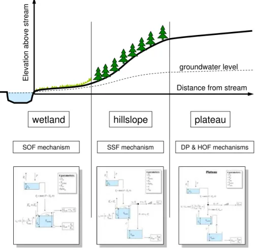
Maybe at this stage we need to better define what is meant by the terms wetland, hill slope and plateau. Here we define them in hydrological terms. A wetland stands for a hydro-logical landscape element where saturation excess overland flow (SOF) is the dominant runoff mechanism. Likewise the term hill slope stands for a hydrological landscape element where storage excess subsurface flow (SSF) is the dominant runoff mechanism. Plateau stands for hydrological landscape elements with modest slope where the groundwater table is deep and where the dominant mechanism is evaporation ex-cess deep percolation (DP). The word ’exex-cess’ indicates a threshold process.
wetland
hillslope
plateau
Distance from streamElevati
o
n above stream
groundwater level
SOF mechanism SSF mechanism DP & HOF mechanisms
Fig. 1.Model concept.
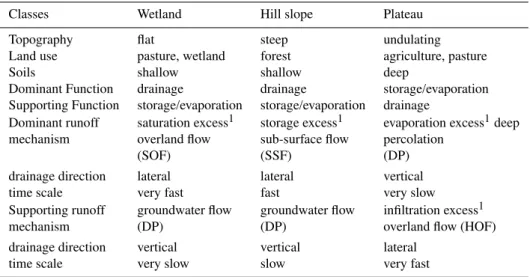
process through estimates of: permeability, storage capacity, infiltration capacity and residence times, leading to different parameter ranges. Table 1 summarises the characteristics of these three subsystems.
These three classifications are not dissimilar to the clas-sification by Winter (2001), cited above, and Scherrer and Naef (2003), who also linked them to four dominant runoff mechanisms: Saturation Overland Flow (SOF) in flat lands, SubSurface Flow (SSF) on sloping terrains with low perme-ability, Deep Percolation (DP) on permeable substratum, and Hortonian Overland Flow (HOF) where rainfall intensity ex-ceeded infiltration capacity. A similar approach was sug-gested by Uhlenbrook and Leibundgut (2002) and by Uh-lenbrook et al. (2004), who differentiated seven and eight different landscape units in a Black Forest Mountain catch-ment. Thereby, they distinguished between four different hill slope components based on their detailed geomorphological mapping. It is observed, however, that even this relatively simple distributed conceptual model suffered from equifinal-ity with poorly identifiable parameters. Here, the proposed methodology is even simpler: it has less landscape classes and considers these as lumped and parallel processes. The four different runoff processes have been attributed to the three classes: Wetland, Hill slope and Plateau (see Fig. 1).
Geomorphologists have made use of similar classifica-tions, separating between landscape elements with different slopes (e.g. Park and Van de Giesen, 2004), however, the link to lumped conceptual modelling is a new approach. In mountainous areas, it may be necessary to add a class for largely impermeable steep rock. Likewise, in permafrost ar-eas different classifications need to be made. But these are basically refinements of the general modelling approach pro-posed here.
5 Conceptual models related to three classes
Table 1.Characteristics of the Wetland–Hill slope–Plateau system.
Classes Wetland Hill slope Plateau
Topography flat steep undulating Land use pasture, wetland forest agriculture, pasture
Soils shallow shallow deep
Dominant Function drainage drainage storage/evaporation Supporting Function storage/evaporation storage/evaporation drainage
Dominant runoff saturation excess1 storage excess1 evaporation excess1deep mechanism overland flow sub-surface flow percolation
(SOF) (SSF) (DP)
drainage direction lateral lateral vertical time scale very fast fast very slow Supporting runoff groundwater flow groundwater flow infiltration excess1 mechanism (DP) (DP) overland flow (HOF)
drainage direction vertical vertical lateral time scale very slow slow very fast
1Note that the term excess indicates a threshold process.
Table 2. Parameters involved in the three sub-systems: Wetland, Hill slope and Plateau. cc means constrained calibration, fc means free calibration, mc mean manual calibration and est means esti-mated.
Model Wetland Hill slope Plateau Dominant saturation rapid sub-surface groundwater flow mechanism overland flow flow
parameters Dw[L/T], cc Dh[L/T], cc Dp[L/T], est
Sw,max[L], fc Sh,max[L], fc Su,max[L], est
βw[–], fc βh[–], fc Swp[L], est
a [–], fc p[–], est
Th[T], fc Kp[T], mc
Supporting groundwater flow groundwater flow infiltration excess mechanism flow (during high intensity rainfall) parameters Kw[T], mc Kh[T], mc Fmax[L/T], est
C[L/T], est Tp[T], est
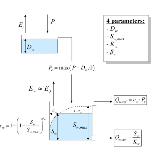
may be generated, but as an illustration these three models are further elaborated. In this example, the wetland system requires 4 parameters: an interception thresholdDw [L/T],
a maximum moisture storage before the wetland is fully sat-urated Sw,max [L], a power of the beta-function βw, and a
slow groundwater seepage residence timeKw [T]. The
lat-ter is difficult to delat-termine in isolation and may have to be estimated together with the residence time for the hill slope
Kh[T] and the plateauKp[T] (for definitions see Figs. 2–4).
I suggest to lump the groundwater system (as Fig. 1 suggests) and to estimate one lumped residence time for the groundwa-ter reservoir from the recession curve.
The daily interception threshold Dw [L/T] is here
pre-sented as a flux to be substracted from the precipitation, which is appropriate at the daily time scale (De Groen and Savenije, 2006). At shorter time scales use can be made of a Rutter model with a storage threshold (Gerrits et al., 2010). Both thresholds can be estimated from the literature or can be calibrated between well-defined constraints. There are good estimates available for canopy, forest floor, grass land and cropland interception thresholds (Gerrits et al., 2010; Gerrits, 2010). As De Groen and Savenije (2006) showed, the total amount of intercepted precipitation is not very sensitive to the threshold. The daily variability of the rainfall is far more important in determining the evaporation from interception. The same applies for the interception thresholds on the hill slope and the plateau (DhandDp). This leaves two important
calibration parameters for the wetland: the maximum sub-surface storage and the power of the beta-function. These can be calibrated on the basis of the sharp peaks shortly af-ter the rainfall has started which are generated by saturation overland flow on the riparian zone.
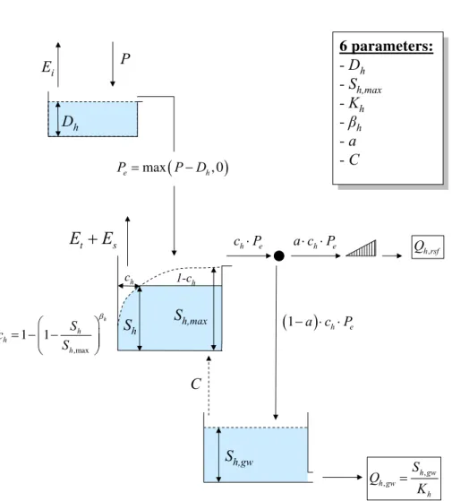
For the hill slope this leaves 4 parameters to be obtained by calibration: the maximum storage in the unsaturated zone
Sh,max[L], the power of the beta-functionβh[–],the
separa-tor between rapid subsurface flow and groundwater recharge
a [–], and the time lag for the rapid subsurface flowTh[T].
There is not much cross-correlation between these parame-ters, hence, if runoff records are available, these parameters should be identifiable. The amount of capillary riseC[L/T] needs to be estimated on the basis of the water balance of the hill slope. In principle this is not an influential parameter. If it is made a function of the moisture storage in the hill slope (Sh) then it merely functions to maintain the evaporative
D
wE
iP
,max
1
1
w w w
w
S
c
S
β
⎛
⎞
= − −
⎜
⎜
⎟
⎟
⎝
⎠
(
)
max
, 0
e w
P
=
P
−
D
,
w w gw
w
S
Q
K
=
c
w1-c
w,
w sof w e
Q
=
c
⋅
P
S
w0
w
E
≈
E
Wetland
4 parameters:
- D
w- S
w,max- K
w-
β
w4 parameters:
- D
w- S
w,max- K
w-
β
wS
w,maxFig. 2.Wetland conceptual model.
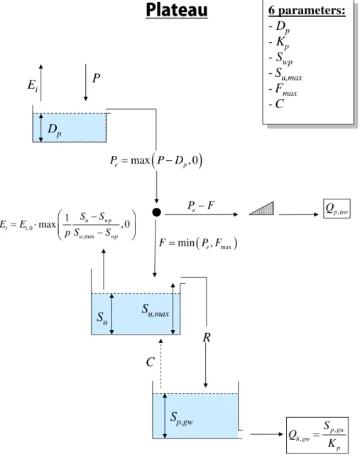
Since in this concept no substantial runoff from the plateau is expected, the parameters for the plateau should be deter-mined on the basis of soil moisture or groundwater obser-vations. If such data is not available, they need to be esti-mated. If only groundwater levels are available, then calibra-tion on the dynamics of the groundwater level fluctuacalibra-tions makes it possible to constrain the maximum soil moisture storageSu,max[L], which is the key parameter depending on
rooting depth and soil characteristics. Values for theSwp[L],
the “wilting point” and the factor determining moisture con-strained transpirationp[–] can be estimated on the basis of soil information and an estimation of the root depth. The residence time of the groundwaterKpis selected in
conjunc-tion with the residence times of the hill slope and wetland and is derived from the recession curve. The time of con-centrationTp [T] for overland flow can be estimated from
the topography. A key parameter to estimate, depending on the soil characteristics, is the maximum infiltration capac-ity Fmax [L/T], above which Hortonian overland flow
oc-curs. Of course there are uncertainties related to estimated
parameters, but these uncertainties can also be estimated on the basis of literature values and experience.
This leaves six parameters to be determined by free cali-bration (fc) and two observable parameters to be determined by constrained calibration (cc), between well-defined limits based on experiments and literature. The groundwater time scales (Kw,Kh,Kp) can be lumped and determined by
man-ual calibration (mc) on the recession curve. Hence 7 param-eters need to be estimated (est), based on literature or expe-rience (Dp,p,Su,max,Swp), experiments (Fmax), topography
(Tp) and the water balance of the hill slope (C). If necessary
plausible ranges for parameter values can be given to con-strain a calibration procedure. Possibly groundwater infor-mation can help to constrain some of the plateau parameters, particularly:Su,max, andp.
D
hE
iP
,max
1 1
h
h h
h S c
S
β
⎛ ⎞ = − −⎜⎜ ⎟⎟ ⎝ ⎠
(
)
max , 0
e h
P = P−D
ch 1-ch
h e
c ⋅P
S
ht s
E
+
E
Hillslope
6 parameters:
- D
h- S
h,max- K
h-
β
h-
a
-
C
6 parameters:
- D
h- S
h,max- K
h-
β
h-
a
-
C
h e
a c⋅ ⋅P
(
1− ⋅ ⋅a c)
h Pe, h rsf
Q
, ,
h gw h gw
h
S Q
K
=
S
h,gwC
S
h,maxFig. 3.Hill slope conceptual model.
between very fast, fast, and slower processes can focus the calibration on different processes. In principle the calibra-tion will be step-wise (e.g. Fenicia et al., 2008a), only leav-ing a limited number of parameters to be determined by (au-tomated) calibration.
If an overlay with the dominant geology is made, some parameters can be made geology-dependent, particularly the time scale parameters. The infiltration capacity can be made land-use and soil texture dependent.
Finally, it is important to keep track of the interception and soil moisture in a distributed sense, within the lumped con-ceptual approach (so we account the moisture in a distributed way, as a response to distributed rainfall, but the parameters remain lumped). In fact the approach requires an overlay of topography, geology, land use and climatic drivers over a simple conceptual model structure.
6 Is there connectivity between these hydrological
landscapes?
D
pE
iP
(
)
max
, 0
e p
P
=
P
−
D
Plateau
6 parameters:
- D
p- K
p- S
wp-
S
u,max-
F
max-
C
6 parameters:
- D
p- K
p- S
wp-
S
u,max-
F
max-
C
e
P
−
F
,
p ieo
Q
, ,
p gw h gw
p
S
Q
K
=
S
p,gwC
(
max)
min e,F= P F
R
,0
,max 1
max u wp , 0
t t
u wp
S S E E
p S S
⎛ − ⎞
= ⋅ ⎜⎜ ⎟⎟
−
⎝ ⎠
S
u,maxS
uFig. 4.Plateau conceptual model.
the drainage system expands (Winsemius et al., 2006). So whether there is significant connectivity or not depends on the local conditions, and depending on the local conditions different conceptual model structures need to be tested. In the Meuse catchment, for instance, the hill slopes discharge directly to the stream, without passing through the ground-water system. The plateaus feed the groundground-water which dis-charges directly to the stream. There may be some intercep-tion in the intersecintercep-tion with the hill slope, but this is probably minor. One can also safely assume that the recharge on the wetland itself raises the groundwater level to saturation ear-lier than the groundwater flow from the plateau or the hill slope, where there is probably a longer delay between rain-fall and recharge. So in my example the processes are not
7 How to test the new approach?
As soon as we launch a new approach, it is fair to ask how we can test whether the approach is better than another – more conventional - one. The proof of the pudding is in the eat-ing and we have to set-up an objective way of proofeat-ing “the pudding”. Here we touch upon a fundamental problem in hydrology where an objective proof is hard to get. In catch-ment hydrology we always suffer from the problem that we do not know – with sufficient accuracy – what the exact forc-ing of the system was. Rainfall is highly heterogeneous in space, and point measurements can result in substantial bi-ases. Maybe in the near future, making better use of radar and remote sensing instruments, we shall be able to reduce these biases, but with an uncertain forcing of a model it is extremely hard to reject or accept a hypothesis.
Clearly there is no such thing as the correct or “best” model. In absolute terms, such a model most likely is not available under the given circumstances (cf. Andr´eassian et al., 2009). We should instead strive to develop “better” mod-els than those available to date (Savenije, 2009). A model (hypothesis) that performs consistently better than another model (hypothesis) is most likely a better hypothesis. Al-though such a conclusion may be very site and case specific. As a result we have to ask ourselves how broad a sample should be (consisting of various catchments in different cli-matic, geological and topographical conditions and/or vari-ous climatically different calibration and test periods) in or-der to be able to draw the conclusion that one model is better than the other.
Assuming that we have a broad enough sample, how do we test different model structures and parameterizations? And how do we conclude that a model is “better” or more ad-equate than another? A powerful tool to identify model im-provement is multi-objective calibration. Objective functions emphasizing, for example, peak as well as low flow can be used to generate pareto fronts of model parameterizations (Fenicia et al., 2008a). Shifts of these pareto fronts towards the origin illustrate improvements in model structures, while structures and parameterizations whose objective functions plot far from the pareto optimal solution can be rejected.
Clearly, there remains a level of subjectivity in such an approach. However, in conjunction with a rigorous model crash test as suggested by Klemes (1986) and reiterated by Andreassian et al. (2009), there can be some confidence that a chosen model can adequately represent the processes in a given catchment. The mentioned model crash test in-volves several levels of model testing, including common split-sample tests, followed by differential split sample tests, proxy-basin tests and proxy-basin differential split sample tests (Klemes, 1986). In order to extract even more in-formation about the adequacy of the respective models one could extend the concept of differential split sample tests. That is, instead of merely identifying a few periods of dif-ferent climatic conditions for sequential model calibrating
and testing, the concept of re-sampling (in a way similar to “boot-strapping”) could be adopted to increase the sample sizes and therefore the information content of the tests. For example, from the available data record with lengthn, the model could be sequentially calibrated for one hydrological year (or any other chosen period) and thereafter the param-eterization could be tested individually for all preceding and subsequentn−1 years (or any other chosen periods). This is
then repeated by calibrating the model to another hydrologi-cal year and testing it on the remainingn−1 years, until the
model has been calibrated for all individualnyears.
It is always better to evaluate model performance under validation circumstances and not under calibration circum-stances. The ratio of the calibration performance to vali-dation performance could be an interesting indicator for the predictive uncertainty of a model. Model structures that do not perform significantly better than a bench mark model or another model structure should be rejected. For bench-mark models one could consider well established parsimo-nious conceptual models such as HBV (Bergstr¨om, 1992) or GR4J (Perrin et al., 2003).
The ensemble of tests would not only identify adequate model structures but also provide insight into temporal and spatial model transposability. Most importantly, it would be possible to identify under which climatic and topographic circumstances which model structures fail, allowing us to identify weaknesses in model structures and potentially giv-ing the modeler the possibility to adjust model structures ac-cording to the observed weaknesses (Fenicia et al., 2008a).
8 Conclusion
complexity and simplicity, making use of the patterns inher-ent in the landscape. I have purposely not yet tested the ap-proach on specific catchments or situations. That would only divert the attention from the opinion forming character of this paper and lead to a discussion on which model best fits the hydrographs (Sivapalan, 2009). In my view, testing it and refining it is an interesting venue for further research. More importantly, this modelling approach should be seen as an in-strument for learning and for testing hypotheses (Fenicia et al., 2008b), within a framework of observable topographical characteristics.
Finally, it needs to be stressed that this approach is not another conceptual model but a framework to develop appro-priate model structures for the problem at hand, making use of topographic information to distinguish between dominant hydrological processes. It is not a straightjacket that is con-fined by a predecon-fined model structure. Model structures are flexible in the way as proposed by Fenicia et al. (2008a,b, 2010). Through this flexible approach conceptual models can be developed for different climatic, geologic and land-use conditions, making land-use of the information available in the topography.
Acknowledgements. I would like to thank the inputs provided by several people with whom I shared these ideas over the past year. Some of them have made very detailed suggestions while commenting on a draft version, others have shared their valuable views with me during discussions. I would like to mention in particular: Jeff Mc Donnell, Erwin Zehe, Fabrizio Fenicia, Nick van de Giesen, Markus Hrachowitz and Murugesu Sivapalan, I owe them a lot. Also I would like to refer to the interesting discussion that too place in HESSD, which helped me to improve this paper and to clarify many points. I would like to thank the referees and discussants for their constructive criticism. Of course, if the reader finds fault with this paper, then please blame me and not the people who have been so kind to share their views with me.
Edited by: E. Zehe
References
Andr´eassian, V., Perrin, C., Berthet, L., Le Moine, N., Lerat, J., Loumagne, C., Oudin, L., Mathevet, T., Ramos, M.-H., and Val´ery, A.:HESS Opinions“Crash tests for a standardized eval-uation of hydrological models”, Hydrol. Earth Syst. Sci., 13, 1757–1764, doi:10.5194/hess-13-1757-2009, 2009.
Bergstr¨om, S.: The HBV model – its structure and applications, SMHI Reports RH 4, 1992.
Beven, K.: On landscape space to model space mapping, HP today, Hydrol. Process., 15, 323–324, 2001.
Beven, K. J. and Kirkby, M. J.: A physcally based, variable con-tributing area model of basin hydrology, Hydrol. Sci. Bull., 24, 43–69, 1979.
Brooks, J. R., Barnard, H. R., Coulombe, R., and McDonnell, J. J.: Ecohydrological separation of water between trees and streams in a Mediterranean climate, Nat. Geosci., 3, 100–104, doi:10.1038/NGEO722, 2010.
De Groen, M. M. and Savenije, H. H. G.: A monthly in-terception equation based on the statistical characteristics of daily rainfall, Water Resour. Res., 42, 1–10, W12417, doi:10.1029/2006WR005013, 2006.
Dooge, J. C. I.: Looking for Hydrologic Laws, Water Resour. Res., 22(9), S46–S58, 1986.
Dooge, J. C. I.: Searching for simplicity, Surv. Geophys., 18, 511– 534, 1997.
Dooge, J. C. I.: Bringing it all together, Hydrol. Earth Syst. Sci., 9, 3–14, doi:10.5194/hess-9-3-2005, 2005.
Fenicia, F., Savenije, H. H. G., Matgen, P., and Pfister, L.: Understanding catchment behavior through stepwise model concept improvement, Water Resour. Res., 44, W01402, doi:10.1029/2006WR005563, 2008a.
Fenicia, F., McDonnell, J. J., and Savenije, H. H. G.: Learn-ing from model improvement: On the contribution of comple-mentary data to process understanding, Water Resour. Res., 44, W06419, doi:10.1029/2007WR006386, 2008b.
Fenicia, F., Savenije, H. H. G., and Hoffmann, L.: An approach for matching accuracy and predicitve capability in hydrological model development, IAHS-AISH P., 338, 91–99, 2010. Gerrits, A. M. J.: The role of interception in the hydrological cycle,
PhD thesis, Delft University of Technology, Delft, 2010. Gerrits, A. M. J., Pfister, L., and Savenije, H. H. G.: Spatial
and temporal variability of canopy and forest floor intercep-tion in a beech forest, Hydrol. Process., 24 (21), 3011–3025, doi:10.1002/hyp.7712, 2010.
Hellebrand, H. and Van den Bos, R.: Investigating the use of spa-tial discretization of hydrological processes in conceptual rainfall runoff modelling: a case study for the meso scale, Hydrol. Pro-cess. 22, 2943–2952, 2008.
Klemes, V.: Operational testing of hydrological simulation models, Hydrolog. Sci. J., 31(1), 13–24, 1986.
McDonnell, J. J., Sivapalan, M., Vache, K., Dunn, S., Grant, G., Haggerty, R., Hinz, C., Hooper, R., Kirchner, J., Roderick, M. L., Selker, J., and Weiler, M.: Moving beyond heterogeneity and process complexity: A new vision for watershed hydrology, Water Resour. Res., 43, W07301, doi:10.1029/2006WR005467, 2007.
Park, S. J. and van de Giesen, N.: Soil-landscape delineation to de-fine spatial samping domains for hill slope hydrology, J. Hydrol., 295, 28–46, 2004.
Perrin, C., Michel, C., and Andreassian, V.: Improvement of a parsi-monious model for streamflow simulation, J. Hydrol., 279, 275– 289, 2003.
Renn´o, C. D., Nobre, A. D., Cuartas, L. A., Soares, J. V., Hod-nett, M. G., Tomasella, J., and Waterloo, M. J.: HAND, a new terrain descriptor using SRTM-DEM: Mapping terra-firme rain-forest environments in Amazonia, Remote Sens. Environ., 112, 3469–3481, 2008.
Rosin, K.: Development, evaluation and application of domi-nant runoff generation processes in hydrological modeling, Doc-toral thesis, University of British Columbia, Vancouver, Canada, 2010.
Scherrer, S. and Naef, F.: A decision scheme to indicate dominant hydrological flow processes on temperate grassland, Hydrol. Pro-cess., 17, 391–401, 2003.
Seibert, J. and McDonnell, J. J.: On the dialog between experi-mentalist and modeler in catchment hydrology: Use of soft data for multicriteria model calibration, Water Resour. Res., 38(11), 1241, doi:10.1029/2001WR000978, 2002.
Sivapalan, M.: The secret to “doing better hydrological science”: change the question!, Hydrol. Process., 23, 1391–1396, 2009. Uchida, T., Tromp-van Meerveld, I., and McDonnell, J. J.: The role
of lateral pipe flow in hillslope runoff response: An intercompar-ison of nonlinear hillslope response, J. Hydrol., 311, 117–133, 2005.
Uhlenbrook, S. and Leibundgut, Ch.: Process-oriented catchment modelling and multiple-response validation, Hydrol. Process., 16, 423–440, 2002.
Uhlenbrook, S., Roser, S., and Tilch, N.: Hydrological process rep-resentation at the meso-scale: the potential of a distributed, con-ceptual catchment model, J. Hydrol., 291, 278–296, 2004. Winsemius, H. C., Savenije, H. H. G., Gerrits, A. M. J., Zapreeva,
E. A., and Klees, R.: Comparison of two model approaches in the Zambezi river basin with regard to model reliability and identifi-ability, Hydrol. Earth Syst. Sci., 10, 339–352, doi:10.5194/hess-10-339-2006, 2006.
Winter, T. C.: The concept of hydrologic landscapes, J. Am. Water Resour. Assoc., 37(2), 335–349, 2001.
Zehe, E. and Sivapalan, M.: Threshold behaviour in hydrologi-cal systems as (human) geo-ecosystems: manifestations, con-trols, implications, Hydrol. Earth Syst. Sci., 13, 1273–1297, doi:10.5194/hess-13-1273-2009, 2009.