HESSD
7, 4635–4656, 2010Topography driven conceptual modelling
(FLEX-Topo)
H. H. G. Savenije
Title Page
Abstract Introduction
Conclusions References
Tables Figures
◭ ◮
◭ ◮
Back Close
Full Screen / Esc
Printer-friendly Version Interactive Discussion
Discussion
P
a
per
|
Dis
cussion
P
a
per
|
Discussion
P
a
per
|
Discussio
n
P
a
per
|
Hydrol. Earth Syst. Sci. Discuss., 7, 4635–4656, 2010 www.hydrol-earth-syst-sci-discuss.net/7/4635/2010/ doi:10.5194/hessd-7-4635-2010
© Author(s) 2010. CC Attribution 3.0 License.
Hydrology and Earth System Sciences Discussions
This discussion paper is/has been under review for the journal Hydrology and Earth System Sciences (HESS). Please refer to the corresponding final paper in HESS if available.
HESS Opinions
“Topography driven conceptual
modelling (FLEX-Topo)”
H. H. G. Savenije
Delft Univ. of Technology, Water Resources, P.O. Box 5048, 2600 GA Delft, The Netherlands
Received: 3 July 2010 – Accepted: 6 July 2010 – Published: 15 July 2010
Correspondence to: H. H. G. Savenije ([email protected])
HESSD
7, 4635–4656, 2010Topography driven conceptual modelling
(FLEX-Topo)
H. H. G. Savenije
Title Page
Abstract Introduction
Conclusions References
Tables Figures
◭ ◮
◭ ◮
Back Close
Full Screen / Esc
Printer-friendly Version Interactive Discussion
Discussion
P
a
per
|
Dis
cussion
P
a
per
|
Discussion
P
a
per
|
Discussio
n
P
a
per
Abstract
Heterogeneity and complexity of hydrological processes offer substantial challenges to the hydrological modeller. Some hydrologists try to tackle this problem by introducing more and more detail in their models, or by setting-up more and more complicated models starting from basic principles at the smallest possible level. As we know, this
5
reductionist approach leads to ever higher levels of equifinality and predictive uncer-tainty. On the other hand, simple, lumped and parsimonious models may be too simple to be realistic or representative of the dominant hydrological processes. In this com-mentary, a new model approach is proposed that tries to find the middle way between complex distributed and simple lumped modelling approaches. Here we try to find the
10
right level of simplification while avoiding over-simplification. Paraphrasing Einstein, the maxim is: make a model as simple as possible, but not simpler than that. The ap-proach presented is process based, but not physically based in the traditional sense. Instead, it is based on a conceptual representation of the dominant physical processes in certain key elements of the landscape. The essence of the approach is that the
15
model structure is made dependent on a limited number of landscape classes in which the topography is the main driver, but which can include geological, geomorphological or land-use classification. These classes are then represented by lumped conceptual models that act in parallel. The advantage of this approach over a fully distributed con-ceptualisation is that it retains maximum simplicity while taking into account observable
20
landscape characteristics.
1 What is the issue?
The hydrological world is complex and heterogeneous. Yet we know that the reduc-tionist approach: combining so-called physically based small scale basic principles (such as the Darcy, Richards, and Navier-Stokes equations) with detailed distributed
25
HESSD
7, 4635–4656, 2010Topography driven conceptual modelling
(FLEX-Topo)
H. H. G. Savenije
Title Page
Abstract Introduction
Conclusions References
Tables Figures
◭ ◮
◭ ◮
Back Close
Full Screen / Esc
Printer-friendly Version Interactive Discussion
Discussion
P
a
per
|
Dis
cussion
P
a
per
|
Discussion
P
a
per
|
Discussio
n
P
a
per
|
methods ill account for heterogeneity, preferential pathways and structural patterns on and under the surface. This approach is a dead-end street, as has been observed by many (e.g. McDonnell et al., 2007). At the same time, we know that – in view of the high apparent complexity – hydrological behaviour is often unexpectedly simple, whereby parsimonious conceptual models often outperform much more complex ones,
5
and with much less predictive uncertainty. Apparently, catchments are intermediate systems: highly heterogeneous systems with some degree of organisation (Dooge, 1986), where relatively simple models can do the trick. Catchments belong to the realm of organised complexity (Dooge, 2005). Simple catchment-scale models appar-ently make use of emerging patterns of self-organisation implicit in naturally formed
10
catchments and river basins.
But obviously we cannot be satisfied by this. On the one hand we need simplicity, but on the other hand there is a limit to how simple a model can be (e.g. Dooge, 1997). Simple relationships that behave well in a certain catchment under certain conditions may be useless elsewhere or under different hydrological conditions. Prediction in
15
ungauged basins requires that the relationships found can be transferred, and hence that they are based on objective and physically observable characteristics.
Obviously topography is such a characteristic. Distributed models make use of to-pography, but in a rather unsophisticated way: as brute force. It would be much more fitting to extract from the topography the signatures of the landscape and to translate
20
these into a conceptual architecture. This is not dissimilar to what Beven (2001) sug-gested when he said that landscape characteristics need to be mapped into conceptual structures and relationships.
The reason why we model is because we want to predict hydrological behaviour under unknown circumstances: either to predict an uncertain future in a gauged
catch-25
HESSD
7, 4635–4656, 2010Topography driven conceptual modelling
(FLEX-Topo)
H. H. G. Savenije
Title Page
Abstract Introduction
Conclusions References
Tables Figures
◭ ◮
◭ ◮
Back Close
Full Screen / Esc
Printer-friendly Version Interactive Discussion
Discussion
P
a
per
|
Dis
cussion
P
a
per
|
Discussion
P
a
per
|
Discussio
n
P
a
per
2 The role of topography
In solving this question, we need to zoom-out and apply a giant’s view, where we model the dominant processes at the relevant scale. The reductionist view of the ant, who observes physical processes at a microscopic scale, does not lead to predictive equations at the relevant scale of the catchment, mainly due to heterogeneity and the
5
disregard of large-scale patterns (Savenije, 2009). Conversely, we need to model our catchments at the macro-scale based on macro-scale observables, one of which is the organisation of the landscape into topographically controlled “functional units”, as discussed by Zehe and Sivapalan (2009).
Indeed, there is a lot of heterogeneity: in the landscape, in the soil, in the terrain, and
10
in the rainfall. But at larger scales there are patterns with strikingly simple emergent behaviour. Or is this a coincidence? When driving through the European landscape, a well-developed landscape intensively used for agriculture, forestry and settlements, it occurred to me that hill slopes are mostly forested while the undulating plateaus with their modest slopes are used for agriculture. Where hill slopes are cultivated,
15
they are generally used for fruit trees or vineyards, but the dominant land use of hill slopes is forest. The wetlands close to the rivers are not forested (since trees require unsaturated soils during most of the time). They are generally used for agriculture (seasonal crops), pasture or as wetland areas. Settlements occur both in the riparian zones and on the plateaus, while roads cut through the hill slopes. But the overall
20
picture is: agriculture on the plateaus, forests on the hill slopes and meadows and wetlands on the riparian zones.
At the same time, I have always had the feeling that forests are key to the hydrological dynamics of the European rivers, even though the area occupied by forests is seldom large. While driving through the French landscape and seeing the dense forests on
25
HESSD
7, 4635–4656, 2010Topography driven conceptual modelling
(FLEX-Topo)
H. H. G. Savenije
Title Page
Abstract Introduction
Conclusions References
Tables Figures
◭ ◮
◭ ◮
Back Close
Full Screen / Esc
Printer-friendly Version Interactive Discussion
Discussion
P
a
per
|
Dis
cussion
P
a
per
|
Discussion
P
a
per
|
Discussio
n
P
a
per
|
be dominated by erosion and badlands), and much of the Hortonian overland flow is re-infiltrated downslope. The processes on the plateaus are mainly vertical, where rainfall is to a large extent balanced by evaporation, with the remainder recharging the groundwater. This groundwater partly ends up in the river as base flow but is also intercepted by the forests on the hill slope, reducing the drainage from the plateau even
5
more. As a result the amount of groundwater from the plateau reaching the stream is probably small, particularly if the distance to the stream is large.
The floods, however, and most of the runoff dynamics are generated on the hill slopes, and these are mostly forested (sometimes planted with fruit trees or vineyards). This implies that forests could very well be the dominant land cover when studying flood
10
generation or when performing flood forecasting. In this regard it is worrying that not many rainfall stations are located in forests, on hill slopes, or in mountainous areas. The riparian zones, although they may be responsible for the early flood response through saturation overland flow, due to their limited extent and modest slope, are not the largest contributor to flood volumes.
15
For a forest ecosystem to survive on a hill slope there are two important life-support functions which seem to be contradicting. One is drainage, the other is moisture reten-tion. Excess water needs to be drained offso as to maintain an aerated soil. However drainage needs to take place in a way that it does not erode the foundation of the ecosystem and in a way that enough moisture is retained to bridge dry spells.
Sub-20
surface drainage through preferential pathways is the most efficient mechanism in this regard. It does not cause excessive erosion and it allows the wetting of stagnant pock-ets in the soil from which the roots can tap their water. Zehe et al. (2010) demonstrated that this combination of wetting and preferential sub-surface drainage is the most effi -cient mechanism to achieve maximum entropy, which has evolved over time.
25
HESSD
7, 4635–4656, 2010Topography driven conceptual modelling
(FLEX-Topo)
H. H. G. Savenije
Title Page
Abstract Introduction
Conclusions References
Tables Figures
◭ ◮
◭ ◮
Back Close
Full Screen / Esc
Printer-friendly Version Interactive Discussion
Discussion
P
a
per
|
Dis
cussion
P
a
per
|
Discussion
P
a
per
|
Discussio
n
P
a
per
plateau during dry periods, which implies that the moisture retention function of the hill slope becomes less important, in favour of the drainage function. Hence, the runoff coefficient of hill slopes is high, higher than the vertical water balance of the hill slope (rainfall minus evaporation) would suggest.
On top of this, as JeffMcDonnell has often stated, hill slopes tend to behave
sim-5
ilarly all over the world. The ecosystems on hill slopes have created an environment where sub-surface drainage is the dominant feature. This is a logical arrangement for ecosystem survival. Surface runoff would erode the mere basis for the ecosystem, while water logging would make it impossible for most plant species to survive. Only a system of sub-surface drainage that exceeds a certain storage threshold, which the
10
ecosystem would need to retain, is the hydrological mechanism that can support an ecosystem. Such a system, termed by JeffMcDonnell during his Dalton lecture (2009) as “Storage Excess Subsurface flow”, is a mechanism that occurs throughout the world in different ecosystems, different geologies and different climates. This is the dominant rainfall-runoffmechanism on hill slopes. This sub-surface drainage mechanism through
15
preferential pathways also supports the moisture retention function of the hill slope, so that the hill slope facilitates the two essential functions: drainage and moisture reten-tion.
In the riparian zone, obviously, the dominant mechanism is saturation excess over-land flow. In these areas where slopes are modest, open water is near and, hence, the
20
groundwater level is close to the surface, the amount of soil moisture storage available is small. After continued rainfall, an ever-increasing part of the riparian zone will be-come saturated, partly because of hill slope and plateau groundwater contributing, and saturation overland flow will feed the streams.
The plateaus, on the other hand, don’t take an active part in the rainfall-runoff
be-25
ground-HESSD
7, 4635–4656, 2010Topography driven conceptual modelling
(FLEX-Topo)
H. H. G. Savenije
Title Page
Abstract Introduction
Conclusions References
Tables Figures
◭ ◮
◭ ◮
Back Close
Full Screen / Esc
Printer-friendly Version Interactive Discussion
Discussion
P
a
per
|
Dis
cussion
P
a
per
|
Discussion
P
a
per
|
Discussio
n
P
a
per
|
water is deep, water table slopes are modest. In addition, underlying rock may have low lateral permeability and the
groundwater reservoir may supply water to the forest that grows on the hill slopes. As a result, the groundwater contribution from the plateaus to runoffis small. One may expect that highland plateaus with relatively cool climates have a higher contribution to
5
base flow than the warmer plateaus at lower elevations. In general, the hydrological process on the plateau is predominantly vertical while the lateral flow component is small with long residence times.
Mutatis mutandis, the same applies to all other intensively inhabited regions of the world. Steep hill slopes are not much use for agriculture and are often forested,
ei-10
ther by natural forests, production forests or plantations. Riparian zones are used for pasture or seasonal agriculture. Even in Africa, where I have worked for many years, the situation is not much different, albeit that the plateaus are also often forested, but that does not change the image that plateaus hardly generate lateral runoff and that forested hill slopes determine both the flood behaviour and the water resources
avail-15
ability. Hence also in natural environments, forested hill slopes host the dominant drainage processes. In modelling the runoffbehaviour of the Zambezi basin, we re-alised that less than 10% of the groundwater reservoir is active in the rainfall-runoff
process (Winsemius et al., 2006). This is the groundwater situated in the near-stream hill-slopes.
20
3 The role of geology and climate
Until now, we have discussed topography as the main driver of hydrological behaviour. But what is the role of geology? And how important is the spatial distribution of the rainfall and other climatic factors? In an evolutionary sense, geology is less important than it appears at first sight. As stated before, hill slopes behave very similarly all over
25
HESSD
7, 4635–4656, 2010Topography driven conceptual modelling
(FLEX-Topo)
H. H. G. Savenije
Title Page
Abstract Introduction
Conclusions References
Tables Figures
◭ ◮
◭ ◮
Back Close
Full Screen / Esc
Printer-friendly Version Interactive Discussion
Discussion
P
a
per
|
Dis
cussion
P
a
per
|
Discussion
P
a
per
|
Discussio
n
P
a
per
system that conceptually functions as a “storage excess subsurface flow” system. If they had not developed sub-surface drainage, they would have disappeared due to the erosion that results from Hortonian overland flow. So the mature hill slopes that we see have survived as a result of the sub-surface drainage structure, in symbiosis with the ecosystem living on it. Of course there are also hill slopes that are barren, such as in
5
deserts. The dominant mechanism there is most probably Hortonian overland flow, as there is no ecosystem that facilitated the formation of sub-surface drainage. Although the conditions under which they were originally shaped may have been quite different under different climatic conditions. So, in arid climates where ecosystems have not had the opportunity to maintain themselves, the dominant mechanism on hill slopes is
10
probably Hortonian overland flow.
If sub-surface drainage is present in all vegetated hill slopes, then the role of ge-ology is probably limited to the interaction with deeper groundwater layers and to the feasible parameter ranges. For instance, Fenicia et al. (2010) showed that for diff er-ent catchmer-ents in Luxembourg, having very distinct geological properties (e.g. one in
15
schist, one in sand stone and one in marl), similar model approaches for rapid subsur-face flow could be used, but that the main differences between the catchments were in the interaction with the groundwater (in schist and marl this interaction is almost non-existent, whereas in sandstone it is the dominant mechanism) and in the parameter ranges.
20
The role of climate is that it facilitates the ecosystem to survive and to develop its substratum in an evolutionary process that shapes both the drainage and the retention function. So in certain climates we will find different dominant processes. But there is more. The spatial variability of climatic factors can have an important influence on hydrological behaviour. For instance the different radiation levels related to the aspect
25
HESSD
7, 4635–4656, 2010Topography driven conceptual modelling
(FLEX-Topo)
H. H. G. Savenije
Title Page
Abstract Introduction
Conclusions References
Tables Figures
◭ ◮
◭ ◮
Back Close
Full Screen / Esc
Printer-friendly Version Interactive Discussion
Discussion
P
a
per
|
Dis
cussion
P
a
per
|
Discussion
P
a
per
|
Discussio
n
P
a
per
|
is key to the spatial variability of climatic factors. What appears to be essential in hydrological modelling, however, is to account for the spatial variability of precipitation and moisture levels in a distributed way. Fenicia (2008a) demonstrated that much better model performance is achieved when moisture is accounted for in a distributed sense, while the model structure and related parameters remain lumped at sub-basin scale.
5
So there are three elements that need to be explored further. First of all we need to obtain maximum information from the topography, whereby: 1) we use topography to distinguish the dominant mechanisms (e.g. by distinguishing between wetlands, hill slopes and plateaus); 2) we use topography as a proxy for climatic variability (precipita-tion, temperature, radiation); and 3) we use topography for the derivation of pathways
10
and travel times. Next, we need to derive information form the geology to confirm model structures (e.g. the importance of groundwater to the drainage function) and to constrain viable parameter ranges. Finally, we need to account for the spatial variability of precipitation by distributed accounting of moisture levels.
4 Classification based on topography with respect to nearest open water 15
The question is whether this simple “riparian zone-hill slope-plateau” concept is a con-cept that is useful in the “mapping” between the heterogeneous reality and the much simpler conceptual world of the hydrological model.
It is logical to base a classification system on the topography. With modern tech-nology topographical signatures can be determined accurately. Renn ´o et al. (2008)
20
developed an algorithm, named HAND (Height Above Nearest Drainage), based on topographical information from the Shuttle Radar Topographical Mission (SRTM) to derive maps with detailed terrain elevation above the nearest open water (first order channels). They combined these observations into distribution functions relating to-pography to distance from the nearest stream. From this information, wetland areas,
25
HESSD
7, 4635–4656, 2010Topography driven conceptual modelling
(FLEX-Topo)
H. H. G. Savenije
Title Page
Abstract Introduction
Conclusions References
Tables Figures
◭ ◮
◭ ◮
Back Close
Full Screen / Esc
Printer-friendly Version Interactive Discussion
Discussion
P
a
per
|
Dis
cussion
P
a
per
|
Discussion
P
a
per
|
Discussio
n
P
a
per
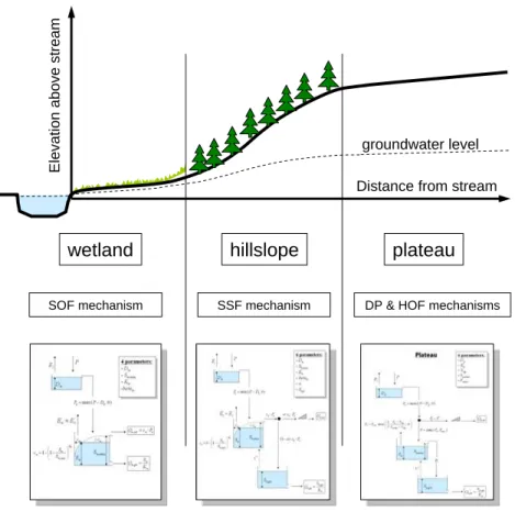
Figure 1 is based on Renn ´o et al. (2008). It shows how the elevation above the nearest stream and the distance of the pixel to the nearest stream generates a pat-tern where the inflection points determine the limits between wetland, hill slope and plateau. Each of these sub-systems should have its own conceptual model structure. If information is available on the geology of the substratum, then the geology can
pro-5
vide indications for the strength of the dominant hydrological process through estimates of: permeability, storage capacity, infiltration capacity and residence times, leading to different parameter ranges. Table 1 summarises the characteristics of these three sub-systems.
These three classifications are not dissimilar to the classification by Scherrer and
10
Naef (2003), who identified four major classes: Saturation Overland Flow (SOF) in flat lands, SubSurface Flow (SSF) on sloping terrains with low permeability, Deep Percola-tion (DP) on permeable substratum, and Hortonian Overland Flow (HOF) where rainfall intensity exceeded infiltration capacity. A similar approach was suggested by Uhlen-brook and Leibundgut (2002) and by UhlenUhlen-brook et al. (2004), who differentiated seven
15
and eight different landscape units in a Black Forest Mountain catchment. Thereby, they distinguished between four different hill slope components based on their detailed geomorphological mapping. It is observed, however, that even this relatively simple distributed conceptual model suffered from equifinality with poorly identifiable parame-ters. Here, the proposed methodology is even simpler: it has less landscape classes
20
and considers these as lumped and parallel processes. The four different runoff pro-cesses have been attributed to the three classes: Wetland, Hill slope and Plateau (see Fig. 1).
Geomorphologists have made use of similar classifications, separating between landscape elements with different slopes (e.g. Park and Van de Giesen, 2004),
how-25
HESSD
7, 4635–4656, 2010Topography driven conceptual modelling
(FLEX-Topo)
H. H. G. Savenije
Title Page
Abstract Introduction
Conclusions References
Tables Figures
◭ ◮
◭ ◮
Back Close
Full Screen / Esc
Printer-friendly Version Interactive Discussion
Discussion
P
a
per
|
Dis
cussion
P
a
per
|
Discussion
P
a
per
|
Discussio
n
P
a
per
|
material. Also in mountainous areas, it may be necessary to add a class for largely impermeable steep rock. But these are basically refinements of the general modelling approach proposed here.
5 Conceptual models related to three classes
So, as an example of the methodology, let’s limit the approach to the three sub-systems
5
wetland-hill slope-plateau. Each of the three hydrological sub-systems have their own model structure that should reflect the structure of these sub-systems in the real world. Figures 2–4 give examples of what these conceptual models may look like, each with their equations and parameters. The parameters are summarised in Table 2. Of course other conceptualisations may be generated, but as an illustration these three models
10
are further elaborated. In this example, the wetland system requires 4 parameters: an interception thresholdDw[L], a maximum moisture storage before the wetland is fully saturatedSw,max[L], a power of the beta-functionβw, and a slow groundwater seepage residence timeKw [T]. The latter is difficult to determine in isolation and may have to be estimated together with the residence time for the hill slopeKh[T] and the plateau
15
Kp[T]. I suggest to lump the groundwater system (as Fig. 1 suggests) and to estimate one lumped residence time for the groundwater reservoir from the recession curve. The daily interception thresholdDw [L/T] can be estimated from the literature or can be calibrated between well-defined constraints. There are good estimates available for canopy, forest floor, grass land and cropland interception thresholds (Gerrits et al.,
20
2010; Gerrits, 2010). As De Groen and Savenije (2006) showed, the model is not very sensitive to this threshold. The daily variability of the rainfall is far more important in determining the evaporation from interception. The same applies for the interception thresholds on the hill slope and the plateau (DhandDp). This leaves two important cal-ibration parameters for the wetland: the maximum sub-surface storage and the power
25
HESSD
7, 4635–4656, 2010Topography driven conceptual modelling
(FLEX-Topo)
H. H. G. Savenije
Title Page
Abstract Introduction
Conclusions References
Tables Figures
◭ ◮
◭ ◮
Back Close
Full Screen / Esc
Printer-friendly Version Interactive Discussion
Discussion
P
a
per
|
Dis
cussion
P
a
per
|
Discussion
P
a
per
|
Discussio
n
P
a
per
after the rainfall has started which are generated by saturation overland flow on the riparian zone.
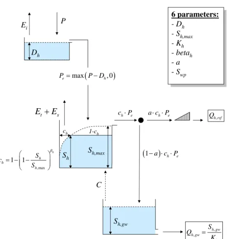
For the hill slope this leaves 4 parameters to be obtained by calibration: the maximum storage in the unsaturated zone Sh,max [L], the power of the beta-function βh [–],the separator between rapid subsurface flow and groundwater rechargea[–], and the time
5
lag for the rapid subsurface flow Th [T]. There is not much cross-correlation between these parameters, hence, if runoffrecords are available, these parameters should be identifiable. The amount of capillary rise needs to be estimated on the basis of the water balance of the hill slope. In principle this is not an influential parameter. If it is made a function of the moisture storage in the hill slope (Sh) then it merely functions to
10
maintain the evaporative capacity of the forest.
Since in this concept no substantial runofffrom the plateau is expected, the param-eters for the plateau can’t be calibrated. They need to be estimated. If groundwater levels are available, then calibration on the dynamics of the groundwater level fluctu-ations makes it possible to constrain the maximum soil moisture storage Su,max [L],
15
which is the key parameter depending on rooting depth and soil characteristics. Val-ues for theSwp [L], the “wilting point” and the factor determining moisture constrained transpirationp[–] can be estimated on the basis of soil information and an estimation of the root depth. The residence time of the groundwaterKpis selected in conjunction with the residence times of the hill slope and wetland and is derived from the
reces-20
sion curve. The time of concentrationTp [T] for overland flow can be estimated from the topography. A key parameter to estimate, depending on the soil characteristics, is the maximum infiltration capacity Fmax [L/T], above which Hortonian overland flow occurs. Of course there are uncertainties related to estimated parameters, but these uncertainties can also be estimated on the basis of literature values and experience.
25
HESSD
7, 4635–4656, 2010Topography driven conceptual modelling
(FLEX-Topo)
H. H. G. Savenije
Title Page
Abstract Introduction
Conclusions References
Tables Figures
◭ ◮
◭ ◮
Back Close
Full Screen / Esc
Printer-friendly Version Interactive Discussion
Discussion
P
a
per
|
Dis
cussion
P
a
per
|
Discussion
P
a
per
|
Discussio
n
P
a
per
|
Hence 7 parameters need to be estimated (est), based on literature or experience (Dp, p,Su,max, Swp), experiments (Fmax), topography (Tp) and the water balance of the hill slope (C). If necessary plausible ranges for parameter values can be given to constrain a calibration procedure. Possibly groundwater information can help to constrain some of the plateau parameters, particularly:Su,max, andp.
5
This turns the method into a six-parameter calibration process. By considering dif-ferent catchments with different proportions of Wetland, Hill slope and Plateau, focus on different parameters can be given, which allows further insight into the appropriate parameter values. Also distinguishing between very fast, fast, and slower processes can focus the calibration on different processes. In principle the calibration will be
step-10
wise (e.g. Fenicia et al., 2008a), only leaving a limited number of parameters to be determined by (automated) calibration.
Initially, it is proposed to model the three sub-models in parallel, but it may be neces-sary to treat them in series or to transfer water from one sub-system into the other. If an overlay with the dominant geology is made, some parameters can be made
geology-15
dependent, particularly the time scale parameters. The infiltration capacity can be made land-use and soil texture dependent.
Finally, it is important to account for interception and soil moisture in a distributed sense, within the lumped conceptual approach. In fact the approach requires an over-lay of topography, geology, land use and climatic drivers over a simple conceptual
20
model structure.
6 Conclusions
Clearly this topography-driven conceptual modelling approach is not yet an established and tested methodology, even though related concepts have been tested by Scherer and Naef (2003) and Uhlenbrook et al. (2004). In the latter approach, distributed
25
HESSD
7, 4635–4656, 2010Topography driven conceptual modelling
(FLEX-Topo)
H. H. G. Savenije
Title Page
Abstract Introduction
Conclusions References
Tables Figures
◭ ◮
◭ ◮
Back Close
Full Screen / Esc
Printer-friendly Version Interactive Discussion
Discussion
P
a
per
|
Dis
cussion
P
a
per
|
Discussion
P
a
per
|
Discussio
n
P
a
per
topography is used as a key for classification. The opportunity lies in the fact that to-pography is closely linked to geology, geomorphology, land use, ecosystems and, as a result, the dominant hydrological processes. This is a possible interesting venue to find the middle way between model complexity and simplicity, making use of the patterns inherent in the landscape. I have purposely not yet tested the approach on
5
specific catchments or situations. That would only divert the attention from the opinion forming character of this paper and lead to a discussion on which model best fits the hydrographs (Sivapalan, 2009). In my view, testing it and refining it is an interesting venue for further research. More importantly, this modelling approach should be seen as an instrument for learning and for testing hypotheses (Fenicia et al., 2008b), within
10
a framework of observable topographical characteristics.
Acknowledgements. I would like to thank the inputs provided by several people with whom I shared these ideas over the past year. Some of them have made very detailed suggestions while commenting on a draft version, others have shared their valuable views with me during discussions. I would like to mention in particular: JeffMc Donnell, Erwin Zehe, Fabrizio Fenicia, 15
Nick van de Giesen and Murugesu Sivapalan, I owe them a lot. Of course, if the reader finds fault with this paper, then please blame me and not the people who have been so kind to share their views with me.
References
Beven, K.: On landscape space to model space mapping, HP today, Hydrol. Process., 15, 20
323–324, 2001.
De Groen, M. M. and Savenije, H. H. G.: A monthly interception equation based on the statistical characteristics of daily rainfall, Water Resour. Res., 42, 1–10, W12417, doi:10.1029/2006WR005013, 2006.
Dooge, J. C. I.: Looking for Hydrologic Laws, Water Resour. Resm, 22(9), S46–S58, 1986. 25
Dooge, J. C. I.: Searching for simplicity, Surv. Geophys., 18, 511–534, 1997.
HESSD
7, 4635–4656, 2010Topography driven conceptual modelling
(FLEX-Topo)
H. H. G. Savenije
Title Page
Abstract Introduction
Conclusions References
Tables Figures
◭ ◮
◭ ◮
Back Close
Full Screen / Esc
Printer-friendly Version Interactive Discussion
Discussion
P
a
per
|
Dis
cussion
P
a
per
|
Discussion
P
a
per
|
Discussio
n
P
a
per
|
McDonnell, J. J., Sivapalan, M., Vache, K., Dunn, S., Grant, G., Haggerty, R., Hinz, C., Hooper, R., Kirchner, J., Roderick, M. L., Selker, J., and Weiler, M.: Moving beyond heterogeneity and process complexity: A new vision for watershed hydrology, Water Resour. Res., 43, W07301, doi:10.1029/2006WR005467, 2007.
Fenicia, F., Savenije, H. H. G., Matgen, P., and Pfister, L.: Understanding catchment be-5
havior through stepwise model concept improvement, Water Resour. Res., 44, W01402, doi:10.1029/2006WR005563, 2008.
Fenicia, F., McDonnell, J. J. , and Savenije, H. H. G.: Learning from model improvement: On the contribution of complementary data to process understanding, Water Resour. Res., 44, W06419, doi:10.1029/2007WR006386, 2008.
10
Fenicia, F., Savenije, H. H. G., and Hoffmann, L.: An approach for matching accuracy and predicitve capability in hydrological model development, IAHS-AISH P., 338, 91–99, 2010. Gerrits, A .M. J.: The role of interception in the hydrological cycle, PhD thesis, Delft University
of Technology, 2010.
Gerrits, A. M. J., Pfister, L., and Savenije, H. H. G.: Spatial and temporal variability of canopy 15
and forest floor interception in a beech forest, Hydrol. Process., doi:10.1002/hyp.7712, pub-lished online, 7 Jun 2010.
Park, S. J. and van de Giesen, N.: Soil-landscape delineation to define spatial samping do-mains for hill slope hydrology, J. Hydrol., 295, 28–46, 2004.
Renn ´o, C. D., Nobre, A. D., Cuartas, L. A., Soares, J. V., Hodnett, M. G., Tomasella, J., and 20
Waterloo, M. J.: HAND, a new terrain descriptor using SRTM-DEM: Mapping terra-firme rainforest environments in Amazonia, Remote Sens. Environ., 112, 3469–3481, 2008. Savenije, H. H. G.: HESS Opinions “The art of hydrology”, Hydrol. Earth Syst. Sci., 13, 157–
161, doi:10.5194/hess-13-157-2009, 2009.
Scherrer, S. and Naef, F.: A decision scheme to indicate dominant hydrological flow processes 25
on temperate grassland, Hydrol. Process., 17, 391–401, 2003.
Sivapalan, M.: The secret to “doing better hydrological science”: change the question!, Hydrol. Process., 23, 1391–1396, 2009.
Uhlenbrook, S. and Leibundgut, Ch.: Process-oriented catchment modelling and multiple-response validation, Hydrol. Process., 16, 423–440, 2002.
30
HESSD
7, 4635–4656, 2010Topography driven conceptual modelling
(FLEX-Topo)
H. H. G. Savenije
Title Page
Abstract Introduction
Conclusions References
Tables Figures
◭ ◮
◭ ◮
Back Close
Full Screen / Esc
Printer-friendly Version Interactive Discussion
Discussion
P
a
per
|
Dis
cussion
P
a
per
|
Discussion
P
a
per
|
Discussio
n
P
a
per
Zehe, E. and Sivapalan, M.: Threshold behaviour in hydrological systems as (human) geo-ecosystems: manifestations, controls, implications, Hydrol. Earth Syst. Sci., 13, 1273–1297, doi:10.5194/hess-13-1273-2009, 2009.
Zehe, E., Blume, T., and Bloeschl, G.: The principle of maximum energy dissipation: a novel thermodynamic perspective on rapid water flow in connected soil structures, Phil. Trans. R. 5
HESSD
7, 4635–4656, 2010Topography driven conceptual modelling
(FLEX-Topo)
H. H. G. Savenije
Title Page
Abstract Introduction
Conclusions References
Tables Figures
◭ ◮
◭ ◮
Back Close
Full Screen / Esc
Printer-friendly Version Interactive Discussion
Discussion
P
a
per
|
Dis
cussion
P
a
per
|
Discussion
P
a
per
|
Discussio
n
P
a
per
|
Table 1.Characteristics of the Wetland-Hill slope-Plateau system.
Classes Wetland Hill slope Plateau
Topography flat steep undulating
Land use pasture, wetland forest, nature agriculture, pasture
Soils shallow shallow deep
Dominant Function drainage drainage storage/evaporation
Supporting Function storage/evaporation storage/evaporation drainage
Dominant runoff mechanism
saturation excess1 overland flow (SOF)
storage excess1 sub-surface flow (SSF)
evaporation excess1 deep percolation (DP)
drainage direction lateral lateral vertical
time scale very fast fast very slow
Supporting runoff mechanism
groundwater flow (DP)
groundwater flow (DP)
infiltration excess1 overland flow (HOF)
drainage direction vertical vertical lateral
time scale very slow slow very fast
1
HESSD
7, 4635–4656, 2010Topography driven conceptual modelling
(FLEX-Topo)
H. H. G. Savenije
Title Page
Abstract Introduction
Conclusions References
Tables Figures
◭ ◮
◭ ◮
Back Close
Full Screen / Esc
Printer-friendly Version Interactive Discussion
Discussion
P
a
per
|
Dis
cussion
P
a
per
|
Discussion
P
a
per
|
Discussio
n
P
a
per
Table 2.Parameters involved in the three sub-systems: Wetland, Hill slope and Plateau.
Model Wetland Hill slope Plateau
Dominant mechanism
saturation overland flow
rapid sub-surface flow
groundwater flow
parameters Dw[L/T], cc
Sw,max[L], fc
βw[–], fc
Dh[L/T], cc
Sh,max[L], fc
βh[–], fc a [–], fc
Th[T], fc
Dp[L/T], est
Su,max[L], est
Swp[L], est
p[–], est
Kp[T], mc
Supporting mechanism
groundwater flow groundwater flow infiltration excess flow (during high intensity rainfall)
parameters Kw[T], mc Kh[T], mc
C[L/T], est
Fmax[L/T], est
HESSD
7, 4635–4656, 2010Topography driven conceptual modelling
(FLEX-Topo)
H. H. G. Savenije
Title Page
Abstract Introduction
Conclusions References
Tables Figures
◭ ◮
◭ ◮
Back Close
Full Screen / Esc
Printer-friendly Version Interactive Discussion
Discussion
P
a
per
|
Dis
cussion
P
a
per
|
Discussion
P
a
per
|
Discussio
n
P
a
per
|
wetland hillslope plateau
Distance from stream
Elevati
o
n above stream
groundwater level
SOF mechanism SSF mechanism DP & HOF mechanisms
HESSD
7, 4635–4656, 2010Topography driven conceptual modelling
(FLEX-Topo)
H. H. G. Savenije
Title Page
Abstract Introduction
Conclusions References
Tables Figures
◭ ◮
◭ ◮
Back Close
Full Screen / Esc
Printer-friendly Version Interactive Discussion
Discussion
P
a
per
|
Dis
cussion
P
a
per
|
Discussion
P
a
per
|
Discussio
n
P
a
per
D
wE
iP
,max 1 1
w
w w
w
S c
S β
⎛ ⎞
= − −⎜⎜ ⎟⎟
⎝ ⎠
(
)
max , 0
e w
P = P−D
,
w w gw
w
S Q
K
= cw 1-cw
,
w sof w e
Q =c ⋅P
S
w0
w
E
≈
E
Wetland
4 parameters:
- D
w- S
w,max- K
w-beta
w4 parameters:
- D
w- S
w,max- K
w-
beta
wS
w,maxHESSD
7, 4635–4656, 2010Topography driven conceptual modelling
(FLEX-Topo)
H. H. G. Savenije
Title Page
Abstract Introduction
Conclusions References
Tables Figures
◭ ◮
◭ ◮
Back Close
Full Screen / Esc
Printer-friendly Version Interactive Discussion
Discussion
P
a
per
|
Dis
cussion
P
a
per
|
Discussion
P
a
per
|
Discussio
n
P
a
per
|
Dh
Ei P
,max
1 1
h
h h
h
S c
S β
⎛ ⎞ = − −⎜⎜ ⎟⎟ ⎝ ⎠
(
)
max , 0
e h
P = P−D
ch 1-ch
h e
c ⋅P
Sh
t s
E
+
E
Hillslope
6 parameters: - Dh
- Sh,max - Kh - betah - a - Swp
6 parameters:
- Dh - Sh,max - Kh
-betah
-a
-Swp
h e
a c⋅ ⋅P
(
1− ⋅ ⋅a c)
h Pe,
h rsf
Q
, ,
h gw h gw
h
S Q
K = Sh,gw
C Sh,max
HESSD
7, 4635–4656, 2010Topography driven conceptual modelling
(FLEX-Topo)
H. H. G. Savenije
Title Page
Abstract Introduction
Conclusions References
Tables Figures
◭ ◮
◭ ◮
Back Close
Full Screen / Esc
Printer-friendly Version Interactive Discussion
Discussion
P
a
per
|
Dis
cussion
P
a
per
|
Discussion
P
a
per
|
Discussio
n
P
a
per
Dp
Ei P
(
)
max , 0
e p
P = P−D
Plateau
6 parameters:- Dp
- Kp
- Swp
- Su,max - Fmax
6 parameters: - Dp
- Kp - Swp
-Su,max
-Fmax
e P−F
,
p ieo Q
, ,
p gw h gw
p S Q
K
=
Sp,gw C
( max)
min e, F= P F
R
,0
,max
1
max u wp , 0 t t
u wp
S S
E E
P S S
⎛ − ⎞
= ⋅ ⎜⎜ ⎟⎟
−
⎝ ⎠
Su,max Su