www.solid-earth.net/7/1609/2016/ doi:10.5194/se-7-1609-2016
© Author(s) 2016. CC Attribution 3.0 License.
Stepwise drying of Lake Turkana at the end of the African Humid
Period: a forced regression modulated by solar activity variations?
Alexis Nutz and Mathieu Schuster
Institut de Physique du Globe de Strasbourg (IPGS), UMR 7516, Centre National de la Recherche Scientifique, Université de Strasbourg, École et Observatoire des Sciences de la Terre, 1 Rue Blessig, 67084 Strasbourg, France
Correspondence to:Alexis Nutz ([email protected])
Received: 29 June 2016 – Published in Solid Earth Discuss.: 20 July 2016
Revised: 1 November 2016 – Accepted: 13 November 2016 – Published: 1 December 2016
Abstract. Although the timing of the termination of the African Humid Period (AHP) is now relatively well estab-lished, the modes and controlling factors of this drying are still debated. Here, through a geomorphological approach, we characterize the regression of Lake Turkana at the end of the AHP. We show that lake level fall during this period was not continuous but rather stepwise and consisted of five episodes of rapid lake level fall separated by episodes marked by slower rates of lake level fall. Whereas the overall regres-sive trend reflects a decrease in regional precipitations linked to the gradual reduction in Northern Hemisphere summer in-solation, itself controlled by orbital precession, we focus dis-cussion on the origin of the five periods of accelerated lake level fall. We propose that these periods are due to temporary reductions in rainfall across the Lake Turkana area associ-ated with repeassoci-ated westward displacement of the Congo Air Boundary (CAB) during solar activity minima.
1 Introduction
The African Humid Period (AHP), ca. 14.8 to 5.5 ka cal BP (kilo-annum before present), is a major climate period that was paced by orbital parameters (i.e. precession; deMeno-cal et al., 2000; deMenodeMeno-cal and Tierney, 2012; Bard, 2013; Shanahan et al., 2015) and that had a marked impact the environment, ecosystems, and human occupation of Africa (Bard, 2013). An increase in rainfall during this climate pe-riod led to the rise and highstand of numerous African lakes (Street and Grove, 1976; Tierney et al., 2011). The end of the AHP was characterized by the establishment of more arid conditions, leading to dramatic lake level falls (Street-Perrott
and Roberts, 1983; Kutzbach and Street-Perrott, 1985). This aridification forced Neolithic populations to adapt to more limited resources (Kuper and Kröpelin, 2006) and represents one of the most recent examples of major climate change. The mid-Holocene termination of the AHP is thought to have been either abrupt (deMenocal et al., 2000), gradual (Kröpelin et al., 2008), or time-transgressive (Shanahan et al., 2015), depending on location. This highlights the variable responses of proxies to dominant forcings and the complex interactions among the multiple components of the local en-vironment (e.g. deMenocal et al., 2000; Renssen et al., 2006; Liu et al., 2007; Tierney and deMenocal, 2013; Shanahan et al., 2015). However, drying trends remain poorly constrained and, in consequence, the precise modes of aridification are uncertain. A lack of continuous sedimentary archives has led to the standard idea of a relative constant rate of lake level fall during the regression of African lakes (e.g. Garcin et al., 2012; Forman et al., 2014; Morrissey and Scholz, 2014; Junginger et al., 2014; Bloszies et al., 2015). In this study, we investigate the drying trend of Lake Turkana at the end of the AHP and, for the first time, present evidence that this final re-gression was not continuous through time, revealing a more complex process than the traditional idea of lake regression. Understanding the mode of African lake regressions is partic-ularly relevant in the context of projecting future global cli-mate change impacts on the African continent (e.g. Patricola and Hook, 2011), especially in terms of evolution of water resources of large lakes.
1610 A. Nutz and M. Schuster: Stepwise drying of Lake Turkana at the end of the AHP
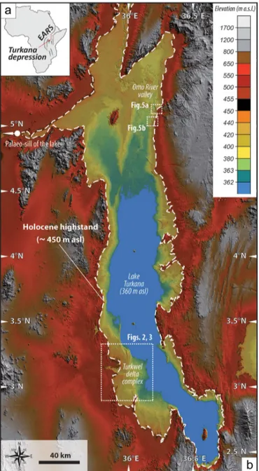
Figure 1. Location maps. (a) Lake Turkana basin in the East African Rift system (EARS). (b)Digital elevation model (DEM) SRTM1 showing Lake Turkana and the two investigated areas (Turkwel delta complex and the east side of the Omo River valley). Dashed white line represents the maximum Holocene lake level. All described geomorphological features are located between the palae-olake limit and the modern lake shoreline.
represent a valuable palaeohydrological archive that permits a greater understanding of Lake Turkana evolution during the AHP (Butzer, 1980; Owen et al., 1982; Garcin et al., 2012; Forman et al., 2014; Bloszies et al., 2015). However, the detailed and continuous evolution of lake level over the course of the last forced regression (i.e. basinward migration of the shoreline associated with a base level fall), marking the end of the AHP, has not been clearly documented. Here, the delta complex of the Turkwel River (Fig. 1), which
de-veloped during the last forced regression of Lake Turkana, is examined using trajectory analysis (Helland-Hansen and Hampson, 2009). We highlight variations in the rate of lake level fall during this ultimate regression. We then interpret these variations as markers that reflect changes in precipita-tion during the crucial period corresponding to the terminal phase of the AHP. Subsequently, we discuss potential forc-ings responsible for the regressive pattern of Lake Turkana with a primary focus on the role of the Sun and short-term variations in insolation.
2 Methods
The dataset is comprised of satellite imagery and a digital el-evation model (DEM). A recently obtained SRTM1 dataset (Shuttle Radar Topography Mission; Rabus et al., 2003) is available for the entire Lake Turkana area. This DEM is pro-duced by radar interferometry with 1 arcsec (approximately 30 m) horizontal grid spacing and provides a maximum 5 m absolute vertical error (Becek, 2008; Garcin et al., 2009). In addition, high-resolution (< 1 m) PLEIADES and (5 m) SPOT 5 images were used to focus on selected areas. This dataset was processed using GIS software (Global Mapper 15; www.globalmapper.com) to provide a high-resolution 3-D image of geomorphological features. Topographic profiles, elevation differences, and slope values were obtained using Global Mapper 15 software.
The trajectory analysis method is a recent development based on the principles of sequence stratigraphy. This ap-proach permits an estimate of the palaeoevolution of sea or lake levels based on the analysis of lateral and vertical migra-tion of shore-dependent landforms (i.e. shelf, coastal wedge, or deltaic systems). Four categories of shoreline trajectories exist: ascending regressive, descending regressive, transgres-sive, and stationary. These reflect normal regression, forced regression, transgression, and stable trends, respectively. In terms of base-level evolution, normal regression and trans-gression indicate a rise in sea or lake levels, while forced regression reflects a water level decline. Here, we apply this method to decipher the evolution of Lake Turkana levels at the end of the AHP.
3 Geomorphological analysis
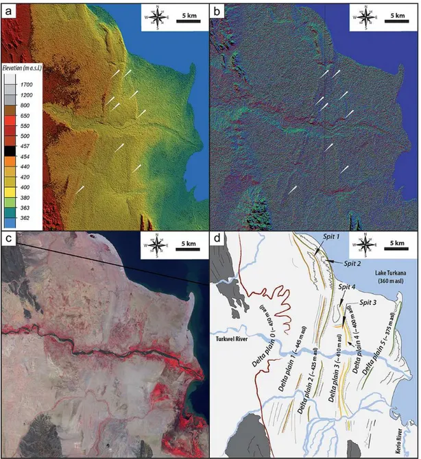
Figure 2.Turkwel delta complex. For location, see Fig. 1b.(a)Raw digital elevation model SRTM1 of the Turkwel delta.(b)Slope direc-tion shading applied to the DEM SRTM1 of the Turkwel delta to highlight the steps separating the different plateaus. Markers display the correspondence between(a)the DEM SRTM1 and(b)the slope direction shading.(c)SPOT5 satellite image of the Turkwel delta.(d) Inter-pretative geomorphological map of the area showing five successive delta plains in addition to the oldest plain associated with the late AHP highstand.
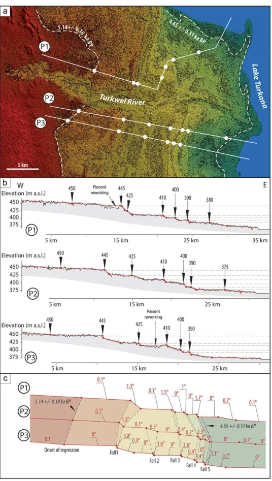
marks the last Holocene highstand before the end of the AHP. Moving eastward, each of the three topographic pro-files across the Turkwel delta complex (Fig. 3) show five slightly inclined plateaus separated by five abrupt 5 to 15 m high steps at ca. 445, 425, 410, 400, and 390 m a.s.l. (Fig. 4). Each plateau defines a different progradational stage. The plateaus are 3–5 km wide, and correspond to successively abandoned delta plains (Fig. 2d). To the north, these plateaus systematically end with palaeospits that document ancient, northward-flowing alongshore currents. The resulting land-form reveals the Turkwel delta complex to be composed of
tran-1612 A. Nutz and M. Schuster: Stepwise drying of Lake Turkana at the end of the AHP
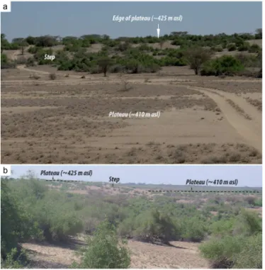
Figure 4.Landforms from the Turkwel delta.(a)Front view of a step grading downward to a plateau.(b)Side view of the same step separating two plateaus.
sects across the Turkwel delta complex along its progradation axes (Fig. 3), reveals that the plateaus are continuous, having slightly descending regressive trajectories (< 0.4◦). The five abrupt steps that separate plateaus have much higher slope gradients (1 to 3.8◦), and are also defined as descending re-gressive trajectories. The trajectories reflect a progradation associated with a general lake level fall that meets the defi-nition of a forced regression (Posamentier et al., 1992). The five abrupt steps reflect recurrent, short-lived increases in the rate of lake level fall that evidence a stepwise forced regres-sion at the end of the AHP.
In the eastern Omo River valley (Fig. 1), topographic pro-files along two fossil spits (Fig. 5) confirm this interpretation. Both spits show successive steps starting at elevations simi-lar to those observed in the Turkwel delta complex (ca. 445, 425, 410, and 400 m a.s.l.; Fig. 3). These additional observa-tions strongly support features in the Turkwel delta complex that reflect a stepwise forced regression of Lake Turkana at the end of the AHP.
4 Chronological framework
Humid conditions related to the AHP broadly prevailed over Africa from 14.8 to 5.5 ka cal BP (deMenocal et al., 2000; Shanahan et al., 2015). Several lake level curves developed from Lake Turkana provide records of the regional moisture history over the Holocene (Garcin et al., 2012; Forman et al., 2014; Bloszies et al., 2015). Based on surveys of raised
Holocene beach ridges coupled with dated archaeological sites, these studies also provide a relatively robust chrono-logical framework for its regression at the end of the AHP. Garcin et al. (2012) initially estimated the onset of the last lake level fall in Lake Turkana at ca. 5.27±0.36 ka cal BP
based on radiocarbon ages obtained from shells preserved in palaeoshorelines. Subsequently, using a similar method-ology, Forman et al. (2014) proposed that the age of this last regression occurred between 5.5/5.0 and 4.6 ka cal BP
associated to a lake level fall from 440 to 380 m a.s.l. Fi-nally, Bloszies et al. (2015) proposed an onset of the last re-gression of the AHP starting at 5.18±0.12 ka cal BP (shells
at 90 m above the modern Lake Turkana; sample SNU12-589) and finishing at 4.58±0.25 ka BP (optically stimulated
luminescence (OSL) age reused from Forman et al., 2014; sample UIC2319) associated with a lake level fall from 450 to 375 m a.s.l. Based on these published data, we carried out minor complementary processing in order to refine the chronology. First, we recalibrated sample SNU12-589, con-sidered to provide the age of the onset of the last regression. Using INTCAL13 (Reimer et al., 2013), the onset of the last regression is now 5.14±0.18 ka cal BP (4.51±0.06 ka
14C BP). Second, we converted the OSL age, represent-ing the end of the last regression of 4.58±0.5 ka BP (2σ )
by Forman et al. (2014), to radiocarbon years. Forman et al. (2014) provide six samples that were dated by both OSL and radiocarbon methods. Despite the limited number of samples, we ran a linear regression to propose a statisti-cal relationship between OSL and radiocarbon ages. Based on this correlation (age(OSL)=0.98386063×age(14C(calibrated));
b (the intercept) has been forced to 0; r2=0.9942), the
age of the end of the last regression is now estimated at 4.65±0.51 ka cal BP (4.14±0.17 ka14C BP). As the
in-vestigated portion of the Turkwel delta complex is lo-cated between 450 and 375 m a.s.l., the landforms are considered to have developed between 5.14±0.18 and
4.65±0.51 ka cal BP.
Based on this time interval, the last regression of Lake Turkana would, at the longest, span a period from 5.32 to 4.14 ka cal BP. Converting this longest potential time inter-val as radiocarbon ages (i.e. the interinter-val between 4.57 and 3.97 ka14C BP), a mean age of 4.27±0.3 ka14C BP is
estab-lished to thereby allow calibration and provide a probability curve. The probability curve reveals a ca. 43/44 %
probabil-ity that the last regression occurred precisely between 5.14 and 4.65 ka cal BP.
5 Discussion
1614 A. Nutz and M. Schuster: Stepwise drying of Lake Turkana at the end of the AHP
Figure 5.Fossil spits along the eastern Omo River valley (for location see Figure1b) from SRTM 1 (left panel) and from PLEIADES images (right panel). The fossil spits are outlined by dashed white lines. They display plateaus interrupted at similar elevations to those of the Turkwel delta.
in basin physiography. These changes may originate from a number of potential external forcing processes, among which the most commonly considered are tectonism and climate. Given the short timescale considered in this study, abrupt falls in lake level cannot be attributed to tectonism and any associated physiographic modification of the Lake Turkana basin. Vertical crustal movements occur over much longer
Figure 6.The red curve presents total solar irradiance (40-year moving average) relative to the value of the PMOD composite during the solar cycle minimum of the year 1986 (1365.57 W m−2; Steinhilber et al., 2009) for the period contemporaneous with AHP regression of Lake Turkana. The shaded band (yellow) represents 1σuncertainty. The blue curve represents the precessional curve covering the same time
period (http://www.imcce.fr/Equipes/ASD/insola/earth/online/). Grey stripes highlight solar activity minima.
systems. Finally, volcanic activity is known to have occurred during the Late Quaternary (Karson and Curtis, 1994), but its timing is not well constrained. Repeated pulses of accel-erated subsidence related to successive emptying of a magma chamber are also inconsistent with the limited amount of magma observed in the basin. Indeed, there is no regional magmatic effusion observed that would have caused sudden subsidence. Rather, magmatism corresponded to episodic, spatially limited effusions that formed the north, central, and south islands. As such, it is difficult to attribute the abrupt na-ture of the accelerated lake level falls to tectonism and mag-matism, thus rendering climate variability as the most likely forcing mechanism.
During the Holocene, the overall climate pattern in East Africa was governed by insolation patterns related to changes in precessional orbital parameters of the Earth (Barker et al., 2004). Links between insolation and hydrology are now well established for this region, with monsoonal rainfall in-tensity being strongly correlated with summer insolation. In the early Holocene, an increase in summer insolation pro-duced wetter conditions over much of the African continent leading to the establishment of the AHP and an expansion of lakes (deMenocal et al., 2000; Shanahan et al., 2015). Subsequently, the overall contraction of lakes at the end of the AHP is generally attributed to decreased precipitation related to an orbitally controlled reduction in summer in-solation (deMenocal et al., 2000; deMenocal and Tierney, 2012; Bard, 2013; Shanahan et al., 2015) Insolation changes drive modifications in rainfall amounts through the strength-ening or weakstrength-ening of local climate processes. In the Lake Turkana area, Junginger et al. (2014) suggest that the in-crease in precipitation during the AHP is mainly a result of a north-eastward shift of the Congo Air Boundary (CAB). The CAB is a north-east–south-west-oriented convergence zone
presently located west of the Lake Turkana area. This conver-gence zone shifts eastward in response to an enhanced atmo-spheric pressure gradient between India and East Africa dur-ing Northern Hemisphere insolation maxima (Jungdur-inger and Trauth, 2013; Junginger et al., 2014). When the CAB moves eastward over the Turkana area, precipitation is expected to increase significantly. As the five abrupt accelerations in lake level fall require short-term accentuated decreases in precip-itation, we propose that these five periods of significantly re-duced rainfall amounts are related to short-term decreases in insolation that repeatedly displaced the CAB. In our opinion, at such decadal to centennial timescales, variations in solar activity appear as the most likely parameter to explain varia-tions in insolation.
5.2 Linking solar activity and palaeohydrology
Establishing links between short-term (decadal-scale) solar activity and climate change remains a point of debate. Peri-odicities in solar activity, such as the 11-year sunspot cycle, the Gleissberg cycle (80–90 years; Peristykh and Damon, 2003) or the de Vries cycle (∼200 years; Raspopov et al.,
1616 A. Nutz and M. Schuster: Stepwise drying of Lake Turkana at the end of the AHP
due to their specific morphology. As an amplifier lake, Lake Turkana should be sensitive to variations in precipitation in-duced by small variations in insolation.
When we compare the proposed chronological framework with the solar activity curve from Steinhilber et al. (2009), we observe between one and fourteen solar activity minima during the minimum and maximum potential periods of re-gression, respectively (Fig. 6). During the time period consis-tent with the average duration of the regression – 490 years between 5.14 and 4.65 ka cal BP – five solar activity min-ima are observed. Given that the number of these minmin-ima matches the number of abrupt lake level falls, this may sug-gest a causal link between the short-term variability of solar activity and the lake level changes in Lake Turkana at the end of the AHP. Even though robust chronological correla-tions are not yet available between these short-term acceler-ations of lake level fall and solar activity minima, we pro-pose a mechanism linking solar activity and lake level evolu-tion. We suggest that periods of solar activity maxima would be able to compensate for the precession-induced reduction of insolation. The relatively limited reduction of insolation would have led to a relatively stable position for the CAB over the Lake Turkana area. As such, this would favour a re-duced rate of lake level fall due to slowly decreasing rates of precipitation amounts. However, when short-term solar ac-tivity minima are coupled with the precession-related insola-tion decrease, the CAB would have migrated rapidly west-ward, resulting in a drastic reduction of rainfall and, as a consequence, producing a rapid fall in lake level. As such, alternations of solar activity maxima and minima could ex-plain the geomorphological evidence for a long-term forced regression interspersed by short-term accelerations in the rate of lake level fall at the end of the AHP.
6 Conclusions
Geomorphic analysis (i.e. trajectory analysis) of the Turkwel delta complex reveals, for the first time, a stepwise lake level fall of Lake Turkana during its last forced regression at the end of the African Humid Period. Five rapid falls in lake level were identified, intercalated with periods of slower lake level fall. These five rapid falls in lake level reflect five short-term periods associated with drastic decreases in precipitation. We propose that these abrupt, short-term decreases in precipita-tion are associated with insolaprecipita-tion minima altering the po-sition of the Congo Air Boundary, the large-scale circula-tion system responsible for regional precipitacircula-tion patterns over this region. Furthermore, we propose that the short-term changes in insolation are caused by variations in solar activ-ity. The next research step would be to precisely date each plateau and each step to a specific solar maximum and mini-mum, respectively. Nevertheless, existing dating methods do not, however, provide precise enough ages at such decadal to centennial timescales.
7 Data availability
SRTM digital elevation model is free to access using the web-site: earthexplorer.usgs.gov. PLEIADES and SPOT images were bought thanks to the support of the CNES and are not freely available.
Acknowledgements. This work is a contribution of the Rift Lake Sedimentology project (RiLakS) funded by Total Oil Company. Satellite images (SPOT and PLEIADES) were acquired thanks to the support of the CNES/ISIS program. Finally, we are grateful to Murray Hay (Maxafeau Editing Services) for verifying the English within the text.
Edited by: A. Stroeven
Reviewed by: two anonymous referees
References
Anthony, E. J.: Wave influence in the construction, shaping and de-struction of river deltas: A review, Mar. Geol. 361, 53–78, 2015. Bard, E.: Out of the African Humid Period, Science, 342, 808–809,
2013.
Barker, P. A., Talbot, M. R., Street-Perrott, F. A., Marret, F., Scourse, J., and Odada, E. O.: Late Quaternary climatic vari-ability in intertropical Africa, in: Past climate varivari-ability through Europe and Africa, edited by: Battarbee, R. W., Gasse, F., and Strickley, C. E., Springer, Dordrecht, 2004.
Becek, K.: Investigating error structure of shuttle radar topography mission elevation data product, Geophys. Res. Lett. 35, L15403, doi:10.1029/2008GL034592, 2008.
Bhattacharya, J. P. and Giosan, L.: Wave-influenced deltas: geo-morphological implications for facies reconstruction, Sedimen-tology, 50, 187–210, 2003.
Bloszies, C., Forman, S. L., and Wright, D. K.: Water level history for Lake Turkana, Kenya in the past 15 000 years and a variable transition from the African Humid Period to Holocene aridity, Global Planet. Change, 132, 64–76, 2015.
Bond, G., Kromer, B., Beer, J., Muscheler, R., Evans, M. N., Show-ers, W., Hoffman, S., Lotti-Bond, R., Hajdas, I., and Bonani, G.: A pervasive millennial-scale cycle in North Atlantic Holocene and glacial climates, Science, 278, 1257–1266, 2001.
Butzer, K. W.: The Holocene lake plain of Lake Rudolph, Phys. Geogr., 1, 42–58, 1980.
Crowley, T.: Causes of climate change over the past 1000 years, Science, 289, 270–277, 2000.
deMenocal, P. B. and Tierney, J. E.: Green Sahara: African Humid Periods paced by Earth’s orbital changes, Nature Educ. Knowl., 3, 12, 2012.
deMenocal, P. B., Ortiz, J., Guilderson, T., Adkins, J., Sarnthein, M., Baker, L., and Yarusinsky, M.: Abrupt onset and termination of the African Humid Period: rapid climate responses to gradual insolation forcing, Quaternary Sci. Rev., 19, 347–361, 2000. Forman, S. L., Wright, D. K., and Bloszies, C.: Variations in
Garcin, Y., Junginger, A., Melnick, D., Olago, D. O., Strecker, M. R., and Trauth, M. H.: Late Pleistocene rise and collapse of Lake Suguta, northern Kenya Rift, Quaternary Sci. Rev., 28, 911–925, 2009.
Garcin, Y., Melnick, D., Strecker, M. R., Olago, D., and Tiercelin, J.-J.: East African mid-Holocene wet-dry transition recorded in palaeo-shorelines of Lake Turkana, northern Kenya Rift, Earth Planet. Sc. Lett., 331–332, 322–334, 2012.
Gray, L., Scaife, A. A., Mitchell, D. M., Osprey, S., Ineson, S., Hardiman, S., Butchart, N., Knight, R., Sutton, R., and Kodera, K.: A lagged response to the 11-year solar cycle in observed win-ter Atlantic/European weather patwin-terns, J. Geophys. Res., 118, 13405–13420, 2013.
Halfman, J. D., Johnson, T. C., and Finney, B. P.: AMS dates, strati-graphic correlations and decadal climatic cycles for the past 4 ka at Lake Turkana, Kenya, Palaeogeogr. Palaeocl., 111, 83–98, 1994.
Helland-Hansen, W. and Hampson, G.: Trajectory analysis: con-cepts and application, Basin Res., 21, 454–483, 2009.
Junginger, A. and Trauth, M. H.: Hydrological constraints of paleo-Lake Suguta in the Northern Kenya Rift during the African Hu-mid Period (12–5 ka BP), Global Planet. Change, 111, 174–188, 2013.
Junginger, A., Roller, S., Olaka, L. A., and Trauth, M. H.: The ef-fects of solar irradiation changes on the migration of the Congo Air Boundary and water levels of paleo-Lake Suguta, North-ern Kenya Rift, during the African Humid Period (15–5 ka BP), Palaeogeogr. Palaeocl., 396, 1–16, 2014.
Karson, J. A. and Curtis, P. C.: Quaternary volcanic centres of the Turkana Rift, Kenya, J. Afr. Earth Sci., 18, 15–35, 1994. Kröpelin, S., Verschuren, D., Lézine, A.-M., Eggermont, H.,
Coc-quyt, C., Francus, P., Cazet, J.-P., Fagot, M., Rumes, B., Russell, J. M., Darius, F., Conley, D. J., Schuster, M., von Suchodoletz, H., and Engstrom, D. R.: Climate-driven ecosystem succession in the Sahara: The past 6000 years, Science, 320, 765–768, 2008. Kutzbach, J. E. and Street-Perrott, F. A.: Milankovitch forcing of
fluctuations in the level of tropical lakes from 18 to 0 kyr BP, Na-ture, 317, 130–134, 1985.
Kuper, R. and Kröpelin, S.: Climate-controlled Holocene occupa-tion in the Sahara: Motor of Africa’s evoluoccupa-tion, Science, 313, 803–807, 2006.
Liu, Z., Wang, Y., Gallimore, R., Gasse, F., Johnson, T., deMenocal, P., Adkins, J., Notaro, M., Prentice, I. C., Kutzbach, J., Jacob, R., Behling, P., Wang, L., and Ong, E.: Simulating the transient evo-lution and abrupt change of Northern Africa atmosphere-ocean-terrestrial ecosystem in the Holocene, Quaternary Sci. Rev., 26, 1818–1837, 2007.
Morley, C. K., Karanja, F. M., Wescott, W. A., Stone, D. M., Harper, R. M., Wigger, S. T., and Day, R. A.: Geology and geophysics of the western Turkana basins, Kenya, Am. Assoc. Petrol. Geol., 44, 19–54, 1999.
Morrissey, A. and Scholz, C. A.: Paleohydrology of Lake Turkana and its influence on the Nile River system, Palaeogeogr. Palaeocl., 403, 88–100, 2014.
Nutz, A., Schuster, M., Ghienne, J.-F., Roquin, C., and Bouchette, F.: Wind-driven waterbodies: A new category of lake within an alternative sedimentologically-based lake classification, J. Pale-olimnol., doi:10.1007/s10933-016-9894-2, 2016.
Owen, R. B., Barthelme, J. W., Renaut, R. W., and Vincens, A.: Paleolimnology and archaeology of Holocene deposits north-east of Lake Turkana, Kenya, Nature, 298, 523–529, 1982.
Patricola, C. M. and Hook, K. H.: Sub-Saharan Northern African climate at the end of the twenty-first century: Forcing factors and climate change processes, Clim. Dynam., 37, 1165–1188, 2011. Pavlides, S. and Caputo, R.: Magnitude versus faults’ surface pa-rameters: quantitative relationships from the Aegean Region, Tectonophysics, 380, 159–188, 2004.
Peristykh, A. N. and Damon P. E.: Persistence of the Gleiss-berg 88-year solar cycle over the last 12 000 years: Evi-dence from cosmogenic isotopes, J. Geophys. Res., 108, 1003, doi:10.1029/2002JA009390, 2003.
Posamentier, H. W., Allen, G. P., James, D. P., and Tesson, M.: Forced regressions in a sequence stratigraphic framework: con-cepts, examples, and exploration significance, Am. Assoc. Petrol. Geol. Bull., 76, 1687–1709, 1992.
Rabus, B., Eineder, M., Roth, A., and Bamler, A.: The shuttle radar topography mission – a new class of digital elevation models ac-quired by spaceborne radar, ISPRS J. Photogram. Remote Sens., 57, 241–262, 2003.
Raspopov O. M., Dergachev, V. A., Esper, J., Kozyreva, O. V., Frank, D., Ogurtsov, M., Kolström, T., and Shao, X.: The influ-ence of the de Vries (200-years) solar cycle on climate variations: Results from the Central Asian Mountains and their global link, Palaeogeogr. Palaeocl., 259, 6–16, 2008.
Reimer, P. J., Bard, E., Bayliss, A., Beck, J. W., Blackwell, P. G., Bronk Ramsey, C., Buck, C. E., Cheng, H., Edwards, R. L., Friedrich, M., Grootes, P. M., Guilderson, T. P., Haflidason, H., Hajdas, I., Hatté, C., Heaton, T. J., Hoffmann, D. L., Hogg, A. G., Hughen, K. A., Kaiser, K. F., Kromer, B., Manning, S. W., Niu, M., Reimer, R. W., Richards, D. A., Scott, E. M., Southon, J. R., Staff, R. A., and Turney, C. S. M., INTCAL13 and MARINE13 radiocarbon age calibration curves, 0–50 000 years Cal BP, Ra-diocarbon, 55, 1869–1887, 2013.
Renssen, H., Brovkin, V., Fichefet, T., and Goosse, H.: Simulation of the Holocene climate evolution in Northern Africa: The termi-nation of the African Humid Period, Quatern. Int., 150, 95–102, 2006.
Shanahan, T. M., McKay, N. P., Hughen, K. A., Overpeck, J. T., Otto-Bliesner, B., Heil, C. W., King, J., Scholz, C. A., and Peck, J.: The time-transgressive termination of the African Humid Pe-riod, Nat. Geosci., 8, 140–144, 2015.
Stager, J. C., Mayewski, P. A., and Meeker, L. D.: Cooling cycles, Heinrich event 1, and the desiccation of Lake Victoria, Palaeo-geogr. Palaeocl., 183, 169–178, 2002.
Steinhilber, F., Beer, J., and Fröhlich, C.: Total solar irradi-ance during the Holocene, Geophys. Res. Lett., 36, L19704, doi:10.1029/2009GL040142, 2009.
Street, F. A.: The relative importance of climate and local hydro-geological factors in influencing lake-level fluctuations, Palaeoe-cology of Africa, 12, 83–118, 1980.
Street, F. A. and Grove, A. T.: Environmental and climatic implica-tions of late Quaternary lake level fluctuaimplica-tions in Africa, Nature, 261, 385–390, 1976.
1618 A. Nutz and M. Schuster: Stepwise drying of Lake Turkana at the end of the AHP
F. A., Beran, M., and Ratcliffe, R.A . S., Dordrecht, Reidel, 331– 345, 1983.
Tierney, J. E. and deMenocal, P.: Abrupt shifts in Horn of Africa hy-droclimate since the Last Glacial Maximum, Science, 342, 843– 846, 2013.
Tierney, J. E., Lewis, S. C., Cook, B. I., LeGrande, A. N., and Schmidt, G. A.: Model, proxy and isotopic perspectives on the East African Humid Period, Earth Planet. Sc. Lett., 307, 103– 112, 2011.