HESSD
12, 10157–10195, 2015Impacts of climate change under CMIP5 RCP scenarios on the
streamflow in the Dinder River
A. K. Basheer et al.
Title Page
Abstract Introduction
Conclusions References
Tables Figures
◭ ◮
◭ ◮
Back Close
Full Screen / Esc
Printer-friendly Version
Interactive Discussion
Discussion
P
a
per
|
Discussion
P
a
per
|
Discussion
P
a
per
|
Discussion
P
a
per
Hydrol. Earth Syst. Sci. Discuss., 12, 10157–10195, 2015 www.hydrol-earth-syst-sci-discuss.net/12/10157/2015/ doi:10.5194/hessd-12-10157-2015
© Author(s) 2015. CC Attribution 3.0 License.
This discussion paper is/has been under review for the journal Hydrology and Earth System Sciences (HESS). Please refer to the corresponding final paper in HESS if available.
Impacts of climate change under CMIP5
RCP scenarios on the streamflow in the
Dinder River and ecosystem habitats in
Dinder National Park, Sudan
A. K. Basheer1,2, H. Lu1, A. Omer1, A. B. Ali3, and A. M. S. Abdelgader4
1
State Key Laboratory of Hydrology-Water Resources and Hydraulic Engineering, College of Hydrology and Water Resources, Hohai University, Nanjing, 210098, China
2
Ministry of Agriculture and Irrigation, River Nile State, P.O. Box 8168, Adamar, 12217, Sudan
3
College of Water Conservancy and Hydropower, Hohai University, Nanjing, 210098, China
4
School of information science and Eng. Southeast University, Nanjing, 210096, China
Received: 19 September 2015 – Accepted: 21 September 2015 – Published: 8 October 2015
Correspondence to: H. Lu ([email protected])
HESSD
12, 10157–10195, 2015Impacts of climate change under CMIP5 RCP scenarios on the
streamflow in the Dinder River
A. K. Basheer et al.
Title Page
Abstract Introduction
Conclusions References
Tables Figures
◭ ◮
◭ ◮
Back Close
Full Screen / Esc
Printer-friendly Version
Interactive Discussion
Discussion
P
a
per
|
Discussion
P
a
per
|
Discussion
P
a
per
|
Discussion
P
a
per
|
Abstract
The fate of seasonal rivers ecosystem habitats under climate change essentially de-pends on the changes in annual recharge, which related to alterations in precipitation and evaporation over the river basin. Therefore the change in climate conditions is expected to significantly affect hydrological and ecological components, particularly in
5
fragmented ecosystems. This study aims to assess the impacts of climate change on the streamflow in Dinder River Basin (DRB), and infer its relative possible effects on the Dinder National Park (DNP) ecosystem habitats in the Sudan. Two global circu-lation models (GCMs) from Coupled Model Intercomparison Project Phase 5 and two statistical downscaling approaches combined with hydrological model (SWAT) were
10
used to project the climate change conditions over the study periods 2020s, 2050s and 2080s. The results indicated that the climate over the DRB will become warmer and wetter under the most scenarios. The projected precipitation variability mainly depends on the selected GCM and downscaling approach. Moreover, the projected streamflow was more sensitive to rainfall and temperature variation, and will likely increase in this
15
century. In contrast to drought periods during (1960s, 1970s and 1980s), the predicted climate change is likely to affect ecosystems in DNP positively and promote the eco-logical restoration of the flora and fauna habitats’.
1 Introduction
The climate change over the next century expected to severely impact water resources;
20
arid and semi-arid areas are particularly more vulnerable to that change and projected to suffer from water shortage due to precipitation reduction (Tavakoli and De Smedt, 2011; Setegn et al., 2011). Alteration in hydrologic conditions will affect almost every aspect of natural resources and human well-being (Xu, 1999). For instance, ecosys-tem integrity is influenced either directly or indirectly by climate change and hydrologic
25
HESSD
12, 10157–10195, 2015Impacts of climate change under CMIP5 RCP scenarios on the
streamflow in the Dinder River
A. K. Basheer et al.
Title Page
Abstract Introduction
Conclusions References
Tables Figures
◭ ◮
◭ ◮
Back Close
Full Screen / Esc
Printer-friendly Version
Interactive Discussion
Discussion
P
a
per
|
Discussion
P
a
per
|
Discussion
P
a
per
|
Discussion
P
a
per
to alterations in the hydrological process usually include complex interactions of biotic and abiotic processes. Hence, the hydrological variability can highly impact the ecosys-tem species in a variety of ways, such as the linkage between water availability and metabolic and reproductive processes of that species (Burkett et al., 2005). Among all ecosystems, freshwater ecosystem is seriously expected to affect species, which
5
mainly caused by climate change (Millennium Ecosystem Assessment, 2005). Both current climate (maximum temperature) and climate change (precipitation change) ap-pear to be key determinants of habitat loss and fragmentation effects on terrestrial biodiversity (Mantyka-pringle et al., 2012). In some part of the world, ecosystems are already being affected by climate variability. Furthermore, it is very likely that the
mag-10
nitude and frequency of ecosystem changes will possible rapidly increase and continue in the future (Thomas et al., 2004). As the climate conditions have changed in both pre-cipitation and temperature trends over recent decades, the timing of these events has become vulnerable for alteration as well. According to the Gitay et al. (2002) projec-tions, the ecosystem components in the Northern Hemisphere will experience serious
15
alterations in terms of earlier flowering of plants, migration of birds, animal breeding seasons and emergence of insects. Consequently, under the smallest climatic change scenarios, 18 % of species were found to be “committed to extinction” while the largest change scenario projected as many as 35 % of species to be at risk (Thomas et al., 2004). Many studies investigated the impact of the streamflow change on the
fresh-20
water ecosystems, which will probably have strong effects on the system components and abiotic characteristic (Poffand Ward, 1989; Poffand Zimmerman, 2010; Döll and Zhang, 2010; Mantyka-pringle et al., 2012). Erwin (2009) concluded that the wetlands will a strongly be influenced due to climate alteration and to overcome all these impact firstly assessment of the affect should be conducted. These assessments should be
25
HESSD
12, 10157–10195, 2015Impacts of climate change under CMIP5 RCP scenarios on the
streamflow in the Dinder River
A. K. Basheer et al.
Title Page
Abstract Introduction
Conclusions References
Tables Figures
◭ ◮
◭ ◮
Back Close
Full Screen / Esc
Printer-friendly Version
Interactive Discussion
Discussion
P
a
per
|
Discussion
P
a
per
|
Discussion
P
a
per
|
Discussion
P
a
per
|
of the DNP (Abdel Hameed et al., 1997). Seasonality of DR makes it more sensitive to climate change effects, because it mainly depends on seasonal rainfall, which ex-pected to be altered in timing and magnitude. On the other hand, ecosystem habitats in the Dinder river basin (DRB) is basically controlled by the river runoffand climate variables such as temperature and precipitation. Whereas, DNP biodiversity is related
5
to high flow events of DR that influence the river channel shape and allow access to other disconnect floodplain habitats, and to low flow events that limit overall habitats availability and quality. Ecosystem in DNP contains a group of islands, and wetlands (Mayas) consist of a diverse array of fauna and flora and represent adequate environ-ment for most nutritious grasses to the herbivores, especially during the most severe
10
part of the dry season. Thus, relative changes in hydrological process and climate vari-ables over DRB directly affect the ecosystem habitats and components in the DNP as general.
In order to evaluate the effects of climate change on natural resources, technical measurements and researches should be conducted within the context of water
re-15
sources management and maintaining ecosystem integrity at the local and territorial scales. One of the best tools for simulating current and future prediction of climate change scenarios is GCMs (Xu, 1999). However, there is a general consensus among the scientific community that GCM outputs cannot be used directly as input to hydrolog-ical models, which often operate on spatial scales smaller than those of GCMs (Wilby
20
et al., 2002). To predict changes in hydrology and water resources, downscaling the outputs of the GCM on the global scale into the inputs of the hydrological model on the regional scale has been widely applied to obtain the hydrological response (Charlton et al., 2006; Steele-Dunne et al., 2008). Statistical downscaling is thus often used to bridge the scale gap in linking GCM outputs with hydrological models because it does
25
HESSD
12, 10157–10195, 2015Impacts of climate change under CMIP5 RCP scenarios on the
streamflow in the Dinder River
A. K. Basheer et al.
Title Page
Abstract Introduction
Conclusions References
Tables Figures
◭ ◮
◭ ◮
Back Close
Full Screen / Esc
Printer-friendly Version
Interactive Discussion
Discussion
P
a
per
|
Discussion
P
a
per
|
Discussion
P
a
per
|
Discussion
P
a
per
the climate change effect for simulation. The Soil and Water Assessment Tool (SWAT) is one of the widely used model which has the capability of incorporating the climate change effect for simulation (Ficklin et al., 2010).
Up to the authors’ knowledge, the impact of climate change in DRB has not been thoroughly projected and explicitly explored by which of these hydrological alteration,
5
the DNP wetland habitats can be affected. Investigation of the ecosystem habitats re-sponse to climate change is hard to achieve at a sufficient scale. However, the climatic impact and hydrological alteration could potentially have large effect on ecosystem habitats need to be considered.
The objectives of this paper are: (1) assess the climate change effect on the future
10
streamflow magnitude of the DRB, using SWAT coupled with two GCMs under various climate change scenarios and two downscaling approaches, (2) investigation of the potential impacts of climate change on the DNP ecosystem components, in order to provide benchmarked information for the decision-makers to be included in adaptation strategies for water resources and environment sustainable development. The rest of
15
the paper is organized as follows. Section 2 describes the study area including climate, hydrology and DNP ecosystem components. This is followed by a brief description of the SWAT model and two downscaling approaches used to downscale the GCMs model outputs. Section 4 provides the results and discussion of the projected climate variables and streamflow when applying two methods and investigates their affect on
20
the ecosystem habitats. Section 6 concludes this works.
2 Materials and methods
2.1 Study area
Dinder River Basin (DRB) is the largest tributary of the Blue Nile in Sudan. It has a seasonal character where it starts surging in June, peaking around the middle of
25
HESSD
12, 10157–10195, 2015Impacts of climate change under CMIP5 RCP scenarios on the
streamflow in the Dinder River
A. K. Basheer et al.
Title Page
Abstract Introduction
Conclusions References
Tables Figures
◭ ◮
◭ ◮
Back Close
Full Screen / Esc
Printer-friendly Version
Interactive Discussion
Discussion
P
a
per
|
Discussion
P
a
per
|
Discussion
P
a
per
|
Discussion
P
a
per
|
basin ranges in elevation from 2646 m at an Ethiopian plateau to 515 m at the north-west point where it joined the Blue Nile and its catchments’ area about 31 422 km2. DRB geographic coordination is 11◦41′ to 13◦85′N and 34 to 36◦20′E. The average annual discharge for the previous 40 years at the Al Gwisi hydrological station is about 1.9 billion m3(BCM), with seasonal variation ranged between 151 % (4.78 BCM)
incre-5
ment in the wettest year and 65 % (0.35 BCM) decrease in the dry year. This high vari-ability of the runoffis due to the significant rainfall alteration over the basin. The main land use and land cover classes in DRB are agriculture, forest, grass, bush, shrubs and others (Abdel Hameed, 1983; Abdel Hameed and Eljack, 2003). Land use of the study area has changed over time due to over increasing population density and agricultural
10
practices. The clay plains of DRB are probably the most striking feature of the geo-morphology of Sudan (Whiteman, 1971). There are some types of soil in DRB such as Eutric Cambisols, Chromic Cambisols, Eutric Gleysols, Eutric Regosols,Chromic VertisolsandPellic Vertisols. The sandy river bed is left with only a few pools (Mayas) which may hold water up to the next rainy season after it ceases to flow (Abdel Hameed,
15
1983). The annual rainfall amount is normally increased gradually from 500 mm in the north-western part to 1110 mm in the south-eastern part. The DRB drainage system contains of four sub-drainages namely Khor Galegu drainage system, which is the biggest tributary of the Dinder River, Khor Masaweek, East bank of river Dinder and West bank of river Dinder. Each one of these sub-drainages consists of a number of
20
Mayas, which mainly fed by the main DR stream and its tributaries through distinct feeder channels according to the amount of overflow of the river in flood months (Abdel Hameed et al., 1997).
2.2 Dinder national park ecosystem
Dinder national park is considered one of the largest natural reserves in northeast
25
HESSD
12, 10157–10195, 2015Impacts of climate change under CMIP5 RCP scenarios on the
streamflow in the Dinder River
A. K. Basheer et al.
Title Page
Abstract Introduction
Conclusions References
Tables Figures
◭ ◮
◭ ◮
Back Close
Full Screen / Esc
Printer-friendly Version
Interactive Discussion
Discussion
P
a
per
|
Discussion
P
a
per
|
Discussion
P
a
per
|
Discussion
P
a
per
and 13◦00′N, covering an area of 10 846 km2. DNP is the only national park north of the 10 parallel, which forms an important ecological zone in the arid and semi-arid Sudano-Saharan region. It has high elevation variation ranges from 2646 m at an Ethiopian Plateau to about 515 m at the south-eastern part and 100 m at north-eastern part. The Park has unique biodiversity contain a variety with over 250 species of birds,
5
27 species of large mammals; some of them are listed by the International Union for Conservation of Nature (IUCN) as endangered, vulnerable or threatened species, in addition to an unknown number of smaller mammals. Therefore, the park is consid-ered as adequate habitation for a large number of animals during the dry season and a few numbers when it rains from June through October. The Mammalian fauna leave
10
the Mayas of the park during the rainy season to the high grounds at the east part, in Ethiopia and return with the onset of the dry season. The Mayas are formed by meanders and oxbows along the rivers. It provides dwelling and support for a large number of animal species, such as tiang (Damaliscus korrigum), lion (Panthera leo), Elephant (Loxodonta africana, leopard (Panthera pardus), wild dog (Lycaon pictus), the
15
red–fronted gazell (Gazella rufifrons), greater kudu (Tragelaphus strepsicerus), Nubian giraffe (Giraffa camelopardalis), black-backed jackal (Conis mesomelas), Arabian bus-tard and greater busbus-tard. There are also numerous hides of insects, which serve a vital function in recycling of the organic compounds (Abdel Hameed and Eljack, 2003).
2.3 The hydrological model (SWAT)
20
SWAT is a continuous, long-term, distributed-parameter hydrological model designed to predict the impact of land management practices on the hydrology and sediment and contaminant transport in agricultural watersheds (Arnold et al., 1998). SWAT sub-divides a watershed into sub-basins connected by a stream network, and further de-lineates hydrologic response units (HRUs) consisting of unique combinations of land
25
HESSD
12, 10157–10195, 2015Impacts of climate change under CMIP5 RCP scenarios on the
streamflow in the Dinder River
A. K. Basheer et al.
Title Page
Abstract Introduction
Conclusions References
Tables Figures
◭ ◮
◭ ◮
Back Close
Full Screen / Esc
Printer-friendly Version
Interactive Discussion
Discussion
P
a
per
|
Discussion
P
a
per
|
Discussion
P
a
per
|
Discussion
P
a
per
|
delineation minimizes the computational costs of simulations by lumping similar soil and land use areas into a single unit (Neitsch et al., 2002). A detailed description of the basin scale of hydrological model (SWAT) can be found in many literature such as Neitsch et al. (2005a, b).
Input data preparation
5
In addition to meteorological data, the model simulation required a range of spatially distributed data such as topographic features, soil types, land use and the stream net-work (optional). Digital Elevation Model (90 m, USGS) (Fig. 1) was used to delineate the watershed and the drainage patterns of the surface area analysis. Daily meteo-rological data, such as temperature and precipitation were collected from Ministry of
10
Water resources and Electricity and Nile Basin Initiative for the period 1961 to 2008. These data are interpolated from meteorological stations distributed within the Blue Nile River Basin. Moreover, daily records of the river discharge at the Al Gwisi hydro-logical station were obtained from the Ministry of Water Resources and Electricity of Sudan. Land use map in this study was obtained from the land cover institute (LCI)
15
(http://landcover.usgs.gov/) and other field classification for the study area. The soil map for the study area extracted from the digital soil map of the world (FAO) and African soil map.
2.4 Global circulation model selection
The projected temperature and precipitation were obtained from the IPCC Data
Dis-20
tribution Centre (http://cmip-pcmdi.llnl.gov/cmip5/). Two GCMs have been selected in this study as shown in Table 1. The MPI-ESM-LR model which developed by the Max-Planck-Institute for Meteorology, Hamburg, Germany, and the CCSM4 model devel-oped by the National Centre for Atmospheric Research. Representative concentration pathway (RCP4.5 and RCP8.5) forcing climate scenarios were selected based on the
25
HESSD
12, 10157–10195, 2015Impacts of climate change under CMIP5 RCP scenarios on the
streamflow in the Dinder River
A. K. Basheer et al.
Title Page
Abstract Introduction
Conclusions References
Tables Figures
◭ ◮
◭ ◮
Back Close
Full Screen / Esc
Printer-friendly Version
Interactive Discussion
Discussion
P
a
per
|
Discussion
P
a
per
|
Discussion
P
a
per
|
Discussion
P
a
per
to 2095 were extracted from grid cells covering DRB. The period from 1961–1990 was defined as the baseline period (denoted by 1980s). While the future periods which cov-ered by this study are 2006–2035, 2036–2065 and 2066–2095 (denoted by the 2020s, 2050s and 2080s, respectively), except precipitation for CCSM4 model under RCP8.5 scenario (2066–2093).
5
3 Methodology
3.1 Streamflow simulation and calibration
SWAT was used to simulate streamflow in DRB. SWAT provides two methods for esti-mating surface runoff; the SCS curve number and the Green-Ampt infiltration method. The model calculates the peak runoffrate with a modified rational method (Chow et al.,
10
1988). An automated calibration technique with Sequential Uncertainty Fitting Version 2 (Abbaspour et al., 2007) was used to calibrate the simulated streamflow at the Al-gwisi station in the DRB. Sensitive initial and default parameters related to hydrology were changed concurrently until an optimal solution was met. The coefficient of deter-mination (R2), and the Nash–Sutcliffe coefficient (Nash and Sutcliffe, 1970) were used
15
to assess the model performance.
3.2 Statistical downscaling of temperature and rainfall time series
The GCMs outputs resolution is too coarse for regional impact assessment study; therefore, downscaling must be performed before applying GCM outputs into the SWAT model (Dessu and Melesse, 2013). Both change factor (CF) and quantile mapping
20
HESSD
12, 10157–10195, 2015Impacts of climate change under CMIP5 RCP scenarios on the
streamflow in the Dinder River
A. K. Basheer et al.
Title Page
Abstract Introduction
Conclusions References
Tables Figures
◭ ◮
◭ ◮
Back Close
Full Screen / Esc
Printer-friendly Version
Interactive Discussion
Discussion
P
a
per
|
Discussion
P
a
per
|
Discussion
P
a
per
|
Discussion
P
a
per
|
3.2.1 Change factor downscaling method (CF)
In general, the CF method (Hay et al., 2000; Diaz-Nieto and Wilby, 2005) is an ordinary bias correction method. The CF method is often used to exclude or minimize the bias between observations and the model outputs. The CF procedures rely on modifying the daily time step series of the climate variables such as precipitation and temperature for
5
prediction periods (2020s, 2050s and 2080s) by adding the monthly mean changes of GCM outputs. The adjusted formulas which are used to modify daily temperature and precipitation are expressed in Eqs. (1) and (2).
Tadj; fur; d=Tobs; d+
Xk
i=1pi
TGCM; fur; m−TGCM; ref; m
(1)
Padj; fur; d=Pobs; d×
Xk
i=1pi
PGCM; fur; m/PGCM; ref; m
(2)
10
whereTadj; fur; d is the adjusted daily temperature (Tmax and Tmin) for the future years,
Tobs; dis the observed daily temperature for the baseline years,TGCM; fur; mis the monthly
mean temperature of the GCM outputs for the future years,TGCM; ref; m is the monthly
mean temperature of the GCM outputs for the baseline years,piis the weight of each grid cell andk is the number of the grid cells.
15
3.2.2 Quantile mapping downscaling method (QM)
Quantile mapping is an emerging downscaling approach that utilized to remove bias of observed and simulated rainfall using cumulative distribution functions (CDF). QM basically replaces the simulated (GCMs) rainfall value with the observed value that has the same non-exceedance probability. It shifts the occurrence distributions of
precipi-20
HESSD
12, 10157–10195, 2015Impacts of climate change under CMIP5 RCP scenarios on the
streamflow in the Dinder River
A. K. Basheer et al.
Title Page
Abstract Introduction
Conclusions References
Tables Figures
◭ ◮
◭ ◮
Back Close
Full Screen / Esc
Printer-friendly Version
Interactive Discussion
Discussion
P
a
per
|
Discussion
P
a
per
|
Discussion
P
a
per
|
Discussion
P
a
per
f γ x/α,β
=xα−1· 1 βα·Γ(α)·e
−x
β ; x≥0; α,β >0 (3)
whereα is Shape parameter of Gamma distribution, βis Scale parameter of Gamma distribution,f is Distribution function,eis Euler’s number,Γis Gamma function andx is Independent (random) variable.
In this study, we used an advanced version of QM approach developed recently by
5
Willems et al. (2012). The CDFs were set up on a daily basis for observed and the GCM-simulated rainfall for the baseline period (1961–1990). Then the GCM outputs value of a certain day was looked up based on the constructed CDF relative to the GCM simulations with their corresponding cumulative probability. Subsequently, the same cumulative probability of the precipitation value was located on the empirical CDF of
10
observations. Then, this value was used to adjust the GCM baseline simulation (1961– 1990). The Gamma CDF (F γ) and its inverse (F γ – 1) can elucidate this procedure mathematically as follows:
Pbasper∗ (d)=Fγ−1(Fγ(Pbasper(d)|αbasper, dβbasper, d)|αobs, d βobs, d) (4)
Pfut∗(d)=Fγ−1(Fγ(Pfut(d)|αfut, d,βfut, d)|αobs, d,βobs, d) (5)
15
wherePbasper∗ is precipitation bias corrected for the base period of GCM, Pfut∗ is pre-cipitation bias corrected for the future period of GCM, F is a cumulative distribution function (CDF), Fγ−1 is the inverse of (CDF), γ is gamma distribution (Willems et al., 2012).
The difference between the two downscaling approaches is that CF method can
ob-20
HESSD
12, 10157–10195, 2015Impacts of climate change under CMIP5 RCP scenarios on the
streamflow in the Dinder River
A. K. Basheer et al.
Title Page
Abstract Introduction
Conclusions References
Tables Figures
◭ ◮
◭ ◮
Back Close
Full Screen / Esc
Printer-friendly Version
Interactive Discussion
Discussion
P
a
per
|
Discussion
P
a
per
|
Discussion
P
a
per
|
Discussion
P
a
per
|
4 Results and discussions
4.1 Calibration and validation for SWAT model
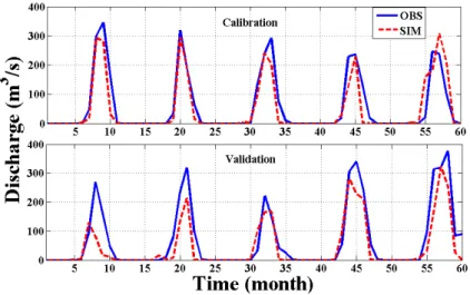
Firstly, SWAT was calibrated for the whole basin during the period 1989–1993 based on daily and monthly stream flow at the Al Gwisi hydrological station and the model inputs. Then, the model further validated over the period 1995–1999. Results showed
5
that SWAT could successfully simulate reasonable daily and monthly streamflow in the DRB as shown in Fig. 2. Particularly, the coefficient of determination (R2) and Nash–Sutcliffe coefficient of efficiency values (NSE) between monthly observed and simulated streamflow were 0.83 and 0.81 for the calibration period and 0.82 and 0.76 during the validation period, respectively. For the daily stimulation,R2and NSE values
10
were 0.63 and 0.61 for the calibration period and 0.56 and 0.51 for the validation period as listed in Table 2. According to the criteria of Moriasi et al. (2007), SWAT model in the DRB shows acceptable performance.
4.2 Future climate change
CF and QM methods were employed to downscale the climate variables for the
se-15
lected GCMs. In particular, the temperature data were downscaled using the CF ap-proach, whereas the precipitation was downscaled using the two approaches.
4.2.1 Mean ofTmaxandTmin
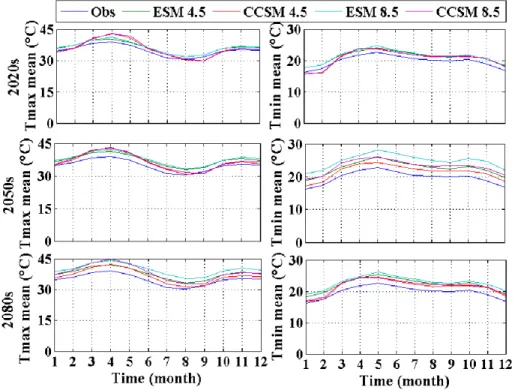
The future climate conditions were determined using the combination of climate change scenarios (RCP4.5 and RCP8.5) and GCMs (MPI-ESM-LR and CCSM4). Figure 3
20
represents the difference between maximum and minimum temperature in the future and the baseline period (1961–1990). ESM indicates to the MPI-ESM-LR model; while CCSM represents the CCSM4 model, and RCP4.5 and RCP8.5 demonstrate the cli-mate change scenarios. For instance; ESM4.5 shows the clicli-mate condition simulated by the MPI-ESM-LR model under the RCP4.5 climate change scenario. The maximum
HESSD
12, 10157–10195, 2015Impacts of climate change under CMIP5 RCP scenarios on the
streamflow in the Dinder River
A. K. Basheer et al.
Title Page
Abstract Introduction
Conclusions References
Tables Figures
◭ ◮
◭ ◮
Back Close
Full Screen / Esc
Printer-friendly Version
Interactive Discussion
Discussion
P
a
per
|
Discussion
P
a
per
|
Discussion
P
a
per
|
Discussion
P
a
per
temperature (Tmax) trend analysis shows an obvious increment in the future. However,
the change amplitude ofTmaxis uncertain due to differences in the applied GCMs
mod-els and scenarios. Annual average temperature increases ranges are between 0.9 to 1.6◦C, 1.5 to 2.9◦C and 1.7 to 4.9◦C in 2020s, 2050s and 2080s respectively, as shown in Table 3. Moreover, the RCP8.5 scenario predicted higher temperature increases than
5
that of RCP4.5 during the study periods. Under the same climate change scenario (RCP4.8 and RCP8.5), MPI-ESM-LR model projected higher temperature increases than CCSM4 model in 2020s, 2050s and 2080s. Whereas, 2080s period showed the highest increase change in temperature based on the two models. The magnitude of the monthly temperature increment showed more variation under MPI-ESM-LR model
10
with increase ranges from 0.8 to 3.9◦C, from 1.8 to 3.9◦C and from 2.2 to 6.2◦C in 2020s, 2050s and 2080s respectively. The temperature change in CCSM4 model fluc-tuated between−2.2 to 4.5◦C in 2020, from −0.9 to 4.2◦C in 2050s and from 0.1 to 5.7◦C in 2080s.
The projected annual minimum temperature (Tmin) variability showed a marked
up-15
ward trend overall periods and GCMs and scenarios as demonstrated in Fig. 3 and Table 4. Annual average minimum temperature increases ranged from 0.9 to 1.6◦C, from 1.6 to 3◦C and from 1.7 to 5.1◦C in 2020s, 2050s and 2080s respectively. Vari-ation in monthly temperature showed more fluctuVari-ation in MPI-ESM-LR model, with a range from 1.1 to 2◦C, from 2 to 3.4◦C and from 2.5 to 5.9◦C in 2020s, 2050s
20
and 2080s respectively. The CCSM4 model temperature change ranged from−1.4 to 2.1, from −0.02 to 2.1 and from 0.9 to 3.8 in 2020s, 2050s and 2080s respectively. Broadly, the expected temperature under different climate changes scenarios and con-ditions indicate that the overall climate will become much warmer as time passes. As shown in Table 4 the RCP8.5 scenario projected higher temperature increases than the
25
HESSD
12, 10157–10195, 2015Impacts of climate change under CMIP5 RCP scenarios on the
streamflow in the Dinder River
A. K. Basheer et al.
Title Page
Abstract Introduction
Conclusions References
Tables Figures
◭ ◮
◭ ◮
Back Close
Full Screen / Esc
Printer-friendly Version
Interactive Discussion
Discussion
P
a
per
|
Discussion
P
a
per
|
Discussion
P
a
per
|
Discussion
P
a
per
|
4.2.2 Mean precipitation
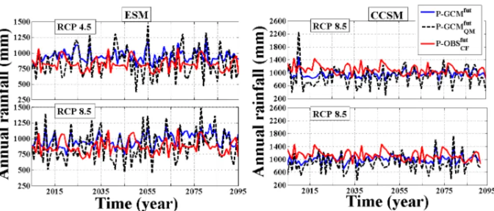
Figure 4 and Table 5 illustrate the projected change in annual precipitation under two GCMs and scenarios (RCP4.5 and RCP8.5), using CF and QM downscaling ap-proaches. Mean annual precipitation projected by CCSM4 model showed a dramatic increase when CF method is applied, while MPI-ESM-LR model showed a significant
5
upward trend during the same period. According to MPI-ESM-LR model, the mean annual precipitation changes ranged from 2.3 to 4.6 %, from 1.5 to 9.2 % and from 3 to 10.5 % in 2020s, 2050s and 2080s respectively, whereas CCSM4 model changes ranged from 40.4 to 42.5 %, from 35.3 to 39.7 % and from 28.1 to 36.2 % in 2020s, 2050s 2080s respectively. Conversely mean annual precipitation projected using the
10
QM method showed a convergent significant upward trend under the two models, as it is clearly shown in MPI-ESM-LR model prediction, which indicates an increase trend ranged between 6.5 to 14.9 % in 2020s, 2050s and 2080s. The CCSM4 model showed increment ranged between 6.7 to 16.4 % over the study periods. Despite annual pre-cipitation predicted by MPI-ESM-LR model under RCP8.5 scenario was displayed
con-15
vergent upward trend under the two downscaling methods, its distribution and amount were varied at the monthly and daily scale. The variation in the obtained downscaling results is because of the characteristic variability of CF and QM approaches. In case of applying the CF approach, any decrease/increase in daily rainfall series will be as a consequence of a decrease/increase in the monthly precipitation. However, in the
20
QM approach, the rainfall time series for the future period are taken from the GCM scenarios. The QM approach might predict an increment in maximum daily rainfall value, if a decrease in monthly precipitation is projected by GCM as shown by Camici et al. (2013).
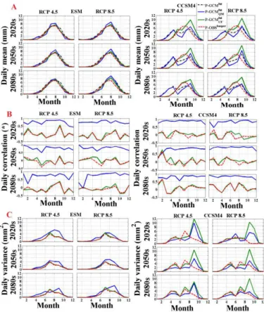
Figure 5a displays the relationship between the mean daily rainfall projected by two
25
HESSD
12, 10157–10195, 2015Impacts of climate change under CMIP5 RCP scenarios on the
streamflow in the Dinder River
A. K. Basheer et al.
Title Page
Abstract Introduction
Conclusions References
Tables Figures
◭ ◮
◭ ◮
Back Close
Full Screen / Esc
Printer-friendly Version
Interactive Discussion
Discussion
P
a
per
|
Discussion
P
a
per
|
Discussion
P
a
per
|
Discussion
P
a
per
daily rainfall when two downscaling methods were used. Conversely, high variation was detected in mean daily rainfall when the CF approach applied corresponding to CCSM4 outputs, whereas QM prediction varied slightly when applied. Moreover, the correlation between the mean daily rainfall projected by the CF, QM approaches and baseline period corresponding to the GCM outputs illustrated by Fig. 5b. Obviously, the QM
5
showed high correlation to GCMs outputs compared with the CF method. Furthermore, Fig. 5c demonstrates the variance of the mean daily rainfall generated by CF and QM relative to the simulations of the two GCMs. It is clearly there is a remarkable variance in mean daily rainfall provided by CCSM4 outputs compare with downscaled rainfall when the CF approach was applied.
10
From the results, there is uncertainty in projected temperature and precipitation due to the applied GCMs and downscaling approaches. Consequently, an uncertainty would be emerged in the predictions of future streamflow response.
4.3 Response of stream flow to climate change
4.3.1 Annual streamflow change
15
The potential effect of future climate change in annual streamflow generated by the outputs of the IMP-EMI-LR and CCSM4 models and tow downscaling approaches is shown in Table 6. It realized that, the expected change rate in 2020s, 2050s and 2080s fluctuated between 7.2 and 68.1 %, for the two models when CF approach ap-plied. While, the possible annual streamflow changes in the same period, when the
20
QM method applied is predicted to be ranged between−8.4 and 15.6 %. Whereas un-der RCP4.5 scenario for the MPI-ESM-LR model, the annual stream flow projected by the two downscaling methods nearly has convergent increase trend. RCP8.5 sce-nario indicated a different annual streamflow trend fluctuated between 13.9 to 29.0 % and from −8.4 to 6.0 % relative to QM and CF methods respectively. However, the
25
HESSD
12, 10157–10195, 2015Impacts of climate change under CMIP5 RCP scenarios on the
streamflow in the Dinder River
A. K. Basheer et al.
Title Page
Abstract Introduction
Conclusions References
Tables Figures
◭ ◮
◭ ◮
Back Close
Full Screen / Esc
Printer-friendly Version
Interactive Discussion
Discussion
P
a
per
|
Discussion
P
a
per
|
Discussion
P
a
per
|
Discussion
P
a
per
|
the CF approach is seemingly due to its high rainfall projection. Despite the projected streamflow varied between increase and decline, the increase trend was the dominate characteristic in streamflow prediction.
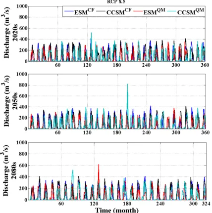
4.3.2 Monthly stream flow change
The mean monthly streamflow in 2020s under CCSM4 model and CF approach
ex-5
pected to be changed in June and October from 1.8 to 12.1 m3s−1 and from 79.6 to 197.5 m3s−1respectively and varied with percentage rate±18 % of baseline period in other months. While monthly streamflow predicted by applying the QM approach to the same model in June and October altered from 1.8 to 99.1 m3s−1 and from 79.6 to 159.9 m3s−1respectively and decreased in other months with percentage range of
10
67 %. Streamflow projected by IMP-ESM-LR model and CF method showed reason-able variability in June and October from 1.8 to 3.1 m3s−1and from 79.6 to 99.7 m3s−1 respectively and uptrend range of 81 % in all other months as shown in Figs. 6 and 7. However, by applying the QM method, streamflow increased significantly in June and October from 1.8 to 4.9 m3s−1 and from 79.6 to 126.9 m3s−1 respectively, while
15
other months were fluctuated within ±31 %. Although the percentage of streamflow increment in 2050 was somewhat less than that of 2020s, the prediction of IMP-ESM-LR and CCSM4 and two approaches generally showed a similar upward trend in the two periods. Similarly to 2020s and 2050s, the Monthly streamflow predictions for fu-ture periods 2080s showed the upward trend with a slight difference in the
magni-20
tude in some months comparing to baseline period. The high percentage of change in monthly streamflow which displayed by two GCMs under CF and QM approaches may be related to the seasonality of the river. In fact, any alterations in rainfall would result in greater percentage changes in runoff, and this true for monthly discharge val-ues obtained by CF and CCSM4 which dramatically increased in June and October
25
HESSD
12, 10157–10195, 2015Impacts of climate change under CMIP5 RCP scenarios on the
streamflow in the Dinder River
A. K. Basheer et al.
Title Page
Abstract Introduction
Conclusions References
Tables Figures
◭ ◮
◭ ◮
Back Close
Full Screen / Esc
Printer-friendly Version
Interactive Discussion
Discussion
P
a
per
|
Discussion
P
a
per
|
Discussion
P
a
per
|
Discussion
P
a
per
be decrease. This could be owing to the projection of high temperature increase dur-ing this period. Corresponddur-ing to IMP-EMI-LR, CCSM4 projected higher increment in streamflow over the study periods may be due to high temperature predicted by the first model.
Based on the results obtained in this study, there is an uncertainty in the simulated
5
streamflow under given climate change conditions, this uncertainty can be attributed to different sources of variability represented in future emissions scenarios, GCMs pro-jections, downscaling approaches and hydrological model parameterization.
4.4 Impact of climate change on DNP ecosystem habitats
4.4.1 Impact of climate change during the drought periods (1960s, 1970s and
10
1980s)
For the best of our knowledge, the DNP ecosystem has three major components namely woodlands (A. Seyal-Balanites), River stream and the Mayas (Wetlands). More-over, DNP ecosystem provides sustainable habitations for many species of Flora and Fauna, which they live or spend in it a part of essential key stages of their annual life
15
cycle. Precisely, River stream and the Mayas which offer sustainable refuge and pro-tection for the Living organisms after the flood season, they consider as a valuable store for that reactive link to keep on their flora and fauna existence until the next flood start and recharge the pools and Mayas (Hakim et al., 1978; Abdel Hameed and El-jack, 2003). It should be mentioned that the whole African countries during the last
20
five decades exposed to drought periods, which started in the 1960s and reached the peak in 1984. These drought, consequently, affected every Africa environmental systems; in particular, Sudan and Ethiopia (Mattsson and Rapp, 1991; Elagib and El-hag, 2011; Masih et al., 2014). Thus, climate change had pronounced effects on the DR stream and the Mayas through changed precipitation and occurrence of drought
25
HESSD
12, 10157–10195, 2015Impacts of climate change under CMIP5 RCP scenarios on the
streamflow in the Dinder River
A. K. Basheer et al.
Title Page
Abstract Introduction
Conclusions References
Tables Figures
◭ ◮
◭ ◮
Back Close
Full Screen / Esc
Printer-friendly Version
Interactive Discussion
Discussion
P
a
per
|
Discussion
P
a
per
|
Discussion
P
a
per
|
Discussion
P
a
per
|
the main agent in the wetlands ecosystem alteration, and accordingly influenced all the ecosystem components. This consistent with Woo et al. (1993) who pointed out that, the fate of the wetlands under climate change is mainly depending to changes in external recharge, which related to alterations in precipitation and evaporation over the wetland itself. Moreover, comparatively tiny increments in precipitation change can
5
significantly influence wetlands Flora and Fauna at various phases of their lives’ cycle (Keddy, 2000). As a result, the entire wetland’s ecosystem was affected by alterations in precipitation and streamflow (Bauder, 2005). Therefore, according to the seasonality of the DR, small decrease or increase in the annual rainfall leads to decline or increment the water level, and the impact will extend to the next seasons as happened during the
10
drought periods. The rainfall over DRB during the first drought period (1963 and 1965) and (1969 to 1972) declined about 23 and 11 %, respectively, which led to decline the runoffabout 47 % during (1972 to 1977). The second wave of drought started in 1978 to 1987 that decreased the rainfall about 14.8 %, led to decrease the runoffabout 20 %. These alterations caused a sharp decline in the DR runoff and seriously affected the
15
water availability in many Mayas. Moreover, the waves of drought followed by a flood season led to the remarkable damage in the river stream by closing the channels’ feeder from the main stream to Mayas and increasing the erosion and sedimentation. Consequently, it decreased the water amounts and many of Mayas dried. There are about 40 Mayas distributed in the DNP such as Ras Amir, Gadahat, and Godah
influ-20
enced by alterations in the rainfall trend during drought periods. Ras Amir considers as the largest Maya (4.5 km2), was dried up during the drought periods (1970) and since that time became less enduring, haphazardly every few years, and full of water in other years. Farash el Naam is the second biggest Maya (1.6 km2) after drought periods (1980) became more inconstant and lesser eternal. The last one is Godaha, consists
25
HESSD
12, 10157–10195, 2015Impacts of climate change under CMIP5 RCP scenarios on the
streamflow in the Dinder River
A. K. Basheer et al.
Title Page
Abstract Introduction
Conclusions References
Tables Figures
◭ ◮
◭ ◮
Back Close
Full Screen / Esc
Printer-friendly Version
Interactive Discussion
Discussion
P
a
per
|
Discussion
P
a
per
|
Discussion
P
a
per
|
Discussion
P
a
per
in terms of the components’ habitats in the DNP. Consequently, the damage in habitats impacted most of the flora and fauna in the DNP.
In this century, DNP habitats virtually certain expose to the climate change impact, such as temperature increment or rainfall increase and/or decline, which will very likely affect the flora and fauna and their migration, blooming and mating timing.
5
4.4.2 Impact of projected climate change on DNP ecosystem habitats
Based on the climate change projections’ scenarios, the changes in temperature and precipitation will impact either directly or indirectly the streamflow magnitude. Conse-quently, the DNP ecosystem will very likely be exposed to a variety of negative and positive effects based on these projections. Although climatic warming in this century
10
is expected to start a drying trend in wetland ecosystems in most parts of the world (Gorham, 1991), the results obtained by this work accomplished that the DRB wetlands will experience increment in water magnitude according to the projected increment in the annual streamflow. Generally, the temperature increase and greater changes in precipitation will occur in DNP over this century. The IMP-ESM-LR and CCSM4
mod-15
els projected annually increases in Tmax ranged from 0.9 to 4.9◦C and Tmin ranged
from 0.9 to 5◦C; the RCP8.5 scenario projected the greatest increase. Alterations in precipitation are projected to vary in spatially and temporally when CF and QM ap-proaches applied between 1.8 to 32.8 % and between 6.2 to 21.4 % respectively. DNP is expected to get drier in the summer, whereas more likely to be wetter in autumn. The
20
rainfall increment will be greater in the southeast part of DNP more than the northwest. Moreover, the intensity and the maximum magnitude of precipitation, will likely increase as well.
The upward trend in the rainfall amount which predicted by two models will have distinctive positive impacts on the DNP ecosystems in terms of habitat sustainability
25
HESSD
12, 10157–10195, 2015Impacts of climate change under CMIP5 RCP scenarios on the
streamflow in the Dinder River
A. K. Basheer et al.
Title Page
Abstract Introduction
Conclusions References
Tables Figures
◭ ◮
◭ ◮
Back Close
Full Screen / Esc
Printer-friendly Version
Interactive Discussion
Discussion
P
a
per
|
Discussion
P
a
per
|
Discussion
P
a
per
|
Discussion
P
a
per
|
in streamflow ranged between 7.2 to 68.1 % and between 3.4 to 15.6 % in the 2020s, 2050s and 2080s. These increases in the streamflow likely will be suitable amounts to restoration of the DNP ecosystem components. Despite, the rainfall increment pro-jected by CCSM4 apparently does not affect DNP ecosystem positively, the predicted rainfall pattern is totally different from the baseline period among rainy months. This
5
might lead to positive effect on the distribution of the water amount in flood season, which will increase water availability duration. DNP lies on the road of winter migration for many African birds during their pass to eastern Africa Rift valley lakes or southward. Accordingly, the increase of water during the flood season in this century will lead to in-crease the capacity of the Mayas and pools to receive more numbers of these migrant
10
birds. Furthermore, these habitats will not be a breed effective threat and danger on the life cycle for that birds and defect on the ecosystem balance of DNP and regional scale. Otherwise almost the two GCMs predictions indicated that precipitation most probably tends to increase in the future over the DNP. Consequently, this positive variation will likely greatly influence the water level in Mayas and pools and promote the intensity of
15
vegetation cover and growing of the grasses which consider a major food source for most DNP fauna.
On the other hand, the increment in precipitation intensity will likely increase the fre-quency of flooding, and landslides. This will likely generate increased rates of erosion and sedimentation, which causing a decrease of supply from stream channel banks
20
to the wetlands and the capacity. As stated in the two GCMs scenarios, which pro-jected significant annually and monthly increment in temperature. This increment will likely affect the habitats’ component in the DNP, as the water level will be affected by the evapotranspiration over the DRB, particularly under The IMP-ESM-LR model and RCP8.5 scenario at the end of this century.
25
HESSD
12, 10157–10195, 2015Impacts of climate change under CMIP5 RCP scenarios on the
streamflow in the Dinder River
A. K. Basheer et al.
Title Page
Abstract Introduction
Conclusions References
Tables Figures
◭ ◮
◭ ◮
Back Close
Full Screen / Esc
Printer-friendly Version
Interactive Discussion
Discussion
P
a
per
|
Discussion
P
a
per
|
Discussion
P
a
per
|
Discussion
P
a
per
to the southeast (Ethiopian Plateau), while the temperature decreases with the rainfall increase. This offers DNP ecosystem the same habitat with different climatic conditions (temperature and precipitation). Consequently, most of the fauna and flora have high resilience to adapt to the impact of the climate change and habitats’ loss as happened during drought periods. This implies that, during drought periods some of the fauna and
5
flora have changed their habitats to the areas that have the same climate conditions of their previous habitats as a form of adaptation. Furthermore, over the last 100 years, maximum temperature with mean rainfall as secondary driver was the determinant fac-tor in habitat loss and fragmentation, averaged across species and geographic regions. Habitat loss and fragmentation effects were greatest in areas with high maximum
tem-10
peratures. Conversely, they were lowest in areas where average rainfall has increased over time (Mantyka-pringle et al., 2012). Based on the projected climate determinants and DNP ecosystem characteristics, we inferred that, ecosystem components will likely expect to start restoration of ecosystem habitats.
5 Conclusion
15
The study analyzed the response of streamflow and ecosystem habitats in the DRB to possible future climate conditions change that predicted by using two GCMs coupled with two downscaling approaches and physically based distributed hydrologic model (SWAT). Predictions of two GCMs pointed out the temperature and precipitation will increase in the next century. Consequently, streamflow is likely will increase according
20
to rainfall increase. Type of the used downscaling approach was a key factor in cli-matic variables’ projection. The annual rainfall predicted by QM approach based on two GCMs tend to have the same increasing trend, particularly under RCP4.5 scenario. The CF approach showed huge increment with CCSM4 compare by IMP-ESM-LR. In con-trast, the IMP-ESM-LR model under both CF and QM approaches in RCP8.5 scenario,
25
HESSD
12, 10157–10195, 2015Impacts of climate change under CMIP5 RCP scenarios on the
streamflow in the Dinder River
A. K. Basheer et al.
Title Page
Abstract Introduction
Conclusions References
Tables Figures
◭ ◮
◭ ◮
Back Close
Full Screen / Esc
Printer-friendly Version
Interactive Discussion
Discussion
P
a
per
|
Discussion
P
a
per
|
Discussion
P
a
per
|
Discussion
P
a
per
|
regarded to the fact that the QM approach taken into account daily rainfall time series generated by the GCM. There is uncertainty in the Streamflow projection basically de-pended on the GCMs, scenarios, downscaling approach and model parameterization. Relying on prediction of potential possible changes in climate condition, ecosystem components in DNP substantially will likely be affected in a way that make that living
or-5
ganism habitats and life cycle will likely have recovery conditions rather than extinction and destruction circumstances, as it was happening during drought periods (1960s, 1970s and 1980s). On the other hand, the projected rainfall and the seasonality of the river will make more uneven distribution of annual flow from year to another. Thus, high attentions to extreme events (floods and drought) to avoid the negative
hydrologi-10
cal effect on the DNP ecosystem habitats should be considered. The presented study projected the hydroclimatic condition over DNP and assessed how ecosystem habitats respond to the changes of these variables. The results provide benchmark informa-tion that can be used to increase the capacity of the water resources management and ecosystem conservation strategies through identify suitable actions for the future.
15
That is to create more resilience to climate changes related to habitats restoration and continued management of other stressors in DNP ecosystem. Furthermore, integrity of hydrological conditions in DR stream and Mayas’ should be considered, to reduce the negative impact of climate change on fragmented wetlands’ ecosystem, practically in terms of drought and sediments.
20
Acknowledgement. The authors would like to thank the Sudan Ministry of Water Resources & Electricity, the Wildlife Research centre, Meteorological Authority and Nile basin initiative for providing us with the data. Thanks to Fen Ouyang PhD student at College of Hydrology and Water Resources, Hohai University, China and Elhassan Zakieldeen, Karary University, Engineering College, Sudan for their technical assistance. This research is supported by the
25
HESSD
12, 10157–10195, 2015Impacts of climate change under CMIP5 RCP scenarios on the
streamflow in the Dinder River
A. K. Basheer et al.
Title Page
Abstract Introduction
Conclusions References
Tables Figures
◭ ◮
◭ ◮
Back Close
Full Screen / Esc
Printer-friendly Version
Interactive Discussion
Discussion
P
a
per
|
Discussion
P
a
per
|
Discussion
P
a
per
|
Discussion
P
a
per
References
Abbaspour, K. C., Yang, J., Maximov, I., Siber, R., Bogner, K., Mieleitner, J., Zobrist, J., and Srinivasan, R.: Modelling hydrology and water quality in the pre-alpine/alpine Thur watershed using SWAT, J. Hydrol., 333, 413–430, 2007.
Abdel Hameed, S. M.: Vegetation of the Mayas of Dinder National Park, Colorado State
Uni-5
versity, Sudan, 1983.
Abdel Hameed, S. M. and Eljack, A. O.: Ramsar Information Sheet (RIS) for Dinder national park, Sudan, Wetlands International Global, available at: https://rsis.ramsar.org/RISapp/files/ RISrep/SD1461RIS.pdf (last access: 1 April 2015), 2013.
AbdelHameed, S. M., Awad, N. M., ElMoghraby, A. I., Hamid, A. A., Hamid, S. H., and
Os-10
man, O. A.: Watershed management in the Dinder National Park, Sudan, Agr. Forest Mete-orol., 84, 89–96, 1997.
Bauder, E.: The effects of an unpredictable precipitation regime on vernal pool hydrology, Fresh-water Biol., 50, 2129–2135, 2005.
Burkett, V. R., Wilcox, D. A., Stottlemyer, R., Barrow, W., Fagre, D., Baron, J., Price, J.,
15
Nielsen, J. L., Allen, C. D., and Peterson, D. L.: Nonlinear dynamics in ecosystem response to climatic change: case studies and policy implications, Ecol. Complex., 2, 357–394, 2005. Camici, S., Brocca, L., Melone, F., and Moramarco, T.: Impact of climate change on flood
fre-quency using different climate models and downscaling approaches, J. Hydrol. Eng., 19, 04014002, doi:10.1061/(ASCE)HE.1943-5584.0000959, 2013.
20
Charlton, R., Fealy, R., Moore, S., Sweeney, J., and Murphy, C.: Assessing the impact of cli-mate change on water supply and flood hazard in Ireland using statistical downscaling and hydrological modelling techniques, Climatic Change, 74, 475–491, 2006.
Chow, V. T., Maidment, D. R., and Mays, L. W.: Applied Hydrology, McGraw-Hill Series in Water Resources and Environmental Engineering, McGraw-Hill, New York, 572 pp., 1988.
25
Dasmann, W.: Development and management of Dinder National Park and its Wildlife, Rep. 3113, Food and Agriculture Organisation, Rome, Italy, 2–62, 1972.
Dessu, S. B. and Melesse, A. M.: Impact and uncertainties of climate change on the hydrology of the Mara River basin, Kenya/Tanzania, Hydrol. Process., 27, 2973–2986, 2013.
Diaz-Nieto, J. and Wilby, R. L.: A comparison of statistical downscaling and climate change
30
HESSD
12, 10157–10195, 2015Impacts of climate change under CMIP5 RCP scenarios on the
streamflow in the Dinder River
A. K. Basheer et al.
Title Page
Abstract Introduction
Conclusions References
Tables Figures
◭ ◮
◭ ◮
Back Close
Full Screen / Esc
Printer-friendly Version
Interactive Discussion
Discussion
P
a
per
|
Discussion
P
a
per
|
Discussion
P
a
per
|
Discussion
P
a
per
|
Döll, P. and Zhang, J.: Impact of climate change on freshwater ecosystems: a global-scale analysis of ecologically relevant river flow alterations, Hydrol. Earth Syst. Sci., 14, 783–799, doi:10.5194/hess-14-783-2010, 2010.
Elagib, N. A. and Elhag, M. M.: Major climate indicators of ongoing drought in Sudan, J. Hydrol., 409, 612–625, 2011.
5
Erwin, K. L.: Wetlands and global climate change: the role of wetland restoration in a changing world, Wetl. Ecol. Manage., 17, 71–84, 2009.
Ficklin, D. L., Luo, Y., Luedeling, E., Gatzke, S. E., and Zhang, M.: Sensitivity of agricultural runoffloads to rising levels of CO2and climate change in the San Joaquin Valley watershed of California, Environ. Pollut., 158, 223–234, 2010.
10
Finlayson, C. M., Gitay, H., Bellio, M. G., van Dam, R. A., and Taylor, I.: Climate variability and change and other pressures on wetlands and waterbirds: impacts and adaptation, Waterbirds Around the World, edited by: Boere, G. C., Galbraith, C. A., and Stroud, D. A., The Stationery Office, Edinburgh, 88–97, 2006.
Fowler, H., Blenkinsop, S., and Tebaldi, C.: Linking climate change modelling to impacts studies:
15
recent advances in downscaling techniques for hydrological modelling, Int. J. Climatol., 27, 1547–1578, 2007.
Gitay, H., Suárez, A., Watson, R. T., and Dokken, D. J.: Climate Change and Biodiversity, In-tergovernmental Panel on Climate Change, IPCC Technical Paper V, 77 pp., IPCC, Geneva, 2002.
20
Gorham, E.: Northern peatlands: role in the carbon cycle and probable responses to climatic warming, Ecol. Appl., 1, 182–195, 1991.
Hakim, S., Fadlalla, B., Awad, N. M., and Wahab., S. A.: Ecosystems of the vegetation of Dinder national park, Unpublished report, Wildlife Research Unit, Khartoum, Sudan, 1978.
Hay, L. E., Wilby, R. L., and Leavesley, G. H.: A comparison of delta change and downscaled
25
GCM scenarios for three mounfainous basins in the United States, Jawra, J. Am. Water Resour. As., 36, 387–397, 2000.
Mantyka-pringle, C. S., Martin, T. G., and Rhodes, J. R.: Interactions between climate and habitat loss effects on biodiversity: a systematic review and meta-analysis, Global Change Biol., 18, 1239–1252, 2012.
30
HESSD
12, 10157–10195, 2015Impacts of climate change under CMIP5 RCP scenarios on the
streamflow in the Dinder River
A. K. Basheer et al.
Title Page
Abstract Introduction
Conclusions References
Tables Figures
◭ ◮
◭ ◮
Back Close
Full Screen / Esc
Printer-friendly Version
Interactive Discussion
Discussion
P
a
per
|
Discussion
P
a
per
|
Discussion
P
a
per
|
Discussion
P
a
per
Mattsson, J. O. and Rapp, A.: The recent droughts in western Ethiopia and Sudan in a climatic context, Ambio, 20, 172–175, 1991.
Millennium Ecosystem Assessment: Ecosystems and Human Well-being: Biodiversity Synthe-sis, Island Press, Washington, D.C., 2005.
Moriasi, D., Arnold, J., Van Liew, M., Bingner, R., Harmel, R., and Veith, T.: Model evaluation
5
guidelines for systematic quantification of accuracy in watershed simulations, T. ASABE, 50, 885–900, 2007.
Nash, J. and Sutcliffe, J. V.: River flow forecasting through conceptual models part I – a discus-sion of principles, J. Hydrol., 10, 282–290, 1970.
Neitsch, S., Arnold, J., Kiniry, J., Srinivasan, R., and Williams, J.: Soil and Water Assessment
10
Tool User’s Manual: Version 2000, GSWRL Report 02-02, BRC Report 02-06, Publ. Texas Water Resources Institute, TR-192, College Station, Texas, 2002.
Neitsch, S., Arnold, J., Kiniry, J., Srinivasan, R., and Williams, J.: Soil and Water Assessment Tool Input/Output File Documentation, Blackland Research Center, Temple, Texas, 2005a. Neitsch, S., Arnold, J., Kiniry, J., Williams, J., and King, K.: Soil and Water Assessment Tool
15
Theoretical Documentation, Grassland, Soil and Water Research Laboratory, Temple, Texas, 2005b.
Poff, N. L. and Ward, J. V.: Implications of streamflow variability and predictability for lotic com-munity structure: a regional analysis of streamflow patterns, Can. J. Fish. Aquat. Sci., 46, 1805–1818, 1989.
20
Poff, N. L. and Zimmerman, J. K.: Ecological responses to altered flow regimes: a literature review to inform the science and management of environmental flows, Freshwater Biol., 55, 194–205, 2010.
Sennikovs, J. and Bethers, U.: Statistical downscaling method of regional climate model results for hydrological modelling, in: Proc. 18 World IMACS/MODSIM Congress, Cairns, Australia,
25
2009.
Setegn, S. G., Rayner, D., Melesse, A. M., Dargahi, B., and Srinivasan, R.: Impact of cli-mate change on the hydroclimatology of Lake Tana Basin, Ethiopia, Water Resour. Res., 47, W04511, doi:10.1029/2010WR009248, 2011.
Steele-Dunne, S., Lynch, P., McGrath, R., Semmler, T., Wang, S., Hanafin, J., and Nolan, P.:
30
HESSD
12, 10157–10195, 2015Impacts of climate change under CMIP5 RCP scenarios on the
streamflow in the Dinder River
A. K. Basheer et al.
Title Page
Abstract Introduction
Conclusions References
Tables Figures
◭ ◮
◭ ◮
Back Close
Full Screen / Esc
Printer-friendly Version
Interactive Discussion
Discussion
P
a
per
|
Discussion
P
a
per
|
Discussion
P
a
per
|
Discussion
P
a
per
|
Tavakoli, M. and De Smedt, F.: Impact of climate change on streamflow and soil moisture in the Vermilion Basin, Illinois, J. Hydrol. Eng., 17, 1059–1070, doi:10.1061/(ASCE)HE.1943-5584.0000546, 2011.
Teutschbein, C. and Seibert, J.: Bias correction of regional climate model simulations for hydro-logical climate-change impact studies: review and evaluation of different methods, J. Hydrol.,
5
456, 12–29, 2012.
Thom, H. C.: A note on the gamma distribution, Mon. Weather Rev., 86, 117–122, 1958. Thomas, C. D., Cameron, A., Green, R. E., Bakkenes, M., Beaumont, L. J., Collingham, Y. C.,
Erasmus, B. F., De Siqueira, M. F., Grainger, A., and Hannah, L.: Extinction risk from climate change, Nature, 427, 145–148, 2004.
10
Whiteman, A.: Tho Geology of the Sudan Republic, Clarendon Press, Oxford University Press, London, 1971.
Wilby, R. L., Dawson, C. W., and Barrow, E. M.: SDSM – a decision support tool for the assess-ment of regional climate change impacts, Environ. Model. Softw., 17, 145–157, 2002. Woo, M.-K., Rowsell, R. D., and Clark, R. G.: Hydrological classification of Canadian prairie
15
wetlands and prediction of wetland inundation in response to climatic variability, Occasional Paper No. 79, Canadian Wildlife Service, Saskatoon, Canada, 1–24, 1993.
HESSD
12, 10157–10195, 2015Impacts of climate change under CMIP5 RCP scenarios on the
streamflow in the Dinder River
A. K. Basheer et al.
Title Page
Abstract Introduction
Conclusions References
Tables Figures
◭ ◮
◭ ◮
Back Close
Full Screen / Esc
Printer-friendly Version
Interactive Discussion
Discussion
P
a
per
|
Discussion
P
a
per
|
Discussion
P
a
per
|
Discussion
P
a
per
Table 1.Information of coupled climate models.
Model name Model centre Resolution
HESSD
12, 10157–10195, 2015Impacts of climate change under CMIP5 RCP scenarios on the
streamflow in the Dinder River
A. K. Basheer et al.
Title Page
Abstract Introduction
Conclusions References
Tables Figures
◭ ◮
◭ ◮
Back Close
Full Screen / Esc
Printer-friendly Version
Interactive Discussion
Discussion
P
a
per
|
Discussion
P
a
per
|
Discussion
P
a
per
|
Discussion
P
a
per
|
Table 2.Calibration (1989–1993) and validation (1995–1999) of SWAT model.
Period NS R2
Monthly
Calibration (1989–1993) 0.81 0.83 Validation (1995–1999) 0.76 0.82 Daily
HESSD
12, 10157–10195, 2015Impacts of climate change under CMIP5 RCP scenarios on the
streamflow in the Dinder River
A. K. Basheer et al.
Title Page
Abstract Introduction
Conclusions References
Tables Figures
◭ ◮
◭ ◮
Back Close
Full Screen / Esc
Printer-friendly Version
Interactive Discussion
Discussion
P
a
per
|
Discussion
P
a
per
|
Discussion
P
a
per
|
Discussion
P
a
per
Table 3.Annual changes inTmaxin the future under two GCMs and two scenarios (RCP4.5 and
RCP8.5) at the upstream positions of the DRB.
Period’s Annual change inTmax(◦C)
MPI-ESM-LR CCSM4
RCP4.5
2020s 1.4 0.9
2050s 2.4 1.5
2080s 3.0 1.7
RCP8.5
2020s 1.6 1.0
2050s 2.9 1.9
HESSD
12, 10157–10195, 2015Impacts of climate change under CMIP5 RCP scenarios on the
streamflow in the Dinder River
A. K. Basheer et al.
Title Page
Abstract Introduction
Conclusions References
Tables Figures
◭ ◮
◭ ◮
Back Close
Full Screen / Esc
Printer-friendly Version
Interactive Discussion
Discussion
P
a
per
|
Discussion
P
a
per
|
Discussion
P
a
per
|
Discussion
P
a
per
|
Table 4.Annual changes inTminin the future under two GCMs and two scenarios (RCP4.5 and
RCP8.5) at the upstream portions of the DRB.
Period’s Annual change inTmin(◦C)
MPI-ESM-LR CCSM4
RCP4.5
2020s 1.4 0.9
2050s 2.4 1.6
2080s 2.9 1.7
RCP8.5
2020s 1.6 0.9
2050s 3.0 1.9