www.adv-geosci.net/32/49/2012/ doi:10.5194/adgeo-32-49-2012
© Author(s) 2012. CC Attribution 3.0 License.
Geosciences
Potential climate change impacts on the water balance of
subcatchments of the River Spree, Germany
I. Pohle1, H. Koch2, and U. Gr ¨unewald1
1Chair of Hydrology and Water Resources Management, Brandenburg University of Technology Cottbus,
Konrad-Wachsmann-Allee 6, 03046 Cottbus, Germany
2Potsdam Institute for Climate Impact Research: Climate Impacts and Vulnerabilities, Telegrafenberg A62,
14473 Potsdam, Germany
Correspondence to:I. Pohle ([email protected])
Received: 30 January 2012 – Revised: 31 July 2012 – Accepted: 4 November 2012 – Published: 11 December 2012
Abstract.Lusatia is considered one of the driest regions of Germany. The climatic water balance is negative even under current climate conditions. Due to global climate change, in-creased temperatures and a shift of precipitation from sum-mer to winter are expected. Therefore, it is of major interest whether the excess water in winter can be stored and to which extent it is used up on increasing evapotranspiration.
Thus, this study focuses on estimating potential climate change impacts on the water balance of two subcatchments of the River Spree using the Soil and Water Integrated Model (SWIM). Climate input was taken from 100 realisations each of two scenarios of the STatistical Analogue Resampling scheme STAR assuming a further temperature increase of 0 K (scenario A) and 2 K by the year 2055 (scenario B) re-spectively. Resulting from increased temperatures and a shift in precipitation from summer to winter actual evapotranspi-ration is supposed to increase in winter and early spring, but to decrease in later spring and early summer. This is less pro-nounced for scenario A than for scenario B. Consequently, also the decrease in discharge and groundwater recharge in late spring is lower for scenario A than for scenario B. The highest differences of runoff generation and groundwa-ter recharge between the two scenarios but also the high-est ranges within the scenarios occur in summer and early autumn. It is planned to estimate potential climate change for the catchments of Spree, Schwarze Elster and Lusatian Neisse.
1 Introduction
During the past decades a decrease in summer rainfall, an increase in winter precipitation and an increase in tempera-ture in all seasons, especially in winter, has been observed for Germany (Sch¨onwiese et al., 2006) and more detailed for Saxony (Franke et al., 2004). Further studies about potential climate impacts on the water balance of river catchments in Brandenburg and Saxony (Gerstengarbe et al., 2003; Wege-henkel and Kersebaum, 2009; Hattermann et al., 2008) found a decreasing climatic water balance and water yield in the region. Due to temperature increase, higher potential evapo-transpiration can be expected, e.g. caused by a longer vegeta-tion period. Likewise, this results also in higher actual evap-otranspiration unless limited by water yield. Changes in pre-cipitation and temperature both cause changes in runoff gen-eration and river discharge; even small changes can highly affect groundwater recharge (Arnold et al., 1993).
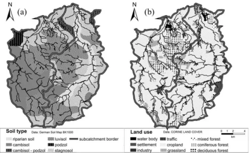
Fig. 1.General maps of the study region:(a)soil map,(b)land use map for the subcatchments of River Schwarzer Schoeps (left) and Weisser Schoeps (right).
2 Data and methods
2.1 Study region
Lusatia is located in Eastern Germany, more precisely in the south of Brandenburg and in the east of the Free State of Saxony. Its major rivers are the Spree, the Schwarze El-ster and the Lusatian Neisse. Due to lignite mining activ-ities the water balance of Lusatia is profoundly disturbed (Gr¨unewald, 2001). Groundwater resources have been re-duced by dewatering large areas in order to extract lignite in open cast mines. River discharges have been increased by mine discharges and annual variations have been evened out. Due to those interventions on the hydrological sys-tem there is no natural relation between rainfall and runoff. This makes it difficult to calibrate water balance models for larger areas based on observed discharges. Therefore, this study concentrates on two subcatchments of the River Spree without influence of both water management and mining activities: the River Schwarzer Schoeps up to Jaenkendorf gauge (A= 115 km2) and the River Weisser Schoeps up to Saerichen gauge (A= 135 km2). Both subcatchments are lo-cated in the east of Saxony in a hilly area. Long term an-nual precipitation for both subcatchments is about 650 mm; mean annual temperature is about 8◦C. Dominating soil types are luvisols, cambisols and stagnosols; riparian soils can be found in the floodplain of Weisser Schoeps (Fig. 1a). The dominating land use is cropland (70 %), 15 % of the area is forested, whereby coniferous forests are dominating (Fig. 1b). Grassland accounts for 5 % of the area and settle-ments (5 %) mostly stretch along the rivers. Further forms of land use in the area are water bodies, industry and traffic infrastructure.
2.2 Regional climate model STAR
Using the STatistical Analogue Resampling scheme STAR time series of climate parameters by resampling segments of daily observations can be created. Simulated time series are forced only by the linear air temperature trend of the future period (Huang et al., 2010). One of the scenarios used in this analysis assumes no further climate change in the study re-gion from now on, but includes a temperature increase of 0.6 K compared to the reference period because the recent years were already warmer than the reference period (sce-nario A). The second sce(sce-nario assumes a further warming of 2 K until 2055 in the study region (scenario B). Due to the assumed linear temperature trend in scenario B the mean an-nual temperature in 2020 is increased by 0.5 K, for the middle of the scenario period the temperature increase is 1.2 K re-spectively. A number of 100 realisations were used for 2007– 2055.
2.3 Hydrological modelling with SWIM
Fig. 2.Ratio between precipitation (P) of the scenarios and the ref-erence period, Weisser Schoeps.
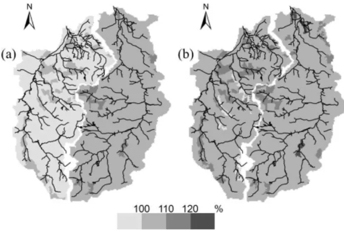
Fig. 3.Ratio between annual actual evapotranspiration for the sce-narios and the reference period(a)scenario A,(b)scenario B.
both subcatchments, correcting precipitation by wind. Agri-culture is parameterized as a crop rotation dominated by win-ter wheat as typical of the region; the same crop is calculated for all hydrotopes. The model calibration is done for 2002– 2004 and the validation for 1998–2001 and 2005–2006, re-spectively, using an identical parameter set for both sub-catchments. As the general hydrograph but especially flow volumes and low flow periods are of interest in this study, the model performance is evaluated using the Nash-Sutcliffe model efficiency coefficient NSE (Nash and Sutcliffe, 1970), the Nash-Sutcliffe model efficiency coefficient with loga-rithmic values of observed and simulated daily discharge NSElog, the relative volume error RVE and Pearson’s
cor-relation coefficientR2(Table 1). A satisfying model perfor-mance was achieved for both catchments (Table 1). Water balance components simulated for observed climate data of the standard normal period (1961–1990) as reference period were compared to those simulated for the scenario period 2020–2055.
3 Results and discussion
For illustration purposes, Fig. 2 shows the ratio between pre-cipitation (P) for the scenarios and the reference period for the Weisser Schoeps catchment. The box plot visualizes both
Fig. 4.Ratio between actual evapotranspiration (ETA) for the sce-narios and the reference period, Weisser Schoeps.
Fig. 5.Ratio between annual runoff generation for the scenarios and the reference period(a)scenario A,(b)scenario B.
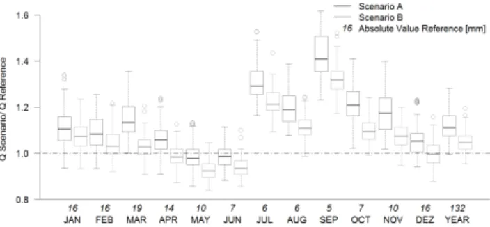
change much for scenario A, but increased for scenario B due to a higher temperature increase. Runoff generation for scenario A was higher than for the reference in almost all hydrotopes, but mostly lower for scenario B (Fig. 5). For forest and grass land it did not change for scenario A, but significantly decreased for scenario B resulting from higher actual evapotranspiration. Figure 6 shows that for both sce-narios increasing discharges were simulated for late summer, autumn and winter with highest ratios in July and Septem-ber (about 25 % or more increase). A slight decrease of dis-charge was simulated for May and June with higher effects for scenario B. Higher discharges in autumn might be caused by higher precipitation in July and September. Lower dis-charges in May and June were caused by declining climatic water balance in those months. Groundwater recharge in-creased for scenario A in most areas, but dein-creased in grass-land areas (Fig. 7). For scenario B a decrease occurred es-pecially on forest and grassland. During the year, ground-water recharge was decreased by up to 10 % for scenario A and somewhat more for scenario B on average. Decreas-ing groundwater recharge can be explained with lower wa-ter availability which is caused by higher actual evapotran-spiration in spring. The changes during the months had the same tendency as those in runoff; only the percentage of de-crease was higher (Fig. 8). In May and June water availability was lowest, so groundwater recharge reached a minimum and the highest decrease occured (about −50 %). Groundwater
recharge in September increased due to higher precipitation in this month and just slightly increased actual evapotranspi-ration. All in all, groundwater recharge is the smallest water balance component in the study region, hence small differ-ences in total numbers can cause high numbers in percentage deviation.
4 Conclusion and outlook
Climate impacts on water balance components of the two subcatchments examined differed on a spatial scale but were rather equal on a temporal scale. For scenario A slightly in-creasing precipitation compensated the effects of inin-creasing actual evapotranspiration due to temperature increase for the whole year compared to the reference period. Both river dis-charges and groundwater recharge slightly increased com-pared to the reference period. In scenario B no significant precipitation trend occurred for the whole year. However, in
Fig. 6.Ratio between discharge (Q) of the scenarios and the refer-ence period, Weisser Schoeps.
combination with higher actual evapotranspiration the wa-ter availability was reduced. The river discharge increased for the whole year, while groundwater recharge decreased. Decreased water availability in June and July might cause water stress. Both ranges and differences of the water bal-ance components were much higher on a monthly basis than for the whole year. The highest differences between the two scenarios and the reference period as well as the highest ranges within the scenarios were noticed in summer and early autumn. The ranges of all water balance components were higher for scenario A than for scenario B. Seasonality of land use as well as soil type affected climate impact on spatial scale.
Uncertainties in this study can be found both in the hy-drological modelling and in the climate model itself. For the hydrological model uncertainties can be found in the input values, like discharge measurements and also soil and land use data. Additionally, measured discharges may not only result from a natural rainfall – runoff relationship, but may also be affected by anthropogenic influences such as pond fishery. In hydrological modelling, there is often the risk of achieving similar results with different parameter sets due to equifinality. In order to reduce the risk of equifinality, inde-pendent calibration and validation periods are chosen, both including dry and wet years. As two subcatchments, which are similar in most of their characteristics such as topogra-phy, land use and soil, achieve satisfactory performance for several criteria using the same parameter set, the risk of equi-finality is reduced. Uncertainties in the climate model cannot be accounted for in this paper. The question is not “how will the future be like”, but how the potential climate change im-pacts the water balance assuming STAR scenarios A and B using 100 realisations each. The high bandwidth in long term monthly means of these 100 realisations of the two scenarios shows a high range of potential climate change impacts. For individual years, the water balance components might be out-side of that bandwidth even.
climate scenarios should be included. It is planned to enlarge the study area for the Lusatian parts of the catchments of Spree, Schwarze Elster and Lusatian Neisse. As various land use changes are expected in that region, also land use change impact studies are to be conducted.
Acknowledgements. The authors acknowledge the International Graduate School at Brandenburg University of Technology for funding. Measured discharge data for the study region were delivered by S¨achsisches Landesamt f¨ur Umwelt, Landwirtschaft und Geologie.
Edited by: K. Schneider and S. Achleitner
Reviewed by: K. Drastig and one anonymous referee
References
Arnold, J. G., Allen, P. M., and Bernhardt, G.: A comprehen-sive surface-groundwater flow model, J. Hydrol., 142, 47–69, doi:10.1016/0022-1694(93)90004-s, 1993.
Conradt, T., Koch, H., Hattermann, F., and Wechsung, F.: Spatially differentiated management-revised discharge scenarios for an in-tegrated analysis of multi-realisation climate and land use scenar-ios for the Elbe River basin, Reg. Environ. Change, 12, 633–648, doi:10.1007/s10113-012-0279-4, 2012.
Franke, J., Goldberg, V., Eichelmann, U., Freydank, E., and Bern-hofer, C.: Statistical analysis of regional climate trends in Sax-ony, Germany, Clim. Res., 27, 145–150, doi:10.3354/cr027145, 2004.
Gerstengarbe, F.-W., Badeck, F., Hattermann, F. F., Krysanova, V., Lahmer, W., Lasch, P., Stock, M., Suckow, F., Wechsung, F., and Werner, P. C.: Studie zur Klimatischen Entwicklung im Land Brandenburg bis 2055 und deren Auswirkungen auf den Wasshaushalt, die Forst- und Landwirtschaft sowie die Ableitung er-ster Perspektiven, PIK, Potsdam, 2003.
Gr¨unewald, U.: Water resources management in river catchments influenced by lignite mining, Ecol. Eng., 17, 143–152, 2001. Hattermann, F. F., Krysanova, V., Wechsung, F., and
Watten-bach, M.: Integrating groundwater dynamics in regional hy-drological modelling, Environ. Modell. Softw., 19, 1039–1051, doi:10.1016/j.envsoft.2003.11.007, 2004.
Hattermann, F. F., Post, J., Krysanova, V., Conradt, T., and Wech-sung, F.: Assessment of Water Availability in a Central-European River Basin (Elbe) under Climate Change, Adv. Clim. Change. Res., 4, 42–50, 2008.
Huang, S. C., Krysanova, V., Osterle, H., and Hattermann, F. F.: Simulation of spatiotemporal dynamics of water fluxes in Ger-many under climate change, Hydrol. Process., 24, 3289–3306, doi:10.1002/hyp.7753, 2010.
Krysanova, V., Meiner, A., Roosre, J., and Vasilyev, A.: Simulation modeling of the coastal waters pollution from agricultural water-shed, Ecol. Model., 49, 7–29, doi:10.1016/0304-3800(89)90041-0, 1989.
Krysanova, V., M¨uller-Wohlfeil, D. I., and Becker, A.: Develop-ment and test of a spatially distributed hydrological water quality model for mesoscale watersheds, Ecol. Model., 106, 261–289, 1998.
Krysanova, V., Wechsung, F., Arnold, J., Srinivasan, R., and Williams, J.: SWIM (Soil and Water Integrated Model) User Manual, Potsdam Institute for Climate Impact Research, Pots-dam, 239 pp., 2000.
Krysanova, V., Hattermann, F. F., and Habeck, A.: Expected changes in water resources availability and water quality with re-spect to climate change in the Elbe River basin (Germany), Nord. Hydrol., 36, 321–333, 2005.
Nash, J. E. and Sutcliffe, J. V.: River Flow Forecasting Through Conceptual Models – Part I – A Discussion of Principles, J. Hy-drol., 10, 282–290, 1970.
Orlowsky, B., Gerstengarbe, F.-W., and Werner, P. C.: A resam-pling scheme for regional climate simulations and its perfor-mance compared to a dynamical RCM, Theor. Appl. Climatol., 92, 209–223, 2008.
Sch¨onwiese, C.-D., Staeger, T., and Troemel, S.: Klimawandel und Extremereignisse in Deutschland, Offenbach, 7–17, 2006. Wegehenkel, M. and Kersebaum, K. C.: An assessment of the