Int. j. econ. env. geol. Vol:3(2), 5-11, 2012
Introduction
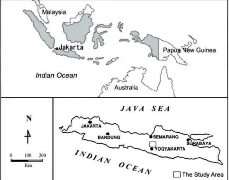
The study was carried out in the area of around Mount
Merapi, while the volcano is located within densely populated territory of Central Java province and
Analysis on the Capacity Building Efforts for Mitigating Volcanic
Risks during 2010 Eruption of Mount Merapi, Central Java, Indonesia
SARI BAHAGIARTI KUSUMAYUDHA
UPN Veteran, Jl SWK 104, Condongcatur, Yogyakarta 55283, Indonesia
STTNas, Jl Babarsari, Yogyakarta 55281, Indonesia
E-mail: [email protected]
Yogyakarta special region (Fig. 1). As it is known, Mount Merapi belongs to the most active volcano of Indonesia, and is one of the most attractive volcanoes for volcanologists in the world. Once in every about 4 years its activity increases, threatening surrounding environment Abstract. Mount Merapi is one of the most active volcanoes on the World erupted again during October to November 2010. Its climax activities happened on 5th
November at 00.10 pm, with different type of eruption from Mount Merapi of last 50 years. Ordinary, Mount Merapi activity starts from lava dome development, followed by dome collapse to create pyroclastic flow. This specific character of eruption is called Merapi type. The pyroclastic flows at that time killed 341 people and buried many villages on the southeastern slope, while the secondary hazard of lahar destroyed many other human settlements and infrastructures on the western slope of the volcano. Actually, capacity building program in the areas of around Mount Merapi has been established since more than 15 years ago. In most villages, there are community associations that well trained on volcanic hazard mitigation and early warning system. The association name is Association of Mountains Belt of Merapi. Map of Mount Merapi hazards was also already set by the Center of Volcanology and Geologic Disaster Mitigation. Unfortunately, human are not able to order the nature. The character of Mount Merapi eruption in the year 2010 was inconsistent. There was much higher gas pressure, much longer distant of pyroclastic flow, and much greater volume of volcanic material poured from the crater. This made people and stake holders very astonished in handling the evacuation. However, a socio-cultural factor in this respect is that the local people and agriculturists view Mount Merapi as a God which gives them fertile soil and water for agriculture and are reluctant to move away even under an impending threat of a volcanic hazard. This mind-set of people is a challenge in capacity building as the people prefer in-situ protective measures rather than moving away.
Fig. 1. Map showing location of the study area
ÓSEGMITE
with its phenomenal pyroclastic flows, glowing clouds, and lahar. In the year 2006, Mount Merapi showed its force, and erupted on 14 June, burying a tourist object at Kaliadem of Cangkringan district, Sleman regency. In October to November 2010 Mount Merapi was active again with different characteristic of eruption, killing many people and wiping out numerous villages of Cangkringan district, Kemalang district, and Magelang regency. Although the volcano is sometimes dangerous, but it brings blessings to the surrounding area by supplying sands, stones, fertile land, and beautiful scenery. This paper reports and analyzes the characteristics of Mount Merapi eruption 2010, its impact to surrounding areas, and the capacity building of local communities in terms of volcanic hazards mitigation. Methods applied in this study were field surveying, mapping, and primary or secondary data analysis.
Mount Merapi the active volcano. Mount Merapi is classified into a very active and very young volcano. Camus et al., (2000) infer the earliest growth of the volcano began at least 40,000 years B.P. (Newhall et al.,
2006). Historical records verify that the character of Mount Merapi eruption is dynamic and changed by time. Variation of effusive and explosive types have occurred,
shown by diverse volcanic products such as thick lavas, widespread volcanic sand, ash and dust deposits, pyroclastic breccia, and auto breccias (Kusumayudha 2001 and 2008).
Mount Merapi stands on the intersection of two volcanic lineaments, i.e. Ungaran - Telomoyo - Merbabu - Merapi and Lawu - Merapi - Sumbing - Sundoro Slamet (Fig. 2). Mount Merapi also lays on the meeting point of Semarang fault and Solo fault (Fig. 3). The volcano exists due to the subduction of Indo-australia oceanic plate to Eurasia continental plate. Partial melting beneath 75 to 125 km depth brings about calc-alkaline magma, as the source of Merapi products. Based on geophysical investigation, it is identified that the magma chamber of Merapi is relatively shallow, i.e. about 3 km bellow the ground surface (Sri Brotopuspito, 2006), the magma is very viscous, and its gas pressure is relatively low. This condition makes Merapi activity just displaying weak explosion, lava dome development, and nuee ardentes davalanche (Kusumadinata, 1979).
According to Camus et al., (2000), there are four periods of Merapi volcanic activities, comprising ancient Merapi period, middle Merapi period, recent Merapi period, and modern Merapi period. Ancient Merapi period is
Fig. 2. Volcanic lineaments of Ungaran-Telomoyo-Merbabu- Marapi and Lawu-Merapi-Sumbing-Sundoro-Slamet on the physiographic map of Centraleast Java (Van Bemmelen, 1949)
Fig. 3. Tectonic map of Java (Riswandi & Purwanto, 2008)
characterized by thick olivine andesite lava. The middle Merapi period produced thick andesitic lava flows and
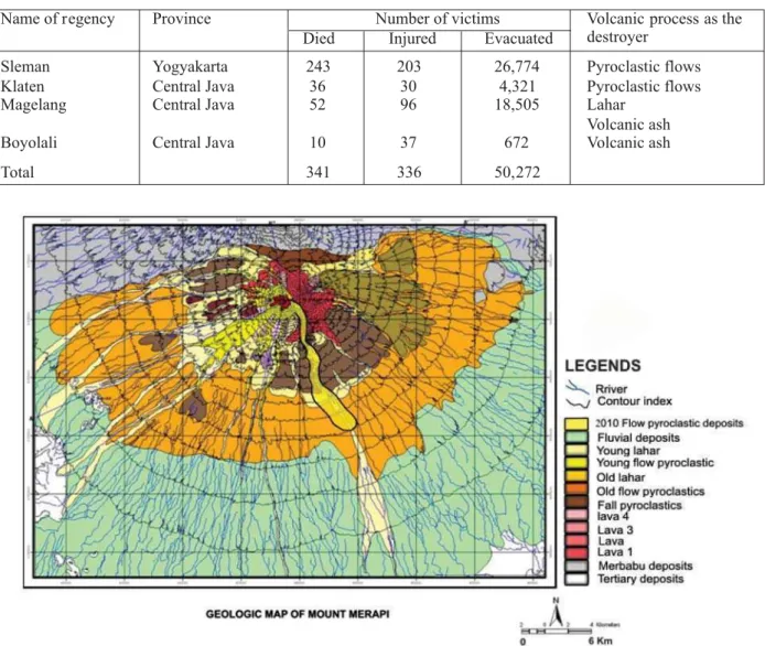
nuee ardentes deposits. The products of recent Merapi period are thin lava flows, pyroclastics and epiclastic deposits. Meanwhile modern Merapi period is specified by the Merapi type of eruptions, i.e. a continuous growth of summit dome, followed by collapses and phases of quiescence (Camus et al., 2000). The figure 4 below is the geologic map of Mount Merapi after 2010 eruption (Paripurno, 2006).
The 2010 eruption. Mount Merapi eruption of 2010 was most in the last 50 years. This time movement of the magma was too fast. According to the Institute of Research and Development of Volcanic Technology (IRDVT), the energy of Mount Merapi eruption of 2010 was many times higher than that of 2006 eruption. In the year 2010, since the activity level was pointed to be updated from normal active level to be first alert level, second alert level, and then third alert level, there was no glowing lava flows or dome detected on the summit. But suddenly Mount Merapi erupted and exploded on 26 October 2010. When Mount Merapi erupted in 2010, everyone was not well prepared yet. The eruption was more explosive,
higher gas pressure, and tremendous nuee ardentes (Fig. 5). The climax eruption occurred on 5 November early morning. According to the National Board of Disaster Prevention BNPB (2010) (http://www.bnpb.go.id/ irw/berita. asp?id=247), and Kompas daily newspaper (2012), 341 people died, 366 injured, 50,272 evacuated, and 3,307 buildings destroyed (Table 1). The cost of material lost was estimated approximately 4,230 billion rupiahs, including agricultures.
Mount Merapi eruption of 2010 can be classified into Vulcanian type with more than 5 km high rise dark smokes. Besides upward explosion, the eruptions was also combined with nuee ardentesdavalanche as ever happened to Mount St Helens, known as Pelean type. The greatest pyroclastic flow on 5 November reached 15 km distant from the eruption center to southeast direction through River Gendol valley (Fig. 6). This eruption swept and buried many villages, in Cangkringan district, Sleman regency, and Kemalang district of Klaten regency. Even Temple Borobudur, the biggest Buddist holy place that was situated about 35 km from Mount Merapi was covered by volcanic ash (Fig. 7). Figure 8 show the situation of post Merapi erption at some villages.
Fig. 4. The geologic map of Mount Merapi (Revised after Paripurno, 2006)
Name of regency Province Number of victims Volcanic process as the destroyer
Died Injured Evacuated
Sleman Yogyakarta 243 203 26,774 Pyroclastic flows Klaten Central Java 36 30 4,321 Pyroclastic flows
Magelang Central Java 52 96 18,505 Lahar
Volcanic ash
Boyolali Central Java 10 37 672 Volcanic ash
Total 341 336 50,272
Table 1. Impacts of Merapi Eruption in 2010 (http://www.bnpb.go.id/irw/berita.asp?id=247)
After the eruption was over, the secondary threats of lahar then appeared. There were 100 million m3
volcanic materials deposited on the upper slopes of the volcano (Kompas, 2012). In the valley of River Gendol, the thickness of pyroclastic deposit reaches 10 m. When the deposits become denser by rain water and flow down lead by gravity, lahar will occur. Since Mount Merapi
activity started, some villages along River Code in Yogyakarta, River putih, and River pabelan in Magelang regency were struck by lahar (Fig. 9). Impacts of Merapi activity in 2010 on the environment are given in Table 1. Community based disaster management. Disaster management in general has been well understood and
Fig. 5. Mount Merapi eruption, 10 November 2010
Fig. 6. Pyroclastic flow deposits of Merapi eruption on 5 November 2010, at River Gendol.
Fig. 7. Borobudur temple, which is located about 35 km west of Merapi, was coated by ash
run by most Indonesian people (Government, NGO, academician, and community), especially who live in the vulnerable area of volcanic hazards. Theoretically, disaster management can be operated by steps of activities, i.e.
pre disaster, during disaster, and post disaster. In Yogyakarta Special Region, especially for areas which are frequently impacted by Mount Merapi eruption, the government set procedures of disaster management activity steps as the following (Paripurno et al., 2011):
· Research: It is done to study the trends and
characteristics of Mount Merapi activities, especially in the area frequently affected by Merapi eruption. Culture of the local people including local wisdoms is important to be studied and understood.
· Vulnerability analysis and risk assessment: There
are several threats of Merapi activity, i.e.ne ardentes
(glowing cloud), volcanic ash and dust, and lahar. Matrix of these threat variants and their risks should be assessed. How will be the risk for one threat variant, combination of two variant or several variant.
· Socialization and community preparedness:Local
people or community member are taught on natural phenomenon and actions for anticipation. This program is done by local and province Government in collaboration with Non Government Organizations (NGO) and universities in Yogyakarta.
· Mitigation:It isthe preparedness to facing disaster
or alert situation. Preparation to facing Mount Merapi hazards includes providing evacuation lines, disaster centers, evacuation barracks, and logistic. On the other
hand, monitoring of Merapi activities will be done by IRDVT, and the results will always be communicated and informed to the local Government, local community leaders, and the NGO.
· Warning system:When Mount Merapi situation is
in the second alert level, the possibility of big eruption should be socialized as soon as possible, not only by persuasive way, but also powered effort. Early warning can be disseminated by lectures in schools or meetings, sermon at churches or mosques, siren, or Short Message System (SMS).
· Rescue: When glowing cloud occurs, the safest
method to avoid the risk is escape from the vulnerable area to places or evacuation barracks with suitable logistic.
· Communication:Communication is important in
order to detect the threats as early as possible from Yogyakarta as the capital city of the province, and Jakarta as the capital city of the country. It can be done by using satellite telephone system.
· Emergency handling: When there is someone
injured, need to be medically treated, or even missing, the preparedness of the SAR (Save and Rescue) team must be well organized and coordinated.
· Sustainability management: If Mount Merapi
activity does not subside in a short time, the mitigation will need to be proceeded continuously. Well coordination and collaboration must be set up involving local Government, province Government, central Government, and all stakeholders.
· Restoration:This activity belongs to post disaster
step, the process may consume such a long time. Fig. 8. Situation at Kalitengah village, and ruins at Kinahrejo village, after 2010 eruption
Fig. 9. Lahar of River Putih that has broken Yogyakarta Magelang transportation line
Renovation planning need to be done carefully because the cost may be high. It can be supported by either local, regional, National, even international communities.
· Training and education: To achieve best results of
disaster management, there should be some skilled and trained officers in every vulnerable area. Then they will be able to train other officers, community members, and NGO members.
· Simulation:After the volunteers are prepared, every
vulnerable area should hold simulation on disaster management process in order all the community members and their family able to anticipate and save their selves from disaster threats.
Mitigation and capacity building. Mitigation action as a part of disaster management was actually already done when Mount Merapi active in 2010. In that time, based on the monitoring result of IRDVT Yogyakarta, the activity status had been updated to be third alert on 24 October morning, at 06.00 am local time. By this status, all people were reminded that Mount Merapi possibly erupts any time. Some works had been done including seismicity analysis, geochemical testing on gas and rock samples, and ground deformation observation using EDM (Electronic Distance Measurement). The monitoring was accomplished with visual observation to identify lava dome development, lava dome collapse, and solfatar emission. This showed that such comprehensive approaches had been well done in order to affirm the activity status of the volcano.
On basis of the change of the volcanic activity status on 24 October 2010, people were suggested with self awareness to leave their places quickly. In that time, old people, women, and children were the first priority to be evacuated. But unfortunately, next day, some people who had been evacuated went back to their village for daily activities.
They were back to their places, because after they stay in the barrack, in fact Mount Merapi did not erupt. On the other hand, they thought that they already had the experiences on facing Merapi eruption. They believed that Mount Merapi would take a long enough time for preparing its eruption. There were no natural signals yet, such as flying eagles around the sky, running wild animals (tiger, monkey) down the mountain, and thundering sound from Merapi stomach. Furthermore, at that time the volcano keeper, Mr Maridjan stated that he did not yet get any signs and feelings that Merapi will erupt. Capacity building actions has actually been already set up in various levels. In the government level, it was done by planning disaster risk reduction (DRR) program, the program is then advocated to the lower level, in order to be operating. The community members establish their DRR action plan for example by forming a team of Preparedness and other activities in their villages. Government and local communities are linked through joint activities such as contingency planning, drills, monitoring and evaluation. The program has been running
for the last two years, showing positive growth condition (2011).
Merapi eruption 2010 period was a very valuable lesson for all stakeholders. Disaster management have already run, but still there were hundreds people killed. In the future good coordination, preparation, and communication among all stakeholders and especially local people should be ensured. In order to minimize the number of victims and risk as minimal as possible, local people should be submissive to Government and official instruction when they have to be evacuated.
In principle, capacity building is intended to reduce the vulnerabilities in disaster preparedness and mitigation. On the contrary, communities will be weak to face the threats with lack of capacity to reduce the risks. Generally, the capacity of disaster risk reduction of civil society members will be developed, through frequent communication, discussion, workshop, trainings, education, and socialization, without discarding the local wisdoms.
Conclusion
· Mount Merapi erupted during October-November
2010. Its climax eruption happened on 5th
November at 00.10 am. The eruption type in this period was Vulcanian and Pelean type, with much higher gas pressure, much longer distant of pyroclastic flow, and much greater volume of material poured from the crater.
· The pyroclastic flows of 2010 reached 15 km distant
from the center of eruption, killing 341 people, injuring 366 and destroying 3,307 buildings. Value of the lost was estimated approximately 4,230 billion rupiahs, including agricultures.
· Capacity building program in Mount Merapi
surrounding areas has been established for more than 15 years. In most villages, there are community associations, such as Association of Mountains Belt of Merapi that well trained on volcanic hazard mitigation and early warning system. Map of Merapi hazards based on the previous data was already prepared by the Center of Volcanology and Geologic Disaster Mitigation.
· During 2010 eruption of Mount Merapi, the
mitigation was constrained by a socio-cultural factor, people were reluctant to be evacuated. They only temporary leave when Merapi is actives, and comeback home when the situation is normal, because for them Merapi is a God who gives them fertile soil, water, and everything for life.
References
Camus, G; Gaurgaud, A; Moussand-Berthommier, P.C; Vincent, P.M. (2000) Merapi (Central Java Indonesia): An outline the structural and magmatological evolution, with a special emphasis to the major pyroclastic events. Journal of Volcanology and Geothermal Research, 100, 139-163.
Kompas Daily Newspaper (2012) Ring of Fire Expedition: Merapi, Special publication, 18 February 2012.
Kusumadinata, K. (1979) Data Dasar Gunungapi Indonesia (Basic data on volcanoes of Indonesia). Department Pertambangan dan Energi R.I. Kusumayudha, S.B. (2001) Hydrogeologic system of Merapi southern slope: The role of volcanic evolution.
Majalah Geologi Indonesia, +(1), 16-21.
Kusumayudha, S.B. (2008) Mount Merapi activity 2006: Its Impact on Groundwater Environment. In: Proceed-ing of International Conference of Women Engineers and Scientists, Lille, France, 15-18 Agustus 2008. Newhall, C.G; Bronto, S; Alloway, B; Banks, N.G; Bahar, I; del Marmol, M.A; Hadisantoso, R.D; Holcomb, R.T; McGeen, J; Miksic, J.N; Rubin, M; Sayudi, S.D; Sukhyar, R; Andreastuti, S; Tilling, R.I; Torley, R; Trimble, D; Wirakusumah, A.D. (2006) 10,000 years of explosive eruptions of Merapi volcano, Central Java: archeological and modern implications. Journal of Volcanology and Geothermal Research,
, 9-51.
Paripurno, E.T. (2006) Geologic Map of Merapi Volcano. Unpublished.
Paripurno, E.T; Ronny, S.O; Nakmofa, Y; Tanty, S; Thamrin, F.D. (2011) Progress Toward Community Resilience To Disaster Risk. http://psmbupn.org /article.
Riswandi, H; Purwanto, H.S. (2008) Interpretation on the structure zone of alteration based on geophysics, Nirmala area, Bogor, west Java. Jurnal Ilmiah,(2).
Sri Brotopuspito, K. (2006) Merapi volcano inspires scientific curiousity, In: Proceeding of Volcano International Gathering 2006, UPN Veteran Yogyakarta, 119-126.
Van Bemmelen, R.W. (1949) The Geology of Indonesia. IA, Martinus Nijhoff, The Hague, 732 pp http://www.bnpb.go.id/irw/berita.asp?id=247);
www.crisp.nus.edu.sg