www.atmos-chem-phys.net/11/8555/2011/ doi:10.5194/acp-11-8555-2011
© Author(s) 2011. CC Attribution 3.0 License.
Chemistry
and Physics
Influences of the 2010 Eyjafjallaj¨okull volcanic plume on air quality
in the northern Alpine region
K. Sch¨afer1, W. Thomas2, A. Peters3, L. Ries4, F. Obleitner5, J. Schnelle-Kreis6, W. Birmili7, J. Diemer8, W. Fricke2, W. Junkermann1, M. Pitz3,10, S. Emeis1, R. Forkel1, P. Suppan1, H. Flentje2, S. Gilge2, H. E. Wichmann3,
F. Meinhardt4, R. Zimmermann6,9, K. Weinhold7, J. Soentgen10, C. M ¨unkel11, C. Freuer12, and J. Cyrys3,10 1Karlsruhe Institute of Technology (KIT), Institute for Meteorology and Climate Research, Atmospheric Environmental Research (IMK-IFU), Garmisch-Partenkirchen, Germany
2German Meteorological Service (DWD), GAW-Global Station Hohenpeissenberg, Meteorological Observatory (HPB), Germany
3Helmholtz Zentrum M¨unchen, German Research Center for Environmental Health (HMGU), Institutes of Epidemiology I and II (Epi), Neuherberg, Germany
4Federal Environmental Agency (UBA), GAW-Global Station Zugspitze (ZSF), Germany 5Innsbruck University, Institute of Meteorology and Geophysics (IMGI), Innsbruck, Austria
6Helmholtz Zentrum M¨unchen, German Research Centre for Environmental Health (HMGU), Cooperation Group “Analysis of Complex Molecular Systems”, Joint Mass Spectrometry Center, Neuherberg, Germany
7Leibniz Institute for Tropospheric Research (IfT), Leipzig, Germany 8Bavarian Environment Agency (LfU), Augsburg, Germany
9University of Rostock, Institute of Chemistry, Chair of Analytical Chemistry, Joint Mass Spectrometry Center, Rostock, Germany
10University of Augsburg (UA), Environment Science Centre (WZU), Augsburg, Germany 11Vaisala GmbH, Hamburg, Germany
12German Meteorological Service (DWD), Regional Centre M¨unchen, Germany
Received: 11 February 2011 – Published in Atmos. Chem. Phys. Discuss.: 16 March 2011 Revised: 9 June 2011 – Accepted: 3 August 2011 – Published: 23 August 2011
Abstract.A series of major eruptions of the Eyjafjallaj¨okull volcano in Iceland started on 14 April 2010 and continued until the end of May 2010. The volcanic emissions moved over nearly the whole of Europe and were observed first on 16 April 2010 in Southern Germany with different remote sensing systems from the ground and space. Enhanced PM10 and SO2concentrations were detected on 17 April at moun-tain stations (Zugspitze/Schneefernerhaus and Schauinsland) as well as in Innsbruck by in situ measurement devices. On 19 April intensive vertical mixing and advection along with clear-sky conditions facilitated the entrainment of volcanic material down to the ground. The subsequent formation of a stably stratified lower atmosphere with limited mixing near the ground during the evening of 19 April led to an addi-tional enhancement of near-surface particle concentrations.
Correspondence to:K. Sch¨afer (klaus.schaefer@kit.edu)
during the course of several days, the Eyjafjallaj¨okull vol-canic emissions influenced the near-surface atmosphere and thus the ambient air quality. Although the volcanic plume contributed to the overall exposure of the population of the northern Alpine region on two days, only minor effects on the exacerbation of respiratory and cardiovascular symptoms can be expected.
1 Introduction
In the past, the Laki fissure eruptions of 1783–1784 in Ice-land had a major impact on air quality in Central Europe. It has been estimated that during these eruptions approximately 122 megatons (Mt) of sulphur dioxide (SO2), 15 Mt of hy-drogen fluoride (HF) and 7 Mt of hydrochloric acid (HCl) were released into the atmosphere (Thordarson and Self, 1993, 2003). SO2was rapidly removed from the relatively moist troposphere by forming about 200 Mt of sulphuric acid (H2SO4) and finally sulphate aerosol particles which were present over the northern hemisphere as an aerosol-rich fog for more than 5 months (Thordarson and Self, 2003). This fog led directly to a short-term climate cooling (Williams-Jones and Rymer, 2000; Hansen et al., 1992; Parker et al., 1996) and acid rain in Europe. HCl and HF damaged terres-trial biotas occurred not only in Iceland but on the European continent by reducing plant growth and enhancing the acidi-fication of the soils. Fluor was stored in the food chain which led to high livestock mortality and the bone disease fluorosis in humans.
Volcanic emissions are currently in the focus of at-mospheric research as from 14 April 2010 until the end of May 2010 a series of major eruptions of another volcano in Iceland, the Eyjafjallaj¨okull, occurred. Due to a steady north-westerly air flow during the first active period from 14 April to 25 April, volcanic emissions (see e.g. for emis-sion characterization Langmann et al., 2011; for emisemis-sion estimation Stohl et al., 2011; for SO2 Thomas and Prata, 2011) moved over nearly the whole European continent (e.g. from air-borne measurements, see Schumann et al., 2011) and handicapped aviation. North German airports were closed from the evening of 15 April, the airport at M¨unchen stopped operations on 16 April followed by an almost to-tal closure of the European air space until 20 April. On 16 April, various remote sensing (lidar, ceilometer, photometer) and on 17 April, in situ measurement systems at mountain stations (Zugspitze/Schneefernerhaus and Schauinsland) de-tected the volcanic cloud in Southern Germany (Emeis et al., 2011; Flentje et al., 2010; Gasteiger et al., 2011). Moun-tain hikers, e.g. at Arlberg at about 2500 m above sea level (a.s.l.), reported an odour of sulphur (personal communica-tion C. Plass-Duelmer, DWD/HPB, 2010) on 17 April. Dur-ing 19 April and 20 April, high concentrations of particulate matter (particle sizes smaller than 10 µm – PM10)were
re-ported at nearly all monitoring stations in the North Alpine forelands as well as at stations in the northern Alps. SO2 con-centrations were also enhanced at many monitoring stations. All over Europe, monitoring stations observed enhanced air pollutant concentrations.
To consider the strength of the influences of the 2010 Ey-jafjallaj¨okull volcanic plume on ambient air composition the legally relevant criterion of the European Union air quality directive 2008/50/EC (for Germany, see BImSchV, 2010) is the basis. This directive sets a 24-h PM10 mass concentra-tion threshold value of 50 µg m−3 which must not be ex-ceeded more than 35 times a calendar year at any air qual-ity monitoring station. The annual threshold value of PM10 is 40 µg m−3 and the annual target value of particles with sizes smaller than 2.5 µm (PM2.5)is 25 µg m−3. Correspond-ingly, a 24-h threshold value of 125 µg m−3 for SO
2 and an 8-h target value of 120 µg m−3 for ozone apply, where only 3 and 25 exceedances are allowed per year, respectively. Further threshold values currently exist for nitrogen dioxide (NO2), carbon monoxide (CO), benzene and lead (Pb) and from 2013 on, for arsenic (As), cadmium (Cd), nickel (Ni), and benzo(a)pyrene. According to 2008/50/EC, days with threshold value exceedances which are attributable to natu-ral sources e.g., volcanic eruptions or Saharan dust are re-ported to the European Commission. These days are then not counted for the 2008/50/EC regulation. Evidence for the contribution of natural sources can for example be provided by elemental analysis of PM10samples. Therefore, environ-mental agencies analysed the eleenviron-mental composition of par-ticle samples and studied the PM10 and SO2concentrations in order to quantify the influence of the Eyjafjallaj¨okull vol-cano on air quality (see e.g. Krabbe et al., 2010). Colette et al. (2010) performed a corresponding investigation in France. The study of this volcano eruption event on the basis of existing monitoring networks allows us to determine the po-tential impacts of volcanic plumes on air quality and the cor-responding health risks in the northern Alpine region.
2 Objectives and study area
This paper provides, in a first step, a documentation of the horizontal and vertical distribution of suspended particles of a volcanic origin in the northern Alpine region following the eruption of Eyjafjallaj¨okull and the associated meteorologi-cal transport. The analysis is based on a physimeteorologi-cal and chemi-cal characterisation of particles and gases at multiple ground-based observation sites as well as remote sensing data:
– optical observations from the ground and space; – time series of PM10and SO2mass concentrations; – particle number size distributions (PSD) and particle
number concentrations (PNC);
Table 1.All stations and in situ measurement methods used.
station altitude main operating type5 measurement methods
m a.s.l. institution PM10 PNC SO2
AUHS 500 HMGU/UA1 urban bg. TEOM TDMPS –
IBK 570 UBA-AT2 urban bg. FH62I-R – APSA 360
HPB 980 DWD3 regional bg. TEOM TD SMPS TE 43 CTL
SSL 1200 UBA-D4 regional bg. FH62I-R TD SMPS TE 43 CTL
ZSF 2670 UBA-D4 regional bg. FH62I-R TD SMPS TE 43 CTL
1Helmholtz Zentrum M¨unchen/University of Augsburg 2Austrian Umweltbundesamt
3Deutscher Wetterdienst 4German Umweltbundesamt
5urban bg. = urban background, regional bg = regional background.
– chemical analysis of wet deposition;
– air-borne measured parameters like spectral optical ab-sorption and ozone concentrations.
This study focuses on the primary event lasting from 17 April to 20 April 2010. In particular, we focus on the development of the near-surface concentrations of SO2and PM10 during this period in Southern Germany and the northern Austrian Alps. Southern Germany and the neighbouring Tyrol (Aus-tria) are characterized by both flat lands and mountainous ar-eas. Therefore, possible mixing processes like entrainment, convection, advection and turbulent mixing are considered.
The study area is delineated by the Black and Bavar-ian Forests to the West and East and the regions around N¨urnberg and Innsbruck to the North and South, respec-tively (see Fig. 1) and relates to that of Emeis et al. (2011). This region was characterized by the highest PM10 concen-trations at ground level within Germany and Austria dur-ing the considered temporal period. The followdur-ing measure-ment sites have been selected (see Table 1 also): Schauins-land (SSL), Augsburg (AUHS), Hohenpeissenberg (HPB), Zugspitze/Schneefernerhaus (ZSF) and Innsbruck (IBK). Some more details on the development within Austria are given in the Supplement.
Finally, the potential influence of the volcanic material with respect to human health aspects is discussed.
3 Data, instruments and methods
This work is based on analyses of ground-based and air-borne in situ measurements, remote sensing derivatives and synoptic maps. All data were considered as hourly means for continuous monitoring instruments on the time basis Central European Time (CET).
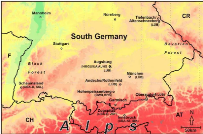
Fig. 1. Contour map with altitude indicated by different colours from green to red (up to about 3000 m a.s.l.) showing the positions
of the Bavarian Air Monitoring Network (L ¨UB) sampling sites
where daily PM10samples were investigated (see Sect. 3.3 also and
later in the text where the acronyms are used): Andechs/Rothenfeld
(ADRO), Augsburg (B¨urgermeister-Ulrich-Strasse) (AUB ¨U),
M¨unchen (Landshuter Allee) (M ¨ULA), Oberaudorf (Inn
val-ley motorway) (OBIA), Tiefenbach/Altenschneeberg (TBAL). Further sites include (see Table 1 also) Schauinsland (German Umweltbundesamt (UBA-D), SSL), Zugspitze/Schneefernerhaus (German Umweltbundesamt (UBA-D), ZSF), Hohenpeissenberg (Deutscher Wetterdienst (DWD), HPB), Innsbruck (Austrian Umweltbundesamt (UBA-AT), IBK) and Augsburg (Helmholtz Zentrum M¨unchen/University of Augsburg (HMGU/UA), AUHS).
3.1 Ground-based in situ measurements
An overview of the selected key monitoring sites, includ-ing their characterization and instrumentation, is given in Table 1.
measurement, Rupprecht and Patashnick, model 1400 a, East Greenbush, USA was used at AUHS and HPB.
PSD were recorded at AUHS, HPB, SSL and ZSF using electromobility spectrometers. These measurements are part of the German Ultrafine Aerosol Network (GUAN) that has been operational since 2008 at various sites in Germany (Bir-mili et al., 2009). At AUHS, a twin differential mobility particle sizer (TDMPS), IfT, Leipzig, Germany (detectable particle size range from 3 to 800 nm) is deployed in con-junction with an aerodynamic particle sizer (APS), TSI Inc., model 3321, Shoreview, USA (detectable particle size range from 0.8 to 10 µm). At HPB, SSL and ZSF scanning mobil-ity particle sizers (SMPS), TSI Inc., model 3936, Shoreview, USA are operated with a detectable size range from 10 to 800 nm (HPB, SSL) and from 10 to 600 nm (ZSF), respec-tively. At HPB, SSL and ZSF, a thermodenuder with 300◦C
(TD), TSI Inc., Shoreview, USA is running upstream of the electromobility spectrometers during each second sample to evaporate volatile PM components. Quality assurance pro-cedures at AUHS are documented in Pitz et al. (2008a, b), while Wiedensohler et al. (2010) is a reference for the qual-ity of the SMPS instruments deployed at HPB, SSL, and ZSF. Mannschreck et al. (2004) provides more information about the measurement program at HPB.
In addition, the in situ aerosol forward and backscatter-ing coefficient and Angstroem exponent were measured at SSL and HPB by a three wavelength integrating nephelome-ter, TSI Inc., model TSI 3563, Shoreview, USA. The total PNC was measured at ZSF with both a butanol-based and water-based condensation particle counter (CPC), TSI Inc., model 3025a, Shoreview, USA.
3.2 Remote sensing and air-borne instruments and data Although the majority of the collected data is based on in situ observations, we also analysed data sets provided by the following remote sensing systems:
– METEOSAT SEVIRI images from geostationary orbit (HPB).
– Ceilometer CL31 (backscatter profiles at 910 nm; Emeis and Sch¨afer, 2006) at AUHS (KIT/IMK-IFU), see Emeis et al. (2011) for further information about the ceilometer network of the DWD CEILONET as well as lidar measurements.
– Ultralight aircraft flight (KIT/IMK-IFU) in the late af-ternoon of 19 April in the area south-east of Augsburg, see also Emeis et al. (2011).
Since SEVIRI imagery is further used for discussing the syn-optic situation, the generation of these images and their phys-ical meaning is briefly explained. The detection of ash and dust in the atmosphere is possible by using infra-red satellite imagery based on red-green-blue (RGB) colour composites
(Schmetz et al., 2002) from the SEVIRI satellite radiome-ter. Due to the high spatial and temporal resolution of SE-VIRI, dust outbreaks, fire plumes and volcanic plumes can often be tracked and monitored for hours and even days. The European Organisation for the Exploitation of Meteoro-logical Satellites (EUMETSAT) provides the so-called “ash” and “dust” products at hourly resolution as RGB-images in a 5 day rolling archive (http://oiswww.eumetsat.int/IPPS/html/ MSG/RGB/). The RGB “ash product” is generated using the following SEVIRI channels (Ch) and channel combinations: red = radiance difference (Ch 12.0 µm – Ch 10.8 µm); this is the prime detection method for ash and dust in the atmosphere (also used for cloud detection);
green = radiance difference (Ch 10.8 µm – Ch 8.7 µm), partially sensitive to SO2;
blue = Ch 10.8 µm, cloud detection.
The flight of the ultralight aircraft was performed about 10 km north-west of the airport of Jesenwang (48◦10.46′,N, 11◦10.50′E, between M¨unchen and Augsburg) on 19 April leaving at 14:40 for a vertical profile up to 4000 m a.s.l. and returning to the ground at 16:30. This location was se-lected with the objective to compare the measurements with the remote sensing and in situ observations in the surround-ings. The instrumentation of the aircraft (Junkermann, 2001) includes an optical particle counter (OPC), Grimm, model 1.108, Ainring, Germany with 15 size bins between 300 nm and 20 µm, an open path nephelometer, HSS Inc., AVMIII, Bedford, Mass., USA for extinction measurements, and a seven-wavelength aethalometer, MAGEE Scientific, model AE42, Berkeley, USA for the spectral characterisation of the aerosol absorption. Also the ozone concentration, tempera-ture and dewpoint were detected. The additional CPC, TSI Inc., model 3010, Shoreview, USA was in operation only be-low 1200 m.
Daily PM10 samples from five stations of the Bavar-ian Air Monitoring Network (L ¨UB), which are shown in Fig. 1, have been chemically analysed for volcanic material. The sampling sites have the following char-acteristics: Andechs/Rothenfeld (ADRO): regional back-ground, Augsburg (B¨urgermeister-Ulrich-Strasse) (AUB ¨U): city background, M¨unchen (Landshuter Allee) (M ¨ULA): traffic, Oberaudorf (Inn valley motorway) (OBIA): traffic, Tiefenbach/Altenschneeberg (TBAL): regional background.
Samples were collected during 24 h on quartz fibre fil-ters (PALL TISSUQUARTZ 2500 QAO-UP, Lot 56276) by low volume samplers, Leckel, model SEQ47/50, Berlin, Ger-many. The elemental composition of the PM10samples from the five sites was analysed by ICP-MS after microwave de-composition of the samples as described in DIN EN 14902 (2005).
analysed for ions using suppressed ion chromatography with a Dionex AS14 column for anions and a Dionex CS12 col-umn for cations. The pH value is measured with a WTW pMX3000/pH meter and a Mettler Toledo InLab Science electrode, conductivity with a WTW LF3000 instrument and a WTW LR01/T electrode, both electrodes suited for low conductivities. The data are part of HPB’s routine contri-bution to the Global Atmospheric Watch (GAW) programme as a Global Station and are quality controlled according to the GAW procedures.
SO2 concentration was measured by UV-fluorescence method with Thermo Fisher Scientific Inc., model TE 43 CTL, Waltham, USA at HPB, SSL and ZSF, whereas at IBK monitoring site Horiba, model APSA 360, Kyoto, Japan was used.
4 Results of observations and interpretation 4.1 Synoptic Situation and transport of
volcanic emissions
On 14 April and 15 April, a North Atlantic high pressure sys-tem extended over the northern British Isles towards South-ern Scandinavia and induced north-easterly winds over Cen-tral Europe (for more details and affects in Iceland, see Pe-tersen, 2010). This favoured a rapid propagation of the volcanic plume across the North Sea to Germany and the Netherlands, as evidenced, e.g., by ceilometers that progres-sively detected the volcanic plume during its southbound motion at about 6–7 km a.s.l. (see Emeis et al., 2011). By 17 April, the centre of this high pressure system was located over Southern England and the main air flow continued from North-West to South-East. Since large parts of Central Eu-rope were cloud-free during 17 April and partially also on 18 April, the volcanic plume could be tracked by hourly ME-TEOSAT SEVIRI satellite imagery. Due to this tracking in space and time we are able to qualitatively distinguish the volcanic emissions from locally distributed dust in the study area. The Alpine area and large parts of south-western Ger-many and Switzerland were later affected by a low pressure system over the northern Adriatic Sea which brought clouds and rain showers to the area on 18 April and the follow-ing days, thus hamperfollow-ing observation of the volcanic plume by passive satellite instruments. This cyclonic system was mainly responsible for further dispersal of volcanic material in the area of interest.
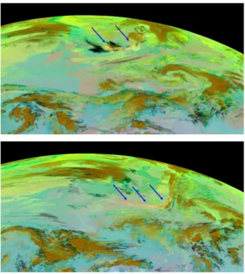
A first weak sign of the eruption became visible in SEVIRI data, the so-called “ash product” as described in Sect. 3.2, from 14 April, 08:00 UTC while clear signs were apparent by 15 April, 15:00 UTC. Observational conditions were not optimal for passive satellite instruments since high clouds hampered the view of lower atmospheric levels. However, on 16 April, 00:00 UTC, the ash front was clearly identified over the North Sea (Fig. 2, upper panel) in a distance of
al-Fig. 2. METEOSAT SEVIRI “ash product” from 16 April, 00:00 UTC (upper panel). The bow-shaped volcanic plume is appar-ent over the North Sea between England and Southern Scandinavia. The same type of image from 16 April, 18:00 UTC (lower panel) shows ash signatures over the Benelux area, Germany, Poland and the Czech Republic. Blue arrows indicate the position of the vol-canic plume which is colour-coded in orange.
ready about 1500 km from Iceland. The southern front of the volcanic plume was almost parallel to circles of latitude. Only nine hours later, the front line already passed the coastal zones of Germany and Poland and quickly moved across Germany. It further passed large parts of Poland, where the most southerly section of the front reached the Czech Re-public and Slovakia in the late afternoon of 16 April (Fig. 2, lower panel). At this point it is evident that the curvature of the ash front had grown, indicating a differential propagation by different sections of the volcanic plume. The area of high-est speed towards South-East is indicated by the right hand arrow in Fig. 2, lower panel. There, the ash plume is still vis-ible as a narrow, elongated plume moving south-eastwards with the main air flow.
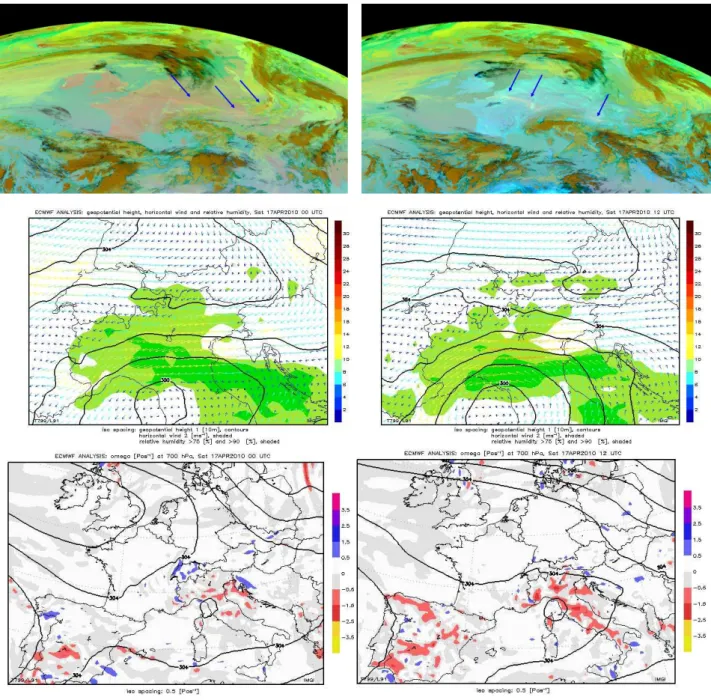
Fig. 3. Upper panels: METEOSAT SEVIRI “ash product” from 17 April, 00:00 UTC (left) and 17 April, 12:00 UTC (right). Blue arrows indicate the volcanic plume which is colour-coded in orange. High cloudiness (brownish) is apparent south of the Alps allocated to a cyclonic
system over the Gulf of Genoa. Middle panels: 700 hPa geopotential height (10 gpm contour lines), relative humidity (>90 % in dark green)
and horizontal wind (speed and direction, colour coded arrows in 2 m s−1steps) taken from ECMWF analyses. Lower panels: 700 hPa
geopotential height (40 gpm contour lines) and vertical wind components (colour coded in steps of 0.5 Pas−1).
in the relative humidity fields (Fig. 3, middle panels). The more rapid motion of parts of the plume towards South-East led to a more elongated front line across Europe (Fig. 3, up-per right panel). The most eastern part of the volcanic plume initially passed the eastern Alpine area, while the western patches were to later slow down over south-western Germany and in Switzerland on 18 April. As a consequence of this
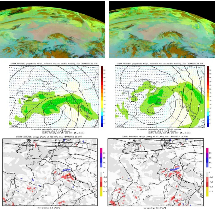
Fig. 4.Upper panels: METEOSAT SEVIRI “ash product” from 18 April, 00:00 UTC (left) and 18 April, 06:00 UTC (right). High cloudiness (brownish) is apparent south of the Alps allocated to a cyclonic system over the Gulf of Genoa (see also Fig. 3). Middle panels: 700 hPa
geopotential height (10 gpm contour lines), relative humidity (>90 % in dark green) and horizontal wind (speed and direction, colour coded
arrows in 2 m s−1steps) taken from ECMWF analyses. Lower panels: 700 hPa geopotential height (40 gpm contour lines) and vertical wind
components (colour coded in steps of 0.5 Pas−1).
Austria and Slovenia, but also over France (see arrows in Fig. 3, upper right panel). During 17 April, the low pressure system over northern Italy became more and more important for the spatial and temporal evolution of the volcanic plume north of the Alps. As seen in Fig. 3 (middle panels), the wind direction over the northern Alpine area turned from north-east to north-easterly directions. The southern Alpine area
Signatures of the volcanic plume are hardly visible in the satellite images from 18 April (Fig. 4, upper panels). This is due to the increasing influence of the low pressure system south of the Alps hampering the direct observation of the vol-canic plume over Tyrol and the northern Alpine area. The further approach of the cyclonic system induced southerly winds across the Alps contrasting the north-easterly winds the day before (Fig. 4, middle right panel). Some foehn-like impact on the air flow on 18 April (subsidence in the North of the Alps, blue areas in Fig. 4) is suggested by the banded structure of vertical velocity and short-term southerly winds at ZSH during noon. However, the foehn did not break through to e.g. the Inn valley bottom. However, the associ-ated cyclonic system rapidly crossed the Alps and lost con-trol over the air flow in the area of interest. The remaining volcanic material over the southern Benelux area and neigh-bouring France again moved slowly in a south-easterly di-rection, but satellite images largely lost track of the material due to cloudiness and the overall lower particle concentra-tions. A weak “ash” signature was found over France on 18 April (not shown) which was still present in the area on 19 April and moving to the South-East. Although observa-tional conditions over Germany improved again on 19 April, the ash load of the atmosphere was no longer visible from space. This was mainly due to stronger downward mixing to the ground and thus dilution, as it will be discussed later. Westerly winds dominated in the following days when ash remnants over Europe were no longer detected by passive satellite instruments.
ZSF detected the first enhanced SO2 and PM10 concen-trations on 17 April as the central Alpine station Jungfrau-joch (JFJ) in 3580 m a.s.l. also while JFJ registered the max-imum influences of the volcanic plume on 18 April (see Bukowiecki et al., 2011). This is in line with the satellite ob-servations. At that time (18 April), the volcanic plume was already mixed into the PBL over the northern Alpine area and Tyrol. Even weak precipitation observed on 18 April and 20 April in the northern Alpine area at ZSF and HPB did not completely wash out the particles (see e.g. Flentje et al., 2010). A second maximum of SO2and PM10concentrations was observed on 19 April at ZSF and JFJ also. An enhanced PNC was recorded at HPB until 22 April.
4.2 Spatio-temporal evolution of the volcanic plume Figure 5 shows the spatial distribution of daily PM10 concen-tration means in Germany for the time period from 17 April to 20 April. These maps were generated by UBA-D on the basis of their regional ground-based air quality monitoring network. The network does not include stations in the higher Alpine regions, so that the results of the interpolation for the Alpine region are affected by large uncertainties. For ex-ample the high daily PM10 concentrations on 17 April ob-served at SSL and ZSF are not visible on the UBA-D map for this day. The highest daily averaged PM10concentrations
of about 100 µg m−3were reached at measurement stations in the area of Stuttgart and Karlsruhe on 19 April and the max-imum regional daily average of about 60 µg m−3was deter-mined in the very south-western part of Baden-W¨urttemberg. On 20 April the daily averaged PM10 concentrations de-creased in that region but inde-creased in the area of Augsburg and M¨unchen up to maximum values of about 60 µg m−3.
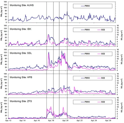
The PM10 and SO2concentrations at four core measure-ment stations IBK, SSL, HPB and ZSF peak at about the same time (17/18 April and 19/20 April, see Fig. 6). Only during the second episode (19/20 April) elevated PM10 con-centrations were observed at AUHS site (Fig. 6).
The highest short-term concentrations of PM10 of more than 140 µg m−3 were observed at SSL on 19 April. The PM10concentrations at ZSF were only half of the values ob-served at SSL, which is presumably due to the scavenging of coarse aerosols by precipitation. PM10 concentrations up to 100 µg m−3were measured in the city of Freiburg (ca. 10 km north-west of SSL and approximately 1000 m lower, see Fig. 5) and caused a threshold value exceedence there. Also, IBK reported PM10concentrations higher than 50 µg m−3for more than 12 h during both events indicating the presence of the volcanic plume at least 50 km south of ZSF. Note the Sup-plement documenting some details about the development across the Alps and the eastern regions of Austria. The influ-ence of the mountains upon the air mass transport is further discussed by Emeis et al. (2011). At HPB, PM10 concen-trations increased from 20 µg m−3to 40 µg m−3(peaks about 50 µg m−3)on 17 April and remained elevated until 23 April. These values are quantitatively in line with the results from JFJ (concentrations of PM10 around 30 µg m−3and SO2 al-most 4 µg m−3on 18 April as reported by Bukowiecki et al., 2011).
Apart from urban anthropogenic emissions, secondary ul-trafine particles (UFP – particle in the size range 3–100 nm) are regularly formed in the atmosphere during mid-day sec-ondary particle formation bursts (Kulmala et al., 2004). In Central Europe, such bursts seem to be triggered by the pho-tochemical formation of H2SO4, originating mainly from the oxidation of SO2(Birmili et al., 2003; Paasonen et al., 2010). Volcanoes are a major source of SO2 in the at-mosphere (see also Thomas and Prata, 2011). The Insti-tute of Earth Sciences of the University of Iceland pub-lishes current SO2 gas fluxes from volcanoes in Iceland (http://www.earthice.hi.is/page/IES-EY-CEMCOM). It is obvious from measured SO2 values (Fig. 6, maximum of 16 µg m−3 at SSL) that the volcanic plume contained SO
Fig. 5.Spatial distribution of daily mean PM10concentrations in Germany for the time period 17 April (upper panel left), 18 April (upper panel right), 19 April (lower panel left) and 20 April (lower panel right) on the basis of monitoring network data (German Umweltbundesamt – Federal Environment Agency of Germany, http://www.env-it.de/umweltbundesamt/luft-daten/index.html). The monitoring sites are indicated
by circles. Different concentration ranges in µg m−3are given by different colours as indicated in the maps. The network does not include
stations in higher Alpine regions, corresponding to the southern fringe of the map.
Central Europe on 17 April and 18 April which facilitate hy-droxyl (OH) radical production and their subsequent reaction with SO2(for more information about these processes, see Hamed et al., 2010; Kazil et al., 2010). Under non-volcanic conditions substantial contributions to secondary particle for-mation additionally stem from volatile organic compounds (VOC) as well as nitrogen oxides and ammonia as discussed by e.g. Kulmala et al. (2004). But during the volcanic plume
not strongly influenced by anthropogenic emissions. Thus, the SO2 levels are elevated during the two episodes at all measurement sites except Augsburg (Fig. 6). There are no SO2measurements available at AUHS, however, no increase of SO2concentration was observed at Augsburg monitoring sites operated by L ¨UB (data not shown). SO2concentration at ZSF rose sharply on 17 April between 08:00 and 12:00 from background levels up to 8 µg m−3, thus exceeding the maximum hourly concentrations observed between 2000 and 2007 in April (to be comparable to this volcanic plume event) as shown in Fig. 6.
Flentje et al. (2010) observed also high correlation be-tween the SO2levels and PNC of particles larger than 3 nm. It was especially pronounced at ZSF, whereas at HPB the clear signal of PNC was partially masked by enhanced an-thropogenic background. Time series of ultrafine PNC in the size range 10–30 nm and 30–100 nm observed at the four core measurement sites AUHS, SSL, HPB and ZSF in our study are shown in Fig. 7. On 17 April, ultrafine PNC lev-els rose from background concentrations to elevated levlev-els at ZSF shortly before 11:00 and two hours later at SSL. As discussed by Emeis et al. (2011), the delay at SSL is prob-ably due to the much lower height of this monitoring site (1200 m a.s.l. compared to the 2670 m a.s.l. of ZSF). The sig-nal peaks between 15:00 and 16:00 at both sites with a PNC of more than 16 000 and 12 000 particles cm−3at SSL and ZSF, respectively (size range 10–100 nm). During the fol-lowing hours, the measured ultrafine PNC decreased to a rel-atively low level of less than 4000 particles cm−3at SSL at 20:00, and later on also at ZSF. The latter PNC is rather typ-ical for ZSF if the station is within the PBL.
After reaching their first maximum, the ultrafine PNC de-creased on 18 April, but showed a second and stronger max-imum in the afternoon of 19 April. This peak occurred be-tween 12:00 and 13:00 at SSL, and four hours later (bebe-tween 16:00 and 18:00) at HPB and ZSF. The ultrafine PNC at AUHS showed a maximum between 13:00 and 14:00, but the association of this peak with volcanic material is par-tially masked by the elevated regional and urban background level in the urban air of Augsburg. The ultrafine PNC were higher during the second episode on 19 April than during the first episode on 17 April at all four locations AUHS, SSL, HPB and ZSF. Similar features were observed at Aus-trian sites measuring size discriminated particle concentra-tions (see Supplement).
The influence of volcanic ash on the time series of par-ticles in the size fraction from 100 to 800 nm is not visi-ble (data not shown). Obviously the effect of the volcanic eruption on particles in this size range (given there was one) was very small and it didn’t produce any prominent peak in PNC. This is in agreement with near-source (Ilyinskaya et al., 2011) and JFJ (Bukowiecki et al., 2011) observations during that time showing a bimodal distribution of the suspended aerosol mass with high particle abundances around 0.2 µm and at 1–4 µm.
Further in situ measurements at HPB are reported in de-tail by Flentje et al. (2010) and are briefly summarized here. There is no significant increase of PNC for particle sizes from 300 nm to 500 nm measured with an optical particle counter (OPC), Grimm, Ainring, Germany. The number of larger particles (300–1000 nm, 300–2000 nm, 300–4000 nm, 300– 5000 nm and 300–7500 nm) however increased significantly on 17 April. Local precipitation on 18 April and 20 April re-peatedly washed out particles (see Sect. 4.4.4 for analyses of wet deposition). The SO2concentrations at HPB were cor-respondingly high from 19 April to 21 April and peak values were about 25 % above the 99-percentile values from 2000 to 2007.
Comparison of particle samples recorded with and without TDs at SSL and ZSF between 14:00 and 16:00 on 17 April showed a considerable fraction of particles which consisted of evaporating material. This indicates the presence of evap-orable secondary aerosol which was initially not of volcanic origin but may have been formed in the volcanic plume from SO2. At the same time, elevated PNC were also found at the urban background site AUHS. Because of the much higher anthropogenic regional and urban background at this site, this maximum cannot be attributed to the volcanic plume (no enhanced SO2 concentrations, see Sect. 4.4.1). Note also that the increase of ultrafine PNC at HPB was much less pronounced in comparison with SSL or ZSF (see Sect. 4.4.3 too).
4.3 Measurements of trace elements to estimate PM10 mass enhancement caused by the volcanic plume The composition of daily PM10 samples collected by the L ¨UB was analysed from 18 April to 20 April. The aver-age increase of PM10 concentrations at all L ¨UB measure-ment sites (n=45) was 14 µg m−3from 18 April to 19 April and 8 µg m−3 from 19 April to 20 April. On 19 April, the threshold value for the daily average of PM10 concen-trations (50 µg m−3) was exceeded at 5 monitoring sites (two in M¨unchen (M ¨ULA and Stachus), two in Augsburg (K¨onigsplatz and AUB ¨U) and one in Kempten (about 100 km south-west from M¨unchen). On 20 April, exceedances of the threshold values were reported for 10 monitoring sites, mainly in M¨unchen (all 5 sites) and in Augsburg (all 3 sites). Also, Ansbach (about 40 km south-west from N¨urnberg) and N¨urnberg (both located in northern part of the L ¨UB) reported daily average PM10concentrations higher than the threshold value.
Fig. 6. Time series of PM10and SO2(hourly mean data) concentrations at the five core measurement sites Augsburg (AUHS), Innsbruck (IBK), Schauinsland (SSL), Hohenpeissenberg (HPB) and Zugspitze/Schneefernerhaus (ZSF) in the time period from 12 April to 27 April.
The two main entrainment events of the volcanic plume are shaded. Note that PM10 and SO2show a strongly correlated evolution at all
measurement sites.
metals scandium (Sc), vanadium (V), yttrium (Y) and zirco-nium (Zr) for the detection of volcanic plume influences at a background site in the Black Forest (about 14 km south of SSL, see Fig. 1). At this background site, a significant increase in the concentrations of all these elements was ob-served. Also, significantly increased concentrations of most elements named above on 19 April and 20 April were found. For example, in Fig. 8 the concentration of Ti at these sites during the time period from 14 April to 23 April is shown.
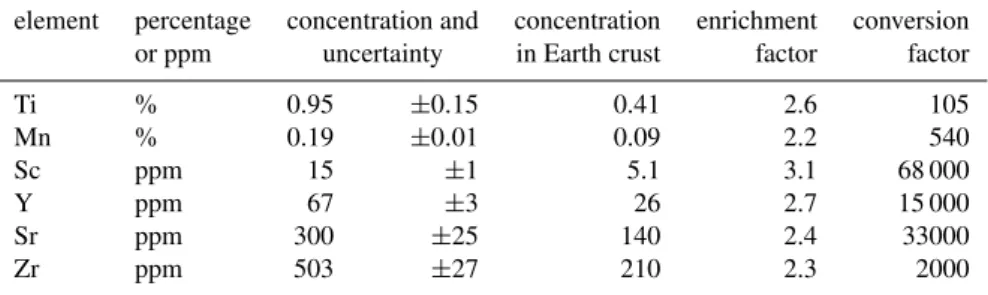
To estimate the contribution of volcanic plume material to PM10, it is basically possible to use elements with a signif-icant increase in PM10 and a high enrichment factor found in the ash samples. Some elements like Fe and Mn show however rather high background values due to the impact of anthropogenic sources (e.g. abrasion of braking pads, indus-try etc.) and are therefore less suitable for this purpose. The elemental composition of Eyjafjallaj¨okull ashes have been published on the website of the Institute of Earth Sciences of the University of Iceland (http://www.earthice.hi.is/page/ IES-EY-CEMCOM). Compared to the average composition of the Earth crustal material (Binder, 1999), the elements Mn, phosphorus (P), Sc, strontium (Sr), Ti, Y and Zr are enriched by a factor higher than 2 (see Table 2). The enrichment fac-tor is the ratio of average concentration in Eyjafjallaj¨okull ash and Earth crust. The exception is P, which was not
quan-tified in our samples. Therefore, apart from P these highly enriched elements were used to estimate the impact of the volcanic plume on PM10concentrations.
Fig. 7. Time series of ultrafine particle number concentration (PNC, hourly mean data) in two different size ranges at Augsburg (AUHS), Schauinsland (SSL), Hohenpeissenberg (HPB) and Zugspitze/Schneefernerhaus (ZSF) from 12 April to 27 April. The first maximum signal peak is on 17 April between 15:00 and 16:00 at SSL and ZSF (indicated by one vertical line) and the second one on 19 April between 12:00 and 13:00 at SSL and between 16:00 and 18:00 at HPB and ZSF (indicated by corresponding vertical lines). At AUHS, the maximum cannot be clearly attributed to volcanic origin because of the much higher anthropogenic regional and urban contributions to the concentration levels at this site.
Table 2. Part of elemental composition of Eyjafjallaj¨okull volcanic ashes (Institute of Earth Sciences of the University of Iceland (http: //www.earthice.hi.is/page/IES-EY-CEMCOM)) and Earth crust (Binder, 1999). The enrichment factor is the ratio of average concentration
in Eyjafjallaj¨okull ash and Earth crust. Only elements with enrichment factor>2 were used for estimation of volcanic plume contribution
to ambient PM and are given here. The conversion factor is the reciprocal value of the average concentration of the respective element in Eyjafjallaj¨okull ash.
element percentage concentration and concentration enrichment conversion
or ppm uncertainty in Earth crust factor factor
Ti % 0.95 ±0.15 0.41 2.6 105
Mn % 0.19 ±0.01 0.09 2.2 540
Sc ppm 15 ±1 5.1 3.1 68 000
Y ppm 67 ±3 26 2.7 15 000
Sr ppm 300 ±25 140 2.4 33000
Zr ppm 503 ±27 210 2.3 2000
(including SSL) and about 25 % in the city of Freiburg dur-ing the week 16–23 April were clearly of volcanic origin. Details about the spatial and temporal PM10patterns across Austria are given in the Supplement.
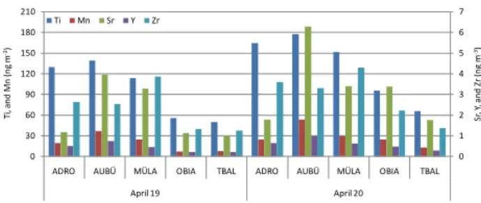
Using the known concentrations of Ti, Mn, Sr, Y and Zr of the Eyjafjallaj¨okull ash, the contribution of volcanic plume to ambient PM10 samples has been estimated by multiply-ing the surplus in concentration (Fig. 9) with correspond-ing conversion factors (see Table 2). On this basis, the im-pact of the volcanic plume to PM10 was 12±5 µg m−3 on 19 April and 17±7 µg m−3on 20 April (25±10 % on both
Fig. 8.Concentrations of Titanium in ambient PM10samples at five
L ¨UB sites (see Fig. 1 also: Andechs/Rothenfeld (ADRO), Augsburg
(B¨urgermeister-Ulrich-Strasse) (AUB ¨U), M¨unchen (Landshuter
Allee) (M ¨ULA), Oberaudorf (Inn valley motorway) (OBIA),
Tiefenbach/Altenschneeberg (TBAL)) from 14 April to 23 April.
This variation corresponds with the spatial distribution of PM10
concentrations on 19 April and 20 April as shown in Fig. 5.
On the other hand, the estimation of the volcanic plume contribution is supported by the fact that the fraction of both ammonium and nitrate in the PM10samples, which are also indicators for secondary aerosol, were substantially reduced during the volcanic plume events. Primary aerosol domi-nated those PM10 samples which are usually dominated by secondary aerosol. Further, only small changes of sulphate are observed, because part of it has probably been of vol-canic origin.
4.4 Additional measurements at the core monitoring sites
4.4.1 Evidence of volcanic plume influences in Augsburg (AUHS)
Within the PM10 record at AUHS (Fig. 6), peak concentra-tions were at least partially masked by the enhanced anthro-pogenic background. However, consideration of additional volcanic fingerprint data as described in Sect. 4.3 allows for an enhanced interpretation of the observed PM10time series and reveals a volcanic influence, too.
Also HYSPLIT backward trajectories (Draxler and Rolph, 2011) for AUHS were used for the days from 17 April to 20 April. These analyses confirm the former findings (Sect. 4.1) regarding the motion of the volcanic plume across Germany. At all levels, the trajectories consistently show an air flow from north-westerly directions on 17 April which caused effective transport of the volcanic plume to Southern Germany during this time. On 17 April and 18 April, the transport to Augsburg was from easterly directions but on 19 April and 20 April it turned to westerly directions, which is in line with the satellite observations and the surface wind analysis (see Figs. 3 and 4).
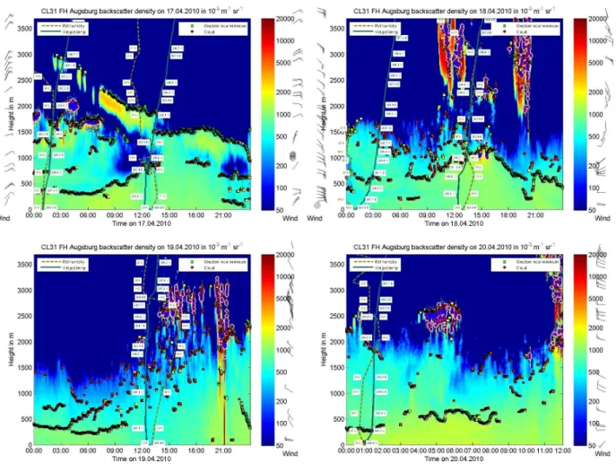
Ceilometer backscatter intensities at AUHS showed a layer of strongly enhanced backscatter above the PBL only on 17 April until 13:00 (see Fig. 10). From 02:00 until
0 1 2 3 4 5 6 7 0 30 60 90 120 150 180 210
ADRO AUBÜ MÜLA OBIA TBAL ADRO AUBÜ MÜLA OBIA TBAL April 19 April 20
Sr , Y , a nd Zr (ng m -3) Ti , a nd M n (ng m -3)
Ti Mn Sr Y Zr
Fig. 9. Surplus in concentration of the elements Ti, Mn,
Sr, Y, and Zr in ambient PM10 on 19 April and 20 April
over the average concentration in the reference period (14, 15,
16, 22 and 23 April) at five L ¨UB sites (see Fig. 1 also:
Andechs/Rothenfeld (ADRO), Augsburg
(B¨urgermeister-Ulrich-Strasse) (AUB ¨U), M¨unchen (Landshuter Allee) (M ¨ULA),
Oberau-dorf (Inn valley motorway) (OBIA), Tiefenbach/Altenschneeberg (TBAL)).
13:00, the volcanic plume subsided and was finally mixed into the PBL where its clear signature finally disappeared. From 17:00 until mid-night, a structured layer in the up-per part of the PBL became visible and is interpreted as a remnant of the formerly confined plume layer above a stable lower atmosphere. The ceilometer observations further indi-cate that there was a defined upper boundary of the PBL and the lower atmosphere was well mixed on 17 April from 13:00 until 17:00 up to about 1500 m a.g.l., i.e. the vertical exten-sion of the PBL was relatively large. Entrainment of vol-canic material into the PBL must be assumed in this phase, but a corresponding signal on the near-surface air composi-tion at Augsburg was not detectable due to strong dilucomposi-tion and high background concentrations. On 19 April, the situa-tion became different: Due to convecsitua-tion, the distinct separa-tion of the PBL and the free troposphere above disappeared. Flentje et al. (2010) reported thin plume layers all day on 19 April which could partly reach AUHS due to good vertical mixing and advection. During the following night, a stable near-surface layer and a residual second layer (Fig. 10) were formed. Such meteorological conditions favoured the enrich-ment of air pollutants at near-surface level, as seen during the night 19/20 April in Figs. 5 and 6.
Fig. 10. Observation results on 17 April (upper panel left), 18 April (upper panel right), 19 April (lower panel left) and 20 April from 00:00 to 12:00 (lower panel right) for ceilometer backscatter densities (colour coded) at Augsburg (AUHS). The computed height of the mixing layer is indicated by black dots in the lower panels. Additionally the results of the observations of the radiosonde from Oberschleissheim near M¨unchen at noon and midnight are shown: height profiles of wind, relative humidity and virtual potential temperature (values at the profiles).
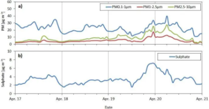
in the size range 1–2.5 µm is consistent with the increase of sulphate concentration in PM2.5(Fig. 11b). It is also in line with the only very small PNC increase of PM with sizes from 100 to 800 nm (see Sect. 4.2).
It is striking that an increased concentration of sulphate in PM2.5 occurred without a major SO2 peak during the vol-canic plume episode in Augsburg (see Sect. 4.2). It is also corroborated by a small increase of accumulation mode par-ticles. There can also be coating to the surface of existing fine and coarse particles with UFP (H2SO4)as discussed by Schumann et al. (2011) and Lettino et al. (2011). Further-more, as the travel time is about 3 days and H2SO4particles grow at about 6–7 nm h−1(Hamad et al., 2010) it seems pos-sible that H2SO4is a compound of particles with sizes be-tween 1 and 2.5 µm as is typical for sulphate (Fig. 11). Fur-ther dilution during transport down to the surface inhibited significant increases of SO2 concentration in the urban air
in Augsburg, whereas such an increase was observed at core monitoring sites at higher elevations. It can be concluded that H2SO4in UFP is formed much faster than the sulphate in accumulation mode particles.
Fig. 11. Time series of additional parameters (hourly mean data)
measured at Augsburg (AUHS) (17 April to 20 April) for(a)
par-ticle mass concentrations (PM0.1−1, PM1−2.5and PM2.5−10)and
(b)sulphate mass concentration in PM2.5. A volcanic plume
in-fluence is visible from the afternoon of 19 April until the morning of 20 April by significant increased concentrations of sulphate and
coarse particles (PM1−2.5and PM2.5−10).
4.4.2 Vertical profiles of parameters from ultralight aircraft flight
A flight by ultralight aircraft in the afternoon of 19 April co-incided with the arrival of a volcanic plume in the area. The ascent was performed in an aged air mass typical for a high pressure episode in the North Alpine forelands. The aircraft climbed above the shallow cumulus cloud layer present be-tween about 2800 and 3200 m a.g.l. (for more details, see Emeis et al., 2011) and stayed there for about 15 min. In the following descent, the characteristic features of the air mass significantly changed. The average ozone concentration in the lower 3000 m decreased from 140 to 95 µg m−3and the height of the maximum in the dewpoint profile indicating the upper rim of the mixing layer declined from about 1500 m down to 800 m a.g.l. In both profiles, the dewpoint above this local maximum steadily decreased with height, a fea-ture which in stagnant high pressure conditions is normally associated with cumulus clouds with a by far lower cloud base close to the maximum dewpoint. However, clouds were present at a greater height only. The change in the profiles is thus more likely due to a replacement of the air mass in the area beginning at about 3000 m a.g.l. and gradually progress-ing towards the ground where the new air mass was detected about one hour after the landing of the aircraft. Fine PNC and PSD did not change significantly between the aged air mass during the ascent and the volcanic plume influenced air mass of the descent but the optical properties were different. The spectral absorption in the UV was nearly completely sup-pressed while the absorption at 880 nm was comparable high in both profiles (see also Emeis et al., 2011). Concurrent with the reduction in UV absorption, a strong increase in the ex-tinction in the near infrared was observed, a clear indication of a different chemical composition of the air mass.
4.4.3 Fine particles at Zugspitze/Schneefernerhaus (ZSF)
To further characterize the ZSF time series, the total PNC measured by a CPC was analyzed. Especially at the begin-ning of the event with high PNC of very small aerosol parti-cles (10–30 nm size range, see Fig. 7) we observed a consid-erably higher signal of the water-based CPC. It is therefore likely that particles measured at that time were mainly wa-ter soluble, being in line with the aerosol measurements us-ing the TD channel. A possible source of such water-soluble aerosols would be the high SO2content which, after chemi-cal transformation, leads to sulphate-rich, water-soluble par-ticles (Hamed et al., 2010).
The scattering properties of aerosols were recorded by a three-wavelength nephelometer (450 nm, 550 nm, 700 nm). The retrieved ˚Angstr¨om exponents were mostly inverse to SO2concentrations indicating that parallel to high SO2 con-centrations high concon-centrations of particles larger than 1 µm size were transported to ZSF. Diverging from this find-ing, decreased aerosol scattering was already observed from 16 April, 12:00 onwards while the SO2 concentration did not increase until 17 April, 11:00. Precipitation starting on 18 April, 15:00 and on 20 April, 17:00 and 21:00, was likely responsible for increasing ˚Angstr¨om exponents, presumably due to scavenging of coarse aerosol particles. The SO2 con-centration levels however were not subject to reduction by precipitation because of the very low amount (0.04–0.07 mm on 18 April).
The entrainment of the volcanic plume into the PBL pro-ceeded from East to West due to predominant south-easterly winds for 24 h (see Figs. 3 and 4). After 18 April, 03:00, the wind changed first to western, then to northern direction and again to westerly directions. From 18 April, 08:00 onwards, easterly winds again dominated.
4.4.4 Composition of wet deposition at Hohenpeissenberg (HPB) and at Schauinsland (SSL)
On 18 April from about 12:00 to 14:00 and on 20 April from about 13:50 to 15:10 and with some breaks from 19:10 on-wards, it was slightly raining at HPB. Samples of these pre-cipitation events were analysed for water soluble ions (nitrate (NO3-N), sulphate (SO4-S), ammonium (NH4-N) and hydro-gen ion (H+)), elements (chlorine (Cl), Na, K, Mg and Ca),
acidity or basicity (pH) and conductivity. Table 3 shows the results for deposition (not pH). For reference, the table also includes the highest, mean and lowest depositions observed at HPB in April, during the ten preceding years.
Table 3.Ion depositions and conductivities in precipitation (wet deposition) at Hohenpeissenberg (HPB) and at Schauinsland (SSL).
Deposition
date cond. H+ Cl NO
3-N SO4-S Na NH4-N K Mg Ca
µS cm−1 mg m−2 mg m−2 mg m−2 mg m−2 mg m−2 mg m−2 mg m−2 mg m−2 mg m−2
HPB
April 2000–2009 max 85.8 0.653 12.7 27.0 14.0 6.3 44.2 1.4 1.3 7.2
April 2000–2009 mean 21.1 0.047 1.0 3.9 2.4 0.5 5.4 0.2 0.2 1.2
April 2000–2009 min 5.1 0.0001 0.008 0.060 0.026 0.002 0.098 0.016 0.005 0.012
18 April 2010 66.5 0.073 0.3 3.9 4.5 0.3 7.3 0.2 0.2 1.9
20 April 2010 32.0 0.004 0.7 4.7 3.1 0.3 7.8 0.2 0.2 1.6
SSL
April 2008–2009 max 42.0 0.60 5.5 3.8 7.9 3.8 20.5 1.4 1.2 5.0
April 2008–2009 mean 14.3 0.11 1.2 0.8 1.4 0.9 3.8 0.4 0.2 1.6
April 2008–2009 min 2.00 0.00044 0.18 0.05 0.05 0.104 0.15 0.04 0.03 0.16
20 April 2010 87.9 0.00021 0.7 5.3 3.7 0.8 7.7 0.9 0.2 1.6
in third place. The deposition data do not exceed the max-imum values measured in April during the ten preceding years. On 18 April, deposition of H+and sulphate was un-usually high, but both components were similarly high dur-ing the week before the eruption. These high depositions can therefore largely be attributed to the advection of polluted continental air in the PBL rather than to the volcanic plume on that day. On 20 April, the precipitation event was at the end of the volcanic influence upon the PBL. The same re-sults were found in May, when additional volcanic plumes were detected through high SO2 concentrations at ZSF. In summary, the wet deposition analysis results from HPB do not provide information about the volcanic influence on the air composition.
On 20 April at SSL only a minor amount of 0.4 mm pre-cipitation took effect in deposition. The depositions for SO4 -S, NO3-N, NH4-N as also for H+and Cl show quite similar values compared to HPB at that day (see Table 3). Although conductivity on 20 April showed the highest value compared to April 2008 and April 2009 it is not evident that the mea-sured depositions result from the volcanic plume influence. Thus the higher depositions at SSL can be attributable to the existing advection of polluted continental air in the PBL as at HPB.
5 Synthesis and discussion
5.1 Volcanic influences on air quality
Entrainment of volcanic plume material into the lower atmosphere was evident beginning from about the noon of 17 April due to the observed increase of PM10 and SO2 concentrations at the elevated observation sites ZSF (2670 m a.s.l.) and SSL (1200 m a.s.l.) as well as at IBK (570 m a.s.l.). As the PBL was well mixed on 17 April (Fig. 10), the volcanic plume reached the lower atmosphere in our study area in only a diluted form. A second event
ar-rived during the night from 17 April to 18 April with traces of additionally enhanced concentrations of PM10 and SO2 as measured at ZSF and IBK. The latter site is fairly repre-sentative for the conditions in the north-west regions of Aus-tria, while pronounced spatial gradients and time delays were observed towards the South and East reflecting specific to-pographic and meteorological effects (see Supplement). In Southern Germany, the associated meteorological conditions are characterised by a stable PBL up to 1500 m a.g.l., thus hampering effective down-mixing of the volcanic plume ma-terial to the surface.
During the afternoon of 19 April, another increase of PM10 and SO2 concentrations was measured at nearly all stations in Southern Germany and in the Innsbruck area with peaks around mid-night and a subsequent concentration decrease until the noon of 20 April. During this event, the meteo-rological conditions were more comfortable for downward mixing of the volcanic plume. The PBL extended up to about 2000 m a.g.l. during that time due to convective conditions favouring an entrainment of volcanic plume material into the PBL. The subsequent formation of a stable PBL with limited mixing near the ground during the evening of 19 April led to the additional accumulation of locally emitted particles.
Advection was also important. Between the second and third event the synoptic situation became different and the air flow changed from an easterly up to a westerly direction. That means that in the afternoon of 19 April, an exchange of air masses occurred in the northern Alpine region.
24 March to 25 March 2007 (Vanderstraeten et al., 2008) or Fe, Al, Ca, Ni and As from 27 May to 1 June 2008 (Bruck-mann et al., 2008) were found. But enhanced Ti concentra-tions as observed during the Eyjafjallaj¨okull volcano event were never seen in the long-term PM10 elemental analyses. A study for France by Colette et al. (2010) found the similar conclusions especially over 18 April and 19 April in Mul-house. The investigations by Bukowiecki et al. (2011) in Basel provided an average chemical composition of volcanic plume particles very similar to the trachyandesite-like com-position of rock samples collected near the volcano. Rossini et al. (2011) reported the analyses from atmospheric bulk deposition fluxes of total suspended particles (TSP) in Ri-mini, Italy, where sulphate, Al, Ca, Fe, Hg, K, Li, P, Si and Ti reached significantly high values in the period 19 April– 17 May 2010 which are 3 to 4 times higher than in the pe-riod 15 July–11 August 2010. In Southern Italy also (Tito Scalo) Littino et al. (2011) found in daily PM2.5 samples from 20 April 2010 on (maximum 22 April) enhanced Al, Ca, Fe, K, Mg, Mn, and Ti concentrations.
Those investigated sites (M ¨ULA, AUB ¨U) where the PM10 daily limit of 50 µg m−3 was exceeded due to the volcano plume impact were reported to the European Commission to be caused by natural sources (volcano plume). Conse-quently, the volcanic plume influenced the near-surface at-mosphere and thus the ambient air quality. However, the air pollutant emissions caused by the Eyjafjallaj¨okull volcano eruption were much lower than those estimated for the Laki eruption of 1783–1784. The PM10 and PM2.5 concentra-tions observed during the Saharan dust event from 27 May to 1 June 2008 at the monitoring stations used here were also higher (see Bruckmann et al., 2008) than during the Eyjafjal-laj¨okull volcano event but with different particle composition during both events.
For a second time after the April 2010 event, volcanic plume influences have been observed with a significant sig-nal at ZSF from 18 May, 09:00 to 19 May, 24:00. In con-trary to April, in May enhanced SO2concentrations were ob-served which exceeded 14 µg m−3on 18 May and 8 µg m−3 on 19 May. At the same time, precipitation at HPB was rel-atively clean and did not show any influence from the vol-cano. The observed SO2 concentration levels were clearly beyond the concentrations in April 2010. In contrast to the April event, frequent precipitation events and high rel-ative humidity occurred during the May episode, which con-siderably reduced PM10concentrations to maximum levels at about 20 µg m−3. Such enhanced SO
2together with PM10, PM2.5and sulphate concentrations were found by Revuelta et al. (2011) at the Iberian Peninsula in May 2010 also. During the May episode, various airports in Italy and again the airport at M¨unchen were nevertheless again closed for safety reasons. A discussion of further observational results together with modelling results can be found in Emeis et al. (2011), Miffre et al. (2011) and Heinold et al. (2011).
5.2 Possible health damages caused by air pollution originating from the volcanic plume
Ambient particulate matter has been a long standing con-cern to induce short-term as well as long-term health effects (Brunekreef and Holgate, 2002; Craig et al., 2008; Dock-ery, 2009). The size, shape and density of the particles de-termine their behaviour in the lung. As the human airways are the major surfaces of interaction, particles of sizes less than 10 µm entering the airways and of sizes less than 2.5 µm entering the lungs are of primary concern. This indicates that in principle, volcanic plume particles have the potential to affect human health. Indeed, reports from volcano out-breaks have demonstrated respiratory effects in study subject with underlying pulmonary disease (Longo et al., 2010; Gud-mundsson, 2011; Shimizi et al., 2007; Naumova et al., 2007). These observations seem highly plausible as high concentra-tions of particles have been indicated to irritate upper air-ways (Bascom et al., 1996; Peters et al., 1997; Tong et al., 2010). However, these respiratory disease exacerbations in association with acute volcanic particle exposure occurred at concentrations one to two orders of magnitude higher than in the investigated Eyjafjallaj¨okull event. Analyses of medi-cal surveillance data from the UK did not indicate an access of respiratory disease in association with regionally trans-ported particles from the Eyjafjallaj¨okull outbreak (Elliot et al., 2010).
The data presented in this paper indicates that the trans-ported mass of particles in populated areas was largely in the size range 2.5–10 µm. The control of anthropogenic particles focuses frequently on PM2.5(Craig et al., 2008). Consistent associations with cardiovascular diseases have been demon-strated in this lower size range (Brook et al., 2010). The strength of adverse health effects of the coarse mode parti-cles are still being debated (Brunekreef and Forsberg, 2005; Zanobetti and Schwartz, 2009; Tong et al., 2010). Regionally transported volcanic particles will mix with other particles from anthropogenic sources as well as may absorb compo-nents from the gas phase.
The transported volcanic plume particles may have poten-tially high acidity due to interaction with sulphur species. For example, H2S has been implicated as a biologically active species in relation to volcano outbreaks (Hansell and Op-penheimer, 2004). These compounds are expected as gases and/or within UFPs which are reaching the lungs. Epidemi-ologically, no relevant health effects for the population can be expected for the maximum daily average PM10 concen-trations (up to 100 µg m−3)and regional daily average PM
Nevertheless, it might be of interest to study the toxicolog-ical properties of the volcanic plume compounds after long-range transport. Toxicological investigations are underway to further elucidate the biological activity of particles col-lected during days with volcanic plume exposure. In con-clusion, there seems to be little evidence that the particles associated with the Eyjafjallaj¨okull outbreak have a dramat-ically increased toxicity. At the same time, it seems not to be warranted to assign to the transported volcanic particles the relatively low toxicity of non-anthropogenic influenced re-suspended dust particles (e.g. mineral dust).
6 Conclusions
On 17 April, enhanced PM10 and SO2concentrations were detected at mountain stations (ZSF and SSL) as well in Inns-bruck and other Austrian sites by in situ measurement de-vices. The air quality monitoring networks in Southern Ger-many (L ¨UB and LUBW) and ground-based in situ measure-ment systems at low elevations observed only a moderate in-crease of PM10 and SO2 during that time. However, peak concentrations of both PM10and SO2were detected by a lot of these stations and in Innsbruck on 19/20 April. On the basis of the chemical analyses of PM10samples (Ti concen-trations in PM10), the presence of the volcanic plume in the ambient air on 19/20 April can be shown.
From the beginning of 17 April, the ground-based in situ measurement systems at AUHS as well as of L ¨UB detected increased PM mass concentrations resulting in a peak in the early morning hours on 20 April which could be assigned to an increase of particles with diameters larger than 1 µm.
It can be finally concluded that on 19/20 April, the vol-canic plume was responsible for several PM10threshold ex-ceedances, thus being relevant for regional air quality. This event was supported by a specific development in the re-gional weather situation which otherwise prevented an in-fluence of the volcanic plume on air quality at monitoring stations on 17/18 April.
The particles attributed to the volcanic plume appeared either as UFP with diameters smaller than 100 nm, or pri-mary particles larger than 1 µm. It is concluded here that the high numbers of UFP at the beginning of the volcanic plume event were caused by photochemical processes acting in the SO2-rich regime of the volcanic plume. This chem-ical composition is a feature that distinguishes the volcanic plume from Saharan dust. Further, the enhanced concentra-tions of sulphate measured at AUHS and of H2SO4at HPB on 19/20 April (see Flentje et al., 2010) showed that SO2is transformed into these compounds during the transport of the volcanic plume. The high acidity of volcanic plume particles is a risk for human health in addition to the PM10 threshold exceedance.
Without further evidence from toxicological studies, we assume that the volcanic plume particles contribute to the
overall exposure of the population on 19/20 April and there-fore in principal may lead to exacerbation of respiratory and cardiovascular symptoms. However, for Germany the effect, if any, is expected to be minor.
Glossary
List of acronyms
a.g.l. above ground level a.s.l. above sea level
ADRO L ¨UB monitoring site Andechs/Rothenfeld APS aerodynamic particle sizer
AUB ¨U L ¨UB monitoring site Augsburg (B¨urgermeister-Ulrich-Strasse) AUHS measurement site Augsburg
CET Central European Time CPC condensation particle counter
DWD German Meteorological Service, Deutscher Wetterdienst GAW Global Atmospheric Watch program of the World Meteorological
Organisation
HMGU Helmholtz Zentrum M¨unchen, German Research Center for Envi-ronmental Health
HPB GAW-Global Station Hohenpeissenberg, Meteorological Obser-vatory
IBK UBA-AT monitoring site Innsbruck Zentrum, Fallmerayerstrasse IfT Leibniz Institute for Tropospheric Research
JFJ central Alpine station Jungfraujoch
KIT/IMK-IFU Karlsruhe Institute of Technology, Institute for Meteorology and Climate Research, Atmospheric Environmental Research LfU Bavarian Environment Agency
lidar light detection and ranging
L ¨UB Bavarian Air Monitoring Network of LfU
LUBW Air Monitoring Network of the Environmental Agency of Baden-W¨urttemberg
M ¨ULA L ¨UB monitoring site M¨unchen (Landshuter Allee) OBIA L ¨UB monitoring site Oberaudorf (Inn valley motorway) OPC optical particle counter
PBL planetary boundary layer PM particulate matter
PNC particle number concentrations PSD particle number size distributions SMPS scanning mobility particle sizer SSL UBA-D station Schauinsland
TBAL L ¨UB monitoring site Tiefenbach/Altenschneeberg TD thermodenuder with 300◦
C TDMPS twin differential mobility particle sizer TEOM tapered element oscillating microbalance UBA-AT Austrian Federal Environmental Agency (Austrian
Umweltbundesamt)
UBA-D German Federal Environmental Agency (German Umweltbundesamt)
UFP ultrafine particles: particle in the size range 3–100 nm UTC coordinated universal time
ZSF GAW-Global Station Zugspitze
Supplementary material related to this article is available online at:
http://www.atmos-chem-phys.net/11/8555/2011/ acp-11-8555-2011-supplement.pdf.
Acknowledgements. We like to thank our colleagues C. Jahn,
R. Friedl and M. Hoffmann (KIT/IMK-IFU) for effective
co-operation during the measurement campaign. Special thanks
to J. Kerkmann and K. Holmlund (EUMETSAT) for providing
the METEOSAT data that were used in this study. We thank
support of this work. Austrian air quality data were provided by A. Krismer (Tyrolean government) and W. Spangl (Austrian Umweltbundesamt, Vienna) which is gratefully acknowledged, too. We thank ZAMG (Vienna) for providing access to ECMWF data. Electromobility measurements in the German Ultrafine Aerosol Network (GUAN) were generously supported by the German Federal Environment Ministry (BMU) grant F&E 370343200. The authors acknowledge the NOAA Air Resources Laboratory (ARL) for the provision of the HYSPLIT transport and dispersion model and/or READY website (http://www.arl.noaa.gov/ready.php) used in this publication. R. Foreman (KIT/IMK-IFU) is grate-fully acknowledged the careful reading of the manuscript for grammatical correctness. We acknowledge support by Deutsche Forschungsgemeinschaft and Open Access Publishing Fund of KIT.
Edited by: K. Sch¨afer
References
Bascom, R., Bromberg, P. A., Costa, D. A., Devlin, R., Dockery, D. W., and Frampton, M. W.: Health effects of outdoor air pollution, Amer. J. Respir. Crit. Care Med., 153, 3–50, 1996.
BImSchV: Neununddreißigste Verordnung zur Durchf¨uhrung
des Bundes-Immissionsschutzgesetzes, Verordnung ¨uber
Luftqualit¨atsstandards und Emissionsh¨ochstmengen vom 2. Au-gust 2010 (BGBl. I S. 1065), Bundesministerium f¨ur Umwelt, Naturschutz und Reaktorsicherheit, Berlin, Germany, 2010. Binder, H. H.: Lexikon der chemischen Elemente, S. Hirzel Verlag,
Stuttgart, Germany, ISBN 978-3-7776-0736-8, 870 pp., 1999. Birmili, W., Berresheim, H., Plass-D¨ulmer, C., Elste, T.,
Gilge, S., Wiedensohler, A., and Uhrner, U.: The Hohen-peissenberg aerosol formation experiment (HAFEX): a long-term study including size-resolved aerosol, H2SO4, OH, and monoterpenes measurements, Atmos. Chem. Phys., 3, 361–376, doi:10.5194/acp-3-361-2003, 2003.
Birmili, W., Weinhold, K., Nordmann, S., Wiedensohler, A., Spindler, G., M¨uller, K., Herrmann, H., Gnauk, T., Pitz, M., Cyrys, J., Flentje, H., Nickel, C., Kuhlbusch, T.A.J. L¨oschau, G., Haase, D., Meinhardt, F., Schwerin, A., Ries, L., and Wirtz, K.: Atmospheric aerosol measurements in the German Ultrafine Aerosol Network (GUAN): Part 1 – soot and particle number size distributions, Gefahrst. Reinh. Luft, 69, 137–145, 2009. Brand, H. and Krafft, T.: The Icelandic ash cloud and other
erupt-ing health threats: what role for syndromic surveillance?, Eur. J. Public Health, 20(4), 367–368, doi:10.1093/eurpub/ckq088, 2010.
Brook, R. D., Rajagopalan, S., Pope III, C.A., Brook, J. R., Bhat-nagar, A., and Diez-Roux, A. V.: Particulate matter air pol-lution and cardiovascular disease: An update to the scientific statement from the American Heart Association, Circulation, 121(21), 2331–2378, 2010.
Bruckmann, P., Birmili, W., Straub, W., Pitz, M., Gladtke, D., Pf-effer, U., Hebbinghaus, H., Wurzler, S., and Olschewski, A.: An outbreak of Saharan dust causing high PM10 levels north of the Alps, Gefahrst. Reinh. Luft, 68(11/12), 490–498, 2008. Brunekreef, B. and Forsberg, B.: Epidemiological evidence of
ef-fects of coarse airborne particles on health, Eur. Respir. J., 26, 2, 309–318, 2005.
Brunekreef, B. and Holgate, S. T.: Air pollution and health, Lancet, 360(9341), 1233–1242, 2002.
Bukowiecki, N., Zieger, P., Weingartner, E., Jur´anyi, Z., Gy-sel, M., Neininger, B., Schneider, B., Hueglin, C., Ul-rich, A., Wichser, A., Henne, S., Brunner, D., Kaegi, R., Schwikowski, M., Tobler, L., Wienhold, F. G., Engel, I., Buch-mann, B., Peter, T., and Baltensperger, U.: Ground-based and airborne in-situ measurements of the Eyjafjallaj¨okull volcanic aerosol plume in Switzerland in spring 2010, Atmos. Chem. Phys. Discuss., 11, 12949–13002, doi:10.5194/acpd-11-12949-2011, 2011.
Colette, A., Favez, O., Meleux, F., Chlappini, L., Haeffe-lin, M., Morille, Y., Malherbe, L., Papin, A., Bessagnet, B., Menut, L., Leoz, E., and Rouil, L.: Assessing in near real time the impact of the April 2010 Eyjafjallaj¨okull ash plume on air quality, Atmos. Environ., 45(5), 1217–1221, doi:10.1016/j.atmosenv.2010.09.064, 2010.
Craig, L., Brook, J.R., Chiotti, Q., Croes, B., Gower, S., and Hedley, A.: Air pollution and public health: a guidance document for risk managers, J. Toxicol. Environ. Health A, 71(9–10), 588– 698, 2008.
Cyrys, J., Pitz, M., Heinrich, J., Wichmann, H. E., and Peters, A.: Spatial and temporal variation of aerosol number concentration in Augsburg, Germany, Sci. Total Environ., 401, 168–175, 2008. DIN EN 14902: Ambient air quality – Standard method for the
mea-surement of Pb, Cd, As and Ni in the PM10fraction of suspended
particulate matter, German version EN 14902, DIN German In-stitute for Standardization, Berlin, Germany, 2005.
Dockery, D.W.: Health effects of particulate air pollution, Ann. Epi-demiol., 19(4), 257–263, 2009.
Draxler, R. R. and Rolph, G. D.: HYSPLIT (HYbrid Single-Particle Lagrangian Integrated Trajectory) Model, National Oceanic and Atmospheric Administration (NOAA), United States Depart-ment of Commerce, Air Resources Laboratory, Silver Spring, MD, USA, http://ready.arl.noaa.gov/HYSPLIT.php, 2011. Elliot, A. J., Singh, N., Loveridge, P., Harcourt, S., Smith, S.,
Pnaiser, R., Kavanagh, K., Robertson, C., Ramsay, C. N., Mc-Menamin, J., Kibble, A., Murray, V., Ibbotson, S., Catchpole, M., McCloskey, B., and Smith, G.E.: Syndromic surveillance to assess the potential public health impact of the Icelandic vol-canic ash plume across the United Kingdom, April 2010, Euro Surveill., 15, 23, http://www.eurosurveillance.org/ViewArticle. aspx?ArticleId=19583, 2010.
Emeis, S. and Sch¨afer, K.: Remote sensing method to investi-gate boundary-layer structures relevant to air pollution, Bound. Lay. Meteorol., 121, 377–385, doi:10.1007/s10546-006-9068-2, 2006.
Emeis, S., Forkel, R., Junkermann, W., Sch¨afer, K., Flentje, H., Gilge, S., Fricke, W., Wiegner, M., Freudenthaler, V., Groß, S., Ries, L., Meinhardt, F., M¨unkel, C., Obleitner, F., and Suppan, P.: Measurement and simulation of the 16/17 April 2010 Eyjaf-jallaj¨okull volcanic ash layer dispersion in the northern Alpine region, Atmos. Chem. Phys., 11, 2689–2701, doi:10.5194/acp-11-2689-2011, 2011.