Vol-7, Special Issue-Number4-July, 2016, pp554-570 http://www.bipublication.com
Research Article
The etiology of the high-rise building construction spatial aspect in the
environment of the Iranian metropolises
(Case study: Pastor Tower in the Metropolis city of Hamedan)
Mohammad Rahmani*1, Zahra Nooshin2 and Elmira Rajabi3
Department of Urban Planning, College of Arts and Architecture, Hamedan Branch, Islamic Azad University, Hamedan, Iran
*1Corresponding Author Email: mohammad.rahmani1@gmail.com, z n 773@yahoo.com2, elmira_rajabi2020@yahoo.com3
ABSTRACT:
Nowadays, one of the most fundamental discussions regarding the urban planners and more importantly the researchers in fields such as geography and/or environment concentration is on the survey of the existing bottlenecks in the rapid and increasing growth of the population and traffic in the urban context which has been accompanied by the increase in the construction of high buildings and the outset of tower and skyscraper building as a symbol of development in the field of modern urbanization. What is of more importance in such an exhibition of power and the stultification with glamorous embodiments of high-rise building construction is the correct selection of the locus for building a tower based on the nature and the function the building is going to be served for and the spatial features of the region of the city context. The researcher, in a field study deals with the study of the skyscrapers’ construction in the city of Hamedan aiming at the identification of the damages and harms incurred on the urban bioenvironmental aspects even in a social ecological level and comes to this conclusion that the establishment place has not been studied precisely from the spatial and locus point of view through the analysis of the textural features of the place of the establishment for Pastor Tower in Hamedan and the volume and the capacity of the streets through a quantitative and statistical analysis, and it is in such a manner that the spatial system and the regional balance and equilibrium of the city has suffered some problems in various environmental, textural, social and bioenvironmental aspects.
Keywords: skyscraper construction, Pastor Tower, volume, capacity, service level, pollution
INTRODUCTION:
One of the phenomena in the face of the cities worldwide and particularly the large cities is the high-rise building construction. The high-rise building construction was first proposed with the purpose of exploiting the city center lands and upon focusing on the city economy. That was in response to the attitude that, from the one hand, tendency towards the density and centralization of the economical entities was the base of the intensified increase in the demands and request for the lands in the city centers and, from the other, the supply of lands in this region of the city was so limited. Thus, the increase in the buildings’
bioenvironmental pollutions, the reduction in the citizens’ access to fresh air and open spaces, light and the increase in the city disturbances. Through the increase in the urbanization and city-dwelling trend which is happening in the large cities and this has especially doubled during the recent century and, on the other hand, the possibility to make use of various and numerous activities which have been planned during the recent years in the skyscrapers and at the beginning of the new century more high-rise buildings will be built in the construction process of which there will be used and employed technical novelties including newer masonry and so forth. Among the articles presented in the high-rise buildings international conference which is held every year in a global level, it becomes clear that at the beginning of the 21st century that we are bearing witness to the construction of the skyscrapers a lot higher than the current high buildings and some of these buildings even appear as cities (Bemaniyan, 1998:56). In surveying the high buildings background in Iran it can be stated after the victory of the Islamic revolution until the early 1990s constructing high-rise buildings was stopped in the country and it was not until late 1999 that this trend was back at work again. This reconnaissance was mostly due to the internal and external wandering financial capitals which found its way to the high-rise building construction, of course in an unduly free and up-bouncing move and this was the reason that the experts deprived themselves of the opportunity to think and ponder over the issue and it was followed fiercely by the tower-users. The evolution of the cities during the course of history has been emanated from the technical mutations and the innovation of the modern communicational instruments. The novel urbanization activities turned the cities into highly vivacious and excited civil engineering centers but in the meantime they deprived the cities of the warmness, friendliness and amity which are needed by everyone. The limitations of the physical development, from the one hand, and the need to generate and build accommodations in a
large scale, on the other, made the construction of the high buildings necessary. High-rise building construction in a situation in which the price reduction resulting from thinking economically regarding land use is higher than the extra price coming from the highly elevated buildings construction, can be accounted for from the economical point of view. Glancing at the house building and high-rise building construction history, one can notice that in Iran the people’s life style has been mostly based on traditional methods up to the ruling era of Reza Khan. After Reza Khan’s coup, architecture which had kept in pace with the cultural-social movements was faced with no way other than acceptance of a new and unexpected move. The choice of a high building construction cannot be made based on the construct’s own behavior and practice such a selection may be more a function of factors related to the cultural, social, economical and technical issued (Hashemi, 1995:3).
One of the most important issues which is now being taken into consideration in urban geography management is at first the balanced spatial distribution and second the correct distribution of the land uses. Space is only a material product in respect to the other material factors. Among the other factors, we can point to the human being itself which grants the space a function, meaning and credit within the social relationships (Castells. 1977, 115).
situated within 360 Km southwest of Tehran and it is considered as the connecting chain which bridges the western part of the country to the center and it enjoys a unique spatial location with a lot of abundant natural, historical and cultural capacities which attracts the population coming from the peripheral villages and the west emigrants (Muhammadi, Baba’eepoor, Ezmiri, 2001, p.5,6). In the spatial and textural system of the city of the Hamedan the first phase of high-rise building construction can be observed after the outset of the imposed war with the objective of the collective accommodation of a group of fellow countrymen from the southwest of the country in Ayat Allah Kashani boulevard in the form of high building blocks, but the fact of the matter is that due to the lack of cultural grounding of this type of life style, about five years since the occurrence of such an incident the high-rise building construction phenomenon has had a low value standpoint in this city. And this continued until 1999 when the city vertical development venues had become very limited and the bank loans increase in number and size and the promotion of the land price we witness a rapid growth in high-rise building construction in Hamedan and since 2001 this trend has hastily been continuously increasing in speed. The various spaces in the city especially in the central core of the city were fast undergoing hurriedly unplanned evolutions and changes which resulted in variegated dimensions in the spatial and provisional system of the city of Hamedan.
The city of Hamedan from architectural perspective:
We are bearing witness in Hamedan, which dates back to before the Arians tribes immigration and it has a several thousand years of history in its background and has been the inheritor of the Iranian and Islamic thoughts and culture in the Iran’s country, to the great many of the landscapes exposed to the onlookers who have come to visit the city from all around the world and lost behind the high walls and buildings and the despondent dust of the modern life glory has covered their
visage. Unfortunately, consideration of the Iranian and Islamic architecture in city-building which was one of the distinct features of the geography of the cities located in Iran’s plateau has been substituted by the post-modern architecture. In the meantime, the city of Hamedan has started to move in a direction which is suggestive of the fading of many of the identity-reminding and balanced city-building system works and the emergence and appearance of the modern but incongruent architectural features which mostly are devoid of any sign of the Iran’s culture and history. Fialcov believes that “the city is the embodiment of the collective volition which is sometimes failed to be taken into consideration by the decision-makers (Fialcov, Yankel, 2009, p.52). So, this change which stems from the unduly and unbound development of the city life manages to combine the form, function and meaning in the urban spatial system with the construction of a volume of building masses and brings about disasters in the various environmental and urban spatial aspects which has been constantly pointed out by the thinkers and specialists from various fields.
The contemporary city-building in the city of Hamedan:
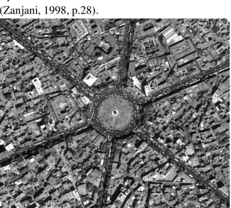
In 1928, a German engineer called Karl Freisch
prepared a map based on modern and
square circle has been initiated from the same data (Zanjani, 1998, p.28).
Illustration 1: the central plaza (the current Imam
Square) with a circle of the radius 80 meters and 6 streets
The geographical location of Pastor Tower:
The geographical position of the tower is between 34 degrees and 47 minutes to 23, 20" north longitude and 48 degrees and 30 minutes to 30, 05" latitude. And the elevation from the ground level is 67 meters which has been dug 8 meters in respect to the adjacent land.
The characteristics and the features of the Pastor Tower:
Regarding the tower design, the economical aspects have been closely taken into consideration to the maximum extent possible and the maximum space has been taken into use in designing the tower in 1993. The tower building has been constructed based on the article 19 and the
building has been constructed with the
approximate cost of about 260 billion Rials. According to Mr.Fathi, the executive investor of the tower accommodation and also Mr. Makan Hamedani, the general manager of Construction Company, Hamedan office, the tower does not imitate any plan from any other tower in the world.
The tower is privately owned and the individuals or companies are free to purchase units and flats in the tower building. Pastor Tower management has been assigned to the general board of
managers who are elected for three years through the general assembly elections.
The tower has been built in 13 floors, and the total
area under construction on a floor is
approximately 1005 meters. The most substantial usability of the tower is for business purposes and it incorporates 100 business units and 20 administrative offices and several sanitation and services units. Generally, there are 110 units and 20 stores in the tower and the entire floors in the tower are active and only the first floor which embraces a hall space for the citizens’ entrance is inactive and is not currently being used. Pastor Tower has been built in an eastern-western direction to take full advantage of the light from the sun and almost the entire array of the units receives natural light from outside.
The parking lot has been predicted on one of the floors with the maximum capacity of 17 automobiles.
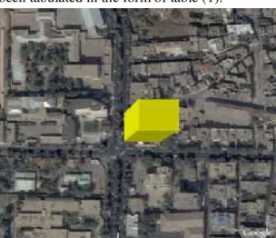
The spatial position of Pastor Tower:
Pastor tower, located on Pastor Street within 2 km from the Bu Ali Sina (Avicenna) tomb, contains an area of 1300 m land and 12 thousand meters area under construction. Between the tomb and the Pastor tower there are 3 main squares of the city. To put it simply, this huge project has been situated in the external wall of the city center and in the first ring of the city on the most important and the most luxurious business street or better said business mall in Hamedan which is of interest to a great majority of the people due to its enjoyment of the medical, sanitation and business services. The tower has been established on a street which has the capacity to be applied for the young people leisure time.
Illustration 2: the tower placement location along the line A-B
Bu Ali Sina tomb square which is located within 1 km from Pastor tower is the place the great Iranian scientists and physician Sheikh Al-Re’is Bu Ali Sina (AKA, Avicenna) has been engraved. Bu Ali tomb has been positioned in the middle of a square famous with the same name. it is an oval square with old sycamore trees, harmonic and symmetrical gardens, beautiful building and an sculpture which is an indicator of the square. This place is also being used for recreation activities and it shines like a bezel at the heart of this old
city. The important cities around the world are usually also famous for the existence of a memorial structure. It is for about 50 years that Hamedan, as well, has been designed and decorated with the Bu Ali tomb tower and also has ga=ined popularity for it (Fatemi, 2001, pp.71&72). In the following section the number of the tourists and the visitors visiting Bu Ali Sina’s tomb in the pointed square of interest spaces has been tabulated in the form of table (1).
Table 1: the number of the national and foreign visitors visiting Bu Ali Sina tomb in the time period from 2001 to
2006
Place 2001 2002 2003 2004 2005 2006
Bu Ali Sina Tomb 186280 355535 135889 115889 124982 274797
(Source: the organization of cultural heritage, handicrafts and tourism, Hamedan Province)
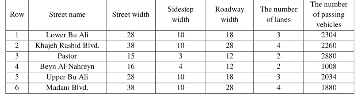
But, what seems to be of great value to be pointed out here is that besides the tourists who visit the internal space of Bu Ali Sina tomb square on a yearly basis and mostly during summer the square plays a traffic role for adjoining the lower Bu Ali Street to the Upper Bu Ali street. The researcher’s field studies indicate that on average 3960 individuals pass this square per hour and due to the recreational and leisure time aspects of the street for the younger generation more than 40% of the passing population cross the place two times. This number of the pedestrians with the large number of the automobiles crossing the area necessitates a control and monitoring by the police and it spontaneously increases the people’s communication with the police in a tangible manner in a way that there are 3 traffic police vehicles and 3 social police vehicles constantly present around the square and more than tens of walking and mobile police officers are performing their duties and of course this issue can be surveyed from various sociology aspects. In the survey which was mentioned above has been intended to embrace traffic and transportation area and parts of tourism and recreational aspects, but the square and the place where it is established possesses considerable points which should be referred to in the following parts. The square exterior radius tangents the peripheral sidesteps which is spatially is crawling with abundant traffic by the people who mostly come to the area for purposes such as performing their administrative works and/or daily purchase and in the following table the specifications of the streets pouring into the square and the number of the vehicles entering the square have been presented.
Table 2: the specifications of the streets opening to Bu Ali sina tomb square
Row Street name Street width Sidestep width
Roadway width
The number of lanes
The number of passing
vehicles
1 Lower Bu Ali 28 10 18 3 2304
2 Khajeh Rashid Blvd. 38 10 28 4 2260
3 Pastor 15 3 12 2 2880
4 Beyn Al-Nahreyn 16 4 12 2 1008
5 Upper Bu Ali 28 10 18 3 2034
6 Madani Blvd. 38 10 28 4 1880
(Source: Field observation)
Along the selected path, in the etiological survey and the identification of Pastor Tower in the city of Hamedan which has been evaluated along the lines A, B, A1and B2 it has been shown that on the one side of the lines segment there is Bu Ali Tomb square and on the other side there is Pastor Tower which leads to Shari’ati square and Jihad square. It appears necessary to study and survey the other side of this line segment that is Pastor Tower which is said to end in Shari’at square and Jihad square.
Pastor Juncture:
Pastor tower has been situated on a street which ends in a juncture and the tower has been located on the eastern length of the juncture and it is indicated by the segment line B and we try to investigate it from the spatial perspective. This juncture is located within one meter from the Pastor Tower which is one of the most important city areas from the perspective of traffic and the great many of the number of the walking pedestrians. Among the most important usages around the juncture we can refer to the following cases:
1. Pastor business Tower; 2. Delta business
block; 3. Clinic and hospital; 4. Qods Gym; 5. Education centers (schools, high schools and
pre-university); 6. Administrative, business and service uses.
With the above-mentioned uses being present around the juncture, to better get a clear view of the area we present the list of the names of the streets leading to the juncture and then we deal with positing some of the features.
1. Pastor St., 2. Sport St., 3. Mirzadeh Eshghi St.
(towards Shari’ati Square), 4. Mirzadeh Eshghi St. (towards Jihad Square)
The study and the survey of Pastor St. in the area between Tomb Square to Pastor Juncture and the tower of the interest has been also located on this street is a necessary issue and to more precisely figure out the other components there is no way out but to perform research and field studies.
Pastor Street features:This street is one of the places with a very high traffic in the city of Hamedan and it has an intermingled diversity of the various uses and the prevalence of the business spaces has turned this street to one of the mostly crowded streets. In the following, in table (3), the physical specifications of the street has been given and after a brief review we will deal with the comparison of the traffic volume and the existing capacities which has been accompanied by the
calculation of the street service level.
Table 3: Pastor Street physical specifications
Street name Street width Street length Sidewalk width Roadway width The number of lanes
Pastor 20 422 3 17 2
(Source: field observation)
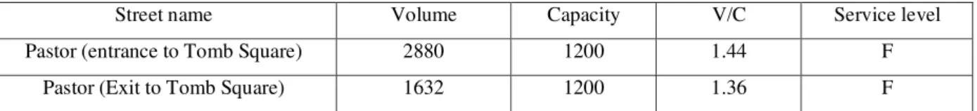
Pastor street imposes a heavy traffic load quite contrary to its local and business aspects and its use for spending the leisure time by the
(3) we deal with the comparison of the volume and the capacity and the service level, F, which is regarded as the least favorable service level in a
road network and this is suggestive of the critical issue we are coping with on this street.
Table 4: the comparison of Pastor Street traffic volume and the capacity and its service level, 2008
Street name Volume Capacity V/C Service level Pastor (entrance to Tomb Square) 2880 1200 1.44 F
Pastor (Exit to Tomb Square) 1632 1200 1.36 F (Source: field observation)
The evaluation of the service level which has been obtained via the comparison of the traffic volume and capacity is suggestive of the heavy vehicular traffic in this street and this can be per se studied from various view angles. In a survey study in 2008, 98% of the people working and residing in this area expressed their problems regarding the employment place and/or residence, the small width of the street and the heavy vehicular traffic and the aforementioned calculations are other
evidences documenting the problem. The street suffers from a heavy load of passing vehicles both in its entrance and exit to and from the Tomb Square and the studies indicate that over 40% of the vehicles moving in and out in this direction are single-passenger ones. This high volume of traffic along with the density of the various usages presented in table (5) is per se reflective of the need for in-depth analysis and pondering of the problem.
Table 5: the number of the existing uses on Pastor Street and its percentage in 2008
St. name
Business uses
Administrative uses
Tourism uses
Service uses
Residential uses
Cultural uses
Medical uses
Educational uses
No uses
Pastor 142 17 6 5 23 7 6 4 9
Percent 64.8 7.76 2.73 2.28 10.5 3.19 2.73 1.82 4.10 (Source: field observation)
What is clear from the extant uses field observations is the understanding of the idea that the highest usage percent goes to the business and then residential uses and the important which should be taken into consideration here is that more than 70% of the existing business usages on this street have been located inside the Pastor Twer. Therefore, it can be said that the business uses are predominant on the street and also there are other considerable uses such as service, tourism, and medical one all of which on this single street and that along a path lower than half of a kilometer. All of these various uses with their vast number of visitors and referents have been centralized along one single street and consider what negative consequences can be happening from the of textural, spatial, social and
level on which a 67-meter tower has been established.
Table 6: the number of the stops and the manner of the vehicles stops in 2008
Street Taxi station Bus stop Parked cars Double-parked cars Tel. Kiosks No parking signs
Pastor 2 2 140 3 3 6
(Source: field observation)
Of the information extracted from table it can be well perceived that the number of the cars parked along the Pastor St. has exacerbated the environment’s roadway space situation along with the heavy load of the vehicular moving on the street in such a manner that if we consider 6 meters as the parking space, with the calculation of the space in the front and at the back of the cars while parking, it can be readily comprehended that along the path of the street there is no place for any other car parking and also the lack of a public parking lot is another disaster in adding to the
problem which can be questioned as a need to be taken into consideration, but the damages imposed on the street’s texture cannot be only pursued in the vehicles moving on the street and the traffic jams they cause; rather, in between, the pedestrians’ traffic volume and the movement of the people’s masses who are present there for the purposes mentioned previously, and this has made visible the contacts and impacts between walkers and riders. In table (7), the number of the
vehicular and automobile and walking
pedestrians’ traffic has been investigated.
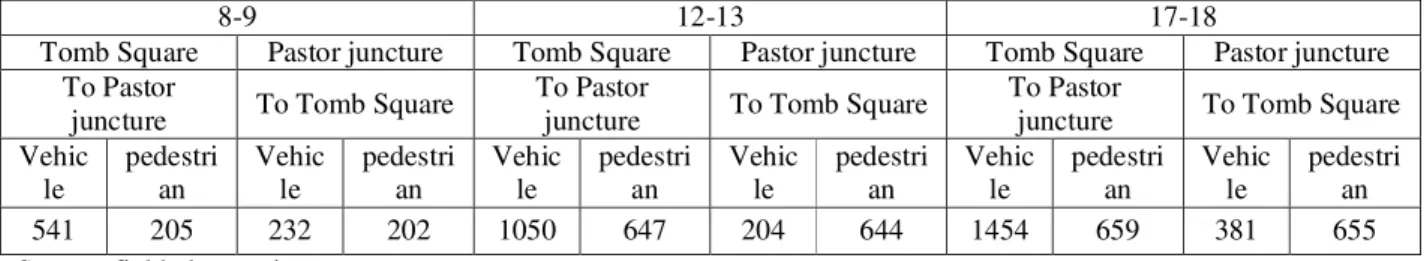
Table 7: automobiles-pedestrians’ traffic volume mean on pastor street during three days of the week and at three
peak traffic in 2008
8-9 12-13 17-18
Tomb Square Pastor juncture Tomb Square Pastor juncture Tomb Square Pastor juncture To Pastor
juncture To Tomb Square
To Pastor
juncture To Tomb Square
To Pastor
juncture To Tomb Square Vehic
le
pedestri an
Vehic le
pedestri an
Vehic le
pedestri an
Vehic le
pedestri an
Vehic le
pedestri an
Vehic le
pedestri an 541 205 232 202 1050 647 204 644 1454 659 381 655 Source: field observation
What is obtained from the information presented in the above table is the number of high traffic volume and the intertwined nature of the vehicular and pedestrians movements which reaches to its peak during the afternoon hours and this is while in the survey study performed here it became evident that out of 10% of the street inhabitants 27.5% use their own personal cars, 38.8% use taxis and the rest of the neighborhood people take buses, motorcycles and/or passenger car agencies to satisfy their daily needs outside their homes. In the analysis of the information extracted from the tables it is clear that during all hours of the comings and goings of the vehicles and the
pedestrians to and from the street, the automobiles’ traffic to and from the street is 1.5 to 2 times the pedestrians and this is an issue that can be considered from many aspects that on a path that its services are within a 10-minitue period from the city center for every pedestrian there are two cars entering the environment and this city section space and only during the ending hours of the observation which has been 17-18 the number of the walking pedestrians and that on their way back increases in comparison to the number of the cars and this also can be studied from other viewpoints regarding the movement of the pedestrians and cars to and fro.
Table 8: pedestrians traffic volume mean on Pastor Street (in peak hours), in 2008
Pedestrians peak traffic hours 8-9 12-13 17-18
Woman 139 490 918
Man 266 799 590
Total 405 1289 1508
But what was reminded of as the most critical issue was the change in the traffic type in the afternoon hours and this made the researcher investigate this change of behavior which happens in a collective manner in the society and for the same purpose the researcher dealt with the study of the gender combination of the walking pedestrians during various hours and it became accordingly revealed that during 8-9 in the morning 66% of the pedestrians on Pastor St. are majorly men and remaining 34.3% are women. And this is indicative of the high percent of the men employment in respect to women because it is considered as the hour for the employees to start traveling towards their work environments. In the current research it was found at various hours during the day the men’s traffic is about 1.5 to 2 times the women’s traffic but abruptly at about 17-18 this trend reverses and the number of women exceeds that of the men and according to the social conditions and the limitations existing in the society for the women and it is considered as the women turning back hour to their houses the number of the women pedestrians becomes 1.5 times the men and this increase of the women respective to the pedestrians’ volume in contrast to the men and the increase in the total number of pedestrians in sharp contrast to the other hours of the day is the main reason behind the increase in the number of pedestrians in contrast to the number of the cars, but such an increase is an indicator of a change in the social area and the elimination of some of the limitations for the women in the community level and the studies regarding the understanding the subtle realities of the issue indicated that 70% of the people choosing this street for movement are youths and 15% are the adolescents who refer to the street with the purpose of recreation and spending their leisure time and the remaining part is consisted of the adults and the children who come to the location with purposes such as clinics and treatment centers, but the point that should be thought over here is that the contacts and the
impacts between the youngsters has turned this place to a locus for the occurrence of some of the social incidents and sometimes even social offences and crimes and, from the one hand, the volume of the vehicular traffic and the large number of the walking pedestrians and the small width of the sidewalks (3 meters) makes the movements in both sides of the entrance to the street within a 100-meter radius interlaced by the pedestrians and vehicles along with one another and this has resulted in traffic jams at this point and this intersect and also has caused the intra-city travelling time and the waiting time increase in spite of the existing path being very short.
Mirzadeh Eshghi Street:
To survey and study Mirzadeh Eshghi St., as one of the adjacent street to Pastor Street from the point of view of the existing uses, the physical specifications and the number of the vehicular traffic should be taken into consideration on this path in the area between Pastor Juncture to Shari’ati Square towards Jihad Square each in separate considerations. Thus, to do so, the street’s physical specifications have been given in table (9).
What is indicated by the field observations is the non-identical traffic volume on Mirzadeh Eshghi during various times such as the hours, day or various days of the week or the various months of the year which is indicative of tangible fluctuations.
Table 9: Mirzadeh Eshghi physical specifications in 2008
Street name St. width St. length Sidestep width
Roadway width
The number of lanes Mirzadeh Eshghi St. (from Pastor juncture towards
Shari’ati square) 17 520 3 14 2
Mirzadeh Eshghi St. (from Pastor juncture towards
Jihad square) 20 616.0 3 17 2
Source: field observation
Table 10: the survey of the volume, capacity and service level on Mirzadeh Eshghi Street, Hamedan, 2008
Street name Volume (v) Capacity (c) V/C Service level Mirzadeh Eshghi St. (Shari’ati square entrance) 351 1200 0.29 A Mirzadeh Eshghi St. (Shari’ati square exit) 425 1200 0.35 A Mirzadeh Eshghi St. (Jihad square entrance) 786 1200 0.65 D Mirzadeh Eshghi St. (Jihad square exit) 1900 1200 1.58 F Source: field observation
The survey indicated this important theme that the street enjoys a heavy vehicular traffic, mostly single-passenger, both in the entrance to Shari’ati Square and in the entrance to Jihad Square and due to the various business, educational and administrative uses a heavy load is imposed and through the comparison of the volume and
capacity and according to the physical
specifications of the street we come to service levels which indicate that on Mirzadeh Eshghi, entrance and exit to Shari’ati square, the traffic is flowing freely and the traffic volume and its density are very low and in Shari’ati square entrance where the vehicles speed is waxing and waning of a uniform and balanced state and increases and decreases based on the situation this
can be pointed out that the traffic service level is doing the least acceptable quality and as for Mirzadeh Eshghi service level on the exit section to Jihad square according to the physical specifications and the better situation in comparison to the above-cited street it has to be stated that the vehicles speed is very low and sometimes the traffic loses its freedom of movement and maneuvering becomes very limited as a result of high volume of the traffic. After a short survey regarding the volume, capacity and the service level of the street we, in the following section, deal with the various uses existing on the street which are introduced in table (11).
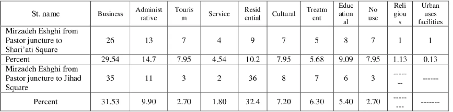
Table 11: uses existing on Mirzadeh Eshghi St. in 2008
St. name Business Administ rative
Touris
m Service
Resid
ential Cultural
Treatm ent
Educ ation al
No use
Reli giou s
Urban uses facilities
Mirzadeh Eshghi from Pastor juncture to Shari’ati Square
26 13 7 4 9 7 5 8 7 1 1
Percent 29.54 14.7 7.95 4.54 10.2 7.95 5.68 9.09 7.95 1.13 0.13 Mirzadeh Eshghi from
Pastor juncture to Jihad Square
35 11 3 2 36 8 7 6 3
--- ---
Percent 31.53 9.90 2.70 1.80 32.4 7.20 6.30 5.40 2.70
--- ---
Source: field observation
And from the above table and the survey of the available usability cases on the street it becomes clear that the majority of the extant uses on the street belong to the business uses and then
mostly residing the street or work on the street park their personal cars along the street in such a manner that the conducted field survey signifies that the parked cars are there for a longer period of time but in places where no parking signs have been installed we are observing a low number of employees and residents cars parked and considering the situation and the descriptions made regarding the current status of the street in referring to the existing centers on the street the citizens have no other way than violating the
traffic regulations and sometimes they are forced to double park along the aforementioned path and such violations have no outcome but the increase in the traffic jams and the slow flowing of the vehicles movement and the occurrence of likely accidents resulting in damages and losses. In table (12) we have dealt with the survey of the both of the entrance and exit to the street from the perspective of the automobiles and pedestrians traffic volume to get a better view of the walkers and riders movement style.
Table 12: the number of the vehicles and pedestrians traffic during three different hours and on three different days on
Mirzadeh Eshghi St., in 2008
8-9 12-13 17-18
Shari’ati Square Jihad Square Shari’ati Square Jihad Square Shari’ati Square Jihad Square To Pastor
juncture
To Pastor juncture
To Pastor juncture
To Pastor juncture
To Pastor juncture
To Pastor juncture Vehic
le
Pedestri an
Vehic le
Pedestri an
Vehic le
Pedestri an
Vehic le
Pedestri an
Vehic le
Pedestri an
Vehic le
Pedestri an 320 363 265 340 1050 647 204 644 1454 659 381 655
Source: field observation
From the information presented in the above table it becomes clear that it is the high number of pedestrians and the vehicular traffic volume which reaches to its peak in the afternoons. Although among the existing uses on Mirzadeh Eshghi it is business and administrative uses which have the highest percentage but it seems that the majority of the vehicular and pedestrian traffic is for the purpose of taking advantage of the clinic and educational centers which are 9.09% and 5.68%, respectively, of the total percentage of the uses. In field observations which were conducted on the street what is more visible is the high number of the vehicular traffic which is moving in the direction from Jihad Square, Zendan turn towards Pastor Street. Such a study shows that on Jihad Square path towards Pastor Juncture the number of the pedestrians exceeds that of the vehicles at hours from 17 to 18 and it is only in the ending
hours that the number of the vehicles increases in respect to the number of pedestrians.
In this street, as well, at the ending hours the number of the women pedestrians increase respective to the men and this situation continues almost till 19 and from 19 on the number of women pedestrians follows a descending trend respective to men.
Another adjacent street to Pastor Tower is Sport Street.
Sport Street: among Pastor Tower adjacent streets this street enjoys a sort of traffic isolation for both the walkers and the riders along its approximately 245-meter long path and it becomes more active and accepts more traffic when holding a sport event.In table (13) the physical specifications of the street has been given and after the survey of which we deal with the traffic volume comparisons and the existing capacities which should be assessed along with the service level.
Table 13: Sport Street physical specifications
Street name Street width Street length Sidewalk width Roadway width The number of lanes
Sport 30 245 5 25 2
As it was mentioned this street also enjoys a high vehicular and pedestrian traffic during certain days and hours. The existing uses on the street are rare abut important. The street has important uses such as Qods sport stadium, Girl pre-university
center and also the physical education
organization’s general office has been
continuously under the focus and during the days and hours in which football matches are held for reasons such as prevention from traffic jam the street from Pastor Juncture to Setareh avenue are closed by the law enforcement agents and no vehicular traffic is performed in this area. The stadium has a capacity to incorporate more than 4000 people and it is not located in an appropriate place from the spatial point of views, since, firstly it is situated in the city center and, secondly, the traffic in the peripheral radius of the street due to
the severe concentration of the uses mentioned before is not very easy and facilitated. The stadium is equipped with private parking to accommodate the employees’ personal cars but the cars which are consecutively parked along the street can be viewed clearly and according to the statistics obtained from the field studies 0.90% of the cars parked belong to the stadium itself. But, anyhow, the street is prevalently enjoying a traffic comfort and through the survey of the physical specifications of the street along with the volume and capacity comparisons we come to a service level of A which is regarded as the most favorable service level in automobile traffic in a road network and the survey results pertaining to the computations relate to volume and capacity of the street have been given in table (14).
Table 14: volume, capacity and service
level on Sport Street, in 2008
Street name Volume (v) Capacity (c) V/C Service level Sport (entrance to Pastor Juncture) 20 1200 0.01 A Sport (entrance to Setareh Street) 14 1200 0.01 A Source: field observation
While traffic status is very light and tranquil on the street but in the field observation conducted in 2008, the street’s adjacency to Mirzadeh Eshghi and Pastor Juncture has made 0.95% of the people working or living in this area to complain about the locations acoustic pollution and the congestion and the crowdedness of the football match observers in Qods stadium and 0.98% of the His Highness Ameneh high school and pre-university students have asserted that they are not satisfied with the current situation of the place and when in some occasions the schools closing time coincides with the finishing whistle of a match it is said that this is the most troublesome hour for the school students.
CONCLUSION AND SUGGESTIONS:
What is needed to be more scrutinized to get a full image of the spatial problems of the street is the situation of Bu Ali Tomb Square as a focal
collecting and distributing point for the
transportation and traffic in the spatial radius of a path which is the focus of the researchers and the surveyors from the perspective of tower establishment etiology in the city of Hamedan and it can be of great help for better understanding and more realistic perception of the issue and the lack of a thorough strategy and policy in the selection of tower establishment locus.
For the same purpose, in the comparison of the capacity and the volume and the service level of the streets opening to this square both in the entrance and exit the obtained results indicate that the service level is D which is suggestive of the heavy traffic.
heavy traffic load regarding both the pedestrians and vehicles passing ways.
The situation of the area of interest in the city of Hamedan that is the distance between Tomb Square and Pastor Juncture with variegated uses such as business, administrative, residential, educational, treatment and so forth which includes 142 business units, 17 administrative units, 23 residential units, 11 educational and cultural units, 6 clinical units, 5 service units and 9 inactive units and it has been turned into a dynamic and active stream in guiding the city population into this space. In the following to recognize the etiological problems stemming from the Tower in that location which has been built to serve several use cases it is worth pointing to the idea that the accidents and the traffic reasons in this area which are per se of concerns as other damages in this neighborhood are generally a consequent of lack of observing the precedence rights and keeping a clearance from the front automobile and wait times, dullness and high intensity of the traffic volume are among the reasons behind such accidents which usually have material and life damages and losses, but, fortunately, due to the slowness of the movements and the low speed life losses have not been experiences in the area and it has been said that the most common traffic jams and long waiting hours are during the summer and mostly in August, however, in the other days and months of the year during the weeks and at peak hours especially during afternoon hours and from the sunset on the situation gets worse by reasons such as population congestion, non-observation of the traffic engineering principles, lack of existing multi-floor parking lots, the narrow streets and the lack of resorting to the traffic regulations by both the pedestrians and the drivers and these all add a considerable part to the problem.
Such an extra volume imposed on the passages capacities and streets with heavy load of traffic and the heavy weight of the Tower and the use cases in a very cramped area entails numerous studies and scrutiny and further research on the
detection of establishment places for the high buildings.
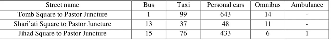
Based on the researches performed by the environment organization, 33.6 kg carbon dioxide is produced from the use of 14 liters gas and deductively it can be said that 2488.968 kg carbon dioxide is produced along this path in an hour of vehicular traffic and the studies have shown that in Hamedan the most underlying factor behind pollution is the vehicular traffics. And based on the studies conducted in a bioenvironmental and treatment research center more than 90% of the pulmonary and breathing difficulties and diseases and 0.20% of the cardiovascular disease result from air pollution and according to the researches undertaken by Canadian researchers the mortality rate originating from air pollution is 4 times the AIDS and air pollution is detrimental to human life 14 times the water pollution and 16 times the food poisoning and pollution. Air as the most essential material for the continuation of human and animal lives and every human consumes 16 kg oxygen and 1 kg food on average. The human beings can last sometimes up to 5 days but without air it cannot live even for five minutes. Based on the field studies in 2008, only in one hour and that be between 17 to 18, 1508 pedestrians enter the area under study from four different points and this is while the researches by the scientists have proved that an old vehicle consumes an amount of oxygen equivalent to the extent that can be used by 200 individuals in moving a 1-km distance within 24 hours and as it was mentioned previously the existing sources indicate that 70% of the air pollution in the city of Tehran is generated by the vehicles and for the same reason we are to point out that of the total number of the automobiles moving to and from this space more than 10% are old and out-of-date vehicles which are being dealt with in greater details in the sections to come.
observations that 29.2% of the buses which are coming and going to and from the study space and adjacent to Pastor Tower are old and out-of-date and produce pollution to a large scale and in between 16.3% of the taxis are of the same features and the same studies indicate that 0.7% of the personal cars are among the old and
out-of-date automobiles. However, the specific
conditions of the street and the location which is among the luxurious recreational and modern places in the city of Hamedan has caused the entrance of lesser number of old cars to the area
but the high volume of the traffic, density and the high number of the movements to and from this place with even this small percentage of the old cars and the amount of the carbon dioxide and other pollutants generated is in itself an evidence of the lack of precise study of the place of establishment for the construction of Pastor Tower in the city of Hamedan. In the following section and in table (15), the total number of the old and out-of-date automobiles entering the study area has been presented.
Table 15: the number of the old automobiles in Pastor Tower peripheral space
Street name Bus Taxi Personal cars Omnibus Ambulance Tomb Square to Pastor Juncture 1 99 643 14 - Shari’ati Square to Pastor Juncture 13 37 48 11 - Jihad Square to Pastor Juncture 15 76 433 6 1 Source: field observation, 2008
Hamedan as the shining and green bezel of the history and civilization of civil life in Iran is nowadays one of the cities which has suffered the largest damages from the establishment of various and numerous towers which are devoid of necessary studies regarding the detection of a proper placement location. The surveys indicate that till the end of 2007, Hamedan Municipality has issued permit for the construction of 10 towers without exact spatial studies in the context of the city and without taking their status in adaptation with the environment and compliance with the important principle of adjacency and the other physical aspects of the city space into consideration and this in itself has brought about conditions such as contrast, density, air pollution and so forth in a limited space but full of congestion and population. Precision in the order, balance, symmetry for the creation of a larger extent of unity between the elements and the component of the urban life space is an unavoidable issue in a city which is the underlying issue in land use planning and it has been described by Dr.Razawian as “the proper and on-time use of the land and finally land preparation measures required for the achievement of the future objectives” (Razawian, 2002, no.114) and
50 db for the study area, particularly in Pastor Street.
The results of the present study indicates the lack of a comprehensive and exact scrutiny of the placemen before the tower construction in the city of Hamedan regarding the form, function and the semantic in urban spaces that means that the surface and the visage which is exhibited by the combination and blending of the various buildings displaces an image of masses of buildings which are amalgamated with the height, and an array of the other surrounding and constraining bodies and other factors and it can be courageously said that Pastor Street spatial system composition does not show the expected balance, symmetry and proportion with Pastor Tower and the street specifications, as well. In the survey of the spaces the features such as dynamic and stationary nature of the place should be taken into consideration and the proportion should be granted to the place through placement of other elements.
Proportion is obtained by the relationship between various aspects existing in a space or a thing, and among important issues of the type one can point to the proportion between spatial width and length of the buildings.
Different width to length ratios creates various
sensations for the observers and the users of the streets. If this ratio is set equal to the street
is found to be very open and wide and if the length is given a higher value respective to the
width in the form of and/or the
streets look very narrowed and confined and this creates a sort of tedium in the onlookers and bystanders (Shirani, 2007:45). In the survey of the placement of Pastor Tower the ratio has been more than and definitely it can be seen that one
of the most substantial issues and problems is the feeling of depression, indolence and anguish with this sort of calculations of Pastor Tower specifications.
Scale is the relationship between the size of a space or an object with the other related objects in such a manner that if the size of a space can be of a good relationship with the human body then it is said that the space is of a human scale and the surveys performed indicate that the study area lack such a scale.
In many of the cities the organizational methods are being used to preserve the market texture liveliness and to keep the central core of the city, one such methods is the separation between the city business center via a freeway from the other parts of the city and in order for the cars to be able to have access to the city business center large parking lots can be created by the freeway around the marketplace in a large scale. The method of preventing cars from entering the business center area can be effective in short-run but for longer terms this method cannot be accountable, but the creation of high buildings or towers with business uses, zoning and regional segregations for controlling and directing the uses can be of great help. In zoning there should be regulations and rules which are actively enforced and in which the length, volume, position, size, the occupancy level have been clearly determined and this, in fact, is a new policy the objective of which is to give order to the construction of the buildings and it encourages the establishment of buildings in a very favorable manner. In the survey of such a structure through the determination of the population rate and the type of the activity in every urban region the type of the uses with specified volume and scale determines the city spatial capacity.
this is what has not been taken into consideration on Pastor Street regarding the construction of Pastor Tower and there is a need for some sort of coordination between the buildings from the perspective of height and density and the buildings should be built with the identical height and density or there is a need for predicting sufficient space between the buildings. Of course, in determining the elevation and height of the buildings in city building there are various methods one of the most important of which is the Gabari method or the light-prevention angel. Based on this method, not a single section of the high buildings should intercept any building segment border lined horizontally in angels of 45° or 63.5°.
In zoning and due to the particular emphasis made by the researcher on the pre-construction survey of the placement locality of any tower or building in a city the following comments should be taken into consideration: 1. Reduction of pollution in the streets; 2. Safeguarding safety against fires and other risks and dangers; 3. Enhancing public welfare and health; 4. Supplying sufficient light and air; 5. Preventing from highly dense building constructions; 6. Preventing from population over concentration; 7. Considerations regarding the establishment of facilities from the perspective of sufficient provision of transportation, water, sewage, schools, parks and the other public requirements and needs.
The locality identification standpoint or the urban localities organization is the determinant factor for social activities in the context of a city. So, among the most important points which should be taken into consideration in making tower in the city of Hamedan is planning a space with a city scale in which the provision of a competent textural environment qualified of healthy civil life is the primary objective and in such a planning the textural planning is the physical aspect of the social-economical planning. Therefore, the city maps should be elucidated according to the social, economical and environmental objectives and standards (Sa’eednya, 1998, p. 53). So, it can be
said that the city is consisted of a series of human activities which takes a general system format whole and this is comprised of components such as human, activities, land and space (Daneshpoor et al, 1994) and disregarding such elements does not allow one to solely pay attention to the urban context and the buildings’ physical conditions, the studies undertaken by the researcher of the current article indicate that the great number of the population, massive locations and asymmetrical spaces diminishes comfort and tranquility for the citizens in the urban environments.
in the number of the cars or the city streets rather the problem is more due to the reasons such as insisting and urging the creation of massive and substantial administrative, business, cultural and clinical centers on the first ring of the city and in its vicinity.
REFERENCES:
1. Bemanyan, Muhammad Reza. (1998). “factors
effective on the formation of high buildings in
Iran”. PhD dissertation, architecture
engineering department, Tehran University
2. Hashemi, Seyyed Reza. (1995). “the history of
high buildings”. The journal of Abadi, no.18,fall, pp.3-11
3. Muhammadi, M., Baba’eepoor,M., Ezmiri, N.,
(2001). “natural attractions of Hamedan Province”. issue no.1, Miras Farhangi
4. Fialcov, Yankel. (2009). “urban community”.
Tr. Abd Al-Hussein Nik Gowhar, no.2, Agah, p.168
5. Zanjani, Habib Allah. (1998). “Iran in the
course of history:” the journal of Abadi, no. 28, spring, pp. 3-13
6. Fatemi, Seyyed Abu Al-Hassan. (2001).
“Hamedan Province tourism image”. Amir,
Hamedan, Iranian and Global Tourism
organization publications, p.202
7. Qarrehnejad, Hassan. (2006). “an introduction
to the industrial geography and transportation”. Isfahan, University Jihad, no.7, p.176
8. Sa’eednya, Ahmad. (1998). “urban planning
studies”. V.1, no.1, Tehran, the country’s
municipalities and rural governorships
organization, p.53
9. Daneshpoor, Z., Ansarinya, S., (1994). “the
principles and the fundamentals of the urban planning”, no. 1, tehran, Shahid Beheshti university publication, p.336
10.Razawyan, Muhammad, Taqi. (2002). “urban
land uses”, 1st ed., tehran, Monshi, p.255
11.Cultural heritage, handicrafts and tourism
organization of the province. (2006).
12.Shirani, Hussein. (2007). “location
organization”. 2nd ed., Tehran, Azarakhsh,
p.256
13.CASTELL (1977) THE URBAN QUESTIAN :
EDWARD ARNOLD
14.CHAPIN,F STUART AND KAISER ,
EDWARD ,(1979) URBAN LAND USE PLANNING ILLINOIS UNIVERSITY
15.SAYER/ANDREW (1978) THE DIFFERNCE