http://istgeorelint.uoradea.ro/Reviste/Anale/anale.htm
THE VULNERABILITY OF THE TERRITORIAL-ADMINISTRATIVE UNITS
TO THE HYDROLOGICAL PHENOMENA OF RISK (FLASH FLOODS).
CASE STUDY: THE SUBCARPATHIAN SECTOR OF BUZĂU CATCHMENT
Remus PRĂVĂLIE∗∗∗∗
Master Degree in Hydrology and Climatology, Faculty of Geography, University of Bucharest, Romania, e-mail: [email protected]
Romulus COSTACHE
Master Degree in Hydrology and Climatology, Faculty of Geography, University of Bucharest, Romania, e-mail: [email protected]
Abstract: The present study aims to analyze, on the one hand, the flash-floods forming potential in the Subcarpathian sector of Buzău catchment, an area with high susceptibility to hydrological hazards such as flash-floods, and, on the other hand, the vulnerability of the territorial-administrative units to these risk phenomena. Thus, in the first stage, the Flash floods Susceptibility Index (FFSI) index was defined for the Subcarpathian sector of Buzău catchment, based on environmental factors with a relatively static nature, considered causal factors in the flash-flood phenomena genesis. The next stage of this work was the delimitation of the vulnerability index of the territorial-administrative units, based on the highest FFSI index values which correspond to the built surfaces from the analyzed units. The results showed that more than 80% of the territorial-administrative units are exposed to flood phenomena, while almst 20% is currently under serious risk of damage in case of hydrological risk phenomena occurrence.
Key-words: surface runoff, flash-floods, vulnerability, risk
INTRODUCTION
In the special literature, flash-floods and floods are considered extreme phenomena with high potential for economic and social damage (Sorocovschi 2002, 2003). Although the risk phenomena such as flash-flood have a short spatiotemporal occurrence (they are generally affecting areas below 1000 km² and the duration is less than 6 hours), these are one of the most calamitous natural disasters categories with the most severe environmental and social consequences (Villarini et al., 2010). In Europe, in most cases, indirect calamitous effects, like floods, were generated by flash-floods in almost half of the cases that have been recorded during 1950-2006 (Barredo, 2007). The main causes that led to the enhancement of these phenomena, especially in the last century, are linked to the global climate change (Huntington, 2006), and to the changes in the land use in the affected areas (Marchi et al., 2010). Given the intensification of these extreme phenomena, it is necessary to know the social vulnerability, a vulnerability class which is among the most studied in the specialized approaches (Ruin et al., 2009), due to the very expensive damage. The study aims to assess the vulnerability of (built) artificial surfaces from the Subcarpathian sector of Buzău catchment, based on their intersection to areas with high flash-floods potential.
METHODOLOGY
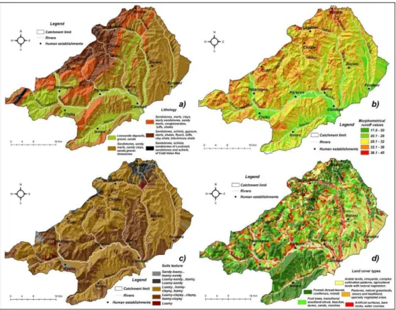
The Subcarpathian sector of Buzău catchment currently shows a high potential for runoff formation. Flash-foods are a direct consequence of this phenomenon. This happens, in the most cases, due to the lack of hydrotechnical flood facilities for flash-flood attenuation. The study area is one of the few subcarpathian areas that lack this type of facilities. Thereby, in order to estimate the slope surfaces with high potential for runoff and flash-floods, the Flash floods Susceptibility Index (FFSI) was created, an index used for similar studies in the subcarpathian areas with high potential for flash-floods occurrence (Prăvălie & Costache, 2013). For the present study, the index was obtained by using the GIS environment (ArcGis 9.3), in Stereo 70 projection, by integrating four stationary factors, with a major role in flash-floods genesis: geology, the morphometric factor, pedology (soil texture) and land cover (figure 1).
Figure 1. Spatial representation of lithology (a) morphometric factor (b), soil texture (c) and land cover (d) in the Subcarpathian sector of Buzău river basin.
The morphometric factor integrates several factors such as: the slope, the profile curvature, the hydrological network convergence and others. This factor is rigorously analyzed in a specialized study (Costache & Prăvălie, 2013), based on a numerical terrain model and taken as a factor with a major role in analyzing the flash-flood potential in the present study.
These four factors were spatially modeled at 10 m cell size. The spatial modelling of the lithology was possible due to the Romanian geological map, at a scale of 1:200 000, while the soil texture was obtained from the pedologycal map, at a scale of 1:200 000 and the land cover was obtained from Corine Land Cover 2006 database (European Environment Agency).
the final steps of the integration and delimitation of the FFSI. In the case of the lithology, the bonitation scores were given after relative assessments regarding the permeability of the rocks, according to available specialized sources (Scrădeanu & Gheorghe, 2007, p. 151). Also, the bonitation scoring was performed according to the soil texture after the proposed methodology by Matreață & Mătreață (2010) and Teodor & Mătreață (2011).
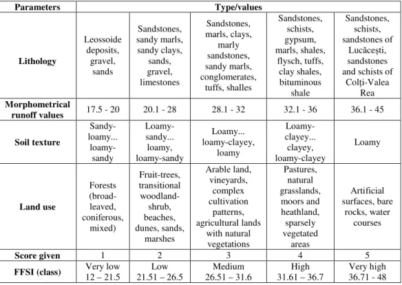
Tabel 1. Classification and indexing of the physical-geographical and anthropogenic factors in order to obtain the FFSI susceptibility index in the Subcarpathian sector of Buzău river basin
Parameters Type/values
Lithology Leossoide deposits, gravel, sands Sandstones, sandy marls, sandy clays, sands, gravel, limestones Sandstones, marls, clays, marly sandstones, sandy marls, conglomerates, tuffs, shalles Sandstones, schists, gypsum, marls, shales, flysch, tuffs, clay shales, bituminous shale Sandstones, schists, sandstones of
Lucăcești, sandstones and schists of
Colți-Valea Rea Morphometrical
runoff values 17.5 - 20 20.1 - 28 28.1 - 32 32.1 - 36 36.1 - 45
Soil texture Sandy-loamy... loamy-sandy Loamy-sandy... loamy, loamy-sandy Loamy... loamy-clayey, loamy Loamy-clayey... clayey, loamy-clayey Loamy Land use Forests (broad-leaved, coniferous, mixed) Fruit-trees, transitional woodland-shrub, beaches, dunes, sands, marshes Arable land, vineyards, complex cultivation patterns, agricultural lands with natural vegetations Pastures, natural grasslands, moors and heathland, sparsely vegetated areas Artificial surfaces, bare rocks, water courses
Score given 1 2 3 4 5
FFSI (class) Very low 12 – 21.5
Low 21.51 – 26.5
Medium 26.51 – 31.6
High 31.61 – 36.7
Very high 36.71 - 48
The second stage of this study consists in extracting the built surfaces from the administrative-territorial units based on Corine Land Cover database. In this study, the built surfaces were considered the most important socio-economical elements of risk in case of natural disasters such as floods. The intersection of the surfaces with the highest potential for flash-floods (corresponding 36.71 - 48 values) and the built surfaces represent the last stage of the study. Depending on the affected area the Flash-Floods Vulnerability Index, was defined at the level of administrative units, which is the percent ratio between the potential affected area and the total built-up area, at the level of each territorial-administrative unit.
RESULTS AND DISCUSSIONS
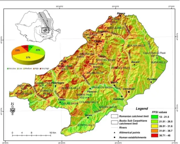
Figure 2. Spatial representation of FFSI index values in the Subcarpathian sector of Buzău river basin
According to the standard deviation, the index values were grouped into five classes each one expressing the occurrence (more intense or less intense) of the runoff process (table 1).
Thus, the first class of values, designating areas with a very low runoff potential is between 12 - 21.5 and occupies about 7% of the study area. These areas occur in forested areas of Ciolanu and IstriŃei ridges, and also in Nișcov, Cislău, Pătârlagele and Pârscov depressions characterized by a low gradient and that overlap on a substrate characterized by a high potential for water infiltration. The values of the second class, between 21.51 – 26.5, mean a low potential for runoff occurrence, and represent a half pound of the study area. This low runoff potential corresponds to hilly forested units from the southern and eastern subcarpathian sector of Buzău catchment and also from the valley of the main river in the study area.
The medium runoff potential is almost equally distributed in the study area, specific values between 26.51-19.6 representing 38% of the total area. Values between 31.61 – 22.8 of FFSI have a high share, of over 23%, and correspond to areas with a high potential for runoff manifestation. These are the hilly areas of Blidișelu, Dâlma, Bisoca, Pripor, Cornetului, located in the northern part of the study area, close to the mountain area. These areas are characterized by a slope of 15 ° and a low degree of afforestation.
The fifth class of values has the highest interest, indicating a high potential for flash-floods occurrence and for flooding inhabited areas. Specific slopes of these areas exceed 25º, these being totally deforested slopes. Thus, values above 36.71 occupy 8% of the Subcarpathian sector of Buzău catchment.
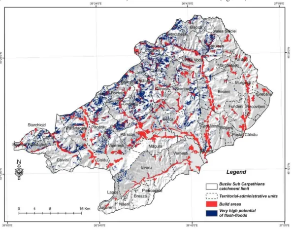
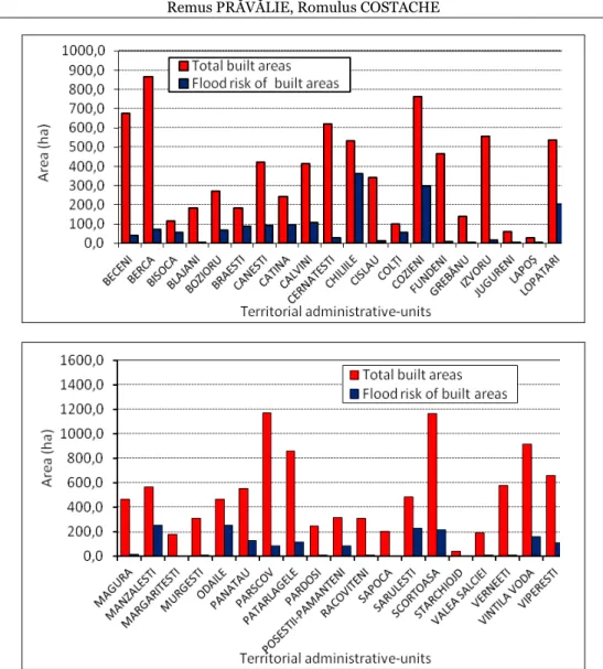
In order to see the built-up areas from the administrative-territorial units exposure degree, by using GIS, the layer of the fifth class of values was intersected with the built surfaces layer (obtained from the Corine Land Cover data) from each administrative unit (figure 3).
Figure 3. Spatially modelling the areas with very high potential for flash-floods and the built areas in order to obtain the vulnerability index at the territorial administrative unit level.
By overlaying the surfaces with the highest values of FFSI index (36.71 - 48 class) with the built areas at the level of administrative-territorial units (figure 3), the Flash-Floods Vulnerability Index (FFVI) was obtained and expressed as percentage values (figure 5).
As vulnerability involves the notion of resilience (the capacity to adapt to variations in environmental disturbance) (Blaike et al., 1994), in developing the FFVI index preventive measures of hydrological hazards such as flash-floods were taken into account. In the study area, the most important measures are dams in river beds, which are present in short river bed sections on the right part of towns like Săpoca, Berca and Pârscov, so prevention effects are minimal.
According to the values, the FFVI index was grouped in five classes of values (figure 5), depending on the intersection between built surfaces and the areas corresponding to the FFSI index fifth class of values, which is the class values corresponding to the highest flood potential due to high flash-floods susceptibility (figure 4).
Figure 4. Total built surface values (ha) and those with high risk of flooding due to flash-floods, at the level of territorial administrative-units
The second class of FFVI, designating the areas with a low vulnerability, include surfaces affected by a high potential for runoff (and thus for flash-floods genesis), and represent between 10-20%. This is the case of the administrative-territorial units such as Starchiojd, Pătârlagele, Vintilă Vodă, Viperești and Scorțoasa (figure 5).
Figure 5. Spatial representation of FFVI index values in the Subcarpathian sector of Buzău river basin
CONCLUSIONS
We believe that the present methodology is very useful for finding measures to avoid possible crisis situations generated by hydric risk phenomena. In the Subcarpathian sector of Buzău catchment, the highest index values proposed for the evaluation of runoff process (FFSI) are recorded in the internal hilly area, at the contact with the Carpathian area, where the most vulnerable administrative units are found. In consequence, the local administrative authorities of localities like Odăile, Colți și Chiliile, where over 50% of the built areas is affected by a high potential for accelerated flow, should take measures in order to minimize this potential. These can be structural and non-structural measures. Structural measures include, mainly, slope afforestation where is needed, while non-structural measures include campaigns for information and training people about the way of acting in case of calamity.
Acknowledgments
REFERENCES
Barredo J.I. (2007). Major flood disasters in Europe: 1950–2005. Natural Hazards 42, 125–148.
Blaikie P., Cannon T., Dabis I., Wisner B., (1994), Natural hazards, people’s vulnerability and disasters, Routledge, London and New York.
Costache R., Prăvălie R. (2013), Manifestation potential of surface runoff obtained on the basis of the digital elevation
model. Case study: the Subcarpathian sector of Buzău Catchment (in press), Studia Universitatis Babeș-Bolyai.
Huntington T.G. (2006), Evidence for intensification of the global water cycle: review and synthesis. Journal of Hydrology 319 (1–4), 83–95.
Marchi L., Borga M., Preciso E., Gaume E. (2010), Characterisation of selected extreme flash floods in Europe and implications for flood risk management, Journal of Hydrology 394, 118–133.
MătreaŃă M. & MătreaŃă Simona (2010), Metodologie de estimare a potenŃialului de producere de viituri rapide în bazine hidrografice mici, Comunicări de Geografie, Vol. XIV, Editura UniversităŃii din Bucure ti, Bucure ti, pp. 197-204.
Prăvălie R., Costache R. (2012), The analysis of the susceptibility of the flash-floodsʼ genesis in the area of the hydrographical basin of Bâsca Chiojdului river, (in press) Forum Geografic.
Ruin I., Creutin, Sandrine Anquetin J.D., Gruntfest E., Lutoff C. (2009), Human vulnerability to flash floods: Addressing physical exposure and behavioural questions, Flood Risk Management: Research and Practice, Taylor & Francis Group, London, ISBN 978-0-415-48507-4.
Scrădeanu D., Gheorghe A. (2007), Hidrogeologie Generala, Editura Universitatii din Bucuresti. Sorocovschi V. (2002), Riscurile hidrice, Riscuri i catastrofe, Vol. I, , Cluj-Napoca, pp. 55–65.
Sorocovschi V. (2003), Complexitatea teritorială a riscurilor i catastrofelor, Riscuri i catastrofe, Vol. II, Cluj-Napoca, pp. 39–48.
Teodor S. & MătreaŃă Simona (2011), A way of determining how small river basins of Somes River are susceptible to flash-floods, Carpathian Journal of Earth and Environmental Sciences, Vol. 6, No. 1, p. 89 - 98.
Villarini G., Krajewski W. F., Ntelekos A., Georgakakos K. P., Smith J. A. (2010), Towards probabilistic forecasting of flash floods: The combined effects of uncertainty in radar-rainfall and flash flood guidance, Journal of Hydrology 394, 275–284.
*** Corine Land Cover (2006), raster data, European Environment Agency (eea.europa.eu). *** Romanian geological map, 1:200 000 (geo-spatial.org).
*** The soils map in electronic format, 1:200 000, ICPA Bucure ti.
Submitted: Revised: Accepted and published online