BULLETIN OF THE SERBIAN GEOGRAPHICAL SOCIETY
2013.
XCIII-
. 2
YEAR 2013
TOME XCIII - N 2
Original scientific paper UDC: 338.48:711(497.11)(23)
DOI: 10.2298/GSGD1302091J
THE SIGNIFICANCE OF THE TOURIST DESTINATION OF ZLATIBOR SPATIAL PLANNING
ANA JOVIČIĆ∗1,DEJAN BERIĆ2,MARKO D.PETROVIĆ1,SNJEŽANA GAGIĆ3
1 Geographical Institute Jovan Cvijic, SASA, Đure Jakšića 9, Belgrade
2University of Novi Sad, Faculty of Sciences, Department of Geography and Hotel Management, Trg Dositeja
Obradovića 3, Novi Sad
3 College of Professional Studies in Management and Business Communication, Mitropolita Stratimirovića 110,
Sremski Karlovci
Abstract: The territory of Zlatibor is known as a region of exquisite beauty, rich in natural and anthropogenic values, and as such it is a significant tourist destination. The tourism on Zlatibor started developing a long time ago, however, recently there has formed a type of settlement with tourism as its basic function, with no adequate planned development and control, which deviates from the natural and aesthetic environment, disturbing the rare and autochthonous quality of the territory. Zlatibor’s beauty has been disturbed with unplanned construction and the development of tourism which is not sustainable in the long-term. The aim of this paper is to point out to the significance of spatial planning for further development of tourism on this mountain and give suggestions on further development which would neutralise, revitalise and improve the already degraded territory. Only by managing the territory of Zlatibor properly, as a resource for tourism, will its economic, ecologic and aesthetic value increase, which will ensure a long term benefit on a local, regional and national level.
key words: Zlatibor, spatial planning, tourism, sustainable development.
Introduction
There are two different notions under the name of Zlatibor, a geographic and a touristic one, which are territorially different. The territory between the Uvac and Sušice rivers, the eastern slopes of Tara and the western slopes of Murtenica is considered as the geographic notion of Zlatibor. The central region of Zlatibor, a plateau 30 km long and 12 km wide, surrounded by hills and peaks, Tornik, Čigota, Gradina, Čavlovac, Viogor, Crni vrh and the headwaters of Sušica is considered a touristic notion of Zlatibor (Đurić A., Pavlović J., 2005).
Zlatibor stands out as a mountain of exquisite natural and anthropogenic values and as such it is significant for the development of tourism, in both national and international context. The tourism on Zlatibor started developing at the end of the 19th century and in the beginning of the 20th century and there has been an increase of tourists since then. However, due to negative trends in the last 20 years there has occurred a model of tourist exploitation which strives to gain quick profit by exploiting natural and anthropogenic values inappropriately. Negative trends in the tourism on Zlatibor could be overcome by
∗ −mail: [email protected]
responsible touristic planning and by applying the concepts and the principles of sustainability (Dragović et al, 2009).
Sustainable development is a concept which means a balanced economic, social and cultural development, without environmental degradation, which will make possible for the future generations to develop by using the resources on a same or even a higher level (Stojanović V., 2006), i.e. a development which meets the needs of the present, and at the same time does not threaten the possibility for the future generations to meet their own needs (Harris M. J., 2000).
The aim of this paper is to point out to the significance of spatial planning for further development of tourism on this mountain, whose beauty has been disturbed by unplanned construction and tourism development which is not sustainable in the long term.
Touristic and geographical location of Zlatibor and its characteristics
Zlatibor is located in South-west Serbia, covering the area of 1015 km and it is part of the Zlatibor region which makes 11% of the territory of the Republic of Serbia. It spreads between 17° 14′ and 17° 28′ east longitude and between 43° 36′ and 43° 48′ north latitude. It covers greater parts of the widespread plateau of Starovlaška. It extends in an arc, towards north-west and south-east from the source of the river Kamišna towards Murtenica at a 55km width. Zlatibor is intersected with tectonic lines towards south-west and north-east 25 km in length. The northern slopes (Gruda) are exposed towards the Đetinje valley, and the southern slopes towards the Dobroselička river of, the right affluent of Uvac (Dragović et al, 2009). The average elevation of Zlatibor iz 1000 m.
The touristic notion of Zlatibor is its central part surrounded by Gradina, Crni vrh,
Čigota, Murtenica, Tornik, Čavlovac, Panjak, Viogor and the upper flow of the river Sušica. Zlatibor is an important transit area on a way from Serbia to Montenegro. The Adriatic Highway is the main and the only highway which connects the two republics so all of the road traffic runs through the area of Zlatibor.
Dragović, Filipović and Nikolić (2009) point out to the exceptional natural geographic conditions of Zlatibor, which are above all reflected in climatic and biogeographic values of Zlatibor which are in favour of the tourism on Zlatibor.
A large area of serpentine stands out in a geological sense. Faults and contacts of rocks where water can flow and watertight rocks, surfaces and river valleys which are deeply cleft give Zlatibor the features of a great horizontal and vertical disection of the relief, which makes its landscape diverse and attractive from the touristic aspect. The highest peaks are no higher than 1500 m (Tornik 1496 m, Brijač 1462 m, Bandera 1438 m,
Čigota 1422 m), with the exception of Miloševac (1600 m) which is located in the far north of the mountain (Stanković S., Ćirković S., 2002). Zlatibor’s climate is characterized by relatively warm summers and winters which are not very cold, with abundant rainfall. Autumn is warmer than spring and it turns into winter more slowly, while spring turns into summer more quickly. All the seasons are clearly distinguished. Zlatibor’s climate is a typical subalpine climate, with over 2000 hours of sunshine a year which makes this mountain extremely attractive. The most significant hydrographic potentials of Zlatibor are the water course of Crna Rzava and smaller reservoirs. There are around 80 plant species on Zlatibor, and it is also an important habitate for wildlife.
Owing to its natural and recreational features, Zlatibor has acquired an epithet of ‘air spa’ or a touristic and health boom (Ršumović et al, 1991). Other features contributed to this, such as geomorphologic structure, elevation, climate, forested areas etc., which contributes to the richness of the landscape aesthetics.
presence increases the tourist value. Some of the most significant are the remains of old forts (Šljivovica, Čajetina, Kriva Reka, Dobroselica and Rožanj), the churches (Dobroselica, Donja Jablanica, Kučani, Sirogojno and Bela Reka), the birthplace of Dimitrije Tucović in Gostilje and Sava Jovanović in Trnava. The monuments, memorials, memorial tombs and proprietary facilities are of no great significance nor are they presented to tourists approprietly. Folk costumes, music folklore and gastronomy are occasionaly presented at appropriate manifestations, especially the Museum of Folk Architecture in Sirogojno, which was opened in 1992 and is unique in Serbia for a number of features (Findrik R., 1987).
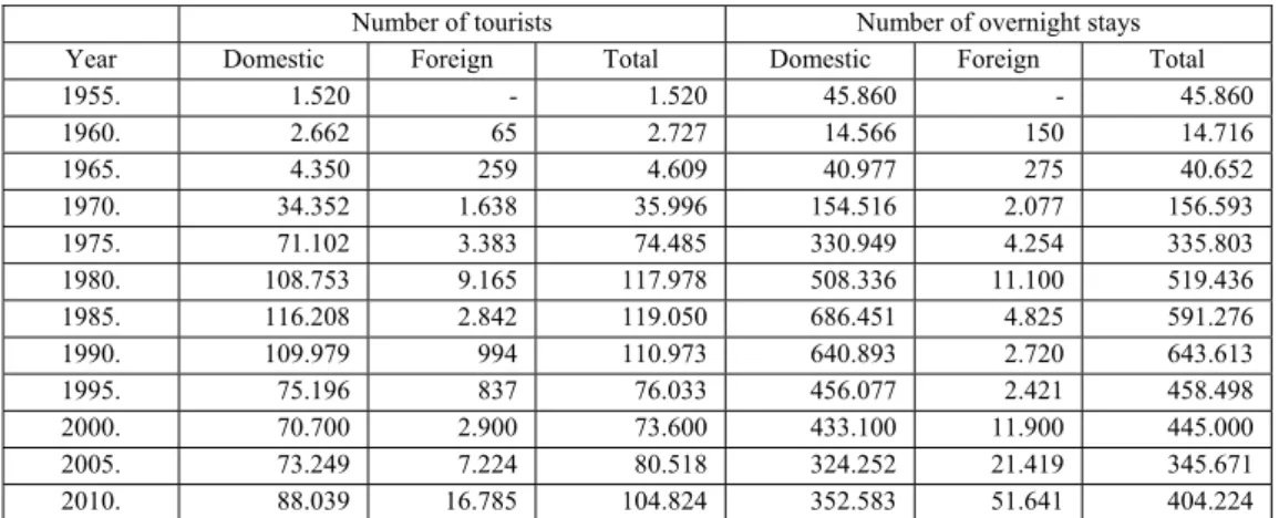
A remarkable touristic and geographic position, as well as numerous natural and anthropogenic values make Zlatibor exceptionally significant for the development of national tourism which can be seen in a yearly tourist turnover (Ivanović M., 2007). Table 1 shows the number of tourists and the number of overnight stayings on Zlatibor from 1995 to 2010 in five-year periods.
Table 1. Tourist Turnover on Zlatibor from 1995 to 2010.
Number of tourists Number of overnight stays
Year Domestic Foreign Total Domestic Foreign Total 1955. 1.520 - 1.520 45.860 - 45.860
1960. 2.662 65 2.727 14.566 150 14.716
1965. 4.350 259 4.609 40.977 275 40.652
1970. 34.352 1.638 35.996 154.516 2.077 156.593
1975. 71.102 3.383 74.485 330.949 4.254 335.803
1980. 108.753 9.165 117.978 508.336 11.100 519.436 1985. 116.208 2.842 119.050 686.451 4.825 591.276 1990. 109.979 994 110.973 640.893 2.720 643.613
1995. 75.196 837 76.033 456.077 2.421 458.498
2000. 70.700 2.900 73.600 433.100 11.900 445.000 2005. 73.249 7.224 80.518 324.252 21.419 345.671 2010. 88.039 16.785 104.824 352.583 51.641 404.224 Source: Stanković S., Ćirković S., 2002 and the Statistic Annual of the Republic of Serbia
According to Stanković and Ćirković (2002), the highest number of tourists registered was in 1981 (122853) and the highest number of overnight stays was in 1990 (643613). The highest tourist traffic is realized in January, August and July, and the number of domestic tourists is much higher than of the foreign ones.
Another characteristic of Zlatibor is that it is possible to develop various types of tourism, such as health and wellness tourism, sport and recreational tourism, rural, ethno tourism and ecotourism, congress and event tourism, hunting tourism, excursion tourism etc.
Spatial planning in tourism
Spatial planning is a conscious and planned activity, which is aimed to choose an optimal structure of facilities and equipment in a given area based on the valorization conducted and in function of previosly established volume of demand, potential supply and socioeconomic goals of the society (Dredge D., 1999; Jovičić D., Ivanović V., 2006; Piha B., 1982).
spatial planning also serves as an instrument of economic activity distribution, politics and social welfare amongst regions, when it is also labeled as national-regional planning. On a regional level, spatial planning is an instrument of the development modeling. In the end, on a local/municipal level, in most countries spatial planning is primarily focused on planning how to use the land, with the aim to regulate the use regime and ownership relationships on lots (Đorđević D., Dabović T., 2004).Spatial planning of tourism is a component of the overall development plans, whose aims and tasks are complementary with the efforts for the country development as a whole. In terms of time period they are related to, 3 types of plan are distinguished: short-term plans (from 1 to 3 years), medium-term plans (from 3 to 10 years) and long-term plans (from 10 to 25 years). In terms of spatial coverage, tourism planning can be local (one or more municipals), regional (one or more regions, counties, provinces in a country), national (on a national level) and intra regional (several countries in a certain regional unity – Alpe-Adria, Podunavlje) (Stanković S., 2003).
Natural factors, on the destination of Zlatibor in this case, are primary in every planning and designing, because they cannot be changed, so large sums must be spent in order to modify them if they are not adequate for a given purpose. The expertise which follows or precedes the planning or programming is usually supposed to be based on quantity evaluation of certain parameters, as the transparency of the method and subsequent corrections are ensured in this way (Lješević M., Milanović M., 2009).
Spatial planning in tourism is a planned and continuous activity of the society, which is aimed to organize, arrange and equip certain spatial entities in the function of their marketing possibilities, available tourist potential and socioeconomic goals, with the effort to maximize the positive and minimize the negative social, economic and spatial effects of tourism (Stanković S., 2003).
Spatial planning in tourism, as an integral type of planning which involves social and economic aspects is increasingly becoming a necessity and a practice, which is also pointed out by the World Tourist Organization research. Due to increasing development of mass tourism and larger number of countries and regions involved in the tourist flows, it is practically impossible to leave spatial development and the development of tourism in general to chance, which is being advertized by some of the negative experiences in certain countries and regions, where there has been an uncontrolled proliferation of tourism and degradation of the environment (ČomićĐ., 1988).
Research methods and research methodology
Research results using a review of the existing planning documents
Administratively and spatially Zlatibor is mostly part of the Municipality of
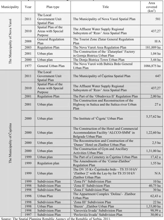
Čajetina, and a smaller part belongs to the Municipality of Nova Varoš. According to the Planning and Construction Act (2011), spatial and urban planning documents are: planning documents, implementation of spatial planning documents and urban-technical documents. Planning documents consist of spatial and urban plans. Spatial plans are: The Republic of Serbia Spatial Plan, Regional Spatial Plan, The Local Government Unit Spatial plan an the Spatial Plan of the Areas with Special Purpose. Urban plans are The General Urban Plan, The General Regulation Plan and The Detailed Regulation Plan. Table 2 shows spatial documents which regulate the territory of the tourist destination of Zlatibor.
Apart from these plans, the Republic of Serbia Spatial plan (2010), the territory of Zlatibor and the Administrative District of Moravica Regional Spatial Plan for (2012) and Business (Master) of the tourist destination of Zlatibor-Zlatar (2007) are especially significant.
The Republic of Serbia Spatial Plan is and ‘umbrella’ planning document which regulates the use, arrangement and the protection of the country’s territory (ĐorđevićĐ., 2010). The basic goal of the Republic of Serbia Spatial Plan is the spatial and the ecological support in accomplishing the sustainable tourism development concept, by compromise in integrating the principles and strategic and planning documents for tourism development, protection and arrangement of the tourist areas, along with the optimal meeting of social, economic, spatial and ecological and cultural needs on the national and local level, the market interest and the terms of transboundary and international cooperation.
In the Plan, Zlatibor is recognized as a tourist center and the area of endangered environment, where it is necessary to prevent further degradation and ensure the improvement of the current state. Zlatibor is also pointed out as an area with good environment where positive influences on human, wildlife and quality of life prevail, so it is necessary to provide with the solutions which eliminate or reduce the existing sources of negative influence and increase the positive affect as a comparative value in development planning.
Based on previous research and valorization, according to this Plan, defining of the status, spatial coverage and protection regimes are being expected for the territory of Zlatibor. The special significance of the cluster protected area Mokra Gora and Zlatibor is being emphasized, in order to strengthen the transboundary construction.
Within protection and sustainable use of the cultural heritage in order to contribute to the maintaining of the regional and local identity in accordance with the European standards of protection and based on the research and valorization which was conducted by the Republic Institute for Protection of Cultural Monuments of Serbia, a list of cultural areas has been proposed, as well as a list of monuments which make the conceivable cultural landscape units along with the immediate environment, including the area of Užice and Zlatibor.
The territory of Zlatibor is among strategic priorities-projects up to 2014, for which a production of special pilot projects of the ‘Landscape characterization’, as a basis for protection, planning and managing its development and the area in which the quality of landscape and physical structure of the town is especially important and is an important tourist destination.
most significant positive effects are being expected precisely here on the territory of Zlatibor.
Table 2. Spatial documents which regulate the territory of the tourist destination of Zlatibor
Municipality Year Plan type Title
Area covered
(km2)
2011
The Local Government Unit Spatial Plan
The Municipality of Nova Varoš Spatial Plan 581
2010
Spatial Plan of the Areas with Special Purpose
The Affluent Water Supply Regional
Subsystem of ‘Rzav’ Area Spatial Plan 437,27
2008 General Regulation Plan The Tourist Zone Zlatar General Regulation Plan /
2003 Regulation Plan The Nova Varoš Area Regulation Plan 181,889 ha
2001 Urban plan The Construction of the ‘Zlatarplast’ Factory
in Gornja Bistrica Urban Plan 1,04 ha 2000 Urban plan The Donja Bistrica Town Urban Plan 3,44 ha
The Municipality
of Nova Varoš
1977 General Urban Plan The Nova Varoš with Babića Brdo General
Urban Plan 1086,875 ha
2011
The Local Government Unit Spatial Plan
The Municipality of Čajetina Spatial Plan 647
2010
Spatial Plan of the Areas with Special Purpose
The Affluent Water Supply Regional
Subsystem of ‘Rzav’ Area Spatial Plan 437,27
2001 Regulation Plan The Part of the ‘Obudovica II’ Regulation Plan 2,00 ha
2001 Urban plan
The Construction and Reconstruction of the Highway in Sušica and the Sušica river Urban Plan
27 a
2000 Urban plan The Institute of ‘Čigota’ Urban Plan 5,37,62 ha
2000 Urban plan
The Construction of the Hotel and Commercial Accommodation Facility ‘ALCCO-SMM’ in Belgrade Urban Plan
1,22,60 ha
2000 Urban plan The Reconstruction and Construction of the
‘Dunav’ Hotel on Zlatibor Urban Plan 2,5 ha
2000 Urban plan The Construction of Gym and Ancillary
Activities Urban Plan 1,31,00 ha 1999 Urban plan The Part of a Cemetery in Čajetina Urban Plan 17,42 a
1999 Regulation plan The Amendments of the ‘Centar-Zlatibor’
Regulation Plan 1,55 ha
1999 Urban plan
The DV 35 Kv Čajetinsko brdo – TS 35/10 kV ‘Zlatibor 2’ with the Lay-by for TS 35/10 kV Zlatibor Urban Plan
N/A
1999 Subdivision Plan ‘Zona IV’ Subdivision Plan 10 ha 1998 Subdivision Plan ‘Zona II’ Subdivision Plan 40,75 ha 1998 Subdivision Plan ‘Zona I’ Subdivision Plan 30 ha
1998 Urban Plan The Appartment Complex ‘Dolina’- Zlatibor
Urban Plan 62,43 a
1998 Subdivision Plan ‘Zona III’ Subdivision Plan 22 ha 1998 Urban Plan ‘Bazen’ _Zlatibor Urban Plan 1,33,00 ha 1998 Subdivision Plan ‘Gavovića livada’ Subdivision Plan 98,99 a
The Municipality
of
Č
ajetina
1997 Subdivision Plan ‘Pavlovića livada’ Subdivision Plan 30,00 a Source: The Spatial Planning Republic Agency of the Republic of Serbia, 2011.
national, regional and local development interests. The basic task of this document is to offer development strategies and spatial plans which will enable the protection of the values and valorization of this area’s benefits for the long-term and balanced economic growth, which will ensure the plan basis for: rational organization, construction, arrangement and utilization of the area; environmental protection; improving life quality of the locals by improving the infrastructure and utilities and by economic growth and guidelines for the institutional, organizational, administrative control and the IT application support. This plan was passed for the period until 2025, with the elements for the first, priority implementation phase for the period until 2016.
According to this plan, the territory of Zlatibor is part of the tourist cluster of the Central and West Serbia, where the mountain center of Zlatibor stands out with the highest number of overnight stayings within the Administrative District of Zlatibor and Moravica in 2009.
According to this Plan, the tourism promotion, supply and demand coordination and cultural and educational activity carriers in tourism are the tourist organization of the West Serbia region, the tourist organization of Zlatibor and other minicipality centers.
The territory of Zlatibor stands out as an area of exceptional diversity, attractivness and beauty of landscape, and St. Peter and Paul Church and the Staro selo complex in Sirogojno are especially emphasized in terms of immovable cultural property.
Health, recreational and wellness centers are especially emphasized for the tourism development on Zlatibor. Other potential tourist and recreational offers are: the development of other types of tourism, especially excursion, sports and recreational, rural, ecotourism, special interest tourism, transit tourism and ski tourism.
One of the Plan’s goals is also the development of processing and placement of the traditional local products of a well-known brand, origin and quality (the protection of geographic origin and regional branding) in interplay with the development of rural, recreational, cultural and ecotourism, the renovation of the rural architecture and infrastructure and the fostering of the cultural and historical heritage.
In terms of organization and arrangement of the tourist area as a Plan, it is determined for the parts of the tourist destinations, as well as other tourist areas to be organized according to plan through tourist areas where forming of the integral tourist offer is possible. The global zoning of the relevant part of the Zlatibor and the Moravica District is differentiated according to plan to four tourist areas, and one of the areas is Zlatibor with the area of Zlatar and Pešter (Sjenica). The main tourist offer of the areas will be organized in the following tourist complexes: Zlatiborsko-Užički, Ariljsko-Rzavski, Zlatarsko-Novo Varoški and Peštersko-Uvački. The condition for the development of the tourist complexes is the completion of better protection, presentation and tourist interpretation of natural and cultural values, better traffic accessibility along with better integration with the cities and community centers as the organizational cores of the offer.
Sušičko vrelo stands out as one of the protected areas on Zlatibor. In terms of guidelines for the creation of other planned documents, based on the Plan, the Government of the Republic of Serbia is supposed to pass the tourist destination of Zlatibor-Zlatar Spatial Plan of the Area With Special Purpose until the end of 2016.
Business (master) plan of the tourist destination of Zlatibor-Zlatar provides with the development of this destination until 2015 and emphasizes the complementarity of the resources for tourism development. The basic task of this project is to analyse the state of tourism development of the destinations and point out to the future course for further development of the destination and give suggestions for the strategic and operational measures.
speleological facilities such as the Stopić and Rakovička caves. Furthermore, the Plan gives suggestions for the protection of Zlatibor as a Nature park on a three-level protection regime. The protected natural properties are: the Park šuma reservation, the three pine trees, the natural monument Stopića cave, the monument Staro selo complex in Sirogojno.
Within the Master plan the problem of a large number of uncategorized accommodation facilities is being pointed out, as well as the problem of sport and recreational infrastructure.
Mountains and lakes in winter and summer offers are emphasized as key tourist products, as well as the special interests tourism through various recreational activities, rural tourism, cruise excursions and health tourism, with a special emphasis on the development of wellness tourism and the construction of adequate facilities for the development of this type of tourism, business tourism and events and nautical tourism (refers to the territory of Zlatar).
Through the Master Plan the most significant projects which could affect the tourism development on Zlatibor are being pointed out: rehabilitation and the expansion of the Zlatibor center-Tornik ski center, the protection, arrangement and use of the Zlatibor lakes, the expansion of the Tornik ski center facilities, the construction of the Obudojevica-Tornik gondola lift and the construction of the new bus station at the Zlatibor outskirts, the construction of public parking lots, the investment into local highways, the construction of the Zlatibor bypass as well as other investments which would contribute to the improvement of the quality of the tourist product.
Discussion
Original territory may become coherent and more attractive for the retention and employment of the locals under the influence of tourism. On the other hand, under its influence the original territory may become overloaded with facilities and people, degraded and changed so it no longer possesses the rareness and autochthonous qualities. During the transformation process, the original territory of Zlatibor has undergone some positive but also negative consequences.
In the last decade of the 20th century as well as in the beginning of the 21st century the development of tourism on Zlatibor has taken the wrong course. Instead of a tourist destination Zlatibor has become a type of settlement whose main function is tourism, with no adequate planned development and control and which deviates from the natural environment. Illegal construction and urban chaos have reduced the tourist attractiveness of Zlatibor. During the last decade of the 20th century there have sprouted fast food facilities, restaurants and bars with no adequate hygienic and technical and sanitary conditions, spatial and physiognomic regulation and Zlatibor is increasingly being mentioned as a destination with great night life. There are green market and flee market located at the centre, a big parking lot and sport facilities (Dragović et al, 2009).
With such irresponsible behaviour the development of tourism on Zlatibor has been significantly jeopardized and it is necessary to make sure that the current state is changed and adjusted to the real needs of the mountain tourist destination. Aesthetic degradation is being pointed out as an especially significant problem, where the principles of preserving the autochthony of the landscape and architectural style are not being applied.
Besides numerous territory planning documents, such intensive development of tourism on Zlatibor would lead to total degradation of the nature, the extinction of plant and animal species, devastation of the forests and this will subsequently contribute for the tourism to be impossible to develop further, which will consequently adversely affect the local community.
The environmental protection is a necessary segment in territorial planning, however the disadvantage of a large number of planning documents is the incompatibility of the segments of the environmental protection with the other segments of the plan, i.e. the collision between the environmental protection and planned activities which can significantly endanger its quality. Spatial plans often look like a group of several independent analytical studies with no necessary synthetic component (Filipović D., Obradović D., 2005). The Master plan of the tourist destination of Zlatibor-Zlatar provides with the adoption of the act on Zlatibor protection as a Nature park. With this act the activities of spatial planning may become the key activities of ensuring the sustainable development (Hełdakl ., Raszka ., 2011).
The positive effects of tourism on Zlatibor are fewer than the negative ones. Tourism on Zlatibor has affected the economy of this region, revitalization and construction of certain facilities and superstructure. In terms of construction of the accommodation facilities, the apartment complex Kraljevi konaci stands out, which was built with respect to aesthetic and environmental requirements and as such it can serve as the basis for starting the positive urban and architectural processes in tourism on this territory.
In order for the spatial planning to ensure the development of tourism which will benefit in the long term for all stakeholders and the environmental protection, it is necessary to:
‐ affect the awareness of both local community and the tourists not to view the territory of Zlatibor as an area which brings a short-term benefit. It is necessary to raise the awareness on the significance of the sustainable development and viewing this area as a strategically significant for the development on all levels;
‐ ensure the tourist products which do not require further construction of facilities, which would reduce the negative aspect of the already disturbed and degraded environment of this area;
‐ better accordance among the territorial plans on all levels;
‐ stopping illegal construction as one of the biggest problems in this area; ‐ ensure compliance with the Spatial Planning Act and spatial plans on all levels; ‐ ensure the demolition of the illegally constructed facilities or their rearrangement
into facilities which would contribute to further sustainable development of the destination;
‐ encourage partnerships of the private and the public sector and aid in terms of developing entrepreneurial ideas, with the emphasis on projects which will bring benefit not only to entrepreneurs but the destination in general ;
‐ ensure the compliance with carrying capacity of Zlatibor, i.e. ensure the traffic which would contribute to the positive affect of tourism on the local residents, the environment and the tourists (Magaš D., 2003);
In case the above guidelines are not respected, Zlatibor will lose its air spa purpose, which it gained in the beginning of the 20th century, but also the tourist value which it gained as an area of exquisite beauty. Environmental protection and tourism development are not a matter of one person and specialized social and professional organizations. It is about the need to engage the whole social community, as environmental protection is for the needs of tourists and at the same time the environmental protection it is from the tourists for the domicile residents and their numerous needs. Environmental protection, its improvement and valorization are the basis for the improvement of people’s quality of life. This is why we potentiate the justification of the opinion that the modern protection must rest on the conception of active protection. Its supporters are in increase. It arises as correct and it can be applied in a complex way and without compromise, everywhere and always, in order to achieve the desired results (Stankovic S., Pavlovic S., 2006).
Environmental protection for tourism cannot be reduced to conservation of the natural complexes for the nature. Environmental protection actions must be arranged in such way that the area protected serves in a most possible way the vital needs of people, not only the current generation but also the ones to come, not only from the aspect of current, but long-term effects. Arrangement of the environment is part of the effort to manage natural sources and use the appropriate purposeful area. Environmental protection must be a special type of planning, which precedes the economy and social growth. A versatile cooperation of scientists and practitioners, social and political organizations and productive work are needed for the realization of such setting. Only in this way can and must favorable conditions for the initiative and receptive tourism be created and understood in the large number of economic and uneconomic functions (Stankovic S., 2003).
A large number of authors, researchers and those who are engaged in tourism planning suggest that the local community should be involved in the tourism development, in order to reduce the negative effects of tourism and maximize the benefit from tourism (Chambers R.,2002; Sewell D., Coppock J. 1977; Rohe W.M., Wates N. 2000; Wang A., Pfister R.E., 2008).
Zlatibor should be designed and put on the market as the center of mountain tourism accessible to tourists during the winter and the summer, along with the development of tourist products which would stop or prevent further degradation of the environment.
Presently, domestic tourists are mainly the visitors on Zlatibor and in perspective they could be target groups of foreign tourists who are the participants in a congress or symposium who could enjoy the healthy climate, intact nature, the richness of flora and fauna between two lectures. Organizing manifestations, film festivals, conferences, sport manifestations and other forms of socializing could bring full capacity and the prolonging of the tourist season on Zlatibor.
Special emphasis should be put on the trainings of sports teams who would be provided with excellent conditions. A large number of sports teams would use the conveniences that Zlatibor has to offer during their training period.
Zlatibor has all the requirements to become the center of health tourism in Serbia. Staying on Zlatibor helps for the treatment of certain illnesses as well as rehabilitation, whether it is preventive or a treatment.
Zlatibor is supposed to be the central destination for the staying of transit tourists which transit in the summer, as well as those who are moving throughout the year in this area.
Conclusion
The increasing pollution of the urban areas is creating an increasing need for the intact nature and its recreational features. Due to its great and diverse recreational and therapeutic characteristics and the increasing pollution of the environment, Zlatibor receives an increasing national and regional significance. With the improvement of the modern civilization, Zlatibor’s values increase and for that reason it should be revitalized with planned measures and protected from any type of pollution in order to use its natural beauty in the best way.
Only managing the territory of Zlatibor properly, as a resource for the needs of tourism will contribute to the increase of its economic, ecologic and aesthetic value which will ensure a long term benefit on a local, regional and national level.
Tourism encourages urban traffic and the migration of the residents, and the tourist development accelerates the urbanization. Tourist development unavodably accelerates the transformation of former rural and urban areas. Along with the tourist development and the urbanization the quality and the diversity of the urban infrastructure also gains significance which is a long term planning which will meet the expectations of the local community as well as the guests (Manyara G., Kesgin M., 2007). The condition for this is professional management of the tourist destination of Zlatibor which must establish a clear vision for the future development of this territory in the following period, primarily through the development of rural, ecotourism, ethno tourism and gastronomic tourism, with the cooperation and listening to the needs of the locals, in order to revitalize, improve and above all protect this area of exquisite beauty and value.
References
Vučetić, Š., Bunja, Đ. (2008): Osposobljavanje lokalne zajednice za turistički razvoj, U Zbornik radova znanstveno-stručnog skupa ,,Ekonomika i menadžment u javnom sektoru”, Rijeka: Ekonomski fakultet Sveučilišta u Rijeci.
, . , . , . (2009). -
, , 89
(1),15-128.
Dredge, D. (1999): Destination Place Planning and Design, Annals of Tourism Research, 26 (4), 772-791.
Ђ ђ , . (2010): , , 42 (1-3), 3-6.
Ђ ђ , ., , ., (2004). ,
, 84 (2), 83-98.
Ђ , ., , . (2005). З , : .
, (2007). , ,
, , 11. 167-170.
, . , . (2006). , : .
, ., , . (2009).
, , 89 (3), 51-58
Magaš, D. (2003). Management turističke organizacije i destinacije, Opatija: Sveučilište u Rijeci, Fakultet za turistički i hotelski menadžment.
ČomićĐ., (1988). Prostorno planiranje u turizmu, urizam, br. 3, Zagreb: Turistički savez Hrvatske. Piha, B. (1982). Planiranje turizma i svakodnevne rekreacije u samoupravnom društvu, Beograd: PFV. Rohe, W. M., Gates, L.(1985). Planning with Neighborhoods. Chapel Hill: University of North Carolina Press.
, , . (1991). З , . :
, , . DCVII, , . 100.
, 2011, :
http://www.rapp.gov.rs/index.php?jezik=s
., . (2006). , З , . 54, 143-162.
, . , . (2002): ,
, 82 (1), 31-44.
, ., (2003). , , ,
, . (2006): , : ,
- , , .
Sewell, D. Coppock, J. (1977). Public Participation in Planning. Chichester, UK: Wiley.
, . , . (2005). –
ђ ,
, 85 (2), 119-126. , .(1987). З
, : , 88-92.
Harris, M J. (2000). Basic Principles of Sustainable Development, Medford, USA: Global Development and Environment Institute, Tufts University, Working Paper 00-04.
Hełdakl, M. Raszka, B. (2011). Prognosis of the Natural Environment Transformations Resulting from Spatial Planning Solutions, Polish Journal of Environmental Studies,. 20 (6), 1513-1518.
Manyara, G. Kesgin M. (2007). Percepcije lokalnih vlasti i nevladinih organizacija o turističkom razvoju i urbanizaciji Alanyje, Turizam, 55 (3), 309-322.
Chambers, R. (2002). Participatory Workshops. London: Earthscan.
Wang, A. Pfister, R.E. (2008).Residents’ attitudes toward tourism and perceived personal benefits in a rural community. Journal of Travel Research, 47 (1), 84-93.
Wates, N. (2000). The Community Planning Handbook. London: Earthscan.
*** (2009). З , . a , . 72/2009, 81/2009 - a a, 64/2010 - o a
24/2011), : ,
.
*** (2007). ( ) З – З , :
, џ .
*** (2010). 2010 -2014 -2021 ( ). : .
*** (2012). З –
, : ,
.
*** (2011). . : .
Ј Њ
Ј
∗1
, 2, . 1
, 3
11
, Ђ 9,
2 , - ,
, 3,
3 џ ,
110,
: ,
.
, ђ
, ,
,
.
.
, .
, ,
, ,
.
: , , , .
,
, . ,
ђ , ,
.
, a , a 30 km, a
12 km, a , , , , ,
, (Ђ ., ., 2005).
, ђ
. 19. 20.
. ђ ,
20
, .
( ., 2009).
,
, ,
( B., 2006), ,
(Harris M. J., 2000).
,
.
∗ E−mail: [email protected]
-
1.015
km2 11% .
ђ 17° 14′ 17° 28′ ђ 43° 36′ 43° 48′
. .
,
55 km. - 25
km . ( )
Ђ , , (
., 2009). 1000 m.
, , , , , , ,
.
.
.
, (2009)
,
.
.
,
,
, .
1.500 m ( 1.496 m, 1.462 m, 1.438 m, 1.422 m),
(1.600 m) ( C.,
., 2002).
. ,
. .
, 2.000
.
. 80 ,
.
,, “ – ( ., 1991).
,
, , ,
.
( , , , , ),
.
( , , , ),
( , , , ),
. , ,
, ,
. ,
, ,
, 1992.
( ., 1987).
- ,
( ., 2007).
1. 1955. 2010.
1. 1955. 2010.
: ., ., 2002 ,
2011.
(2002)
(122.853) 1981. , (643.613) 1990. .
, , a
.
wellness ,
- , , ,
, , .
,
, ђ ,
- (Dredge D., 1999; ,, ., 2006; Piha
., 1982).
–
, .
,
.
( , , , ), ( ),
( ),
( , ) ( ).
ђ ,
- . ,
. , / ,
,
(Ђ ђ ., ., 2004).
.
, : ( 1 3
), ( 3 10 ) ( 10 25
). (
), ( , , ),
( ) ( ђ
– - , ) ( ., 2003).
, ,
, , ђ
.
, ђ
( ., ., 2009).
,
, ђ ђ
,
- ,
,
, ,
.
,
, , ,
,
( Ђ.,
1988).
,
(2010),
(2012) ( )
-(2007),
.
,
.
, ,
- , ,
,
.
, .
(2011), :
, ђ
-. .
: , ,
.
,
. 2.
.
(2010),
(2012) ( )
- (2007).
,, ”
, ђ (Ђ ђ ., 2010).
-,
, , ђ
, , ,
,
ђ .
,
. ђ
, .
,
, .
, .
ђ
,
-, ђ - .
ђ
-2014. , „
”, ,
.
ђ ,
. ђ ,
, ,
.
,
.
-
,
: , , ђ
; ;
ђ
- ,
-. 2025. ,
, 2016. .
,
- 2009. .
,
,
, .
,
,
. .
, wellness
. :
, , - , ,
, ,
.
, , (
), , ,
,
2.
(km2)
2011 581
2010
" "
437,27
2008 /
2003 ђ. . 181,889 ha
2001 . " " 1,04 ha
2000 3,44 ha
1977 .
1086,875 ha
2011 647
2010
" "
437,27
2001 " II" 2,00 ha
2001
27 a
2000 " "- 5,37,62 ha
2000 . . - .
.-" ALCCO-SMM.-"- 1,22,60 ha
2000
" "- 2,5 ha
2000 1,31,00 ha
1999 17,42 a
1999 " - " 1,55 ha
1999
DV 35 kV - TS 35/10
kV " 2" TS 35/10 kV N/A
1999 . " IV" 10 ha
1998 . " II" 40,75 ha
1998 . " I" 30 ha
1998 " "- 62,43 a
1998 . " III" 22 ha
1998 " "_ 1,33,00 ha
1998 . " " 98,99 a
1997 . " " 30,00 a
: , 2011.
ђ
, ,
.
, ,
:
-, - , - - .
, ,
,
.
. ,
2016.
- .
( ) - ђ
2015. .
,
, .
:
. ђ ,
. :
, , ,
.
, - .
, ,
, ,
wellness ,
ђ ( ).
: –
, , ђ ,
, –
, ,
, ,
ђ .
, ђ
.
,
.
,
.
20. 21.
.
,
.
. 20.
,
, ,
. ,
ђ
, ђ ђ , , ,
.
ђ , ,
.
,
.
,
ђ , .
.
,
.
- ,
,
, ,
, .
, ђ
ђ
, ђ
.
( ., ., 2005).
- ђ
.
ђ (Hełdakl ., Raszka ., 2011).
. ,
.
ђ
.
:
‐ , ,
.
;
‐ ,
;
‐ ђ ;
‐ ;
‐
;
‐ ђ ђ
;
‐
,
‐ ,
,
(Magaš D., 2003);
‐ џ
(Vučetić Š., Bunja Đ., 2008).
,
, 20. ,
.
. ,
, ,
. , ђ
, .
. .
, ,
( ., ., 2006).
.
ђ
, ,
, . ђ
. ,
.
, - .
(
., 2003).
, ,
,
(Chambers R.,2002; Sewell
D., Coppock J. 1977; Rohe W.M., Wates N. 2000; Wang A., Pfister R.E., 2008)
,
.
ђ , ђ
, . , ,
, ,
.
.
ђ .
.
ђ ђ
.
, .
, .
ђ ,
.
ђ ,
. ђ
, ,
ђ
.
,
, ,
, .
,
.
.
.
,
(Manyara G. , Kesgin M., 2007). џ
, , ,
, ,
, ,
.