ISSN 1549-3644
© 2009 Science Publications
Corresponding Author: Diallo Yacouba, Faculty of Earth Resources, China University of Geosciences, 430074-Wuhan, Hubei, Republic of China
Simulation Planning for Sustainable Use of Land Resources:
Case study in Diamou
1
Diallo Yacouba,
1Hu Guangdao and
2Abdurazak Hussien Abdulahi
1
Faculty of Earth Resources, China University of Geosciences,
430074-Wuhan, Hubei, Republic of China
2
Faculty of Environment, China University of Geosciences
430074-Wuhan, Hubei, Republic of China
Abstract: In this study, we presented the simulation planning scheme to project land and land resources use changes at a local scale for Diamou (MALI). Problem statement: All the land cover types were under the influence of human and livestock population. Diamou has undergone changes in land-cover over the last decades. The shifting cultivation system practiced was probably the main reason for this state of affairs. Moreover, the dryness and extensive character of pastoral activities had contributed to the general degradation of natural resources. The principal objective of our study was to contribute to the sustainable use of land resources from 1999-2010. Approach: Using formula the resources supply and demand had been estimated based on statistics data, derived from a comprehensive review of the literature. The resources balance (difference between supply and demand) had been estimated for two years 1999 and 2010.The resources demand were measured by an average consumption needs person−1 day−1 multiplied by the population. For the livestock population the biomass demand and supply had been measured based on TLU dietary requirements and the pastureland carrying capacity. The diagram of resources balances were drawn using word Microsoft word command and the simulation land use areas schema using ArcGIS. Results: From present approach, it was found, that, in year 1999 the fuel wood and cereal balances were negative. The drink water and biomass balances were positive. The dominant land use categories were the pastureland and the cropland, occupying about 52 and 45% of total area respectively of the total area 8876 ha. Except the biomass balance in year 2010, all the resources balance were negative. The drink water and fuel wood deficits were equal to 439 and 2801 m³ respectively. The dominant land use class, a cropland covered approximately 45% of total area. Conclusion: Studies had indicated the cereal, fuel wood and drink water resources deficit in years 1999 and 2010.
Key words: Diamou, Planning, sustainable use, land resources, pressure
INTRODUCTION
Most land cover modification and conversion is nowadays driven by human use rather than natural change. Some locale studies have shown, that since the early 1970s, the Sahel countries have been suffering from chronic food shortages caused by economic crisis, poverty, desertification and climate changes. After Stephenne and Lambin[28,29], the Sudano-sahelian region has undergone changes in land-cover over the last decades[3]. However, it is still debated to know whether these changes are related to short-term climate fluctuations or longer-term anthropogenic impacts[15,17]. The shifting cultivation system practiced in Diamou was probably the main reason for this state of affairs.
Moreover, the dryness and extensive character of pastoral activities, have contributed to the general degradation of natural resources. As a result, the land/man and arable land/ man ratio in Diamou decreased to 3 and 1.4 ha; respectively. Many important plant species of which Vitellaria paradoxa (Si), Prosopis africana (Guélé), Elaeis Guineensis (N’té) Oxytenanthera abyssinca (Bonego), Borarsus aethiopum (Sibo), Cordyla pinnata (Dougouto) are extremely rare and considered threatened. According to to the climate type[14,17]most of inventoried soils units are poorly drained, shallow with high gravel content or Massive structure, low fertility.
16 rapidly dry and children and women had to walk far away to fetch water.
The stock of its natural resources includes land, minerals, water, flora and fauna and is the backbone of the economy and the livelihoods of its inhabitants. Negative land use-cover change processes, understood as the change from any primary dominated land cover into any man-made dominated one, have largely resulted as desertification, deforestation, habitat fragmentation, biodiversity loss and eventually into global warming[10] and reduction of environmental services[21]. In Diamou the diet is composed by cereals for up to 83[19] of the total consumption. Local-scale studies and regional surveys estimated that 90% of the energy needs of households are covered by wood. The pastoralism is extensive, the biomass output for the livestock feeding depends on the rainfall and need to be evaluate as many others resources. Diamou remains an important economic and pastoralism center. Most studies have been focused on the land planning and land degradation, without resources estimation. The principal objective of our study was to contribute to reach the sustainable use of land resources from 1999-2010. The rest of the study is organized as follow: section two, presents the material and methods. Section three presents our simulation results. Section four presents our discussions and finally Section five, conclusion.
MATERIALS AND METHODS
The equipment needed to carry out the study is composed:
Computer and ArcGIS software: Topographic map (West Africa) at a scale 1/200000, Kayes ND-29-XIII.
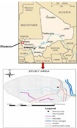
The study area Diamou located in the south western part of Mali covers approximately 8876 hectares in the Kayes Region and lies between latitudes north 14°0’-14°10’and longitudes west 11°10’-11°30’. Its boundaries are Balandougou in the north, Hameya in the south, Hamanda in the west and the river Senegal in the east. The climate is characterized by its sudano-sahelian type with a long dry season (September-may), divided in cool period from November to February and warm period from March to June. The main rainy season extends from June to September or mid October. As a tropical climate
,
it is characterized by a dry season controlled by warm and tropical air masses (Harmattan) at times of high sun and by a rainy season controlled by the continental tropical air masses (Mouson) at times of low sun. The climate data are obtained from country Meteorolocal Service.Fig. 1: Diamou location, indicated by red box is extended as a study area
The yearly average mean rainfall is about 650 mm and an annual average temperature is about 27°C with a maximum of 45 degrees Celsius. The maximum of rainfall obtained is 750mm and the minimum is 550mm (Fig. 1). The relief of Diamou is mostly flat with some hill slopes in its South and South-west parts. There are four land cover units/land cover types: the hill slope, The table land, the plain and the terrace land[21,29]. The Hydrology is represented by the Senegal River to the East.
The practical approach was composed by Bibliographic research or literature review and Balance estimation of water and land resources, resources chart design and developing a land-use plan.
changes in Sudano-sahelian countries and general international literature.
The balance (difference between supply and demand) for land and water resources was estimated based on statistics data, using some equations described:
Local-scale studies in the Sudano-sahelian countries estimate an average of 250-375 kg of millet and sorghum production to feed an average person during 1 year[2,3,25], In these countries, the diet is composed by cereals for up to 83-90%[19,26] of the total consumption. In Mali the basic consumption requirements varies from one region to another. In Koulikoro Region it is 233 kg of grains inhabitant−1 year−1, 221 kg in Sikasso, 226 kg in Mopti[19]. The basic consumption of the Diamou population is estimated at an average value of 226 kg of grains per inhabitant[16]. The food consumption needs is measured by the population multiplied by the average consumption requirements of a person during one year. Thus, in year 1999, it was 2849 * 226 = 643.874 tonnes and in year 2010 it will be 3789 * 226 = 856.314 tonnes. The projected population is estimated according to the general growth rate equation from the work of[8] as:
Pn = Po * (1+r)n (1)
Where:
Pn = The population in year n
Po = The initial population R = The birth rate N = The number of years
Table 1: Crop yield (kg−1 ha−1)
Crop Yield kg−1 ha−1 Agricultural
area, --- output Cultivation in ha Min Average Max (In tonne) Sorghum 427 367 571 775 244
Maize 383 244 452 660 173
Millet 301 248 399 550 120
Rice 79 570 835 1100 66
Groundnut 55 350 825 1300 45
Total 1190 603
Note: Table data were used to estimate the cereal balance[3,26]
Table 2: projected crop yield ( kg−1 ha−1)
Crop Yield kg−1 ha−1 Production or
area, --- agricultural Cultivation in ha Min. Aver. Max. output(In tonne) Sorghum 648 330 571 850 370
Maize 383 244 452 660 173 Millet 594 270 399 590 237 Rice 79 570 835 1100 66 Groundnut 65 350 850 1350 55
Total 1640 846
Note: Table data were used to estimate the cereal balance
The population growth rate various from 2.8- 3%[30]. For our case r is equal to 3, Po equal to 2849 by substitution the formula (1) becomes simple, Pn = 2849*(1+3%)n Thus the population in year 2010 is approximately equal to 3789 inhabitants.
Agricultural output is measured by the cultivated area multiplied by the average crop yield (Table 1 and 2). The drink water resources balance was calculate as follow: The domestic consumption per year by person is of 4 m³ in Mali, 106 m³ in France and 215 m3 in USA (source: “Water for people, water for life”[13] 4 m³ person−1 year−1 is our calculation basis. In Diamou in 1999th, there were 4 drillings or hand pump of which only1 was functional, 48 traditional wells dug. As we knew the total available water depended on outgoing water per hour and water collection time in hour, it is estimated as:
Wat = (Dh*Wh*Tu) + (Dwel.*Wwel.*Tu) (2)
Where:
Wat = An available drink water
Dh/Dwel = The number of hand pump or traditional wells
Wh = A hand pump outgoing water or flow rate h−1
In Africa Hand pumps are the most common and, in most cases, the only economically feasible water lifting device for community needs. Yield depends on the depth and design, normally in the range of 600-1,500 L h−1 during constant use. Thus, the maximum number of users for any one pump should, ideally, be not more than 150 persons. However in many countries and especially in Africa, the actual number of users per handpump is 500[13]. In our case Dh = 1, Wh = 800l h−1, Dwel. = Wwel. = 70 L h−1 data from by substitution the formula (2) will be as:
Wat = (1*800*12*365)+(48*70*12*365) = 3504000+14716800 = 18220800 L Wat = 18220800 L or 18220.8 m³
18
Qj = q (l/j)* No /1000 (3)
Where:
q (l/j) = The water consumption person−1 year−1 No = An initial population of Diamou in 1999 year
In our case q (l/j) = 4000 or 4 m³[13] No = 2849, by substitution Qj can be expressed as Qj = 4*2849/ 1000 = 11396 m³ or 11396000 L. Eleven years after in 2010 the total water consumption needs: Qj in Diamou will be Qj = 4 m³ *3789 =15156 m³ or 15156000 L.
One of the main characteristics of the pastoral land is its carrying capacity, defined as “the stocking number supported without range degradation, with livestock being well and taking weight”[4]. Depending on ecoclimatic zones, pastoral exploitation systems, estimates of average carrying capacity vary from 10 ha TLU−1 in drier years to 3.5 ha TLU−1 in normal years[4,23]. Actual measurements of carrying capacities are 2 ha TLU−1[16] and 1.25 ha TLU−1[4,6]:
CC = [Sp.Bb.K]/Biomc (4)
Where:
Sp = The pasture land area Bp = The biomass production
K = The rate of this production it is possible to use without "any damage" to the pasture land or coefficient
K, Biomc = TLU biomass consumption needs year−1
The average dietary requirements of a TLU are 6.25 kg of DM day−1[4,6]. The international standard needs of one TLU is 2.5% of its weight, thus TLU biomass consumption needs = 250 kg*2.5/100 = 6.25 kg day−1.
The production from shrubs and trees and crops residues also take part in the biomass consumption of the livestock[7,28]. According to the elaborated schema, the livestock can consume crops residues after harvesting. As saying up the pastoralism is extensive in Diamou. The total DM biomass required to satisfy the average biomass consumption of livestock is estimated as given by[28]:
6.25 kg∗365∗3∗2/3 = 4.6 tonnes year−1 TLU−1
The factor 3 accounts for the consumable fraction of above-ground biomass and the factor 2/3 for the contribution of grasses to the consumption. In the intensification phase the later factor becomes 1/3 (i.e., 2/3 of the consumption is based on crop residues). In year 1999 the total biomass consumption is estimated as follow:
Biomc = TLUn*biomc (5)
where, Tlun is the livestock number, biomc is a biomass consumption need TLU−1 (in ton), in our case the TLUn is equal to 553 and biomc is equal to 4.6 tonnes; thus Biomc = 2543.8 tonnes, what can be arounded to 2544 tonnes.
Eleven years after (in 2010 year) the formula (5) will be as follow as in 1999 year Biomc = TLUn* biomc, TLUn will be equal to 233(transhumants will not be accepted in year 2010), 233 is the resident livestock population, biomc is equal to 4.6 tonnes, thus by substitution:
Biomc = 233*4.6 = 1071.8 tonnes or 1072 tonnes
For many countries for example, the available data are statistically furnished by the great International Institutions. General opinion, these statistics are not very precious, as the reminder. The better methods to evaluate the pasture surface are the use of satellites images high resolution. In arid and semi arid zones the estimation of the surfaces of pasture land is liable of a relative imprecision of about 20%[4,29]. The corrected pasture land area (Spc) is estimated as follow:
Spc = sp-(20%*sp) (6)
sp was an existing pasture land. In our case sp is equal to 4590 ha, the formula 6 gave 3672 ha in year 1999 and 3060 ha in year 2010.
Many authors think that biomass productivity in Sudano-sahelian grasslands only depends on rainfall[20],this is described by the following statistical relationship between dry matter biomass and rainfall:
Bp = 0.15 + 0.00375Ra (7)
Where:
Bp = The biomass productivity in tones ha−1 Ra = The annual average of rainfall in mm
The coefficient (K) corresponds to a rate of maximum exploitation of the aerial biomass, rate beyond of which the pastureland degradation becomes visible[4,7]. The estimations relating to this coefficient are variable according to the types of pastureland and the livestock. In Sahelian region for example we use generally the standard of 33%, but it can oscillate between 25 and 40%. The value of 33% used in our case. Thus, the formula (4) is calculated as follow:
CC = [Sp.Bp.K]/Biomc
In 1999 year, the pasture land area (Sp) was equal to 3672 ha, Bp was equal to 2.6 tones, K was equal to 0.33, Biomc = 2543.8 tones by substitution CC = (3672*2.6* 0.33)/2544 = 1.238 ha TLU−1. In 2010 year, Sp will be equal to 3825 ha, Bp will be equal to 2.6 tones, K will be equal to 0.33, Biomc = 1072 tones, by substitution CC = (3060*2.6*0.33)/1072 = 2.449 ha TLU−1.
The population of Diamou use fuel wood harvested from natural vegetation areas as its main energy source wood consumption and productivity in fuel wood are estimated by forest Inventor. Local-scale studies and regional surveys in the Sudano-sahelian region and in Diamou (MALI) estimate that 90% of the energy needs of households are covered by wood. An average one person uses a minimum of 1 kg of fuel wood day−1[5]. Some studies establish that the consumption needs vary from 0.5-1 m³ inhab−1 year−1[28] 0.75 m³ fuel wood include the part as charcoal is an average value per inhabitant per year in Diamou in 1999 year is chosen for our estimation. The fuel wood consumption needs in 1999 year is estimated as follow: Fuelwc = pop* 0.75, where Fuelwc is the fuel wood consumption needs year−1, pop is the population of Diamou in 1999 year, 0.75 m³ is the consumption person−1 year−1, by simple replacement fuelwc = 2849*0.75 m3 = 2136.75 m³. The productivity of the shrub savannah in Sho (Koulikoro) is estimated at an average value of 0.911 m³ ha−1[5,28] he same value is used in Diamou because of the presence of the same land cover type (shrub savannah). Our natural vegetation land productivity is calculated as follow:
Py = A*0.911 (8)
Where:
Py = The woodland productivity A = The fuel wood extraction area
For our case, where A was equal to 318 ha and 0.911 is the woody biomass productivity per hectare the
formula (8) became simply: Py = 318*0.911 = 289.69 m³ ha−1 year−1. The corrected fuelwood consumption needs is calculated as follow: Fuelwc = (fuelwa/Yn)*0.911 where fuewa is an fuelwood extraction area, Yn, the number of projected year and 0.9110.911 is the woody biomass productivity per hectare By substitution the parameters fuelwc by substation fuel (318/11)*0.911 = 26.32 m³ year−1 = 28.90 ha. In year 2010 the fuelwood consumption needs (fuelwc) is measured by the population multiplied by the consumption person−1 year−1:
pop*0.75
where, pop is the population of Diamou in 2010 year, 0.75 m³ is the consumption need person−1 year−1, by sampling replacement fuelwc will be as: Fuelwc = 3789*0.75 m³ = 3788.25 m³ or 3451.09 ha our schrub savanna productivity is equal to 0.911 m3 ha−1. The woodland productivity of the territory of Diamou will be as follow as in year 1999, Py = A*0.911 where, Py is the woodland productivity, A is the fuelwood extraction area, it’s equal to 1083 ha in our case and 0.911 is the woody biomass productivity ha−1. by simple replacement Py will be Py = 1083*0.911 = 986.613 m³ ha−1.
The resources balances diagram are drawn using Microsoft word command chart and the land use sketch or scheme using arcGIS. The land partition was done according to the importance of each land use activity.
RESULTS
20 Fig. 2: Cereal and biomass balances in year 1999
Fig. 3: Drink water and fuel wood balances in year 1999
Fig. 4: Cereal and biomass balances in year 2010
Fig. 5: Drink water and fuel wood balances in year 2010
The drink water and fuel wood deficits were particularly high and were equal to 439 m³ and 2801 m³ respectively. The dominant land use categories were the pasture and cropland, occupying about 52 and 45% of the total area (8876 ha). Figure 7 shows the land use types distribution of the whole study area, where the dominant land use class was the cropland (3968 ha),
Fig. 6: Land use Scheme of Diamou in year 1999
Fig. 7: Land use scheme of Diamou in year 2010
which covered approximately 45% of total area (8876 ha), whereas the pasture land (3825 ha) and a fuel wood extraction land( 1083 ha) occupying 43 and 12% of total area, respectively.
DISCUSSION
Others researchers reported: Soils in the Sahel are inherently fragile, low in carbon and poor in plants nutrients[24,27]. Knowledge of soil N dynamics is essential for effective crop management and fertilizer recommendations, Nitrogen mineralization and nitrification are usually very slow in the field during the dry season, but dramatically increase once the rains commence[26,27]. Following rewetting of dried soil, N is often rapidly mineralized during the first 1-2 weeks and approaches steady-state conditions thereafter[11,12,24]. The wetting and drying of soil is the essential cause of the N flush. As outcome the crop yield were very low (Table 1 and 2). Those yield were found to be inconsistent with the ranges reported elsewhere[3,26]. But we know from the literature the fertility of soils is not only determined by their nutrient stock, but also by their structure as well as by their flora and fauna.
The positive biomass balance, can be explained by the actual carrying capacity of the study area (2.44 ha TLU−1). That was consistent with the ranges given by[6,23]. The positive drink water balance, could be attributed to well-dug water consumption even if that can be source of illness because of some well-dug contamination in year 1999. Its negative balance in 2010 was not a revelation in the Sahelian country. It might due to fact that the human population abandoned the well and appreciated the potable water of the pump, which were not enough to satisfy their consumption needs. The negative fuel wood balance (Fig. 3 and 5) for both year 1999 and 2010 could be attributed to its high consumption needs as only source of energy. Despite the extension of its land area, the balance was remained negative. An average one person uses a minimum of 1 kg of fuelwood day−1. That was found high in the Sahel country but it was lower than the mean annual consumption in southern Africa, where[9] the mean annual consumption was estimated at 4343 kg user−1 household, or 692 kg capita−1 annum−1, ranging from 264-1699 kg. As consequence, the forest was overexploited and its productivity diminished with the time. Some authors already noted that, at the exception of critical situations, one generally observes a sustainable use of natural vegetation resources in the Sudano-Sahelian region[10,18]. This case can be similar to the situation in Mrijo Chini (Tanzani), where people have to walk 5-10 km to collect wood[1,9].
In the current version of the Scheme (Fig. 6 and 7), the size of each land use class is equivalent to its importance for the community. But the pastureland area was wide to prevent conflict between pastoralist and farmers. The size of the cropland was equivalent to its importance as the first economic activity. The pastorlism was the second. The fuel wood extraction
land (Fig. 6 and 7) was extended to satisfy the consumption needs of the community and to protect some rare plants species from livestock overgrazing.
CONCLUSION
The first conclusion that can be drawn from this study is that the land resources are finite and that whatever the population pressure is, the tendency is towards an over-exploitation of the resource base, which justifies our fears. Studies have indicated the cereal, fuel wood and drink water deficit in years 1999 and 2010.
Two conditions must be met if sustainable use of resources is to be useful:
• The need for changes in use of fuel wood and drink water
• There must be ability to manage the development of agriculture
ACKNOWLEDGEMENT
China Scholarship Council and China University of Geosciences supported this study.
REFERENCES
1. Amler, B., D. Betke, H. Eger, C. Ehrich, A. Kohler, A. Kutte, von A. Lossau, U. Müller, S. Seidemann, R. Steurer and W. Zimmermann, 1999. Land Use Planning Methods, Strategies and Tools, Deutsche Gesellschaft für Technische
Zusammenarbeit (GTZ) GmbH.
http://www.gtz.de/de/dokumente/en-lup-engl.pdf 2. Anneke de Rouw and Jean-Louis Rajot, 2004.
Nutrient availability and pearl millet production in Sahelian farming systems based on manuring or fallowing. Agric. Ecosyst. Environ., 104: 249-262. DOI: 10.1016/J.AGEE.2003.12.019
3. Aune, B., Jens and A. Bationo, 2008 Agricultural intensification in the Sahel. The ladder approach Agric. Syst., 98: 119-125.
DOI: 10.1016/J.AGSY.2008.05.002
4. Oumarou, B., S.O. Claudio, J.W. Jones, R. Nelson, K. Amadou and K. Moussa, 2007. A simulation-based analysis of productivity and soil carbon in response to time-controlled rotational grazing in the West African Sahel region. Agric. Syst., 94: 87-96.
22 5. Benjaminsen, T.A., 1993. Fuelwood and
desertification: Sahel orthodoxies discussed on the basis of field data from the gourma region in Mali. Geoforum, 24: 397-409.
http://direct.bl.uk/bld/PlaceOrder.do?UIN=011805 012&ETOC=EN&from=searchengine
6. De, L.P.N. and J.C. Tothill, 1993. The Concept of Carrying Capacity in Sub-Saharan Africa: Myth or reality? In: Range Ecology at Disequilibrium: New Models of Natural Variability and Pastoral Adaptation in African Savannas. Behnke R.H., I. Scoones and C. Kerven (Eds.). Overseas Development Institute, London, UK., pp: 77-88. 7. Delve, R.J., G. Cadisch, J.C. Tanner, W. Thorpe,
P.J. Thorne and K.E. Giller, 2001. Implications of livestock feeding management on soil fertility in the smallholder farming systems of sub-Saharan Africa. Agric. Ecosyst. Environ., 84: 227-243. DOI: 10.1016/S0167-8809(00)00244-9
8. Dewi, S. and P. Chesson, 2004. Age-structured population growth rates in constant and variable environments: A near equilibrium approach. Theor. Popul. Biol., 65: 75-88. DOI: 10.1016/j.tpb.2003.09.002
9. Dovie B.D.K., C.M. Shackleton, E.T.F. Witkowski and C.M. Shackleton, 2004. The fuelwood crisis in southern Africa-relating fuelwood use to livelihoods in a rural village. Geo J., 60: 123-133. DOI: 10.1023/B:GEJO.0000033597.34013.9f 10. Fearnside, P.M., 2001. Saving tropical forests as a
global warming countermeasure: An issue that divides the environmental movement. Ecol. Econ., 39: 167-184.
DOI: 10.1016/S0921-8009(01)00225-7
11 Franzluebbers et al., 1995. Nitogen dynamics in tropical soils of Mali, West Africa. Biol. Fertil. Soils, 39: 258-268.
DOI: 10.1007/s00374-003-0718-y
12 Ghoshal, N., 2002 Available pool and mineralization rate of soil N in a dryland agroecosystem: Effect of organic soil amendment and chemical fertiliz. Trop. Ecol., 43: 363-366. http://www.tropecol.com/pdf/open/PDF_43_2/432 17.pdf
13 Gleitsmann, A. Brett, Kroma M., Margaret and T. Steenhuis, 2007. Analysis of a rural water supply project in three communities in Mali: Participation and sustainability. Natural Resourc. Forum, 31: 142-150.
http://soilandwater.bee.cornell.edu/publications/Gl eitsmannNRF07.pdf
14 Guyer, J.I. and E.F. Lambin, 1993. Land-use in an urban hinterland: Ethnography and remote sensing in the study of African intensification. Am. Anthropol., 95: 839-859.
http://www.igsnrr.ac.cn/lwzzImg/1235093625204.pdf 15. Hellden, U., 1991 Desertification time for an
assessment. Ambio, 20: 372-383. http://www.nateko.lu.se/Elibrary/LeRPG/3/3Article.htm 16. Horowitz, M. and M. Salem-Murdock, 1993.
Development-induced food insecurity in the middle Senegal Valley. Geo J., 30: 179-184. http://www.springerlink.com/content/nt38m88358l 3716u/fulltext.pdf
17 Hulme, M., 1996. Recent climatic changes in the world’s drylands. Geophys. Res. Lett., 23: 61-64. http://www.agu.org/pubs/crossref/1996/95GL0358 6.shtml
18 Ite, U.E. and W.M. Adams, 1998. Forest conversion, conservation and forestry in Cross River State Nigeria. Appl. Geogr. 18: 301-314. http://www.citeulike.org/group/344/article/148425 19 Jindra, C., 1993. Famine coping strategies in
central mali. Gee J., 30: 147-151. DOI: 10.1007/BF00808131
20 Kay, R.N.B., 1997. Responses of African livestock and wild herbivores to Drought. J. Arid Environ., 37: 683-694. DOI: 10.1006/JARE.1997.0299 21 Lambin, E., 1997. Modeling and monitoring
land-cover change processes in tropical regions. Progr. Phys. Geogr., 21: 375-393. http://ppg.sagepub.com/cgi/reprint/21/3/375 22. Manlay, R.J., J.L. Chotte, D. Masse, J.Y. Laurent
and C. Feller, 2002. Carbon, nitrogen and phosphorus allocation in agro-ecosystems of the West African savanna III. Plant and soil components under semi-permanent cultivation. Agric. Ecosyst. Environ., 88: 249-269. DOI: 10.1126/science.1099893 , 1627 (2004)
23. Olsson, K. and A. Rapp, 1991. Dryland degradation in central Sudan and conservation for
survival. Ambio, 20: 192-195.
http://ambio.allenpress.com/perlserv/?request=link-resolver&cite_doi=0044-7447(1991)020%5B0192 %3ADDICSA%5D2.0.CO%3B2&id=I0044-7447-31-6-471-B20&ct=1
25. Reij, C., G. Tappan and A. Belemvire, 2005. Changing land management practices and vegetation on the Central Plateau of Burkina Faso (1968-2002). J. Arid Environ., 63: 642-659. DOI: 10.1515/IABI.2005.272, 24/April/2006
26. Shahandeh, H., B.S. Knewtson, M. Doumbia and H.F.L. Hossner, 2004. Nitrogen dynamics in tropical soils of Mali, West Africa. Biol. Fertil. Soils, 39: 258-268.
DOI: 10.1007/s00374-003-0718-y
27. Singh, J.S. and A.K. Kashyap, 2006. Dynamics of viable nitrifier community, N-mineralization and nitrification in seasonally dry tropical forests and savanna. Microbiol. Res., 161: 169-179. DOI: 10.1016/j.micres.2005.07.009
28. Stéphenne, N. and E.F. Lambin, 2001. A dynamic simulation model of land-use changes in Sudano-sahelian countries of Africa (SALU). Agric. Ecosyst. Environ., 85: 145-161. DOI: 10.1016/S0167-8809(01)00181-5
29. Stéphenne, N. and E.F. Lambin, 2004. Scenarios of land-use change in Sudano-sahelian countries of Africa to better understand driving forces. Geo J., 61: 365-379. DOI: 10.1007/s10708-004-5053-9 30. Yohannis, A., 2000. African population growth and