www.adv-geosci.net/9/3/2006/
© Author(s) 2006. This work is licensed under a Creative Commons License.
Geosciences
An interdisciplinary scenario analysis to assess the water availability
and water consumption in the Upper Ou´em´e catchment in Benin
S. Giertz1, B. Diekkr ¨uger1, A. Jaeger1, and M. Schopp2 1Institute of Geography, University of Bonn, Germany
2Institute for Agricultural Policy, Market Research and Economic Sociology, University of Bonn, Germany
Received: 23 January 2006 – Revised: 22 May 2006 – Accepted: 3 July 2006 – Published: 26 September 2006
Abstract. This paper presents an interdisciplinary scenario analysis to assess the influence of global and regional change on future water availability and water consumption in the Up-per Ou´em´e catchment in central Benin. For the region three development scenarios were evolved. These scenarios are combined with climate change scenarios based on the IPCC (Intergovernmental Panel on Climate Change). In the mo-delling approach the quantification of the land use/land cover change is performed by the cellular automata model CLUE-S. The future climate scenarios are computed with the re-gional climate model REMO driven by the global ECHAM model. Using this data different land use and climate change scenarios can be calculated with the conceptual hydrological model UHP-HRU to assess the effects of global changes on the future water availability in Benin.
To analyse the future water availability also the water con-sumption has to be taken into account. Due to high popula-tion growth an increase in water need in the future is expected for the region. To calculate the future household water con-sumption data from a regional survey and demographic pro-jections are used. Development of the water need for animal husbandry is also considered.
The first test run of the modelling approach was performed for the development scenario ‘business as usual’ combined with the IPCC scenario B2 for the year 2025. This test demonstrates the applicability of the approach for an inter-disciplinary scenario analysis. A continuous run from 2000– 2025 will be simulated for different scenarios as soon as the input data concerning land use/land cover and climate are available.
Correspondence to:S. Giertz ([email protected])
1 Introduction
The shortage of fresh water resources is a severe problem in many regions of the world. This problem will aggravate in future. Already in 2025 about four billion people – the half of the world population – will live in countries with high water stress (Cosgrove and Rijsberman, 2000). The reason for that is not only the high population growth, but also the effects of global environmental changes on the water cycle. Global change is a complex phenomenon including not only cli-mate and land use change but also socio-economic changes. Therefore an interdisciplinary approach is necessary to as-sess the regional impacts of global change on the future de-velopment of the environment and the resources of a region. In the course of the global change discussion many investi-gations which analyse the impacts of these changes on future water resources were carried out. The WAVES-program for instance investigated the effects of global change in the semi-arid environment of northeast Brazil (Gaiser et al., 2003) in an interdisciplinary approach. Other investigations were car-ried out by Mimikou et al. (2000), Lahmer et al. (2001), Leg-esse et al. (2003), Ojo et al. (2003), but they often include only climate or land use change. Often hydrological mod-els are used in these investigations to assess the impact on the water resources, but the combination of different models (hydrologic, climatic, demographic models and land use and cover change (LUCC) models) as performed in this study is rather seldom.
(a) (b)
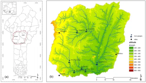
Fig. 1. (a)Benin with communal borders and Upper Ou´em´e catchment.(b)Upper Ou´em´e catchment with river gauges of CATCH-project
and Direction G´en´eral de l’Hydraulique used for model validation.
interdisciplinary assessment of future water availability and water consumption in the Ou´em´e catchment in Benin.
2 The Upper Ou´em´e catchment in view of global change
In Benin the IMPETUS-project focuses on the Upper Ou´em´e catchment, which has a size of 14 300 km2(Fig. 1). It is lo-cated in the sub-humid Sudan-Guinea-Zone in central Benin. This region is characterized by a unimodal rainy season from May to October with a mean annual precipitation of 1100 mm per year. The mean temperature is 26.4◦C. Due to
the lack of rainfall during the dry season the river discharge occurs only periodically from June to December.
The geomorphology of the catchment is characterized by a flat, undulating pediplain relief with altitudes from 227 to 616 m above sea level (Fig. 1). The region belongs to the pre-cambrian basement complex which is mainly composed of migmatite. The main soil types of the catchment are Lixisols and Acrisols according to the World Reference Base classifi-cation (ISSS Working Group RB, 1998). Near the rivers also hydromorphic soils occur. The vegetation is mainly com-posed of moist savannah. 14% of the catchment is actually used as field.
During the last decades global and regional change ef-fects were observed in the region. As a result of climate change precipitation decreases and the rainy season short-ens, which causes a reduction of river flow in the region, e.g. at the Ou´em´e-B´eterou river gauge (Speth et al., 2002). The land use/land cover change in the Upper Ou´em´e catch-ment was investigated by Judex (2003) comparing a land use/land cover classification from 1991 and 2000, derived from LANDSAT ETM+ data. According to this investiga-tion the land cover change is particularly high in the
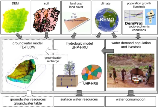
groundwater model FE-FLOW
Hydrologisches Modell UHP SIMULAT-H
climate population growth livestock
socio-economic conditions land use/
land cover
hydrologic model UHP-HRU
water demand population and livestock
groundwater resources groundwater table
soil DEM
groundwater recharge
surface water resources water consumption
Fig. 2.Interdisciplinary modelling approach to assess future water availability. Dashed lines: planned components.
3 Scenarios of regional development and climate change scenarios
In order to investigate the effects of global and regional change on the water resources scenarios of the regional de-velopment were evolved for Benin. Scenarios are consis-tent and plausible images of alternative futures that are rich enough to support the decision making process. A meaning-ful scenario shows different societal, ecological and techno-logical aspects of the system under investigation. Scenarios are not predictions and should not be qualified by a proba-bility. Instead, they allow for the analysis and assessment of alternative development paths of complex systems. The basic characteristics and the main driving forces, as well as their interactions are usually described in so-called narrative “storylines” (Speth et al., 2005).
The scenario building approach comprises seven steps starting with a problem analysis and the definition of the ba-sic scenarios and their main characteristics and scales (Speth et al., 2005).
To characterize the scenarios indicators and driving forces were determined and qualitatively described. For Benin three base scenarios were developed for the time period of 2000– 2025:
Scenario B1 “Economic growth and consolidation of de-centralization” describes a scenario of political stability and economic growth. Living conditions of the population im-prove and the overall pressure of resource depletion de-creases due to technical innovations.
Scenario B2 “Economic stagnation and institutional inse-curity” sketches a development path of a continuing and
mu-tually influencing spiral of political destabilisation and eco-nomic depression. Declining world market prices for the main export products, decreasing grants of donor assistance and declining rates of regional and local economic coopera-tion lead to a negative overall economic development which undermines also the political stability of the country. Liv-ing conditions worsen or stagnate on a low level. Resource depletion and resulting conflicts increase.
Scenario B3 “Business as usual” extrapolates the current trends. Against this background there is no general increase of economic development and social welfare. The country is successful in maintaining its political stability but fails in im-proving its position on the world markets and its overall com-petitiveness. Population growth continues to decline and the traditional power structures on the local level remain rather unchanged.
The scenarios are specified for each scenario region: the Upper, Middle and Lower Ou´em´e (Speth et al., 2005).
4 Modelling concept
To assess the effects of global change on the water re-sources an interdisciplinary modelling approach is applied. An overview of the modelling approach is given in Fig. 2. As shown in the figure the model UHP-HRU is used to calcu-late the hydrological processes. For a better representation of the groundwater flow it is planned to integrate the FEFLOW-model (WASY, 2004) in the approach. As the calibration of the model is not finished yet, the integration of the model is not yet realized.
In the scenario modelling process the time variant in-put parameters are calculated by other models, as shown in Fig. 2. The LUCC (Land use and cover change) modelling is performed with the model CLUE-S (Verburg et al., 2002) by the remote sensing research group of the IMPETUS project. The climate scenarios are calculated with the REMO model, which is nested in the General Circulation Model (GCM) ECHAM (see Sect. 4.3). To assess the future water consump-tion data of domestic water use of Hadjer et al. (2005) and Schopp (2004) are used in combination with demographic projections of Heldmann (2006) and INSAE (2004). The an-imal water need is calculated by Gruber and Kuhn (2006) based on agro-statistical data.
4.1 The hydrological model UHP-HRU 4.1.1 Model concept and parameterization
The lumped model UHP (Bormann and Diekkr¨uger, 2004), which was successfully tested for several sub-catchments of the Ou´em´e river, was modified to the spatial distributed model UHP-HRU. It is a conceptual model, which takes into account all relevant hydrological processes like evapotran-spiration, surface runoff, interflow, percolation, groundwater recharge etc. The model is composed of three linear stor-ages: the root zone storage, unsaturated zone storage and saturated zone storage. They are linked via percolation and capillary rise. The potential evapotranspiration is optionally calculated with Penman (1956), Turc (1963) or Priestley and Taylor (1972). For the computation of the surface runoff the SCS curve number approach is used (SCS, 1972).
The spatial discretization is carried out according to the hydrologic response units (HRUs) concept. To define these HRUs the catchment is subdivided into small sub-catchments with ArcHydroTools using a digital elevation model (DEM). A further subdivision in HRUs is performed by a superposi-tion with a soil and a land use map. According to this pro-cedure the Upper Ou´em´e catchment was subdivided in 526 sub-catchments and 3517 HRUs.
For the discretization of the Upper Ou´em´e catchment the DEM from the SRTM mission from the USGS (http://srtm. usgs.gov/) was used. The existing soil map for Benin (scale 1:200 000, Faure, 1977) contains no information about soil physical properties. In order to get the required soil data for
model parameterization analyses of soil physical properties for representative soil profile for each soil type were carried out in the Upper Ou´em´e catchment during the first and sec-ond phase of the IMPETUS-project (Junge, 2004; Giertz, 2004; Sintonjji, 2005). The vegetation parameters were taken from investigations in the Upper Ou´em´e catchment from Orthmann (2005) and Mulindabigwi (2005). Missing data were taken from Scourlock et al. (2001). These parame-ters were considered as constant for the scenario calculation. 4.1.2 Model validation
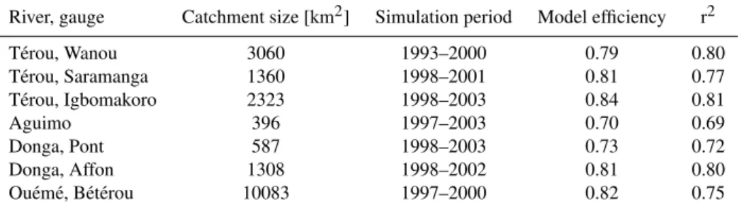
The model was tested in different sub-catchments of the Ou´em´e river for available discharge data of the period 1993– 2003. The lumped version of the UHP model was calibrated and validated using data from the T´erou-Wanou catchment (3133 km2; Bormann and Diekkr¨uger, 2004). A further cal-ibration of the distributed model was not required. As the model contains no routing routine the model validation of the distributed model was carried out in a weekly time step. As shown in Table 1 the model results are good for all sub-catchments. As the validation was performed in catchments with different land cover (Donga: high ratio of agricultural area, T´erou: mainly savannah and woodland), the applica-tion of the model for land use change scenarios is feasible. Due to the high inter and intra-annual variability of the rain-fall amount, the model has to deal with dry and wet condi-tions during the validation period. Therefore the model is also applicable for changing climate condition (e.g. reduc-tion of rainfall).
4.2 LUCC modelling
The LUCC modelling is performed by Thamm et al. (2005) with the cellular automata model CLUE-S (Verburg et al., 2002). The spatially explicit model was successfully tested in different tropical environments (Verburg et al., 2004; Verburg et al., 2004a).
The setup of the CLUE-S model requires probability lay-ers for each land-cover class, convlay-ersion information and fu-ture demand scenarios. Influences of different driving forces on land use and land cover were calculated with logistic re-gression in which the distance to roads, the distance to im-portant settlements, the population density, the soil suitabil-ity for agriculture and the protected forest areas are used as independent variables (Thamm et al., 2005).
Table 1. Quality measures of UHP-HRU application in the Upper Ou´em´e catchment (validation period). Discharge data used for model validation provided by the CATCH-project and Direction G´en´eral de l’Hydraulique.
River, gauge Catchment size [km2] Simulation period Model efficiency r2
T´erou, Wanou 3060 1993–2000 0.79 0.80
T´erou, Saramanga 1360 1998–2001 0.81 0.77
T´erou, Igbomakoro 2323 1998–2003 0.84 0.81
Aguimo 396 1997–2003 0.70 0.69
Donga, Pont 587 1998–2003 0.73 0.72
Donga, Affon 1308 1998–2002 0.81 0.80
Ou´em´e, B´et´erou 10083 1997–2000 0.82 0.75
cover classes (Thamm et al., 2005). Consequently the model is able to explain the land cover change in the region with the chosen driving forces.
The first scenario calculation for the period 2000 to 2025 was performed for the ‘business as usual’ scenario in a yearly time step. The output data are yearly land cover maps with a resolution of 500×500 m. An amelioration of the resolution
is in progress.
The generated land cover maps serve directly as input for the hydrological model.
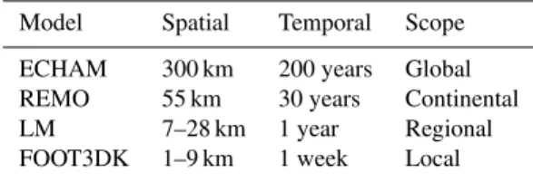
4.3 Climate modelling
The climate modelling in the IMPETUS-project is performed on different spatial and time scales with a chain of climate models, which serves as dynamical downscaling approach. Each smaller-scale model is nested in the coarser resolved one, receiving the atmospheric forcing from the coarser re-solved model (Paeth et al., 2005). The dynamic downscaling approach is used in IMPETUS because according to Paeth et al. (2005) the dynamic approach produces consistent data sets of all meteorological variables like rainfall, cloudiness, and humidity. On the global scale the GCM ECHAM is used. REMO is nested in the ECHAM-model and calculates the climatic processes on a spatial resolution of 0.5◦
×0.5◦.
REMO is a hydrostatic regional climate model developed at the Max Planck Institute of Meteorology. Rainfall data are post-processed and adapted to measurements using model output statistics (Paeth et al., 2005; Paeth, 20061). A further downscaling is performed with the LM (Lokalmodell) of the German Weather Service and the FOOT3DK model, which can be used for regional and local investigations. As the sce-nario calculation with theses local models is not finished yet, the results of the REMO model were used to calculate the future scenario in this study (Speth et al., 2005).
Sensitivity studies with REMO (Paeth, 2004) have re-vealed that land degradation plays an important role in the
1Paeth, H.: Statistical postprocessing of simulated precipitation
data for hydrological and climatological analyses in West Africa, Meteorol. Atmos. Phys., submitted, 2006.
atmospheric processes, especially in the Sahel and the Congo basin. Therefore, realistic climate predictions in Africa have to consider land degradation in addition to the greenhouse conditions. To calculate the scenarios with REMO the model was nested in the ECHAM 4 model with a quantification of greenhouse gases taken from IPCC scenarios. Additionally the large scale changes in land cover were implemented us-ing FAO data. The comparison of simulated and measured rainfall amounts in Benin has shown that REMO is able to compute realistic precipitation amounts for the region (Paeth, 2004; Paeth et al., 2005; Paeth, 20061). Using this approach five time slices (2005, 2010, 2015, 2020 and 2025) were cal-culated for the IPCC scenario B2 with REMO. Actually con-sortial runs with REMO are performed for the period 2001 to 2050 using the new IPCC scenarios A1b and B1 with ECHAM5 forcing. These data will be used in future for the scenario analysis with the presented modelling approach.
The results of the REMO model are available in a 0.5◦
×0.5◦grid. These data are directly used as input for the
hydrological model. 4.4 Water consumption
As there is no industry in the Upper Ou´em´e catchment the water consumption is restricted to household and agricul-tural water use. The regional survey of Hadjer et al. (2006) revealed that nearly no irrigation is performed in the catch-ment. As the water use of crops is implied in the hydrologic model, only household and animal water consumption has to be taken into account.
Table 2.Climate modelling chain within the IMPETUS-project.
Model Spatial Temporal Scope
ECHAM 300 km 200 years Global REMO 55 km 30 years Continental
LM 7–28 km 1 year Regional
FOOT3DK 1–9 km 1 week Local
depends particularly on access to water. Consequently the water consumption in the city is higher than in the village, where the water supply infrastructure is often very bad in central Benin.
The demographic data are obtainable from census data of INSAE (2003) for 1979, 1992 and 2002. For future sce-narios the regionalized demographic projections from Held-mann (2006) based on national projections of INSAE (2004) were used. The projections were calculated from 2002 (last census) to 2025 for the three development scenarios with the model SPECTRUM DEM-Proj (http://www.policyproject. com). The model determined only small differences in the population number for the different scenarios.
In the presented modelling approach the model BenIM-PACT of the Institute for Agricultural Policy, Market Re-search and Economic Sociology of the University of Bonn will calculate the water use of the livestock. As the develop-ment of the livestock module of BenIMPACT is not finished yet a calculation based on data of the agricultural statistic of Benin was used in combination with water consumption data (Gruber and Kuhn, 2006). For the scenario calculation the growth rate was taken from demographic projections.
5 First scenario results
A first test run of the modelling approach was performed for the Upper Ou´em´e catchment for the year 2025. In this first scenario analysis the development scenario B3 “business as usual” was combined with the IPCC climate scenario B2. As the calculation of the continuous climate scenarios and the development of all modelling tools are not finished yet, the following scenario results have to be considered as prelimi-nary.
For the development scenario B3 the LUCC modelling shows an increase of agricultural area and a decrease of dense and sparse savannah from 2000 to 2025 (Table 3). The spa-tial distribution reveals that the expansion of agricultural area occurs mainly along roads and tracks, where the accessibility is easy.
Concerning the IPCC scenario B2 the REMO model shows an increase of temperature and a decrease of rain-fall for the region. Compared with the mean precipitation from 1993–2003 the rainfall is 163 mm less in 2025
(Ta-Table 3.Land cover in the Upper Ou´em´e catchment 2000 and 2025, scenario “business as usual” (Thamm et al., 2006).
Land cover class [%] 2000 2025
Settlements 0.3 0.4
Agricultural area>55% 3.8 5.0 Agricultural area<55% 32.2 55.5
Forest 0.6 0.6
Dense savannah 24.9 14.7 Sparse savannah 38.2 23.9
ble 4). Due to a high interannual variability rainfall amounts of about 1000 mm occurred also during the last decades (e.g. 2001). Regarding all time slices the REMO simulation shows a trend of reduced rainfall in the future although for single years an increase compared to the long-term mean has been computed.
Figure 3 shows the comparison of the minimal, maximal and mean discharge at Ou´em´e-Beterou gauge from 1993– 2003, the measured discharge for the year 2000 and the simu-lated discharge with UHP-HRU for the scenario 2025. Com-pared to the mean discharge from 1993–2003 and the dis-charge of the year 2000 the disdis-charge period for 2025 is shorter. Striking is the reduction of discharge in the end of August, which does not occur in the period 1993–2003. This is caused by a strong reduction of precipitation in this period simulated by REMO. The comparison of measured and simulated rainfall for the period 1979–2003 revealed that the model tends to underestimate the rainfall in August (see Sect. 6, Fig. 7), which can also influence the scenario simu-lation.
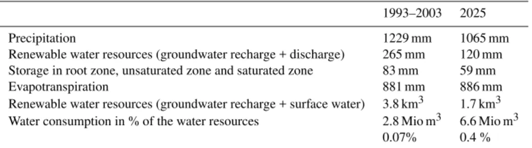
According to the scenario simulation the renewable water resources are halved in 2025 compared to 1993–2003 for the region (Table 4). The reduction mainly results from the cli-mate scenario input. The spatial distribution of the renewable water resources in 2000 and 2025 is shown in Fig. 4.
As only one time slice was calculated in this study no general conclusion concerning the further water availability can be drawn. Nevertheless, the results obtained here fit to other studies in that area. The study of Sintondji (2005) re-vealed that the general trend of decreasing discharge is also observable for the other time slices except for 2015. Sin-tondji computed discharge and erosion for a sub-catchment of the Ou´em´e river using the model SWAT in a much coarser resolution as considered here.
0 100 200 300 400 500 600
1.
1
1.
2
1.
3
1.
4
1.
5
1.
6
1.
7
1.
8
1.
9
1.
10
1.
11
1.
12
di
s
c
har
ge
[
m
³/
s
e
c
]
max 1993 - 2003
min 1993 - 2003
mean 1993 - 2003
year 2000
scenario 2025 600
0
100
200
300
pr
ec
ipi
tat
on [
m
m
]
Fig. 3.Minimal, maximal and mean discharge at the Ou´em´e-Beterou gauge and mean precipitation of the period 1993–2003 compared with discharge and precipitation of 2025 for scenario B3 combined with IPCC B2. Additionally the discharge of the year 2000 is displayed for a better comparability of the annual discharge dynamics.
Table 4.Water balance of the period 1993–2003 and the scenario B3 year 2025 simulated with UHP-HRU.
1993–2003 2025
Precipitation 1229 mm 1065 mm
Renewable water resources (groundwater recharge + discharge) 265 mm 120 mm Storage in root zone, unsaturated zone and saturated zone 83 mm 59 mm
Evapotranspiration 881 mm 886 mm
Renewable water resources (groundwater recharge + surface water) 3.8 km3 1.7 km3 Water consumption in % of the water resources 2.8 Mio m3 6.6 Mio m3
0.07% 0.4 %
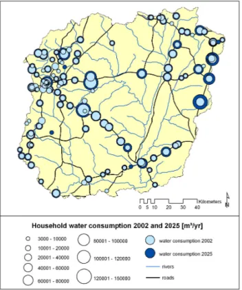
in the census is calculated (Fig. 5). Calculations of Gruber and Kuhn (2006) revealed, that the water need for livestock is four times higher in 2025 compared with 2002, which is not only caused by an augmentation of the livestock number but also by an increase of water consumption by the animals, due to higher air temperatures. The development of water consumption from 1992 to 2025 is displayed in Fig. 6. Also the total water consumption increases strongly, it represents only 0.4 % of the yearly water resources in the catchment (Table 4).
6 Discussion of uncertainties within the modelling ap-proach
Fig. 4.Renewable water resources in the Upper Ou´em´e catchment 2000 and scenario 2025 (development scenario B3 in combination with IPCC scenario B2).
Fig. 5. Household water consumption in the Upper Ou´em´e
catch-ment 2002 and scenario 2025.
As results from other models were used for the scenario calculation the uncertainty of these model results have to be taken into account in addition to the uncertainties of the hy-drological modelling.
0 1000 2000 3000 4000 5000 6000 7000
1992 2002 2025
10
00
m
³
water need livestock
houshold water consumption
Fig. 6. Development of water consumption in the Upper Ou´em´e
catchment.
The REMO model is a regional climate model with a grid size of 0.5◦
×0.5◦. The Upper Ou´em´e catchment is covered
0 50 100 150 200 250 300
jan feb mar apr may jun jul aug sep oct nov dec
[m
m
]
measured
REMO-simulation
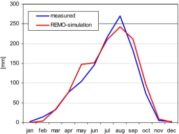
Fig. 7. Comparison of the measured rainfall of the rain gauge
Partago and the rainfall for the corresponding pixel of the REMO simulation (1979–2003).
intensities simulated from REMO differs from the measured rainfall intensities because the model computes mean rain-fall intensities over the grid. These uncertainties influence the modelled surface runoff and the simulated erosion rate, which was the focus of the study of Sintondji (2005).
As shown in Thamm et al. (2005) the LUCC model is able to explain the land cover change in the region with the cho-sen driving forces for the period 1991–2000. As a business as usual scenario was calculated in this study the uncertain-ties related to the land cover simulations can be assessed as relatively low. For further scenarios with a change of the eco-nomic development in the region (development scenarios B1 and B2) the estimation of the input parameters for the LUCC modelling will be more difficult as for the business as usual scenario. Therefore the uncertainty of these scenarios could be higher than for the scenario calculated here.
7 Conclusions
In the presented modelling approach the future water avail-ability and water consumption of the Upper Ou´em´e catch-ment is assessed in an interdisciplinary scenario analysis. With the combination of LUCC, climate, demographic and hydrologic modelling with water consumption investigations all impacts on the future water availability can be assessed. As different models were used in this approach the uncertain-ties of all models have to bee taken into account.
The test run of the coupled models shows that the ap-proach is applicable for an interdisciplinary scenario anal-ysis in Benin. For the calculated scenario (development sce-nario B3 “business as usual” combined with IPCC scesce-nario B2) a decrease of water resources in the region and an aug-mentation of water demand was calculated for the year 2025. But as only one year was calculated in this study no general
conclusion concerning the further water availability can be drawn. Even if the available water resources will be reduced as calculated in the scenario the region will not be subject to water scarcity considering the yearly water balance. The main problems concerning water availability in the region are the lack of renewable water in the dry season from December to April and the bad water supply infrastructure. Today over 60% of the population in some of the major communes of the Upper Ou´em´e catchment (Djougou, N’Dali and Tchaourou) has to use unsafe drinking water from rivers or unprotected wells.
Although the modelling and scenario concept described in this study is not able to solve these infrastructural problems, it can be an important step in the analysis and assessment of future water resource and establishes the basis of a sustain-able water management in the region.
Acknowledgements. The authors would like to thank the
Ger-man ministry of education and research (BMBF, grant No. 01 LW 0301A) as well as the MSWF Northrine-Westfalia (Grant No. 223-21200200) for the funding of the IMPETUS project in the framework of the GLOWA program. Thanks also to H.-P. Thamm and M. Judex, University of Bonn, for providing the land use classification of the Upper Ou´em´e valley. The climate simulations using the REMO model were provided by Dr. Paeth which is highly appreciated. The authors would also like to thank I. Gruber for providing the data concerning livestock water need. A special thank goes to the CATCH-project and the Direction G´en´erale de l’Hydraulique (DGH) in Benin, who provided the discharge and precipitation data for the Upper Ou´em´e catchment.
Edited by: R. Barthel, J. G¨otzinger, G. Hartmann, J. Jagelke, V. Rojanschi, and J. Wolf
Reviewed by: anonymous referees
References
Bormann, H. and Diekkr¨uger, B.: A conceptual, regional hydrolog-ical model for Benin (West Africa): validation, uncertainty anal-ysis and assessment of applicability for environmental change analyses, Phys. Chem. Earth, 29, 759–786, 2004.
Cosgrove, W. J. and Rijsberman, F. R.: World Water Vision. Making Water Everybody’s Business, World Water Council, Earthscan Publications, London, 2000.
Doevenspeck, M.: Migration im l¨andlichen Benin, Sozial-geographische Untersuchungen an einer afrikanischen Frontier, Studien zur Geographischen Entwicklungsforschung, 30, 313p., 2005.
Faure, P.: Carte p´edologique de Reconnaissance de la R´epublique Populaire du B´enin `a 1:200 000: Feuille Djougou, ORSTOM, Notice explicative no. 66(4), 49p., 1977.
Gaiser, T., Krol, M., Frischkorn, H., and de Ara´ujo, J.C. (Eds.): Global Change and Regional Impacts: Water Availability and Vulnerability of Ecosystems and Society in the Semiarid North-east of Brazil, Springer Berlin Heidelberg, 2003.
Benin, PhD-Thesis, University of Bonn, http://hss.ulb.uni-bonn. de/diss online/math nat fak/2004/giertz simone/index.htm, 2004.
Gruber, I. and Kuhn, A.: Land- und Wasserbedarf der Nutztier-haltung in Benin, IMPETUS, Sechster Zwischenbericht, 86– 90, http://www.impetus.uni-koeln.de/content/content En Pr Do. php, 2006.
Hadjer, K., Klein, T., and Singer, U.: Wasser und Existenz-sicherung, IMPETUS, Sechster Zwischenbericht, 198–206, http: //www.impetus.uni-koeln.de/content/content En Pr Do.php, 2006.
Hadjer, K., Klein, T., and Schopp, M.: Water consumption em-bedded in its social context, north-western Benin, Phys. Chem. Earth, Special Issue, Vol. 30, 6–7, 357–364, 2005.
Heldmann, M.: Demographische Projektionen f¨ur das Ou´em´e-Einzugsgebiet, IMPETUS, Sechster Zwischenbericht, 184–191, http://www.impetus.uni-koeln.de/content/content En Pr Do. php, 2006.
INSAE: Troisi´eme Recensement G´en´eral de la Population et de l’Habitat de F´evrier 2002. La population des communes de Tchaourou, N’dali, Parakou, Bassila, Djougou, Cotonou, Institut National de la Statistique et de l’Analyse Economique, Cotonou, B´enin, 2003.
INSAE: Troisi`eme Recensement General de la population et de l’habitation, Fevrier 2002, Tome 6: Projections d´emographiques et ´etude prospective de la demande sociale au B´enin, 2004. IPCC: Climate change 2001: The scientific basis, Contribution of
the working group I to the third assessment report of the inter-governmental panel on climate change, Cambridge, 2001. ISSS Working Group RB: World Reference Base for Soil
Re-sources: Atlas. Acco, Leuven, 1998.
Judex, M.: Analyse und Erkl¨arung der Landbedeckungs- und Landnutzungs¨anderung im Upper Oueme Catchment (Benin, Westafrika) durch die Verkn¨upfung von LANDSAT-Daten mit sozio¨okonomischen Daten, Diploma Thesis, Univer-sity of Bonn, http://www.rsrg.uni-bonn.de/RSRGwww/Deutsch/ Diplomarbeiten/Judex Diplomarbeit 2003.pdf, 2003.
Junge, B: Die B¨oden im oberen Ou´em´e-Einzugsgebiet: Pe-dogenese, Klassifikation, Nutzung und Degradierung, PhD-Thesis, University of Bonn, http://hss.ulb.uni-bonn.de/diss online/landw fak/2004/junge birte/index.htm, 2004.
Lahmer, W., Pf¨utzner, B., and Becker, A.: Assessment of land use and climate change impacts on the mesoscale, Phys. Chem. Earth, 26, 7–8, 565–576, 2001.
Legesse, D., Vallet-Coulomba, C., and Gassea, F.: Hydrological re-sponse of a catchment to climate and land use changes in Trop-ical Africa: case study South Central Ethiopia, J. Hydrol., 275, 67–85, 2003.
Mimikou, M. A., Baltas, E., Varanou, E., and Pantazis, K.: Regional impacts of climate change on water resources quantity and qual-ity indicators, J. Hydrol., 234, 95–109, 2000.
Mulindabigwi, V.: Influence des syst`emes agraires sur l’utilisation des terroirs, la s´equestration du carbone et la s´ecurit´e alimen-taire dans le bassin versant de l’Ou´em´e sup´erieur au B´enin, PhD-Thesis, University of Bonn, 2005.
Ojo, O., Oni, F., and Ogunkunle, O.: Implications of climatic variability and climate change on water resources availability and water resources management in West Africa, in: Water Re-sources Systems – Water Availability and Global Change, edited
by: Franks, S., Bl¨oschl, G., Kumagai, M., Musiake, K., and D. Rosbjerg, IAHS Publication, 280, 37–47, 2003.
Orthmann, B.: Vegetation ecology of a woodland-savanna mosaic in central Benin (West Africa): Ecosystem analysis with a focus on the impact of selective logging, PhD-Thesis, University of Rostock, http://www.impetus.uni-koeln.de, 2005.
Paeth, H.: Key factors in African climate change evaluated by a regional climate model, Erdkunde, 58, 290–315, 2004.
Paeth, H., Born, K., Podzun, R., and Jacob, D.: Regional dynamic downscaling over Westafrica: Model evaluation and comparison of wet and dry years, Meteorologische Zeitschrift, 14.3, 349– 367, 2005.
Penman, H. L: Evaporation: An introduction survey, Neth. J. AGR. Sci., 4, 8–29, 1956.
Pontius, R. and Schneider, L. C.: Land-use change model validation by the ROC method, Agriculture, Ecosystems and Environment, 85, 269–280, 2000.
Priestley, C. H. B. and Taylor, R. J.: On the assessment of sur-face heat flux and evaporation using large scale parameters, Mon. Wea. Rev., 100, 82–92, 1972.
SCS: Estimation of direct runoff from storm rainfall, National en-gineering handbook, Section 4 – Hydrology, USDA, 10.1–10.24, 1972.
Schopp, M.: Wasserversorgung in Benin unter Ber¨ucksichtigung sozio¨okonomischer und soziodemographischer Strukturen – Analyse der Wassernachfrage an ausgew¨ahlten Stan-dorten des Haute Ou´em´e, PhD-Thesis, University of Bonn, http://hss.ulb.uni-bonn.de/diss online/landw fak/2005/ schopp marion/index.htm, 2004.
Scurlock, J. M. O., Asner, G. P., and Gower, S. T.: Global Leaf Area Index Data from Field Measurements, 1932–2000, The Oak Ridge National Laboratory Distributed Active Archive Center, Oak Ridge, Tennessee, USA, 2001.
Sintondji, L. O.: Modelling the rainfall-runoff process in the Up-per Ou´em´e catchment (Terou in Benin Republic) in a context of global change: extrapolation from local to regional scale, Shaker Publisher, Aachen, 2005.
Speth, P., Diekkr¨uger, B., and Christoph, M.: IMEPTUS West Africa – An integrated approach to the efficient management of scarce water resources in West Africa, in: German Programme on Global Change in the Hydrological Cycle (Phase I, 2000– 2003), edited by: GSF – Forschungszentrum f¨rr Umwelt und Gesundheit, Status Report, 61–67, 2002.
Speth, P., Diekkr¨uger, B., Christoph, M., and Jaeger, A.: IMPETUS West Africa - An integrated approach to the efficient manage-ment of scarce water resources in West Africa. in: GLOWA – Global Change in the Hydrological Cycle, edited by: PT-DLR – Projekttr¨ager im DLR, Status Report 2005, 86–94, 2005. Thamm, H.-P., Judex, M., and Menz, G.: Modelling of Land-Use
and Land-Cover Change (LUCC) in Western Africa using Re-mote Sensing, Zeitschrift f¨ur Photogrammetrie und Fernerkun-dung, 3/2005, 191–199, 2005.
Turc, L.: Evaluation des besoins en eau d’irrigation, ´evapotranspiration potentielle, formulation simplifi´e et mise `a jour, Ann. Agron., 12, 13–49, 1963.
Verburg, P. H.; Voldkamp, W. S. A., Espaldon, R. L. V and Mas-tura, S. S. A.: Modeling the Spatial Dynamics of Regional Land Use: The CLUE-S Model, in: Environmental Management, 30, 3, 391–405, 2002.
Verburg, P. H., Overmars, K. P., and Witte, N.: Accessibility and land use patterns at the forest fringe in the Northeastern part of the Philippines, The Geographical Journal, 170(3), 238–255, 2004.
Verburg, P. H., Veldkamp, A., Engelsman, W., van Zalinge, R., van Mensvoort, M. E. F., and Overmars, K. P: The use of models to assess the impact of and use change on ecological processes: case-studies of deforestation in SE Asia, in: Land use, nature conservation, and the stability of rainforest margins in Southeast Asia, edited by: Gerold, G., Fremerey, M., and Guhardja, E., 475–494, 2004a.