www.biogeosciences.net/13/3427/2016/ doi:10.5194/bg-13-3427-2016
© Author(s) 2016. CC Attribution 3.0 License.
Variability in
14
C contents of soil organic matter at the plot and
regional scale across climatic and geologic gradients
Tessa Sophia van der Voort1, Frank Hagedorn2, Cameron McIntyre1,3, Claudia Zell1, Lorenz Walthert2, Patrick Schleppi2, Xiaojuan Feng1,4, and Timothy Ian Eglinton1
1Institute of Geology, ETH Zürich, Sonneggstrasse 5, 8092 Zürich, Switzerland
2Swiss Federal Research Institute WSL, Forest soils and biogeochemistry, Zürcherstrasse 111,
8903 Birmensdorf, Switzerland
3Department of Physics, Laboratory of Ion Beam Physics, ETH Zurich, Otto-Stern-Weg 5, 8093 Zurich, Switzerland 4State Key Laboratory of Vegetation and Environmental Change, Institute of Botany, Chinese Academy of Sciences,
Beijing 100093, China
Correspondence to:Tessa Sophia van der Voort (tessa.vandervoort@erdw.ethz.ch) Received: 20 December 2015 – Published in Biogeosciences Discuss.: 18 January 2016 Revised: 12 May 2016 – Accepted: 13 May 2016 – Published: 14 June 2016
Abstract. Soil organic matter (SOM) forms the largest ter-restrial pool of carbon outside of sedimentary rocks. Radio-carbon is a powerful tool for assessing soil organic matter dy-namics. However, due to the nature of the measurement, ex-tensive14C studies of soil systems remain relatively rare. In
particular, information on the extent of spatial and temporal variability in14C contents of soils is limited, yet this
informa-tion is crucial for establishing the range of baseline properties and for detecting potential modifications to the SOM pool. This study describes a comprehensive approach to explore heterogeneity in bulk SOM14C in Swiss forest soils that en-compass diverse landscapes and climates. We examine spa-tial variability in soil organic carbon (SOC)14C, SOC con-tent and C : N ratios over both regional climatic and geologic gradients, on the watershed- and plot-scale and within soil profiles. Results reveal (1) a relatively uniform radiocarbon signal across climatic and geologic gradients in Swiss forest topsoils (0–5 cm,114C=130±28.6,n=12 sites), (2)
simi-lar radiocarbon trends with soil depth despite dissimisimi-lar envi-ronmental conditions, and (3) micro-topography dependent, plot-scale variability that is similar in magnitude to regional-scale variability (e.g., Gleysol, 0–5 cm, 114C 126±35.2,
n=8 adjacent plots of 10×10 m). Statistical analyses have
additionally shown that114C signature in the topsoil is not significantly correlated to climatic parameters (precipitation, elevation, primary production) except mean annual temper-ature at 0–5 cm. These observations have important
conse-quences for SOM carbon stability modelling assumptions, as well as for the understanding of controls on past and current soil carbon dynamics.
1 Introduction
Soil organic matter (SOM) constitutes the largest terrestrial reservoir of carbon outside of that held in sedimentary rocks (Batjes, 1996). With on-going rapid changes in land use and climate, carbon stability within this reservoir may be subject to change (Davidson and Janssens, 2006; Melillo et al., 2002; Schimel et al., 2001; Trumbore and Czimczik, 2008). The processes that lead to both stabilisation or destabilisation of SOM, however, remain poorly understood (von Lützow et al., 2008; Schmidt et al., 2011; Trumbore and Czimczik, 2008). The existence of numerous biological and physicochemical processes that operate simultaneously confound our under-standing of, and ability to accurately model SOM dynamics (Lutzow et al., 2006).
Po-lach, 1977) aids in the elucidation of processes taking place on decadal scales, while natural14C decay can shed light on
processes that occur on timescales of centuries to thousands of years. Although a powerful tracer, it is presently not well established how the amplitude of 14C variations associated
with carbon turnover and storage are masked by spatial het-erogeneity. Soils are intrinsically highly heterogeneous over a range of spatial scales (Goovaerts, 1998), and effects of climatic, geological and topographical gradients as well as small-scale variability at the plot or pedon scale are often overlooked or generalized.While spatial variability in soils has been explored in the context of SOM compositional pa-rameters (Conen et al., 2004; Goovaerts, 1998; Grüneberg et al., 2010), systematic studies of its influence on14C
charac-teristics of SOM are lacking. Moreover, despite the high car-bon stocks in subsoils, deeper soil carcar-bon characteristics have been much less intensively compared to topsoils, and there-fore remain poorly understood, particularly in the context of
14C variability (Fontaine et al., 2007; Rumpel and
Kögel-Knabner, 2011).
In order to examine the temporal and spatial scales of14C variability in soils, we have investigated SOM14C signatures in depth profiles across diverse climatic, and geologic gra-dients, as well as over different spatial scales. These find-ings provide a framework for anticipating and accounting for spatial variability that are of importance in developing sampling, measurement and carbon-cycle modelling strate-gies. The broader goal is to provide the foundation for un-derstanding, and ultimately predicting, regional-scale SOM (in)stability based on radiocarbon characteristics.
2 Materials and methods
2.1 Study area and plot selection
The study area, which covers the entirety of Switzerland, is located between 46–47◦N and 6–10◦E with an accompa-nying elevation gradient between roughly 480 and 1900 m above sea level (a.s.l.). Within this geographic and altitu-dinal range, mean air temperature (MAT) and mean annual precipitation (MAP) varies from 1.3 to 9.8◦C and∼600 to 2100 mm yr−1, respectively (Etzold et al., 2014; Walthert et
al., 2003). Samples investigated in this study derive from the Long-term Forest Ecosystem Monitoring (LWF) network monitored and maintained by the Swiss Federal Research Institute of Forest, Snow and Landscape Research (WSL) (http://www.wsl.ch/lwf). The LWF sites are all located in mature forests and samples were collected during the 1990s and have been stored in containers of hard plastic (Innes, 1995). They encompass marked climatic and geologic gra-dients, yielding an array of different soil types (Fig. 1). Sup-plement regarding these sites (e.g. clay content and profile depth) can be found in Supplemental Table S1. The LWF-network was chosen because it features (i) archived samples
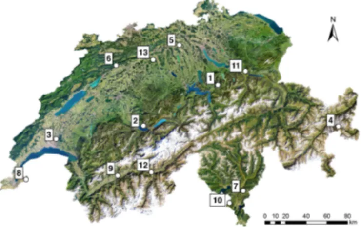
Figure 1. Locations of the sampled sites within Switzerland indicated by white points. Numbers refer to the locations
1Alpthal,2Beatenberg,3Lausanne,4Nationalpark,5Othmarsingen, 6Bettlachstock, 7Isone, 8Jussy, 9Lens, 10Novaggio, 11Schaenis, 12Visp and13Vordemwald (Innes, 1995).
(ii) environmental and ecological monitoring data and (iii) long-term monitoring and sampling potential. An overview of the most relevant lithological, geomorphic and climate variables of the sampled sites can be found in Table 1. Soils are classified in accordance with the World Reference Base (WRB, 2006).
2.2 Sampling methodology
Samples were taken in the course of the 1990s in a 43 by 43 m (∼1600 m2)plot, that was divided in quadrants of 20
meters (∼400 m2)and sub-quadrants of 10 m (∼100 m2),
each with 1 m of walking space in between (Walthert et al., 2002; Fig. 2a). For depth increments down to 40 cm soil of an area 0.5 by 0.5 m was sampled (0.25 m2), for samples
> 40 cm corers were used (∼2×10⁻³m2). Because differ-ent soil types were included, depth incremdiffer-ents rather than genetic horizons were analysed. In order to consider the plot-scale spatial variability, three mixing schemes were devised. 1. Eight discrete samples per depth were taken from the sub-quadrants according to a chessboard-pattern (Fig. 2a).
2. Sixteen samples per depth were taken from sub-quadrants, and combined and mixed for each quadrant of the plot (1–4, 5–8, etc), yielding in total four com-posite samples (Fig. 2b).
3. Sixteen cores are taken from sub-quadrants, all samples are combined and mixed to yield a single composite sample (Fig. 2a).
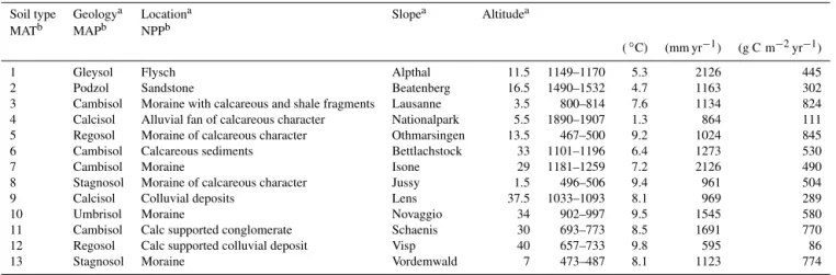
Table 1.Overview of WSL LWF sampling locations and main climate variables. Mean average air temperature (MAT) and mean average precipitation (MAP) and Net Primary Production (NPP) measured between 1980 and 2010. Numbers in first column correspond to site numeration of Fig. 1. Soil classification in accordance with WRB (2006), altitude in m a.s.l., soil and slope as a percentage of 90◦(Etzold et al., 2014; Walthert et al., 2003).
Soil type Geologya Locationa Slopea Altitudea
MATb MAPb NPPb
(◦C) (mm yr−1) (g C m−2yr−1)
1 Gleysol Flysch Alpthal 11.5 1149–1170 5.3 2126 445
2 Podzol Sandstone Beatenberg 16.5 1490–1532 4.7 1163 302
3 Cambisol Moraine with calcareous and shale fragments Lausanne 3.5 800–814 7.6 1134 824
4 Calcisol Alluvial fan of calcareous character Nationalpark 5.5 1890–1907 1.3 864 111
5 Regosol Moraine of calcareous character Othmarsingen 13.5 467–500 9.2 1024 845
6 Cambisol Calcareous sediments Bettlachstock 33 1101–1196 6.4 1273 530
7 Cambisol Moraine Isone 29 1181–1259 7.2 2126 490
8 Stagnosol Moraine of calcareous character Jussy 1.5 496–506 9.4 961 504
9 Calcisol Colluvial deposits Lens 37.5 1033–1093 8.1 969 289
10 Umbrisol Moraine Novaggio 34 902–997 9.5 1545 580
11 Cambisol Calc supported conglomerate Schaenis 30 693–773 8.5 1691 770
12 Regosol Calc supported colluvial deposit Visp 40 657–733 9.8 595 86
13 Stagnosol Moraine Vordemwald 7 473–487 8.1 1123 774
aWalthert et al. (2003),bEtzold et al. (2014).
1 2
4 3
5 6
7 8
43 m
43 m
A
10 m
1 2
3 4
5 6
7 8
9 10
11 12
13
15 14
16 43 m
43 m
B
10 m
Figure 2.Soil sampling scheme according to Walthert et al. (2002) at the Long-Term Forest Ecosystem (LWF) Research Program,
(a)eight individual samples taken in a chessboard pattern,(b)16 samples that are combined to mixed samples in each plot quadrant, as indicated by the red boxes (1–4, 5–8, etc).
Soil samples were dried in an oven at 35–40◦C, sieved through 2 mm, and stored in a climate controlled storage fa-cility at the WSL. In order to determine the density of the fine earth, volumetric samples were sampled in single profiles. These samples were taken using steel cylinders of 1000 cm3
volume (for layers with a thickness of at least 10 cm) or 458 cm3volume (for thin layers with less than 10 cm
thick-ness). Volumetric samples were dried at 105◦C for 48 h min-imum until the resulting mass remained constant. The den-sity of the fine earth was determined based on oven-dried volumetric soil samples and sieving the samples in a water bath to quantify the weight of stones > 2 mm. The volume of stones was calculated by assuming a density of 2.65 g cm−3
for stones (Walthert et al., 2002).
Variability within and between two similarly sized plots was investigated in a subalpine spruce forest in the Alp-tal Valley (central Switzerland), separated by approximately
500 m. The plots are located within the same watershed and hosted on the same bedrock and are primarily distinguished by their degree of tree coverage.
The two plots concerned are the following: (1) WSL LWF plot (∼1600 m2, sampled 1998), covered mainly by
Nor-way Spruce trees. Sampling was done by depth-increment in a 10×10 m grid (Fig. 2b); (2) WSL NITREX
con-trol plot, (∼1500 m2, sampled 2002) with a relatively open
tree canopy with well-developed herbaceous vegetation and shrubs (Schleppi et al., 1998). This site was sampled by hori-zon (litter, topsoil and Gleyic horihori-zon) on an 8×8 m grid,
yielding 24 soil cores. These cores were grouped according to their morphology.
Interpolation based on documented soil cores was used to convert the NITREX control plot horizon-logged cores to depth-logged cores.
2.3 Elemental,13C and14C analysis
Vapour acidification (12 M HCl) of soils in fumigated silver capsules was applied to remove inorganic carbon in the sam-ples (Komada et al., 2008; Walthert et al., 2010). Carbonate-poor samples were acidified for 24 h at room temperature, for carbonate-rich samples this treatment was extended to 72 h at a temperature of 60◦C. Both acidification treatments were tested on the same sample and no significant effect on the radiocarbon values was found. To ensure the removal of all carbonaceous material,δ13C values of the soil samples were measured. All glassware and silver capsules were combusted at 450◦C (6 h) prior to use.
MI-CADAS (MIniturised radioCArbon DAting System) at the Laboratory of Ion Beam Physics, ETH Zürich (Wacker et al., 2010). Samples were calibrated against oxalic acid II (NIST SRM 4990C) and an house anthracite coal as well as an in-house soil standard (Aptal soil 0–5 cm). Intra-sample (Alptal soil 0–5 cm) repeatability is high with a value and standard deviation of Fraction Modern (Fm)=1.1263±0.0003696
(n=12).
An Elemental Analyser-Isotope Ratio Mass Spectrome-ter system (EA-IRMS, Elementar, vario MICRO cube – Iso-prime, Vison) was used to measure the absolute concentra-tions of carbon and nitrogen, as well as stable carbon isotopic composition (δ13C). Calibration standards used for the C and
N concentrations, and C : N ratio were peptone (Sigma) and atropine (Säntis) and only atropine (Säntis). The δ13C
val-ues were used to assert that all inorganic carbon has been removed by the procedure, as well as provide a confirmation of the signature of the plant input.
2.4 Turnover model and statistical analysis
For the turnover time or mean residence time (MRT) esti-mates the system was assumed to be in steady state, with no time lag between atmospheric carbon fixation by plants and conversion to soil carbon. A time-dependent model (Eq. 1) (Herold et al., 2014; Torn et al., 2009) was used in combi-nation with atmospheric data of Levin et al. (2010). Here,
k refers to the decomposition rate constant andλto the ra-dioactive decay constant of14C in yr−1(1/8267).R
sampleis
inferred from114C as shown in Eq. (2) (Herold et al., 2014; Solly et al., 2013).
Rsample=k×Ratm,t
+(1−k−λ)×Rsample ( t-1 ) (1)
Rsample=
114Csample
1000 +1 (2)
MRT was calculated for the samples for which the signal was above the atmospheric114C signal of the sampling year, in-dicating a predominant input of post-bomb derived carbon. The constantkis found by matching the modelled and
mea-sured values of Eq. (1), and MRT is obtained by inverting
k(Torn et al., 2009). For the 0–5 cm topsoil layer two MRT
were frequently possible, in which case it was assumed the true MRT value of the deeper layer is the one that exceeds the MRT value of the accompanying litter layer, as carbon turnover rates decrease with increasing soil depth.
Statistical analyses were performed in R, version 3.1.2. Spatial variability of 14C was quantified by calculating the coefficient of variation (CV) of the Fm 14C values. The Fm values rather than the 114C values were used as CV tends toward infinity if the average value of the variable concerned nears to zero, which in this case would cause unwanted bias
(Stuiver et al., 1997). Drivers of CV were analysed by Pear-son correlation (rcorr function; hmisc package) using ancil-lary climate and geographic data taken from the WSL LWF network (Walthert et al., 2003). Ancillary data entailed MAT, MAP, net primary production (NPP), pH and mineralogical composition such as clay, sand and silt content. The Spear-man correlation coefficient (rcorr function; hmisc package) was used to test relationships between Fm and climatic and compositional parameters for data from separate depth inter-vals. The effects of climate and soil properties on radiocar-bon (114C) was also tested by fitting mixed-effect models by maximum likelihood (lme function; nlme package; (Pin-heiro and Bates, 2000). Mixed-effect model analyses provide an additional benefit because they eliminate variance intro-duced by random variables, whereas this is lacking in e.g. the Spearman correlation. For the mixed-effect model, the complete data set was used, i.e. all depths, soil cores and all individual depths were included. The variables site and core were always taken to be random effects following the sam-pling design at the LWF sites. Environmental drivers (MAT, MAP, NPP, pH, clay content) were taken as fixed effects and tested individually. The compositional parameters (e.g. clay, pH) are depth interval-specific. For the analysis concerning all depths,114C was tested against depth and the additional parameters. For set depth intervals,114C was related only to one parameter per analysis. In all final models, normality and homoscedasticity of the residuals were verified visually with diagnostic plots; the dependent variables were all log transformed in some cases to meet assumptions of normality and variance homogeneity. Semivariograms (variog function; geoR package) were also used to assess the patterns of vari-ability with distance.
3 Results
Spatial variability was systematically investigated from the regional (100–300 km) to the plot (10–100 m) scale.
3.1 Regional scale (100-300 km) variability
At the LWF sites across Switzerland (Table 1), the standard deviation in 114C values of the organic (LF) (n=12), 0–
5 cm (n=12) and 5–10 cm (n=11) layers exceeds the
in-strumental error by up to tenfold with values of 36.4, 28.6 and 34.9 ‰, respectively (Table 2). Furthermore, the coeffi-cient of variation in SOC content increases with depth whilst
114C variability remains almost constant (Fig. 3). The MRT relative error remains constant with depth (Table 2). For the former and latter analyses, a Podzol site (Beatenberg) was excluded because its unique thick organic layer distorted the topsoil age. The Spearman coefficient identified few signif-icant correlations between 114C in samples and climatic variables. Exceptions include a negative correlation between
0 20 40 60
0 50 100 150 200 250
Δ14C
0–5 cm
5–10 cm Organic layer
SO
C
(
%
)
Figure 3. Relationship of114C vs. soil organic carbon content (SOC) on the regional scale within Switzerland (n=12 sites), with
each sample representing the average of four cores covering an area of 400 m2. Samples were taken in between 1995 and 1998. Trends show decreasing variability of soil organic carbon content with depth, but no significant changes in the variability of114C contents with soil depth. Analytical errors are smaller than symbol sizes and are not visible (between 6–8 ‰114C).
Table 2. Overview variability of 114C and standard deviation across regions and horizons converted to mean residence time (MRT) and coefficient of variation (CV).
LF (n=12) 0–5 cm (n=12) 5–10 cm (n=10)
114C 159±36.4 130±28.6 67.4±35.9
Fm 1.17±0.037 1.14±0.029 1.08±0.035
CVFm 0.031 0.025 0.033
MRT (yr) 7.58±3.5 66.9±23 143±57
CVMRT (yr) 0.46 0.34 0.40
SOC (%) 37.93±11.4 11.68±7.26 6.40±4.66
CVSOC (%) 0.30 0.62 0.73
samples and a positive correlation between114C and relief
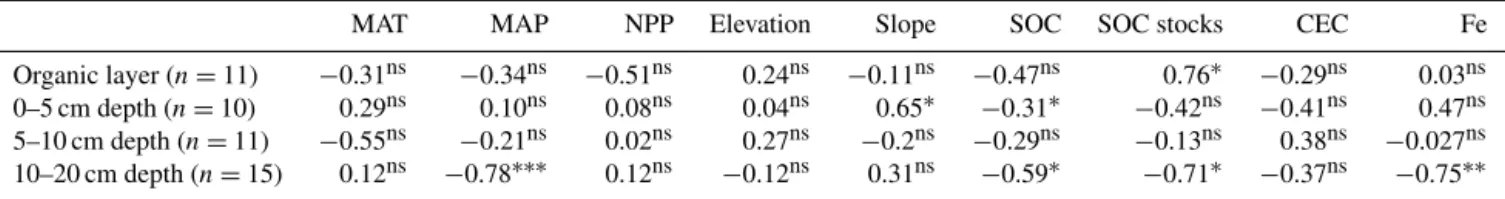
(slope) in samples from 0 to 5 cm depth. Furthermore, Spear-man correlation does indicate a significant positive correla-tion between 114C and SOC stocks in the 0–5 cm mineral soil, and conversely a significant negative correlation in the 10–20 cm depth interval. There was no significant correlation between114C and Cation Exchange Capacity (CEC), but a significant negative correlation between 114C and Fe con-tent in the 10–20 cm depth interval (Table 5). Mixed-effect models reveal few significant effects of environmental vari-ables on114C at the 12 LWF sites except SOC (but not at 5–10 cm) and MAT and Fe content at the 0–5 cm depth inter-val (Table 6).
-5
0
5
10
15
20
25
-300 -200 -100 0 100 200 300
0 10 20 30 40 50
Δ14C
Gley horizon (10-25 cm) A horizon (5-17 cm) Alptal NITREX site
organic layer
C:N ratio C:N
-5
0
5
10
15
20
25
-300 -200 -100 0 100 200 300
0 10 20 30 40 50
Δ14C
0-5 cm
5-10 cm Alptal LWF site
de
pt
h
(c
m
)
10-20 cm
C:N ratio C:N
A
B
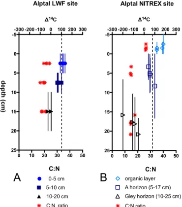
Figure 4.Intra-forest variability(a)four samples each taken from an area of approximate 400 m2, totaling to 1600 m2(b)four sam-ples representing micro-topographic end members sorted by hori-zon covering around to 1500 m2. The vertical bars represent the depth intervals. The dashed line indicates the114C signature of the atmosphere at the time of sampling in resp; 1998(a)and 2002(b)
(Hua et al., 2013).
3.2 Plot-scale (10-100 m) variability
In the subalpine spruce forest (Gleysol, Alptal catchment) two similarly sized plots were compared to assess inter-plot and intra-forest variability. Results show essentially similar ranges and trends with soil depth for both sites, both in terms of14C and C : N ratio. In the deeper soil horizons, the NI-TREX site has generally lower but also more variable114C values and slightly lower C : N ratios. Due to the differences in horizon vs. depth sampling procedures further statistical analysis is however not possible (Fig. 4).
0 10 20 30 40 50
-100 0 100 200
Δ14C
Mixed samples 400 m2 Mixed sample 1600 m2 Statistical average
Cambisol
Single samples
0 10 20 30 40 50
-100 0 100 200
Δ14C
Mixed sample 1600 m2 Mixed samples 400 m2
Statistical average Podzol
Single samples
SO
C
(
%
)
0 10 20 30 40 50
-100 0 100 200
Δ14C
Statistical average Mixed samples 400 m2
Gleysol
Single samples
r2 = 0.60
r2 = 0.00
r2 = 0.78
Figure 5.Relationship of114C vs. soil organic carbon (SOC) content in topsoil samples (0–5 cm) from three sites with decreasing micro-topographic relief from left to right. Error bars indicate analytical error. The pattern shows that single samples can be unrepresentative but careful physical homogenization of soil samples yields almost identical values than the arithmetic average of individual samples. The dashed vertical line in black indicates the114C signature of the atmosphere at the time of sampling (Hua et al., 2013). The dotted lines represent the linear regression of114C and SOC contents for single sample measurements.
10×10 m (Fig. 2), ranges from 50 ‰ (relative highest
de-gree of variability scenario, Podzol) to 20 ‰ (relative low-est degree of variability, Cambisol) (Table 3). In Supple-ment Fig. S1 the micro-topography is shown using digital terrain mapping-derived curvature data. Slope is positively correlated with the fraction modern coefficient of variation (CVFm)of single cores for the three high-resolution
(Cam-bisol, Gleysol, Podzol) sites (r2=0.99 forn=3). The SOC
concentration in the single cores of the Cambisol and Pod-zol correlate positively with114C signature (resp.r2=0.78,
n=7 andr2=0.60,n=8), but for the Gleysol there is no
correlation (r2=0.00) (Fig. 5). Pearson correlation between
variability (expressed as CVFm)and both environmental
vari-ables (MAT, NPP, Elevation, Slope, SOC content, C : N ratio) yielded weak correlations (r<0.35), except for clay content (r=0.71) and MAP (r=0.51).
In order to assess the efficacy of mixing of samples to achieve representative samples, four composite samples from the quadrants were measured (each ∼400 m2) as well as a composite of 16 samples (encompassing the entire plot,
∼1600 m2)as shown in Fig. 5. For the Cambisol and Pod-zol, the difference in114C values between physically mixed bulk samples and the statistical average of individual sam-ples is close to or within analytical uncertainty (resp. 15.1 and 0.46 ‰, Fig. 5) and considerably smaller than the stan-dard deviation of the quadrant samples. Semi-variograms did not yield satisfactory results, as the variance did not plateau on the involved spatial scales.
Table 3. Intra-plot variability for three spatial variability end-members, expressed in114C and standard deviation across regions and horizons converted to mean residence time (MRT) and coeffi-cient of variation (CV). Variability is the highest for the Podzol and Gleysol, and lowest for the Cambisol.
Podzol 0–5 cm Gleysol 0–5 cm Cambisol 0–5 cm
(n=7) (n=8) (n=8)
114C (‰) −1.48±43.26 126±35.2 129±18.5
Fm 1.00±0.047 1.13±0.038 1.35±0.020
CVFm 0.047 0.033 0.018
MRT (yr) – 73.0±27 2.64±2.1
CVMRT – 0.37 0.78
3.3 Influence of micro-topography and waterlogging on14C variability
The assessment of within-plot variability related to micro-topography was investigated at the NITREX plot. Cores were grouped according to morphological characteristics of the terrain:
1. Mounds (relative elevation up to 50 cm) with deeper wa-ter table, with a mor-type organic layer and an oxic Gley horizon.
-300-200-100 0 100 200 300 Δ14C
mound
Microtopography end-members
-10
0
10
20
30
0 10 20 30 40
SOC (%)
mound
de
pt
h
(c
m
)
12 14 16 18 20
C:N
C:N ratio mound C:N ratio strong depress weak depression
mixed type strong depression
mound
Figure 6.Variability in SOC,114C and C : N values between sep-arate micro-topography end-members (0–25 cm depth, in three in-tervals) of soils from the Alptal Valley. Weak depressions yield the lowest114C values, whilst the mounds are most enriched in14C. Analytical errors are smaller than symbol sizes and are not visible (between 6–8 ‰114C). The dotted vertical line for114C indicates the atmospheric input at the time of sampling (2002) (Hua et al., 2013).
3. Stronger depressions (relative depression up to 25 cm) with a very shallow water table, an anmotype or-ganic layer and underlying soil that is characterized by an anoxic Gley horizon.
4. Intermediate type (between type 1 and 2) with flat top, intermediate water table and anoxic Gley horizon. In Fig. S2 the micro-topography is shown using digital el-evation mapping data.
Radiocarbon data combined with SOC contents and C : N ratios show (Fig. 6) that (1) contrasts exist between soils de-veloped under different microtopographic features with the mound (oxic Gley) having the highest 114C value in the gley layers, indicating a higher degree of incorporation of organic matter containing bomb-derived radiocarbon. The strong (anoxic Gley) and intermediate depression (partially anoxic Gley) exhibit very similar radiocarbon signal in the organic layer, but with depth showing increasingly lower
114C values on the mound, with the weak depression being
the most 14C depleted in the Gley.114C values for the
in-termediate soil type falls between mounds and depressions. Additionally (2) SOC concentrations are higher in the top-soil of the mounds, but a reversed trend occurs at greater depth where the weak depression has higher SOC contents in the Gley horizon. Lastly (3) C : N ratios show a similar reversal, as the weak depression has a markedly lower C : N value than the other micro-topographic features in the top-soil, while having a higher value in the gleyic horizon.
0.1 1 10
100-300 -200 -100 0 100 200
Δ14C
Δ14C Gleysol 0–5 cm
Δ14C Podzol 0–5 cm
Δ14C Podzol 5–10 cm
Δ14C Podzol 10–20 cm
Δ14C Cambisol 0–5 cm
Δ14C Cambisol 5–10 cm
Δ14C Cambisol 10–20 cm
Δ14C Gleysol 5–10 cm
Δ14C Gleysol 10–20 cm
Δ14C Regosol 0–5 cm
Δ14C Regosol 5–10 cm
Δ14C Regosol 10-20 cm
Δ14C Calcisol 0–5 cm
Δ14C Calcisol 5–10 cm
Δ14C Calcisol 10–20 cm
SO
C
(%
)
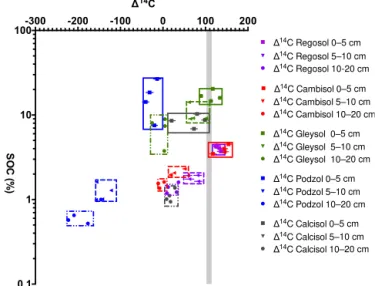
Figure 7.Spatial variability with depth (composites of each four cores, covering 400 m2)for five different soil types (Regosol, Cam-bisol, Gleysol Podzol and Calcisol) covering a gradient in eleva-tion and average air temperature (MAT 9.2–1.3◦C, elevation 800– 1900 m). The114C signature of atmospheric input at the time of sampling in indicated by grey shading (Hua et al., 2013). Variabil-ity in radiocarbon contents persists with depth and overlaps among soil types, while carbon contents differ among soil types and differ-ences decrease markedly with depth.
3.4 Spatial variability with depth
In order to establish14C variability as a function of depth
in topsoils, four composite soil samples (designed to assess within-plot spatial variability, each composed of four sub-cores from ∼400 m2, that encompass a total plot area of ∼1600 m2, Fig. 2) were examined for five sites, each
com-prising different soil types, at three depth intervals (0–5, 5– 10 and 10–20 cm) (Fig. 7). These analyses revealed that spa-tial variability, expressed in SOC content and114C, is more muted but persists at depth. For the four 400 m2 compos-ites, the standard error of spatial variability is only 1–3 times the analytical error, with the exception of the highest vari-ability end-member (Podzol). The use of composite samples helps in reducing the potential for anomalous and unrepre-sentative values (Figs. 5, 7). For examination of deeper soils (> 20 cm), samples taken along a single profile per site were measured (Fig. 8). Results show that regardless of marked differences in soil type (and associated processes that influ-ence SOM) and large climatic gradients, the depth gradient in
14C and overall amplitude of114C variations are remarkably
-20 0 20 40 100 200 300 400
0 1 2 3 4 5 20 40 60
SOC (%)
Depth (cm)
-900 -600 -300 0 300
Δ14C
0 10 20 30 40
C:N Gleysol Podzol Stagnosol Calcisol Cambisol
Figure 8.Soil organic carbon (SOC) content,114C and C : N ra-tios for five depth profiles of distinct soil types (Cambisol, Podzol, Calcisol, Stagnosol and Gleysol) covering a climatic and altitudinal gradient. Radiocarbon trends are highly similar for four out of five soil types, while carbon content and C : N ratio varies for each soil type. The Podzol shows a different trend, with114C consistently lower in the topsoil. Analytical errors are smaller than symbol sizes and are not visible (between 6 and 8 ‰114C).
one standard error (Fig. 8). Regressing the114C values with soil depth to 100 cm depth showed tight linear relationships (r=0.93–0.99). The depth gradients ranged between−3 and −8.5 ‰ cm−1for the five sites, but showed no consistent
re-lationship with any of the environmental variables (Table 1). The standard deviation associated with the SOC content and C : N ratios at these three locations also exceeds the values for these parameters in the five profiles. Additionally, with the exception of high-variability end-member Podzol, vari-ability of14C values with depth exceeds lateral variability for
the intervals 0–20 cm.14C variability with depth for deeper
soils (> 20 cm) exceeds lateral variability for all soil types (Table 4).
4 Discussion
4.1 Uniformity in14C signature across geological, climatic and depth gradients
Understanding the inherent stability and resilience of SOM in different climates is key for predicting how the carbon cy-cle may respond to future changes. The uniformity in topsoil radiocarbon signatures across the 12 sites spanning marked climatic and geological gradients as well as soil types im-plies that the MRT of SOM in different ecosystems is rel-atively similar despite dissimilar environmental conditions. Few significant relationships emerged from comparison of
114C values with environmental characteristics of the LWF sites (Tables 5 and 6). The significant positive correlation be-tween MAT and114C for 0–5 cm depth found in the mixed-effect model (Table 6) indicates that the speed of incorpo-ration of bomb carbon is positively related to MAT, which is consistent with the findings of Leifeld et al. (2015) in
grassland soils. However, the lack of correlation in the or-ganic layer and deeper layers indicate that confounding fac-tors such as variable ages from above- and belowground lit-ter input (Solly et al., 2013; Schrumpf et al., 2013) may im-pact the114C signal. The strong negative Spearman correla-tion of114C and MAP at 10–20 cm depth implies a slower turnover that could potentially be caused by increased wa-terlogging or anoxic conditions induced by higher precipita-tion. The significant positive correlation between114C and SOC stocks may be indicative of soil layers that retain car-bon for longer (higher stocks) and therefore contain higher fractions of bomb-derived14C entering the atmosphere from
the 1950s onwards, as opposed to soils with lower stocks which may have already lost the highly 14C labelled
car-bon. The significant negative correlation of 114C and SOC
stocks at 10–20 cm depth may reflect dilution of bomb-14C
derived carbon or delayed transmission of carbon containing the bomb-14C signal in SOC-rich soils. Similarly, the
nega-tive correlation between114C and iron content may indicate that iron may contribute to carbon stabilisation and hence smaller114C value, which is consistent with recent findings of Schrumpf et al. (2013) and Herold et al. (2014). The posi-tive relation between114C and relief (slope) for the shallow-est (0–5 cm depth) samples may be due to erosion-induced higher turnover rates that result in higher incorporation of bomb-derived material. The lack of significant correlation between114C and precipitation and primary production
in-dicates that the incorporation of carbon in soils is not consis-tently dependent on these climatic factors. This is consistent with findings of Doettler et al. (2015) that found that factors other than climate exert strong controls on carbon stocks. It has to be noted that the former study concerned stocks only (i.e. not turnover), but in a steady state system it is reason-able to assume slower turnover is coupled to larger carbon stocks. Mathieu et al. (2015) also found that the carbon dy-namics in deeper soils are not controlled by climate but rather by pedological properties, whereas topsoil carbon dynamics were observed to be related to climate and cultivation. Fur-thermore, the high overall similarity in radiocarbon profiles with depth for five strongly contrasting soil types implies that this similarity persists with depth. The limited size of the data set prohibits more rigorous statistical analyses. This uniformity also indicates an insensitivity of 14C in SOM to
environmental conditions. One explanation for this apparent insensitivity could be that C input into soils and decomposi-tion are driven by similar factors; for instance increased litter input with increasing MAT is accompanied by an increased decomposition rate. Furthermore, the presence of soil fauna (earthworms) at some sites with mull or modern type organic layer (Bettlachstock, Schaenis, Lausanne, Alptal, Visp and Novaggio) may also complicate the response of carbon cy-cling to climate due to bioturbation (Ernst et al., 2008).
The114C value for the Podzol in the topsoil is lower than for all other sites, which may be due to the unusually thick (> 20 cm) organic layer, which delays the transfer of the14C
signal to the mineral soil. The erratic behaviour below 1 m depth in the Cambisol (Lausanne) may be derived from a mixture of syn-glacial and post-glacial carbon present in the moraine underlying the soil. The relatively small variability at the regional scale was even more striking as the corre-sponding CV was almost the same as at the plot scale for soil samples located approximately 10 m apart from each other (Table 3).
There are only a few comparisons of 14C characteris-tics among soil types, but other studies have reported sim-ilar trends to those shown in Fig. 8 (Baisden and Parfitt, 2007; Jenkinson et al., 2008). Scharpenseel and Becker-Heidelmann (1989) however, find very different14C ages
be-tween soil types for the depths 20, 50 and 100 cm on differ-ent contindiffer-ents. Mills et al. (2013) analysed literature data for forest top soils and found a similar range in values to our samples. When comparing to cultivated soils we found large differences in 114C signature at depth (Paul et al., 1997). The variable time-point and horizon-notation of other soil radiocarbon samplings limit further comparison to existing literature (Eusterhues et al., 2007; Paul et al., 1997; Rumpel and Kögel-Knabner, 2011; Scharpenseel et al., 1989). The time of soil formation may be paramount to the differences that develop in the bulk14C age of organic carbon over time. Soil formation for the soils studied here initiated after the last glacial retreat and can hence be assumed to have started to form simultaneously, which may explain the similarity in their14C distribution with depth. Overall, the high
similar-ity of114C signatures between disparate soil types even at
depth indicates that the relative independence on tempera-ture and primary production may persist in deeper soils, and hence also for older SOM and during long-term C storage.
Further insights into the stability and vulnerability of SOM will likely require investigations of specific fractions (Schrumpf et al., 2013) and compounds (Feng et al., 2008), where contrasts in the dynamics of SOM will likely be am-plified. Soil carbon turnover and stability models (e.g. CEN-TURY, Yasso, SoilR) that are highly dependent on input parameters would also greatly benefit from improved esti-mates of spatial variability in14C and other properties at the plot and regional scale, in combination with site-specific bio-chemical data (Liski et al., 2005; Schimel et al., 2001; Sierra et al., 2014).
4.2 Plot-scale variability and the influence of micro-topography
The marked plot-scale variability in 14C revealed in this
study is similar in magnitude to 14C signal variations
Table 5.Spearman correlation of114C vs. climatic variables. Significant correlations are found between114C against MAP and SOC at 10–20 cm. For pvaluesp<0.05,p<0.005 andp<0.0005, values correlations are indicated with∗,∗∗and∗∗∗,p>0.05 is indicated with superscript “ns”. Cation Exchange Capacity (CEC) in mmol kg−1was calculated as defined by Blume et al. (2002). Iron (Fe) content
determined by HNO3extraction in (mg kg−1) (Walthert et al., 2003).
MAT MAP NPP Elevation Slope SOC SOC stocks CEC Fe
Organic layer (n=11) −0.31ns −0.34ns −0.51ns 0.24ns −0.11ns −0.47ns 0.76∗ −0.29ns 0.03ns
0–5 cm depth (n=10) 0.29ns 0.10ns 0.08ns 0.04ns 0.65∗ −0.31∗ −0.42ns −0.41ns 0.47ns
5–10 cm depth (n=11) −0.55ns −0.21ns 0.02ns 0.27ns −0.2ns −0.29ns −0.13ns 0.38ns −0.027ns 10–20 cm depth (n=15) 0.12ns −0.78∗∗∗ 0.12ns −0.12ns 0.31ns −0.59∗ −0.71∗ −0.37ns −0.75∗∗
Table 6.Results of the mixed effect model testing114C for the effects of environmental variables. Site and core were always taken as random effects, whilst log(SOC), Elevation, MAT, MAP NPP, pH and log(Clay) are taken separately as fixed effects. The table shows F-values and significant effects are indicated are indicated with∗,∗∗and∗∗∗forpvaluesp<0.05,p<0.005 andp<0.0005.p> 0.05 are indicated with superscript “ns”.
Log(SOC) Elevation MAT MAP NPP pH H20 Log(Clay) CEC SOC stocks Fe
0–5 cm (n=12 sites,n=39 samples) 5.7∗ 3.8ns 4.9∗ 0.11ns 0.97ns 0.39ns 0.54ns 0.25ns 0.0055ns 7.9∗
5–10 cm (n=4 sites,n=15 samples) 0.23ns 2.3ns 1.1ns 0.27ns 1.5ns 0.34ns 1.3ns 1.6ns 0.51ns 4.0ns
10–20 cm (n=5 sites,n=20 samples) 14∗∗ 0.41ns 0.12ns 0.64ns 0.53ns 0.43ns 0.32ns 0.0060ns 54∗∗∗ 0.0031ns
then will we be able to incorporate these factors in larger-scale models of SOM turnover. We find a positive correla-tion between 114C and SOC content when examining the 0–5 cm intervals for individual samples from the 10×10 m
sub-quadrants (Fig. 5). When looking at the variability be-tween composite cores at 0–5 and 5–10 cm, this relationship disappears and re-appears only at 10–20 cm depth (Fig. 8). However, the relationship between 114C and SOC differed among sites, indicating that other factors than C pool size contributed to the small-scale variability (Fig. 5). One reason could be spatially varying14C inputs from plants which as a
consequence of differences plant functional types, plant/tree age, and between plant components such as roots, stems, nee-dles and leaves (e.g. Solly et al., 2013; Fröberg et al., 2012). The Cambisol, which exhibits a tight relation between114C and SOC, is located in a relative homogeneous beech for-est. In contrast, there is a poor correlation between 114C and SOC in the Gleysol, and is characterized by a more complex vegetation mosaic with annual herbs in depressions and perennial dwarf shrubs as well as spruce trees on the mounds (Thimonier et al., 2011). 114C values of annual
plants may differ substantially from perennial woody plants (Solly et al., 2013), and this could impart significant dif-ference in14C input signals among microsites. The Podzol
site has an open canopy structure with dwarf shrubs domi-nating in the understory which may deliver a different 14C
input signal than “aged” needle litter from trees. For the three high-resolution sites (Podzol, Gleysol, Cambisol) we observed that 14C variability was particularly high at sites with steeper slopes, which are also marked by larger dif-ferences in micro-topography as well as higher occurrence of soil disturbances induced by felled trees (windthrow). We
thus attribute the high variability in114C values, especially for the Podzol and Gleysol, to soil-mixing induced by tree-throw and subsequent higher erosion of loosened soil parti-cles. Micro-topographic contrasts can also be amplified by soil erosion pathways (rills, ditches) affecting the hydrolog-ical properties such as the degree of waterlogging and water routing. Ernst et al. (2008) described the presence of earth-worms in the Gleysol and Cambisol, but not in the Podzol. Because of constraints on the data set size, no conclusive quantitative relationship can be established, but we hypoth-esise that the ubiquitous presence of in-soil fauna and asso-ciated transport activities would contribute to an overall in-crease in homogeneity rather than heterogeneity.
Geostatistical methods such as semi-variograms were ap-plied to the data but yielded unsatisfactory results because the variograms did not reach constant values. In terms of micro-topography, based on field observations, the measured plots are representative for the larger areas. However, sam-pling and analysing a larger plot-size would be informative for a semi-variogram analysis.
In the subalpine spruce forest (Gleysol, Alptal catchment), clear differences in radiocarbon signature can be seen be-tween different micro-topographic features (Fig. 6), confirm-ing prior observations of compositional variations (Schleppi et al., 1998). As would be expected, mounds that are con-ducive to less waterlogged (more oxygenated) conditions contain more bomb14C-containing (younger) carbon as root
a mottled oxygenated gley horizon, consistently holds the lowest114C signature and exhibits the highest C : N ratios within the gley horizon despite similar SOC contents to the other microsites. A lower C : N ratio is widely regarded as a proxy for a higher degree of SOM degradation (Conen et al., 2008). Overall, the geochemical characteristics are indica-tive of decreased carbon degradation in the partially oxic site compared to the more fully oxic or completely anoxic sites. This may reflect different responses of microbial communi-ties to oscillating redox conditions or other propercommuni-ties asso-ciated with intermittent waterlogging. In this context, dif-ferences in hydrologic flow path (vertical, lateral) and resi-dence times (flow vs. stagnation) may be important. An addi-tional factor induced by micro-topography is the vegetation-induced differences in lag-time of the transfer of the atmo-spheric radiocarbon signal to SOM. The depressions support growth of vascular plants with annual shoots and younger fine roots, which may transfer the atmospheric signal faster than mound areas dominated by spruce trees and shrubs (Solly et al., 2013).
5 Conclusions
Variability of SOM signatures, notably radiocarbon, in shal-low and deep horizons of soils spanning large geologic and environmental gradients is similar to that observed at the plot-scale. Spatial variability could not be linked to clear environmental drivers (climatic and soil properties), except clay content and MAP. On a regional scale, there was also no apparent strong climatic driver for114C, except a weak rela-tionship with MAT for the shallowest (0–5 cm depth interval) soil horizons. While the present observations remain limited in geographic scope, the relative homogeneity of114C sig-natures observed in surface and deep soils across climatic and geologic gradients implies that the rate of C incorpora-tion may be similar and hence relatively insensitive to chang-ing climate conditions. The strong similarities in radiocarbon trends with depth among the different sites support the valid-ity of the extrapolation of currently sparse14C observations
from the topsoil to deeper soil horizons in carbon modelling studies. Systematic sampling of soils over areas that incorpo-rate the micro-topographic variability will reduce the impact of outliers and yield representative samples. The latter is es-sential for the use of radiocarbon to assess carbon turnover and associated processes in forest soils, especially for plot-scale modelling. Future 14C investigations should include expansion of assessments of spatial variability to a broader range of soils, extension of such comparisons to deep soil horizons, and in-depth investigations of variability among SOM fractions and individual compounds.
The Supplement related to this article is available online at doi:10.5194/bg-13-3427-2016-supplement.
Author contributions. Tessa Sophia van der Voort selected the sam-ples, performed the measurements and large portion of the statis-tical analysis. Frank Hagedorn coordinated the statisstatis-tical analysis and provided scientific feedback. Cameron McIntyre coordinated the14C measurements and associated data processing. Claudia Zell aided in the measurements of samples for14C. Lorenz Walthert and Patrick Schleppi collected samples or coordinated sample collec-tion. Xiaojuan Feng contributed to the project set-up and planning. Timothy Ian Eglinton provided the conceptual framework and aided in the paper structure set-up. Tessa Sophia van der Voort prepared the manuscript with help of all co-authors.
Acknowledgements. We would like to thank Susan Trumbore and two anonymous reviewers for their helpful and valuable comments. We thank the Swiss National Science Foundation (SNF) and the National Research Plan 68 “Sustainable use of soils as a resource” (NRP68) for funding this project (SNF 406840_143023/11.1.13-31.12.15) in the framework of the SwissSOM “Sentinels”. We thank the WSL LWF team for the sampling and data acquisition, and we would also like to thank the Laboratory of Ion Beam Physics group of ETH Zurich, specifically Lukas Wacker for enabling the measurements. Many thanks also to the other SwissSOM team members in this project: Sia Gosheva, Beatriz Gonzalez and Cedric Bader for their constructive input and synergy. Many thanks also to Emily Solly for her helpful comments and input. Last but not least, a special thanks to Flurin Sutter for his help with the assessment of micro-topography in the WSL LWF sites.
Edited by: Y. Kuzyakov
References
Baisden, W. T. and Parfitt, R. L.: Bomb14C enrichment indicates decadal C pool in deep soil?, Biogeochemistry, 85, 59–68, 2007. Batjes, N. H.: Total carbon and nitrogen in the soils of the world,
Eur. J. Soil Sci., 47, 151–163, 1996.
Blume, H. P., Bruemmer, G. W., Horn, R., Kandeler, E., Kogel-Knabner, I., Kretzschmar, R., Stahr, K. and Wilke, B. M.: Lehrbuch der Bodenkunde, 16th Edn., 2002.
Conen, F., Zerva, A., Arrouays, D., Jolivet, C., Jarvis, P. G., Grace, J., and Mencuccini, M.: The carbon balance of forest soils: de-tectability of changes in soil carbon stocks in temperate and Bo-real forests, in: The Carbon Balance of Forest Biomes, 235–249, 2004.
Conen, F., Zimmermann, M., Leifeld, J., Seth, B., and Alewell, C.: Relative stability of soil carbon revealed by shifts inδ15N and C : N ratio, Biogeosciences, 5, 123–128, doi:10.5194/bg-5-123-2008, 2008.
Davidson, E. A. and Janssens, I. A.: Temperature sensitivity of soil carbon decomposition and feedbacks to climate change, Nature, 440, 165–73, 2006.
Ernst, G., Zimmermann, S., Christie, P. and Frey, B.: Mercury, cadmium and lead concentrations in different ecophysiological groups of earthworms in forest soils, Environ. Pollut., 156, 1304– 1313, 2008.
Etzold, S., Waldner, P., Thimonier, A., Schmitt, M., and Dobbertin, M.: Tree growth in Swiss forests between 1995 and 2010 in rela-tion to climate and stand condirela-tions: Recent disturbances matter, Forest Ecol. Manag., 311, 41–55, 2014.
Eusterhues, K., Rumpel, C., and Kögel-Knabner, I.: Composition and radiocarbon age of HF-resistant soil organic matter in a Pod-zol and a Cambisol, Org. Geochem., 38, 1356–1372, 2007. Feng, X., Simpson, A. J., Wilson, K. P., Williams, D. D., and
Simp-son, M. J.: Increased cuticular carbon sequestration and lignin oxidation in response to soil warming, Nat. Geosci., 1, 836–839, 2008.
Fontaine, S., Barot, S., Barré, P., Bdioui, N., Mary, B., and Rumpel, C.: Stability of organic carbon in deep soil layers controlled by fresh carbon supply, Nature, 450, 277–280, 2007.
Fröberg, M.: Residence time of fine-root carbon using radiocarbon measurements of samples collected from a soil archive, J. Plant. Nutr. Soil Sc., 175, 46–48, 2012.
Goovaerts, P.: Geostatistical tools for characterizing the spatial vari-ability of microbiological and physico-chemical soil properties, Biol. Fertil. Soil., 27, 315–334, 1998.
Grüneberg, E., Schöning, I., Kalko, E. K. V., and Weisser, W. W.: Regional organic carbon stock variability: A comparison be-tween depth increments and soil horizons, Geoderma, 155, 426– 433, 2010.
Herold, N., Schöning, I., Michalzik, B., Trumbore, S., and Schrumpf, M.: Controls on soil carbon storage and turnover in German landscapes, Biogeochemistry, 119, 435–451, 2014. Hua, Q., Barbetti, M., and Rakowski, A. Z.: Atmospheric
radio-carbon for the period 1950–2010, Radioradio-carbon, 55, 2059–2072, 2013.
Innes, J. L.: Theoretical and practical criteria for the selection of ecosystem monitoring plots in swiss forests, Environ. Monit. As-sess., 36, 271–294, 1995.
Jenkinson, D. S., Poulton, P. R., and Bryant, C.: The turnover of organic carbon in subsoils, Part 1. Natural and bomb radiocarbon in soil profiles from the Rothamsted long-term field experiments, Eur. J. Soil Sci., 59, 391–399, 2008.
Komada, T., Anderson, M. R., and Dorfmeier, C. L.: Carbonate re-moval from coastal sediments for the determination of organic carbon and its isotopic signatures ,δ13C andδ14C?: compari-son of fumigation and direct acidification by hydrochloric acid, Limnol. Oceanogr. Methods, 6, 254–262, 2008.
Leifeld J., Meyer S., Budge K., Sebastia M., Zimmermann M., and Fuhrer J.: Turnover of Grassland Roots in Mountain Ecosystems Revealed by Their Radiocarbon Signature: Role of Temperature and Management, PLOS One, 10, 1–13, 2015
Levin, I., Naegler, T., Kromer, B., Diehl, M., Francey, R. J., Gomez-Pelaez, A. J., Steele, L. P., Wagenbach, D., Weller, R., and Wor-thy, D. E.: Observations and modelling of the global distribution and long-term trend of atmospheric14CO2, Tellus B, 62, 26–46,
2010.
Liski, J., Palosuo, T., Peltoniemi, M., and Sievänen, R.: Carbon and decomposition model Yasso for forest soils, Ecol. Modell., 189, 168–182, 2005.
Lutzow, M. V, Kogel-Knabner, I., Ekschmitt, K., Matzner, E., Guggenberger, G., Marschner, B., and Flessa, H.: Stabilization of organic matter in temperate soils: mechanisms and their rele-vance under different soil conditions – a review, Eur. J. Soil Sci., 57, 426–445, 2006.
Mathieu, J. A., Hatte, C., Balesdent, J., and Parent, E.: Deep soil carbon dynamics are driven more by soil type than by climate: A worldwide meta-analysis of radiocarbon profiles, Glob. Chang. Biol., 21, 4278–4292, 2015.
Melillo, J. M., Steudler, P. A., Aber, J. D., Newkirk, K., Lux, H., Bowles, F. P., Catricala, C., Magill, A., Ahrens, T., and Morris-seau, S.: Soil warming and carbon-cycle feedbacks to the climate system, Science, 298, 2173–2176, 2002.
Mills, R. T. E., Tipping, E., Bryant, C. L., and Emmett, B. A.: Long-term organic carbon turnover rates in natural and semi-natural topsoils, Biogeochemistry, 118, 257–272, 2013.
Paul, E., Follett, R., Leavitt, W., Halvorson, A., Petersen, G., and Lyon, D.: Radiocarbon Dating for Determination of Soil Organic Matter Pool Sizes and Dynamics, Soil Sci. Soc. Am. J., 61, 1058– 1067, 1997.
Pinheiro, J. C. and Bates, D. M.: Mixed-effect models in S and S-plus, Springer Science & Business Media, 2000.
Rumpel, C. and Kögel-Knabner, I.: Deep soil organic matter—a key but poorly understood component of terrestrial C cycle, Plant Soil, 338, 143–158, 2011.
Scharpenseel, H., Becker-Heidelmann, P., Neue, H., and Tsutsuki, K.: Shifts in14C patterns of soil profiles due to bomb carbon, inclusing effects of morphogenetic and turbation processes, Ra-diocarbon, 31, 627–636, 1989.
Schimel, D. S., House, J. I., Hibbard, K. a, Bousquet, P., Ciais, P., Peylin, P., Braswell, B. H., Apps, M. J., Baker, D., Bondeau, A., Canadell, J., Churkina, G., Cramer, W., Denning, a S., Field, C. B., Friedlingstein, P., Goodale, C., Heimann, M., Houghton, R. a, Melillo, J. M., Moore, B., Murdiyarso, D., Noble, I., Pacala, S. W., Prentice, I. C., Raupach, M. R., Rayner, P. J., Scholes, R. J., Steffen, W. L., and Wirth, C.: Recent patterns and mechanisms of carbon exchange by terrestrial ecosystems, Nature, 414, 169–72, 2001.
Schleppi, P., Muller, N., Feyen, H., Papritz, A., Bucher, J. B., and Fluehler, H.: Nitrogen budgets of two small experimental forested catchments at Alptal, Switzerland, Forest Ecol. Manag., 127, 177–185, 1998.
Schmidt, M. W. I., Torn M. S., Abiven S., Dittmar, T., Guggen-berger, G., Janssens., I. A., Kleber, K., Kögel-Kabner, I., Lehmann, J., Manning, D. A. C., Nannipieri, P., Rasse, D. P., Weiner, S., and Trumbore, S. E.: Persistence of soil organic mat-ter as an ecosystem property, Nature, 278, 49–56, 2011 Schrumpf, M., Kaiser, K., Guggenberger, G., Persson, T.,
Kögel-Knabner, I., and Schulze, E.-D.: Storage and stability of or-ganic carbon in soils as related to depth, occlusion within ag-gregates, and attachment to minerals, Biogeosciences, 10, 1675– 1691, doi:10.5194/bg-10-1675-2013, 2013.
Sierra, C. A., Müller, M., and Trumbore, S. E.: Modeling radiocar-bon dynamics in soils: SoilR version 1.1, Geosci. Model Dev., 7, 1919–1931, doi:10.5194/gmd-7-1919-2014, 2014.
Solly, E., Schöning, I., Boch, S., Müller, J., Socher, S. A., Trum-bore, S. E., and Schrumpf, M.: Mean age of carbon in fine roots from temperate forests and grasslands with different manage-ment, Biogeosciences, 10, 4833–4843, doi:10.5194/bg-10-4833-2013, 2013.
Stuiver, M. and Polach, H. A.: Radiocarbon, Radiocarbon, 19, 355– 363, 1977.
Thimonier, A., Kull, P., Keller, W., Moser, B., and Wohlgemuth, T.: Ground vegetation monitoring in Swiss forests: comparison of survey methods and implications for trend assessments, Environ. Monit. Assess., 174, 47–63, 2011
Tipping, E., Billett, M. F., Bryant, C. L., Buckingham, S., and Thacker, S. A.: Sources and ages of dissolved organic matter in peatland streams: evidence from chemistry mixture modelling and radiocarbon data, Biogeochemistry, 100, 121–137, 2010. Tipping, E., Chamberlain, P. M., Fröberg, M., Hanson, P. J., and
Jardine, P. M.: Simulation of carbon cycling, including dissolved organic carbon transport, in forest soil locally enriched with14C, Biogeochemistry, 108, 91–107, 2011.
Torn, M. S., Vitou, P. M., and Tru, E.: The Influence of Nutrient Availability on Soil Organic Matter Turnover estimated by Incu-bations and Radiocarbon Modelin, 8, 352–372, 2005.
Torn, M. S., Swanston, C. W., Castanha, C. and Trumbore, S. E.: Storage and turnover of organic matter in soil, in Biophysico-Chemical Processes Involving Natural Nonliving Organic Matter in Environmental Systems, John Wiley & Sons, Inc., p. 54, 2009. Trumbore, S.: Radiocarbon and Soil Carbon Dynamics, Annu. Rev.
Earth Planet. Sci., 37, 47–66, 2009.
Trumbore, S. E. and Czimczik, C. I.: Geology, An uncertain future for soil carbon, Science, 321, 1455–1456, 2008.
Von Lützow, M., Kögel-Knabner, I., Ludwig, B., Matzner, E., Flessa, H., Ekschmitt, K., Guggenberger, G., Marschner, B., and Kalbitz, K.: Stabilization mechanisms of organic matter in four temperate soils: Development and application of a conceptual model, J. Plant Nutr. Soil Sc., 171, 111–124, 2008.
Walthert, L., Lüscher, P., Luster, J., and Peter, B.: Langfristige Waldökosystem-Forschung LWF in der Schweiz, Kernprojekt Bodenmatrix. Aufnahmeanleitung zur ersten Erhebung 1994– 1999, Swiss Federal Institute for Forest, Snow and Landscape Research WSL, Birmensdorf, 2002.
Walthert, L., Blaser, P., Lüscher, P., Luster, J., and Zimmer-mann, S.: Langfristige Waldökosystem-Forschung LWF in der Schweiz, Kernprojekt Bodenmatrix. Ergebnisse der ersten Erhe-bung 1994–1999, Swiss Federal Institute for Forest, Snow and Landscape Research WSL, Birmensdorf, 2003.
Wacker, L., Nˇemec, M., and Bourquin, J.: A revolutionary graphiti-sation system: Fully automated, compact and simple, Nucl. Instr. Meth. Phys. Res. Sect. B, 268, 931–934, 2009.
Wacker, L., Bonani, G., Friedrich, M., Hajdas, I., Kromer, B., NÏmec, M., Ruff, M., Suter, M., Synal, H.-A., and Vockenhuber, C.: MICADAS: Routine and high-precision radiocarbon dating, Radiocarbon, 52, 252–262, 2010.
Walthert, L., Graf, U., Kammer, A., Luster, J., Pezzotta, D., Zim-mermann, S., and Hagedorn, F.: Determination of organic and inorganic carbon,δ13C, and nitrogen in soils containing carbon-ates after acid fumigation with HCl, J. Plant Nutr. Soil Sc., 173, 207–216, 2010.