c
European Geosciences Union 2003
and Earth
System Sciences
Relations between rainfall and triggering of debris-flow: case study
of Cancia (Dolomites, Northeastern Italy)
M. Bacchini1and A. Zannoni2
1Basin Authority of Isonzo, Livenza, Tagliamento, Piave and Brenta-Bacchiglione Rivers, Venice, Italy
2CNR-IRPI – Research Institute for Hydrological and Geological Hazard Prevention, C. so Stati Uniti 4, 35127 Padua, Italy
Received: 27 November 2001 – Revised: 10 June 2002 – Accepted: 18 July 2002
Abstract. Debris-flows occurring in the area of Cancia (Dolomites, Northeastern Italy) in recent years have exposed the population to serious risk. In response to the recurring hazard, an alarm and monitoring system was installed to pro-vide a sufficient level of safeguard for inhabitants and in-frastructures. The data recorded at three rain gauges during debris-flow events has been analysed, taking into consider-ation the different elevconsider-ation of the gauges to delineate the storm rainfall distributions. Rainfall data is compared with the occurrence of debris-flows to examine relations between debris-flow initiation and rainfall. In addition, the data is compared with that recorded during debris-flows which oc-curred under similar or different geological settings in the Eastern Italian Alps, in order to define triggering thresholds. A threshold for debris-flow activity in terms of mean in-tensity, duration and mean annual precipitation (M.A.P.) is defined for the study area The normalised rainfall and the normalised intensity are expressed as a per cent with respect to M.A.P. This threshold is compared with thresholds pro-posed by other authors, and the comparison shows that a lower value is obtained, indicating the debris-flow suscep-tibility of the area. The threshold equations are:
R/M.A.P .= −1.36·ln(I )+3.93 whereI >2 mm/h
I /M.A.P .=0.74·D−0.56.
The determination of a debris-flow threshold is linked to the necessity of a fast decisional phase in a warning system for debris-flow protection. This threshold cannot be used as a predictive tool, but rather as a warning signal for technicians who manage the monitoring/warning system.
1 Introduction
Rainfall intensity and duration of storms has been shown to influence the triggering of debris-flows. The close
rela-Correspondence to:A. Zannoni:
tionship between intense rainfall and debris-flow initiation has been widely analysed and documented in literature in a number of different settings and environments throughout the world (e.g. Caine, 1980; Govi and Sorzana, 1980; Innes, 1983; Cancelli and Nova, 1985; Govi et al., 1985; Wiec-zorek, 1987; Cannon, 1988; Ceriani et al., 1992; Larsen and Simon, 1993; Wilson et al., 1993; Ceriani et al., 1994; Wil-son and Wieczorek, 1995). Some authors have investigated the relations between mean intensity and duration, in order to define the triggering thresholds of the phenomena.
suf-Fig. 1.Location of the Cancia debris-flow.
ficient level of safeguard for the inhabitants.
In order to calculate the triggering rainfall threshold for debris-flows, an historical recording sequence of rainfall data would be necessary to give statistic reliability to the analy-sis. In this specific case we can consider data from three rain gauge stations located near and inside the landslide area. Un-fortunately, none of these rain gauges have a long historical sequence of data to allow for a correct statistic analysis; so only single event studies have been carried out. However, the three rain gauges set at different elevations allow an analysis of the rainfall behaviour that results in debris-flow between the bottom of the valley and mountaintop. Many other rain gauges located near the study area are also examined. The resulting data is used to characterise conditions throughout the entire area, but does not allow for the definition of rela-tions between rainfall and triggering of debris-flow, since the gauges are located some distance from the debris-flow source area. In order to research differences or analogies among triggering conditions and to determine thresholds on a re-gional basis, a comparison between the study case and other situations in Northeastern Italy has been made. We con-sider locations both with similar geological and geomorpho-logical settings (Rio Chiesa, Rio Acquabona and Rudavoi; Dolomites, in an area about 50 km from Cancia), and with different settings (Moscardo Torrent; Carniche Alps, 200 km from Cancia). The use of simple methods in this case study could be adequate for a fast decision phase in a warning sys-tem for debris-flow protection that is usually required by civil protection authorities.
2 The study area
The Cancia debris-flow is included in the area of Borca di Cadore (Belluno, Italy) in the Eastern Dolomites (Fig. 1). The area, developing at the base of Mt. Antelao (3264 m a.s.l.), stretches from the high altitudes of Forcella Salvella (2451 m a.s.l.) to the bottom of the valley (900 m a.s.l.).
The study area is set on the left side of Boite torrent (hy-drographic basin of the Piave River) and is strongly
charac-Source Area
Flow Channel
Accumulation Zone
Cancia
Forcella Salvella
Bus del Diau Torrent
1 Rain gauge station Ultrasonic echometer Traffic light
2 1
3
Fig. 2.Elements of the Cancia debris-flow and its monitoring sys-tem. The monitoring system is installed along the debris-flow track and consists of three rain gauges, an ultrasonic echometer and two traffic lights. Location of the rain gauge stations: (1) Villanova (since 1985, 975 m a.s.l.); (2) Cancia Bassa (since 1996, 1335 m a.s.l.); (3) Cancia Alta (since 1998, 2260 m a.s.l.).
terised by instability phenomena, in particular debris-flow, due to both geological structure and high mountain en-ergy. The mechanical weathering of Triassic and Jurassic dolomites has resulted in the establishment of a detrital area, modified by numerous landslides. Landslides have caused the greatest changes in land morphology, starting from the post-glacial age (Panizza, 1973) and have often obscured the previous deposits.
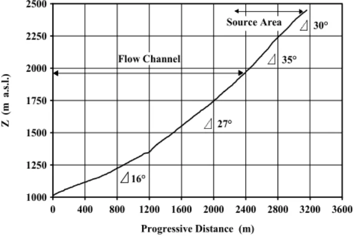
The Cancia debris-flow is characterised by a distinctive source area, flow channel and deposition area (Fig. 2). The basin that drains this area covers a surface of about 1.8 km2 and the altitude of the basin outlet is at 1150 m a.s.l. The source area is characterised by a detrital deposit area equal to 0.17 km2and a rock basin surface equal to 0.21 km2. The
flow channel has a length of about 2400 m with a mean steep-ness of 20◦. The debris fan area is about 0.6 km2. The gra-dient of the head of the basin near Forcella Salvella is about 30◦(Fig. 3); near the valley in the area of possible trigger-ing of landslides, the steepness increases until 35◦, then in the confluence of the channel with the downstreaming from the Bus del Diau it decreases to 25◦, and it continues to de-crease progressively to about 15◦ in the bottom area. The flow channel appears remarkably incised, ranging from 3– 5 m, coupled with much detrital material and banks that have risen. Its pattern follows a north-south direction in the upper part below Forcella Salvella, then it diverts westwards in the direction of the urban area, starting from the confluence with the torrent descending from Bus del Diau.
0 400 800 1200 1600 2000 2400 2800 3200 3600
Progressive Distance (m) 1000
1250 1500 1750 2000 2250 2500
Z
(m
a.
s.l
.)
16°
27°
30°
Flow Channel
Source Area
35°
Fig. 3. Longitudinal profile of the flow channel, the upper part of the source area and mean slope angles in the different sectors of the channel.
(bottom of the valley, altitude 975 m a.s.l.), Cancia Bassa (also called Borca di Cadore; confluence Salvella – Bus del Diau, altitude 1335 m a.s.l.) and Cancia Alta (below Forcella Salvella, altitude about 2260 m a.s.l.) (Fig. 2). These sites are located in the deposition area (Villanova), the transport area (Cancia Bassa) and the source area (Cancia Alta). 2.1 Geological and geomorphological settings
Pre-Quaternary terrains in the study area range from Trias-sic to JurasTrias-sic and they represent the typical dolomitic strati-graphic sequence (Viel, 1979; Bosellini, 1989; De Zanche et al., 1993; Loriga Broglio and Neri, 1995) from Fernazza Formation (Ladinian) to Calcari Grigi Formation (Lias). In the Cancia area dolomitic and calcareous walls are remark-ably high with morphological benches connected with less competent nearly-argillaceous formations. This sequence has been changed according to a rigid behaviour by faulting, which has modified the geometric relationship among the dif-ferent formations, especially during the Tertiary when two different regional tectonic phases occurred (Dinaric phase and Neogenic phase – Doglioni, 1987; Bosellini, 1989; Castellarin et al., 1992). All the structures deriving from these tectonic movements, at lower altitude and in the bot-tom of the valley, are hidden due to the abundant quaternary detrital deposits (talus, debris fan, morainic deposits and con-glomerates).
The most unique and characteristic quaternary deposits are some clastic conglomerates, clearly discordant with the underlying limestone and dolomites formations, usually in-volved in the flow by erosional processes. The conglomer-ates are deeply incised along the flow channel. In the source area the erosion is promoted by the steepness of the slope. Towards the valley, reducing the gradient, it is easier to find this quaternary formation. The conglomerates outcrop at Costa dei Landre, which acts as barrier for the flow, favour-ing the flow channel turnfavour-ing in the W–SW direction.
In the area of Borca di Cadore, in the northwestern part of
Fig. 4.Damages from the debris-flow that occurred on 27 July 1868 (a volume of material equal to 100 000 m3was deposited from this event).
the slope, a debris avalanche phenomenon of a remarkable extent is observed, which, however, represents a high insta-bility of this area, even if it is historically, but not genetically, different from the debris-flow phenomenon.
The hardly fractured dolomitic rock mass favours the for-mation of talus deposits, which have caused the development of many landslide phenomena (Panizza et al., 1998). The flowing materials have been classified as gravels with low content in sand and fine particles, with an abundance of peb-bles and blocks (grain size laboratory analysis and grain size distribution by transept-line).
2.2 Climatic setting
Storms are typical meteorological events during the summer in the alpine area. The area of Borca di Cadore has a climate of alpine type, moderated cold, class D of K¨oppen classi-fication, with vertical diversification in microclimates. The temperatures have an annual mean of 5◦C, and summer
max-imums are between 10◦ and 15◦C. Spring and autumn are moderately cold, and winter mean values, at low altitudes, are just below 0◦C. The annual thermal excursion is com-prised between 15◦and 20◦C (Panizza et al., 1998; Panizza and Zardini, 1986). Diagrams of the yearly rainfall activ-ity show a medium distribution of precipitation of 1000 mm, with maximums in spring and summer (the highest values have been recorded during the months of June and August and medium values in autumn). The snow is distributed in winter and spring and at higher altitude it is preserved until late spring, while on the valley bottom March is the month of melting. The summery storms tend to locate precipitation next to the M. Antelao and M. Sorapis, which act as barri-ers that intensify and localise the stormy cells, thanks to the forcing effect (forced raising of the air mass saturate). 2.3 Historical sequence and urban development
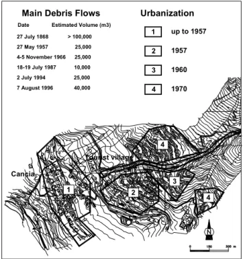
Cancia
Tourist village
Urbanization Main Debris Flows
Date Estimated Volume (m3) 27 July 1868 > 100,000 27 May 1957 25,000 4-5 November 1966 25,000 18-19 July 1987 10,000 2 July 1994 25,000 7 August 1996 40,000
up to 1957 1957
1960
1970
1 2
3 4
4 1
2
3
4
Fig. 5.Urbanization in debris-flow deposition area of Cancia.
of material was deposited (deposition area 203 000 m2). This is supposed to be the largest event. The most recent events occurred in 1994, when 25 000–30 000 m3 of mate-rial was deposited (deposition area 43 000 m2), and in 1996 which produced 40 000–45 000 m3 of material (deposition area 64 000 m2). However, other smaller events have taken place between 1868 and 1994 and in some cases these events caused damage only to infrastructures and accumulated de-trital material along the flow channel. Events in 1957, 1966, 1973, 1987 (two events), 1992, 1993, 1994, 1995, 1996, 1997 and 1998 (three events) have been documented.
Despite the increasing recurrence of the phenomenon, the village of Cancia continued to develop in the hazardous area. In particular, a tourist village was built between the 50’s and 60’s in the deposition area, including the area affected by the event of the XIX century. The 50’s and 60’s represented the apex in terms of urban development (Fig. 5). According to a multitemporal study of the aerial photographs, the historical nucleus of Cancia grew until 1957. At the beginning of 1957 the urban structure changed little, while the expansion in the fan area began with the gradual construction of the tourist village “Corte”, which ended during the 60’s. Cancia has an almost linear development, due to the road network; only the second phase of the development has made it to the moun-tain. During the 80’s and 90’s, some of the houses damaged mainly by the events in 1987, 1994 and 1996 were recon-structed. They are set along the road that connects the main valley road to the tourist village.
The increasing risk situation as a consequence of the rising hazard level of the phenomenon and the wrong urbanisation is well documented by the analysis of the deposition zones of
CANCIA
50 100 m 0
N Accumulation zone
1868
1994 1996
Fig. 6. Accumulation zones of the debris-flows that occurred in 1868, 1994 and 1996.
Fig. 7.The source area and the highest part of the flow channel.
debris-flows on the fan. The boundaries of these zones for the debris-flows that occurred on 27 July 1868, 2 July 1994 and 7 August 1996 have been determined by aerial photographs (Fig. 6). It can be observed that in all three cases, the his-torical nucleus of Cancia is involved; however, the possible occurrence of a similar event, like the one in 1868, would seriously impact even part of the tourist village. As a conse-quence of this risk, it was necessary to set up a monitoring and alarm system to safeguard the population, infrastructures and buildings (Fig. 2). The alarm system consists of the three rain gauges stations previously mentioned, of an ultrasonic echometer installed in the mid-part of the flow channel, to measure the changing depth of the channel and two traffic lights to stop vehicles on the road when debris-flow occurs.
3 The debris-flow and its triggering mechanism
0 5 10 15 20 25 30
C
u
m
u
la
ti
ve
R
a
in
fa
ll
(
m
m
)
0 5 10 15 20 25 30
C
u
mul
a
ti
ve
Ra
in
fa
ll
(
mm)
15 July 1998
25 July 1998 Cancia Bassa Villanova
Cancia Alta
0:00 1:00 2:00 3:00
Time (hour)
13:00 14:00 15:00 16:00
Time (hour)
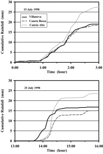
Fig. 8. Cumulative rainfall diagram of the debris-flows that oc-curred on 15 and 25 July 1998 recorded at the rain gauge stations of Villanova, Cancia Bassa and Cancia Alta. The debris-flow trigger-ing time is unknown.
pebbles (conglomerates), which are affected by erosion pro-cesses as well. Towards the valley, at the beginning of the flow channel, there is a detrital deposit whose steepness can be compared with the angle of repose of the loose material (Di Silvio, 1999). These materials are easily mobilised dur-ing periods of heavy precipitation. Since the gradient of the whole area is high, two situations are presumed to occur:
– during periods of high intensity and short duration pre-cipitation (less than one hour), pore pressure can react quickly to heavy rainfall (Sidle and Swanson, 1982), and superficial landslides of detrital materials could in-crease the amount of material in the deposit, thus caus-ing remobilisation in subsequent events;
– connected with heavy rainfall, cumulative precipitation in the source area could cause the debris-flow trigger-ing, thus remobilising at the same time the accumulated material in the deposit and the one in the upper part of the basin.
The debris-flow has a great erosive power which can be observed in the remarkable downcutting of the flow channel
0 10 20 30 40 50 60 70 80
C
u
m
u
la
ti
ve
R
a
in
fal
l
(m
m
)
5 September 1998
1:00 3:00 5:00 7:00 9:00 11:00 13:00 15:00 17:00
Time (hour) Villanova
Cancia Bassa Cancia Alta
Fig. 9.Cumulative rainfall diagram of the debris-flow that occurred on 5 September 1998 recorded at the rain gauge stations of Vil-lanova, Cancia Bassa and Cancia Alta. The debris-flow triggering time is unknown.
and in the morphologic feature of the bank erosion with the resulting addition of material during mass flow events. The flow channel is usually dry without surface runoff, also dur-ing periods of high precipitation. The high permeability of the detrital cover favours hydrogeological paths that allow subsurface runoff, and there is no track from the end of the flow channel to the Boite torrent. Valuable surface runoff occurs only during debris-flow events and higher intensity flows, thus increasing the hazardous nature of the debris-flow.
4 Results
0 5 10 15 20 25 30
Cumul
a
ti
v
e Rai
n
fa
ll
(mm)
02/07/94 23:00-01:00
07/08/96 19:00-21:00 trigger
0 20 40 60 80 100 120 Time (min.)
storm beginning
Fig. 10. Cumulative rainfall diagram of the debris-flows that oc-curred on 2 July 1994 and 7 August 1996 recorded at the rain gauge station of Villanova.
debris-flow triggering (Fig. 8). However, the behaviour of the stormy cells in the area has an important role in defining cumulative rainfall and intensity that causes debris-flow ini-tiation. The comparison among the three rain gauge records could be decisive in identifying a representative station, even if its existence cannot be known for certain. Unfortunately, there is not enough data referring to the Cancia Alta and Can-cia Bassa stations due to their short period of use linked to debris-flow events. This fact has reduced the possibility of identifying a representative station, even if the Cancia Alta rain gauge could be the most representative due to its close-ness to the triggering area. Data recording in the next few years will be important to determine if data from a repre-sentative station could be used for threshold computation. However, the role of stormy cells seems more decisive for debris-flow triggering for the study case, and case-by-case situations should be considered for the rain gauge network, in order to better understand the triggering mechanism with respect to the cumulative rainfall and intensity of rainstorms. Concerning the five events that could enable a correct anal-ysis of the phenomenon (2 July 1994, 7 August 1996, 15 July 1998, 25 July 1998 and 5 September 1998), reliable in-formation about the triggering time is only available during 1994 and 1996, because the events were very destructive and reached the village of Cancia (Fig. 10). The debris-flows that occurred in 1998 stopped before the ultrasonic echome-ter and no information about the triggering time is available, but day-after surveys of technicians managing the monitoring system ensured that the debris-flow was triggered. As for the two events in July 1998, it is possible to determine the time when the debris-flow occurred, thanks to the short rainfall duration linked with possible moments when the debris-flow was triggered. Unfortunately, this process cannot be used for the event occurring in September due to rainfall duration, because the obtained interval is too long. On the basis of the analyses carried out, a comparison with other cases of debris-flow occurred in the north-eastern alpine area in different or
0.1 1.0 10.0 100.0
Duration (h)
1 10 100 1000
Mean
I
nten
sit
y
(m
m/
h
)
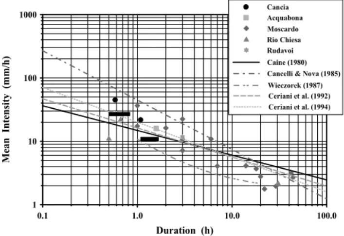
Cancia Acquabona Moscardo Rio Chiesa Rudavoi Caine (1980) Cancelli & Nova (1985) Wieczorek (1987) Ceriani et al. (1992) Ceriani et al. (1994)
Fig. 11.Rainfall intensity vs. duration and debris-flow correlation. Cancia debris-flows are represented with a point when the triggering time is known (1994 and 1996 events) and with a rectangle that considers the intervals of possible intensity and duration when the triggering time is uncertain (July 1998 events).
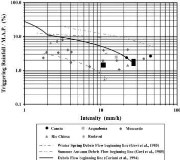
similar geologic settings has been made. The analysed data has been used to plot an intensity-duration graph (Fig. 11) in which it is possible to check the data behaviour in compar-ison with critical lines suggested by different authors in the literature (Caine, 1980; Cancelli and Nova, 1985; Wieczorek, 1987; Ceriani et al., 1992, 1994). According to this analy-sis, a homogeneous behaviour in the Cancia case has been recorded that can be compared to the cases of the Dolomites. The available data underlines that the triggering rainfall does not have very high values (usually between 20 and 30 mm in 1–2 h), but does have a short duration and intermediate-high intensity. The data referring to the 1994, 1996 and July 1998 events has been used both in the graph of normalised intensity on Mean Annual Precipitation (M.A.P.) – duration (Fig. 12, Cannon, 1988), and in the graph of normalised trig-gering rainfall on M.A.P. – intensity (Fig. 13, Govi et al., 1985).
0.1 1.0 10.0 100.0 Duration (h)
0.1 1.0 10.0
In
te
n
sit
y / M.A
.P
.
(
%
)
Cancia Acquabona Moscardo
Rio Chiesa Rudavoi
Debris Flow beginning line (Ceriani et al., 1994)
Fig. 12. Normalized rainfall intensity (intensity/M.A.P.) vs. dura-tion and debris-flow correladura-tion. Cancia debris-flow representadura-tion is the same as in Fig. 11. The dashed line shows the debris-flow threshold proposed for the study area.
at the beginning of the initiation area) and the Rio Chiesa (drainage area 0.65 km2). The M.A.P. is quite similar for all sites (about 1000 mm), except for the Moscardo Torrent where it reaches 1600 mm.
According to the analysis of the whole range of studied cases, most of the events occur in the stability area, below the thresholds suggested by Govi et al. (1985) and Ceriani et al. (1994). In each graph, however, a new possible debris-flow starting line is delineated and connected with the con-sidered cases; it is lower than the one suggested by Ceriani et al. (1994) and with an almost parallel trend. This different lower threshold can be explained by the following reasons:
– the case study we have shown concern only small basins which are particularly prone to landslides;
– the climate, very similar among our cases, is different in comparison with the one considered by Ceriani et al. (1994);
– the high predisposition and recurrence of debris-flow phenomena in the studied alpine area is due to the re-gional character of our research; instead, Ceriani et al. (1994) considered debris-flows which occurred in a wider alpine area (Central Alps in Lombardia region and Western Alps in Piemonte region), in very different environments from a geological, geomorphological and meteorological point of view;
– the triggering features of the analysed cases are differ-ent from those Ceriani et al. (1994) studied: debris-flow, debris torrent, debris avalanches, soil slip and other hy-drological damages like floods and consequent sliding phenomena of different sizes (Ceriani et al., 1994). The obtained data can be considered reliable enough to determine equations of the debris-flow threshold that we are proposing. The normalised rainfall and the normalised inten-sity expressed as per cent with respect to M.A.P. are:
Rn= −1.36·ln(I )+3.93, whereI >2 mm/h (1)
1 10 100
Intensity (mm/h)
0.1 1.0 10.0 100.0
Trigge
ring
R
a
infall /
M.A
.P.
(%
)
Cancia Acquabona Moscardo
Rio Chiesa Rudavoi
Winter Spring Debris Flow beginning line (Govi et al., 1985)
Summer Autumn Debris Flow beginning line (Govi et al., 1985)
Debris Flow beginning line (Ceriani et al., 1994)
Fig. 13. Normalized rainfall (rainfall/M.A.P.) vs. intensity and debris-flow correlation. Cancia debris-flow representation is the same as in Fig. 11. The dashed line shows the debris-flow threshold proposed for the study area.
In=0.74·D−0.56 (2)
with
D Duration(h)
I Mean intensity(mm/h)
Rn=
R
M.A.P . Normalised rainfall(%) In=
I
M.A.P . Normalised intensity(%).
However, we would like to underline that new data con-cerning other further events is necessary to check and to im-prove this threshold in the future, and after all, it cannot have a forecast-value due to the precipitation duration and the time passing between two subsequent meteorological events. The identification of such thresholds needs real-time data acqui-sition (Bottino et al., 1996), especially for the management of a monitoring system. It is thought that in the analysed case the identification of a minimum threshold is useful as a warning level for those managing the monitoring system, but it cannot be used to alert the population at this time.
5 Conclusions
threshold conditions defined by others shows that this one is a lower triggering threshold. This is due to the regional char-acter of the study, the unique meteorological, geologic and geomorphological conditions of the case studies and the fea-tures of the triggering mechanism. However, it is underlined that the studied area is particularly affected by debris-flows, and considering the urban development, there are high-risk conditions.
As for the Cancia debris-flow, the data collected by the three rain gauge stations has enabled a preliminary analysis of the precipitation trend connected with the altitude, even if the lack of data recorded in the two stations at higher al-titude (due to their recent installation) has not allowed for a more detailed research. However, this network of stations has turned out to be greatly positive for the debris-flow stud-ies, in order to improve the debris-flow threshold knowledge, to analyse the trend of stormy cells, which is important for critical rainfall forecast, triggering debris-flow, and finally to develop new technologies for the improvement of the alarm system. As our study suggests, the determination of a mini-mum threshold could be useful for the requirements of civil protection, which are linked to the management of the mon-itoring system. However, the authorities in charge for these tasks should use more sophisticated models, based on critical precipitation forecast, in order to plan the population warn-ing.
Indirect geophysics surveying (electrical tomography) is going on in the area of Cancia with the aim of estimating the volumes of mobilised, deposited and still movable material and of delineating in detail the geomorphologic evolution of the area. Moreover, it would be necessary to calibrate the interpretative model derived from geoelectric surveying with useful drillings equipped with piezometric cells to measure the groundwater level and the pore pressure. The increase in knowledge would be useful to carry out more detailed analy-ses of pluviometric data and of the role that rainfall duration and intensity play in the debris-flow triggering mechanism of Cancia.
Acknowledgements. The authors are indebted to the Regional Au-thority of Veneto for the hydrological data.
References
Bosellini, A.: La storia geologica delle Dolomiti, Ed. Dolomiti Cortina, pp. 148, 1989.
Bottino, G., Crivellari, R., and Mandrone, G.: Eventi pluviometrici critici e dissesti: individuazione delle soglie d’innesco di colate detritiche nell’ anfiteatro morenico di Ivrea, Proc. La preven-zione delle catastrofi idrogeologiche: il contributo della ricerca scientifica, Vol. II, 201–210, Alba (CN), 1996.
Caine, N.: The rainfall intensity-duration control of shallow land-slides and debris-flows, Geografiska Annaler, 62A (1–2), 23–27, 1980.
Cancelli, A. and Nova, R.: Landslide in soil debris cover triggered by rainstorm in Valtellina (Central Alps, Italy), Proc. IVth Inter. Conf. and Field Workshop on Landslides, Tokyo, 1985.
Cannon, S. H.: Regional rainfall-threshold conditions for abundant debris-flow activity, In: Landslides, Floods and Marine effects of the storm of 3–5 January 1982 in the San Francisco Bay Re-gion, California, (Eds) Ellen, S. D. and Wieczorek, G. F., USGS Professional Paper 1434, 35–42, 1988.
Cascini, L. and Versace, P.: Eventi pluviometrici e movimenti franosi, Proc. A.G.I. XVI Convegno Nazionale di geotecnica, Bologna, Italy, Vol. III, 171–184, 1986.
Castellarin, A., Cantelli, L., Fesce, A. M., Mercier, J. L., Picciotti, V., Pini, G. A., and Selli, L.: Alpine compressional tectonic in the Southern Alps. Relationships with the Appennines, Annales Tecttonicae, 6 (1), 62–94, 1992.
Ceriani, M., Lauzi, S., and Padovan, N.: Rainfalls and landslides in the alpine area of Lombardia region – Central Alps – Italy, Proc. Interpraevent 1992, Bern, Switzerland, Band 2, 9–20, 1992. Ceriani, M., Lauzi, S., and Padovan, N.: Rainfall thresholds
trig-gering debris-flows in the alpine area of Lombardia Region, cen-tral Alps – Italy, Proc. Man and Mountain, I Conv. Intern. per la Protezione e lo Sviluppo dell’ambiente montano, Ponte di legno (BS), 123–139, 1994.
Deganutti, M. A., Marchi, L., and Arattano, M.: Rainfall and debris-flow occurrence in the Moscardo basin (Italian Alps), In Debris-flow hazard mitigation – Mechanics, Prediction, and As-sessment, (Eds) Wieczorek, G. F. and Naeser, N. D., Balkema, Rotterdam, 67–72, 2000.
De Zanche, V., Gianolla, P., Mietto, P., Siorpaes, C., and Vail, P. R.: Triassic sequence stratigraphy in the dolomites (Italy), Mem. Sc. Geol. Univ. Padova, 45, 1993.
Di Silvio, G.: Studio sulle modalit`a d’innesco e sull’entit`a delle colate detritiche in localit`a Cancia, Borca di Cadore (Belluno), Regione Veneto-Universit`a degli Studi di Padova, Dipartimento Ingegneria idraulica, marittima e geotecnica, pp. 19, 1999. Doglioni, C. Tectonics of the Dolomites (Southern Alps – Nothern
Italy), J. Struct. Geol., 9, 181–193, 1987.
Govi, M., Mortara, G., and Sorzana, P. F.: Eventi idrologici e frane, Geol. Appl. e Idrog., 20(2), 359–375, 1985.
Govi, M. and Sorzana, P. F.: Landslide susceptibility as a func-tion of critical rainfall amount in Piedmont basin (Northwest-ern Italy), Studia Geomorph. Carpatho-Balcanica, 14, 43–61, Krakow, 1980.
Genevois, R., Tecca, P. R., Berti, M., and Simoni, A.: Debris-flows in Dolomites: Experimental data from a monitoring system, In Debris-flow hazard mitigation – Mechanics, Prediction, and As-sessment, (Eds) Wieczorek, G. F. and Naeser,N. D., Balkema, Rotterdam, 283–291, 2000.
Innes, J. L.: Debris-flows, Progress in Physical Geography, 7 (4), 469–501, 1983.
Larsen, M. C. and Simon, A.: A rainfall-intensity-duration thresh-old for landslide in a humid-tropical environment, Puerto Rico, Geogr. Ann., 75A (1–2), 13–23, 1993.
Loriga Broglio, C. and Neri, C.: Verso una definizione del limite Ladinico-Carnico nel Sudalpino orientale, Ann. Uni. Ferrara, 5, Suppl. Sc. Terra, 1995.
Marchi, L. and Pasuto, A.: A debris-flow in the Dolomites, North-eastern Italy, Landslide News, 12, 9–12, 1999.
Panizza, M.: Glacio-pressure implications in the production of landslides in the dolomitic area, Geol. Appl. e Idrog., 8 (1), 289– 297, 1973.
Panizza, M. and Zardini, R.: La grande frana su cui `e sorta Cortina d’Ampezzo, Ed Dolomiti Cortina, pp. 101, 1986.
Au-gust 1996, Mem. Soc. Geol. It., 53, 465–478, 1998.
Sidle, R. C. and Swanson, D. N.: Analysis of a small debris slide in coastal Alaska, Canadian Geotechnical Journal, 19 (2), 167–174, 1982.
Viel, G.: Litostratigrafia ladinica: una revisione. Una ricostruzione paleogeografica e paleostrutturale dell’area Dolomitico-Cadorina (Alpi Meridionali), Riv. It. Paleont. Strat., 85 (1), 85–125, 85 (2), 297–352, 1979.
Wieczorek, G. F.: Effect of rainfall intensity and duration on debris-flows in central Santa Cruz Mountains, California, In Debris-flows/ Avalanches: process, recognition and mitigation, (Eds) Costa, J. E. and Wieczorek, G. F., Geological Society of Amer-ica, Reviews in Engineering Geology, Vol. VII, 93–104, 1987.
Wilson, R. C.: Climatic variations in rainfall thresholds for debris-flow activity, In Mediterranean Storms Proceedings of the EGS Plinius Conference held at Maratea, Italy, 14–16 October 1999, (Eds) Claps, P. and Siccardi, F., Ed. Bios, Cosenza, 415–424, 2000.
Wilson, R. C., Mark, R. K., and Barbato, G.: Operation of a real-time warning system for debris flows in the San Francisco Bay area, California, In Proceedings of Hydraulic Engineering 1993, (Eds) Shen, H. W., Su, S. T., and Wen, F., Vol. II, 1908–1913, New York, ASCE, 1993.