o
http://dx.doi.org/10.1590/S1982-21702015000100008
LAND CAPABILITY EVALUATION FOR ECOTOURISM
DEVELOPMENT IN ILAM PROVINCE, A GIS APPROACH
Avaliação da capacidade da terra para desenvolvimento de ecoturismo na província de Ilam, uma abordagem com utilização de SIG
MEHDI AHMADI*1 SHAMSOLLAH ASGARI2 EZATOLLAH GHANAVATI3
1
Department of Geomorphology, Faculty of Geography, Kharazmi University, Tehran, Iran
2
Scientific Member of Agriculture and Natural Resources Reserch Center of Ilam Provience, Iran
3
Department of Geomorphology, Faculty of Geography, Kharazmi University, Tehran, Iran
*
Corresponding Author: Mehdi Ahmadi; Email: [email protected]; Cell Phone: +989189405535
ABSTRACT
Keywords: Land Capability Evaluation; Ecotourism Development; Boolean
Algebra; Ilam Province (Iran); Geographic Information System; Remote Sensing.
RESUMO
Como uma das indústrias mais geradoras de riqueza no mundo, o turismo tem sido o centro das atenções de muitos governos em todo o mundo. Dependendo da finalidade do turismo, ele foi classificado em diferentes tipos, um dos quais é o ecoturismo. O ecoturismo é responsável atualmente por uma pequena parcela das receitas; no entanto, tem uma alta taxa de crescimento. O presente estudo de caso visa ao zoneamento de áreas adequadas em Ilam, uma província no oeste do Irã, para fins de desenvolvimento do ecoturismo. Assim, foram elaborados inicialmente os mapas digitais de altitude, declividade, cobertura vegetal, uso do solo, nascentes de água mineral e de recursos hídricos. Depois, as áreas adequadas e inadequadas foram separadas por funções booleanas. A sobreposição das camadas através de um GIS permitiu identificar as áreas mais adequadas. Os resultados obtidos revelaram que as principais atrações estão localizadas, principalmente, nas província do norte e central, em direção sudeste, regiões em que a condição climática é favorável, e são ricas em recursos naturais de cobertura do solo e de água. Além disso, as regiões sul e oeste foram avaliados como pobres em termos de atrações eco-turísticas.
Palavras-chave: Avaliação da Aptidão das Terras; Desenvolvimento do
Ecoturismo; Álgebra Booleana; Província de Ilam (Irã); Sistema de Informação Geográfica; Sensoriamento Remoto.
1. INTRODUCTION
Tourism development as an economic activity has a significant impact on empowering local communities. The role of tourism, as a new source of job creation, revenues, taxes, and currencies, has been taken into consideration by numerous studies (Howard, 2009).
Nowadays, the development of tourism is widely accepted and placed on the agenda by developing and developed countries (Stueve, 2002). Tourism leads money and population from industrial centers towards natural and rural areas. The revenue from tourism contributes to the economy and social welfare of the host country (Cater, 1994). According to World Tourism Organization (WTO), ecotourism proportion will reach from the current of 7% to 20% in the coming decade (Ross, 1980).
o
giving natural unspoilt areas an economic value are the most important benefits of ecotourism (Alpert, 1996).
It can also create benefits for local people and attract international support for protected areas (Fennel, 1999). Hence, the support and participation of local people is essential to achieve sustainable ecotourism (Yoon, 2001). Ecotourism development should increase the maximum local participation in conservation of natural areas (Cooke, 1982).
The correct diagnosis of tourist behavior will contribute to suitable site selection of tourist destinations (Bansal, 2004). Ecotourism is defined as responsible travel to nature where the flora, fauna, and cultural heritage are the primary attractions in a way to conserve the environment and improves the well-being of local people (Boo, 1990). Due to great income generation, tourism and ecotourism have urged countries to pay special attention to this industry (Tremblay, 2006). This form of tourism is based on purposeful travel coupled with cultural and spiritual understandings of a variety of natural phenomena (Choong, 2008). Ecotourism means traveling to different parts of countries to visit natural monuments and get more familiar with different cultures.
Given the mentioned circumstances, what is important in this type of tourism is the issue of sustainability (Honey, 2008). Valuation of ecosystem services and natural environment is very important for sustainable tourism management. There has been a wide range of approaches and methods presented in recent years to evaluate ecosystem values (Eade and Moran, 1996; Guo et al., 2001; Hein et al., 2006; Troy and Wilson, 2006; Egoh et al., 2008). According to literature, Ceballos-Lascurain (1993) is the one who first used the concept of ecotourism. He defined it as ―a form of environmentally responsible tourism that involves travel and visitation to relatively undisturbed natural areas with the object of enjoying, admiring, and studying the nature (the scenery, wild plants, and animals), as well as any cultural aspect (both past and present) found in these areas, through a process which promotes conservation, has a low impact on the environment and on culture and favors the active and socioeconomically beneficial involvement of local communities".
Banerjee et al. (2002) identified potential ecotourism sites in eastern India using Remote Sensing (RS) and GIS techniques in forest dominated areas of western Midnapore, West Bengal. They prepared the final ecotourism capability map by overlaying the map layers of land use/land cover, soil fertility, and ecological features.
In a study by Elliott-White in 1997, the application of GIS in post-modern tourism marketing was investigated. Further, the role of GIS in tourism planning and rural economic development was studied by Savitsky et al. in 1999. The researches by Lee and Mjelde in 2012, Sanjay in 2007, Lung Shaw in 2007, and Baral in 2007 are other examples of feasibility studies for ecotourism development. Turner et al. in 1995 and Laughland et al. in 1996 mainly focused on the role of ecosystem services in ecotourism blooming.
There are some relevant research projects conducted by Department of Environment of Ilam Province on ecotourism developement. As such, the historic buildings of Ilam by Heidari et al. in 2003, investigation of tourism building in Ilam by Johari in 2005, and land capability evaluation of Ilam are among notable research projects that could be mentioned (Jafree, 2003). Although Iran is ranked 10th in the world in terms of tourist attractions and 5th in the world in view of Earth's greatest biological diversity, however, it has failed to take a proper position in the world in attracting tourists. The share of tourism revenues in Iran is about a thousandth of the global income (Amami, 2000). Despite having many attractions, there have been done no scientific feasibility studies on introducing and analyzing potential sites for ecotourism developement. Accordingly, the present study was conducted to introduce ecotourism values of the Ilam Province. The obtained results could be used by tourists and planners.
2. MATERIAL AND METHODS 2.1 The study area
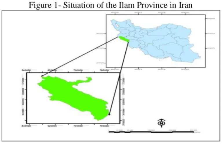
The Ilam Province, with an area of about 20, 150 m2, includes approximately 1.4% of the total area of Iran. It is situated in western and southwestern Iran between the latitudes 31º 58'-34º 15' N and the longitude 45º 24'-48º 10' E (Encyclopedia of Ilam City, 2008) (Figure 1).
o 2.2 Boolean Logic Model
In overlaying function, the Boolean logic operations are based on Boolean algebra in which the values of the variables are the truth values true and false. First used by Varennes in 1947, the Boolean model is a multi-conditional inquiry by which suitability maps could be presented as 0 and 1 subsets (Olazade, 2005). This model has a two-element set of suitability and unsuitability and there is no other state in the middle (Sanaei Nejad, 1999).
2.3 Data collection and processing
In order to evaluate ecological capability of Ilam Province, the maps of land cover, slope, land use, and hydrology were used. The topographic map of the study area at the scale of 1:50,000 was used to extract some geomorphological features including faults, ridges, and elevation points. The slope map was extracted from the Digital Elevation Model (DEM) to specify areas with the slope of higher than 20%, which are suitable for rock climbing, hiking in steep terrain, mountaineering, and hillside climbing. The Indian Remote Sensing (IRS) LISS-III (Linear Imaging Self Scanning Sensor) sensor (with the spatial resolution of 23x23m) and ETM+ satellite images were prepared from the Geographical Organization of Iran in order extract land use and land cover map of the study area using ERDAS IMAGINE Software. It is worth mentioning that LISS-III sensor is an optical sensor working in four spectral bands of green, red, near infrared, and short wave infrared. It covers a 141 km-wide swath with a resolution of 23 metres in all spectral bands. The current land use map was obtained from the landsat satellite images dating to 2002. The isothermal map of the province was used to zone suitable temperature areas and to identify places with low temperature for winter activities such as skiing. Moreover, the slope and hillshade maps were used to identify the accumulation places of snow and ice as an important prerequisite for establishment of ski resort. It is worth noting that the mentioned maps were all prepared from the DEM. The drainage network map of the province at the scale of 1:250,000 was prepared from the Department of Environment (DOE). The map of fragile habitats and protected areas was obtained from Administration of Environmental Protection in Ilam Province. The data was used for zoning authorized hunting and fishing areas. The map of historic attractions was prepared based on the comprehensive plan for feasibility study of typical tourism resorts conducted by Cultural Heritage Department of Ilam Province. These areas were represented as a point map taken by GPS from the study area.
2.4 Data processnig
words, each cell size of the final map is suitable or unsuitable for ecotourism development and there is no intermediate state. The logic is involved in two numbers; 0 and 1, of which 1 represents suitability of a pixel size, while 0 shows unacceptable situation or unsuitability of a pixel size (Hall et al,1992). Tables 1 and 2 give the functions applied for overlaying each of the map layers. After weighting the map layers, the final ecotourism development map was prepared using Boolean logic. The spatial distribution of suitable tourism resorts are specified are presented on the final map.
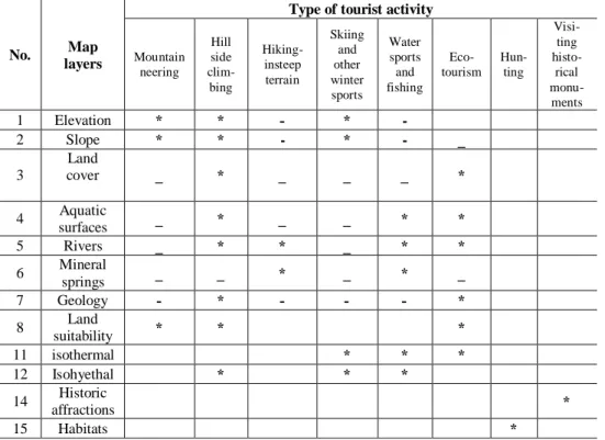
Table 1- Map layers used for Boolean-based ecotourism land capability evaluation (Faraj Zadeh, 2008)
No. Map
layers
Type of tourist activity
Mountain neering Hill side clim-bing Hiking-insteep terrain Skiing and other winter sports Water sports and fishing Eco-tourism Hun-ting Visi-ting histo-rical monu-ments
1 Elevation * * - * -
2 Slope * * - * - _
3
Land
cover _ * _ _ _ *
4 Aquatic
surfaces _ * _ _ * *
5 Rivers _ * * _ * *
6 Mineral
springs _ _ * _ * _
7 Geology - * - - - *
8 Land
suitability * * *
11 isothermal * * *
12 Isohyethal * * *
14 Historic
affractions *
o
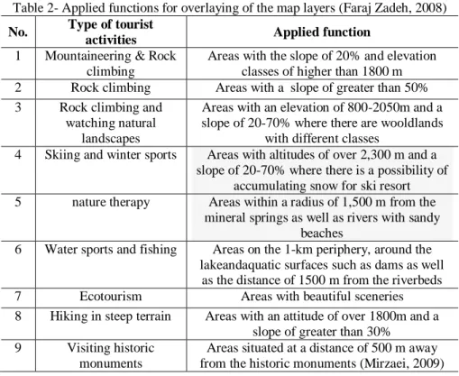
Table 2- Applied functions for overlaying of the map layers (Faraj Zadeh, 2008)
No. Type of tourist
activities Applied function
1 Mountaineering & Rock climbing
Areas with the slope of 20% and elevation classes of higher than 1800 m 2 Rock climbing Areas with a slope of greater than 50% 3 Rock climbing and
watching natural landscapes
Areas with an elevation of 800-2050m and a slope of 20-70% where there are wooldlands
with different classes
4 Skiing and winter sports Areas with altitudes of over 2,300 m and a slope of 20-70% where there is a possibility of
accumulating snow for ski resort 5 nature therapy Areas within a radius of 1,500 m from the
mineral springs as well as rivers with sandy beaches
6 Water sports and fishing Areas on the 1-km periphery, around the lakeandaquatic surfaces such as dams as well
as the distance of 1500 m from the riverbeds 7 Ecotourism Areas with beautiful sceneries
8 Hiking in steep terrain Areas with an attitude of over 1800m and a slope of greater than 30%
9 Visiting historic monuments
Areas situated at a distance of 500 m away from the historic monuments (Mirzaei, 2009)
3. RESULT AND DISCUSSION
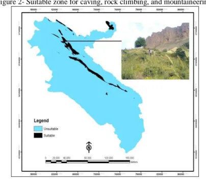
3.1 Suitable zones for mountaineering, caving, and rock climbing
potential to rock climbing sport. This zone contains a large number of the county’s well-known caves, one of which is Agha Cave has not been explored yet.
Figure 2- Suitable zone for caving, rock climbing, and mountaineering.
3.2 Suitable zones for hillside climbing and visiting natural landscapes
o
Figure 3- Suitable zones for hillside climbing and visiting natural landscapes
3.3 Suitable zones for ecotourism and individual or family camping
Figure 4- Suitable zones for ecotourism and individual or family camping
3.4 Suitable zones for water sports, swimming, and fishing
This zone is scattered in many different places, including around 12.4% (280703 ha )of the entire area of the province. The River Samireh, the longest river in the province, Kangir River, Siah Gav Wetland, the water basin of the Dams Ilam, and Ranguvan are among important water sport resorts. These areas include mainly the 1500 m-periphery of the major rivers and springs. Figure 5 shows suitable zones for water sports, swimming, and fishing. The top right photo shows the artificial lake of the Ilam Dam while the bottom photo is one of the most amazing natural aquariums of Iran situated at the distance of 140 km far from the Ilam City resulted from the karst water discharge of Kabir Kouh Mountain. The aquarium has a depth of 30 m and the total area of both wetlands is less than 1 ha. This zone has been selected as one of the international target resorts.
o 3.5 Suitable zones for hunting
In these areas, fishing and hunting must be done with the permission and under certain conditions. This zone does not include the protected areas of Manasht and Gholarang in the western province. As mentioned earlier, it is not allowed to hunt in other areas of the province unless observation of the necessary conditions. This is to prevent poaching. This zone includes large parts of the province. Figure 6 illustrats suitable zones for controled hunting: The picture on the right is one of the Ilam’s animal habitats. The hunting and fishing is done in this zone under specific conditions in the anticipated seasons. The limitation is severe in hunting of mammals due to a sharp decline in their numbers in recent years.
Figure 6- Suitable zones for controled hunting
3.6 Suitable zones for visiting historical monuments
Figure 7- Suitable zones for visiting historical monuments
3.7 Suitable zone for nature therapy
This zone includes areas in adjacent to the mineral springs. Covering approximately 0.1%(710 ha) of total area of the province, these areas are situated in Dehloran County (Dehloran Hot Spring, 3 Km away from the Dehloran County), Ilam County (Tang Bichar Hot Spring), and Dashtlag Hot Spring. Sulphurous hot springs with healing properties are located at a distance of 3 km from the Dehloran County, at the hillside of Siahkouh Mountain and in the vicinity of the Khofash (semantically equivalent to bat) Cave. With an approximate temperature of 50 ºC, it contains hot springs and sludge therapy pools that are of particular health care importance. This is a very effective healing source for rheumatism, allergies, wounds, broken bones, and bruises (Figure 8).
o 3.8 Suitable zones for winter sports
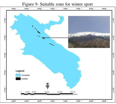
The Ilam Province has high and dense mountains. The mountains with an altitude of over 3000 m are rarely observed in the province so that the mountains higher than 2000 m include less than 2% (8087 ha) of the total area of the province. There are few mountains in the province with the altitude of higher than 2600 m. Heavy snow showers in winter (more than 400 mm) have created a thick layer of snow on the mountains. The suitable areas for winter sports constitute around 1.51% (8087 ha)of the total area of the province. Figure 9 gives suitable zone for winter sport. The photo on the right is one of the Kabir Mountain’s peaks where is suitable for winter sports. The height of the top of the peak is 9 thousand feet where the rainfall exceeds 1000 mm per year. Heavy precipitations in winter provide that certain conditions for winter sports.
Figure 9- Suitable zone for winter sport
3.9 Final ecotourism zoning map
Figure 10- Final map of suitable zones for ecotourism planning in the Ilam Province based on the Boolean logic
The zone No. 0: this zone has no potential for ecotourism developement. It includes 47% (1029652 ha)of the total area of the province. Homogeneous terrain in the southern and border areas creates a uniform landscape in the Zone 0. Accordingly, gentle slopes and the altitude of less than 800m, the zone has no potential to establish any of the tourism activities listed exept for the areas in the periphery of the rivers and the Dehloran Hot Spring,.
Zone No. 1: this zone has the required potential for just one ecotourism activity. Including more than 26%(520612 ha) of the entire area, this zone has the largest extent in the province. It covers southern and border areas, the 1500m - periphery of the Rivers Doyraj, Meymeh, Gavi, and Changouleh. This zone can be seen in the southern province as a yellow spot including the Dehloran Hot Spring. The hillside climbing and water sports are among the tourism resorts of the zone. Zone No. 2: this zone is mainly scattered in the central and Northern Province where the required potentials for the hillside claiming and ecotourism are provided and forest land cover reaches its greatest extent. The altitude of this zone ranges between 800 m to 2000 m and the rainfall varies from 400 mm to 800 mm. Constituting 17% (341325 ha)of the total area, this zone is seen as spots in other parts of the province.
o
(58842 ha)of the zone. As the most suitable area for rock climbing sport, this zone is one of the pristine areas of the province including lush green slopes of the high mountains. It is among the rainiest regions of the province covered by oak forest with dense and semi-dense canopy and bulk volume rocks. Around 3.6% (65392 ha)of the total area of the zone is allocated to the zone 3.
Zone No. 4: this zone is usually observed as red spots throughout the central province where the highest elevation is 3062 m (Varzing) and the maximum precipitation is 863 mm (in Chenarbashi Village). Having a wilderness landscape, this zone has the required potential for the ecotourism activities including mountaineering, hillside climbing, visiting natural landscapes, ecotourism, and winter sports. This zone has the highest potential for ecotourism development compared to other areas. Although the Ilam Province, with an area of 20000 km2, is considered as one of the smallest provinces of Iran, however, it has an incredible diversity of climatic and pedologic situations. It is a few kilometers away from the snow-capped mountains and includes warm plains, and the old oak and palm trees. In general, the different highlands compose the landscape of the Ilam Province. The mountain landscape with forested valleys is created one of the most beautiful natural landscapes in the region (Figure 10).
4. CONCLUSION
The results obtained from data analysis revealed that around 53%(1029652 ha) of the total area of the Ilam Province has the required potential for ecotourism activities such as mountaineering, caving, hillside climbing, nature therapy, winter sports, etc. In this study, the map layers including elevation, slope, land cover, hydrology and so on were overlaid using Boolean logic to determine land capability of the province for different ecotourism activities. According to the results, the ecotourism with the total area of more than 30% (592808 ha) allocates itself the maximum extent. This is due to rich land cover and forest areas of the province so that woodland and rangeland areas cover 30% (619179 ha) and 80% (1634634 ha) of the total area of the province, respectively. The second top priority tourism activity is hillside climbing due to high density of mountain areas covered by wilderness land cover in an area of 10.7%(186463 ha) with gentle slopes. The nature therapy with an area of less than 0. 1% (710 ha ) has the smallest extent in the study area. It is worth nothing that these zones were identified based on the rigorous approach of Boolean logic and it does not mean that other areas have a poor recreational potential. The other parts could also be evaluated from other points of view. What has been investigated in this research is to zone and introduce suitable sites in the form of an ecotourism map which can be used as a workplan for ecotourism development in the study area.
ACKNOWLEDGEMENT
REFERENCES
AHMADI, M., identify areas suitable for geotourism development in Ilam province using GIS. Master's thesis. kharazmi University, 2009.
AHMADI, M. identify areas suitable for ecotourism development in the darecahrr township using AHP model . International Conference on Tourism and
Sustainable Development, Tehran,2011.
AMAMI MEYBODI, A. Principles of Performance Measurement and Productivity Institute. Business Research,2000.
BARAL, B.; STERNB, M. J.; BHATTARAI ,R. Contingent valuation of ecotourism in Annapurna conservation area, Nepal: Implications for sustainable park finance and local development.
ALPET, P. Integrated conservation and development projects. Bioscience, 46, P. 845–855, 1996.
BANSAL, P. D.; ARNOLD. J.; ELBERG, M. A.; KALDA, J.; SOESOO, A.; VAN MILLIGEN, B. P., "Melt extraction and accumulation from partially moltern rocks", Lithos ,78, 25,2004.
BANERJEE,U.K.S.; KUMARI, S.K.P.; SUDHAKAR, Remote Sensing and GIS based ecotourism planning :A case study for westrern Mindnapore, West Bengal India,2002.
BOO, E. "Ecotourism: The potentials and pitfalls", Washington, DC, World Wildlife Fund: 21-33, 1990.
BOYD, S.W.; BUTLER, R.W.L; HAIDER, W.; PERERA, A. Identifying areas for ecotourism in northern Ontario: application of a geographic information system methodology. Journal of Applied Recreation Research,19 ,P.41–66, 1994.
BRANDON, K. Ecotourism and conservation: A review of key issues.Washington, DC: World Bank. 1996.
BRANDON, K. Moving beyond Integrated Conservation and Development Projects (ICDPs) to achieve biodiversity conservation. In D. R. Lee, & C. B. Barrett (Eds.), Tradeoffs or synergies?Agricultural intensification, economic development and the environment. New York, NY: CABI Publishing. pp. P.417–432,2001.
BUKENYA; JAMES, O. Application of GIS in ecotourism development descisions :evidence from the pearl of Africa, natural resource economics program, west Virginia university – Morgantown,wv,2,P.6506-6108,2002. CATER, E. Ecotourism in the third world: problems andprospects for
sustainability. In E. Cater, & G. Lowman (Eds.),Ecotourism: A sustainable option? Chichester: Wiley, pp. 69–86,1994.
o
CEBALLOS-LASCURAIN, H. Introduction. In K. Lindberg, M. E. Wood, & D. Engeldrum (Eds.), Ecotourism: A guide for planners and managers, pp. 7–10, 1998.
CHANGA, K.F.; C.M.; CHIANBG, P.C. Chouc, Adapting aspects of GB Tool 200`—searching for suitability in Taiwan, Building and Environment,42, P.310–316, 2007.
LEE CH. K.; SONG H..J.; Mjelde J.W. the forecasting of international Expo tourism using guantitative and gualitative techniques.tourism
management,29,P.1054-1098, 2008.
COOKE, K. Guidelines for socially appropriate tourism developmentin British Columbia. Journal of Travel Research, 21, P.22–28,1982.
DYE, A.S.; LUNG SHAW, SH. A GIS-based spatial decision support system for tourists of Great Smoky Mountains National Park. Journal of Retailing and Consumer Services, 14, P.269–278, 2007.
DONDO, CH.; BHUNU, S.T.; Rivertt, U. GIS in tourism – A Zimbabwean perspective , the international archives of photogrammetry, remote sensing and spatial information sciences,vol .xxx IV, part 6/w6. 2003.
EGOH, B.; REYERS, B.; ROUGET, M.; RICHARDSON, D.M.; LE MAITRE, D.C.; VAN JAARSVELD, A.S. Mapping ecosystem services for planning and management. Agriculture, Ecosystems and Environment ,127, P.135– 140, 2008.
ELLIOTT-WHITE, M.P.; FINN, M. Growing in sophistication: the application of geographic information systems in post-modern tourism marketing. Journal of Travel and Tourism Marketing ,7 ,P.65–84, 1997.
Encyclopedia of Ilam city. Armed Forces Geographical Organisation Publishing. Tehran, Iran. 2008.
FARAJ ZADEH, M. Analysis zones for ecotourism development in Kurdistan province using GIS, Journal of Geographical research, 2008.
GUO, Z.W.; XIAO, X.M.; GAN, Y.L.; ZHENG, Y.J. Ecosystem functions, services and their values—a case studies in Xingshan County of China.
Ecological Economics ,38, P.141–154, 2001.
FENNEL. A. D. ‖Ecotourism an Introduction‖ Routledge, p. 315,1999.
HALL, G.B.; WANG F.; SUBARYONO, S. Comparison of Boolean and fuzzy classification methods in land suitability analysis by using geographical information systems. Environment and Planning, A. 24, P.497–516, 1992.
HEIDARI, S.; BEIGI, M..; MOHAMMADI, S. Anthropology of Tourism , Tourism Master Plan ,university of Ilam. 2003.
HEIN, L.; VAN KOPPEN, K.; DE GROOT, R.S.; VAN IERLANDE, E.C. Spatial scales, stakeholders and the valuation of ecosystem services. Ecological
Economics ,57,P. 209–228. 2006.
HONEY, M. Ecotourism and Sustainable Development, Who Owns Paradise? (Second ed.), Washington Dc., Island Pres, 2008.
HOWARD,W.R. Risky business? Asking tourists what hazards they actually encountered in Thailand: Tourism Management: 30, P.359-365, 2009. HUNTER, C. Sustainable tourism as an adaptive paradigm. Annals of Tourism
Research, 24, P.850–867. 1997.
JAFREE, G. studies of Environmental Tourism, Ilam University, 2003. JOHARI, G. Evaluation of tourist places in Ilam, Ilam University, 2005.
JIANG, J. Evaluation of the Potential of Ecotourism to the Contribute to Local Sustainable Development: A Case Study of Tengtou Village, China, Massey University, New Zealand,2008.
LAUGHLAND, A.S.; MUSSER, W.N.; SHORTLE, J.S.; MUSSER, L.M. Construct validity of averting cost measures of environmentalbenefits. Land Economics 72 ,P. 100–112, 1996.
LEE, C.K.; MJELDE, G.W. Valuation of ecotourism resources using a contingent valuation method: The case of the Korean DMZ, ECOLOGICAL
ECONOMICS, 63 ,P. 511 – 520, 2012.
MILLER, G. The development of indicators for sustainable tourism: results of a Delphi survey of tourism researchers. Tourism Management, 22,P. 351–362, 2001.
MOZAFFARIAN, V. four new species of plant knowledge of Ilam province of Iran, Journal of Botany, 87,P. 28-94, 2005.
OLAZADE, A. of Process Evalvation Physical Development and Determination of Optimal Directions for Future Development in Saqez Using GIS, MS Thesis, the Guidance of Gholamali Mozafari, Department of Geography, Yazd University, 2005.
ROSS, S.; WALL. G. Evaluating ecotourism: The caseof North Sulawasi, Indonesia. Tourism Management, 20, P.673–682, 1999.
SANAEI NEJAD, S.H.; FARAJI SABOKBAR, H. A. GIS Applying GIS in Urban and Regional Planning, Second Edition, Ferdowsi University Press, Mashhad. (in Persian), 1999.
SANJAY, P.H.; NEPAL, K.. Local perspectives of ecotourism development in Tawushan Nature Reserve, Taiwan, Tourism Management ,27 ,P. 1117– 1129,2006
SAVITSKY, B.; ALLEN, J.; BACKMAN, K.F. The role of geographic. information system (GIS) in tourism planning and rural economic development. Tourism Analysis ,4 ,P. 187–199, 1999.
STUEVE, A.; COOK, D.S.;DAWN, D. the Geotourism study phase I Executive Summary.The Research Departemant of the Travel Industry Association of America Washington, D.C, 2002.
o
TROY, A.; WILSON,M.A. Mapping ecosystemservices: practical challenges and opportunities in linking GIS and value transfer. Ecological Economics ,60 ,P. 435–449, 2006
TURNER, R.K.; FOLKE, C.; GREN, I.M.; BATEMAN, I.J. Wetland valuation: three case studies. In: Perrings, C., Maler, K.-G., Folke, C., Holling, C.S., Jansson, B.O. (Eds.), Biodiversity loss: economic and ecological issues. Cambridge University Press, Cambridge, MA, USA,1995.
WELLS, M.P.; BRANDON, K. E. People and parks: Linking protected area management with local communities. Washington, DC: World Bank, 1992. WIGHT, P. A. Environmental sustainable marketing of tourism.In E. Cater, & G.
Lowman (Eds.), Ecotourism: A sustainable option?, Brisbane, Wiley, pp39– 56,1994.
YOON, Y.; GURSOY, D.; CHEN, J. S. Validating a tourismdevelopment theory with structural equation modeling. Tourism Management, 22,P. 363–372, 2001.