Evolution of land use and vegetation cover in the
pioneering subwatershed “Conservador das Águas”
project (2006-2018)
Tatiana Cardoso da Cruz1 Luciana Della Coletta2
Camila Souza dos Anjos Lacerda3 Wilson Messias dos Santos Junior4
Abstract
In this study, we evaluated the spatial-temporal changes in three subwatersheds essential for the hydrodynamics of Jaguari River (Ribeirão das Posses, Forjos and Saltos) after the implementation of the “Conservador das Águas” project in the municipality of Extrema (MG). We used satellite images from TM-Landsat-5 from year 2006 and OLI-Landsat-8 from year 2018 to map land use and vegeta-tion cover, and the SPRING software to classify images in Geographic Informavegeta-tion Systems (GIS) and quantify the occurrence of the classes analyzed in 2006 and 2018. After these analyses, we observed 19,77% increase in vegetation cover in the three subwatersheds. Surprisingly, we also detected a similar result in adjacent subwatersheds where the project was not implemented. Thus, this study suggests a positive effect of the “Conservador das Águas” project to the maintenance of biodiversity and hydric system functioning of that region, resulting in increased environmental quality standards and effectiveness of the environmental services for the community and its properties.
Keywords: Space-time analysis. Supervised classification. Bhattacharya.
Introduction
Deforestation due to conversion of soil’s usage into productive area for agrobusiness has taken place in most of Brazil territory and it is considered responsible for the increase of surface runoff in the watersheds. The overexploitation of natural resources and the disorderly occupation of soil has resulted in millions of ha of arboreal vegetation areas converted into pasture (mostly unproductive), crops, in addition to urban centers (DEAN, 1996; BUENO, 2006). As a consequence of changes regarding the soil’s usage that began more than 500 years ago, currently in the Atlantic Forest there are only 15% of its original forest, with more than 3 fragmented ha (SOS MATA ATLÂNTICA; INPE, 2018), being 80% of these fragments smaller than 50 ha (RIBEIRO et al., 2009).
The watershed of the Rivers Piracicaba and Jaguari (PJ1) has its springs located in the territory of Minas Gerais, in the counties of Camanducaia, Itapeva, Toledo and Extrema. In the state of Minas Gerais, the watershed has a drainage area of 1.165,88 km² and stands out for a significant
contri-1 Instituto Federal de Educação, Ciência e Tecnologia do Sul de Minas Gerais – Campus Inconfidentes, Graduanda. [email protected]. Rua Doutor Messuti, 297, Vila Bastos, Santo André/SP, CEP 09041-160.
2 Universidade de Brasília, Pesquisadora Colaboradora. [email protected].
3 Instituto Federal de Educação, Ciência e Tecnologia do Sul de Minas Gerais – Campus Inconfidentes, Professora. [email protected].
bution of its water to the Cantareira System, which in addition to watersheds from Rivers Piracicaba, Capivari and Jundiaí (CBH-PCJ), are responsible for over 50% of the public supplying for the city of São Paulo (AGÊNCIA DAS BACIAS PCJ, 2013). Anthropic action is systematically present in the wa-tershed, with areas destined to agriculture and livestock, with a disorganized planting of exotics that does not have proper handling and the significant increase of the degradation of the natural conditions and its fountainheads, acting as pressure agents over the watershed, even though the entire area is under jurisdiction of the Environmental Protection Area (APA) “Fernão Dias” a Sustainable Use of Conservation Unit, to offset the environmental impacts caused by the duplication of the Fernão Dias Highway (BR-381).
Therefore, many initiatives have started in Brazil in the last 15 years, aiming to protect the fountainheads, especially the public supplying for the current and future generations (MATTEI; ROS-SO, 2014; IBAMA, 2011; TEIXEIRA, 2011; VEIGA NETTO, 2008). Among them, the “Conservador
das Águas” project stands out, which works to remunerate rural producers who adopt practices for
the conservation of water resources within the limits of their properties.
The project has as its main goals recomposing groundcover in the subwatersheds from Jaguari River, to generate ecological micro-corridors and to reduce rural diffuse pollution. In 10 years of work, 1.000.911 native seedlings from the Atlantic Forest were planted in the 3 pioneers subwatershed from the project, equivalent to 6.135 reforested ha (PEREIRA et al., 2017). According to Omura et al. (2010), this project proves to be an important initiative, since it encourages the practice of con-servation and restoration of natural areas, increasing groundcover.
Natural groundcover is an important indicator of the environmental conditions of a region be-cause it provides direct protection to the soil. The absence of vegetation in a watershed influences the quality and quantity of water, directly interfering in the water regime, besides contributing to the increase of the drift and silting transport of the water bodies (CAMPOS; NEVES, 2009). The restaura-tion of the groundcover improves the seepage, percolarestaura-tion and storage process of water by the water table, causing a decrease in the surface runoff process, and contributing to the subsurface runoff process, resulting in a reduction of erosion (BALBINOT et al., 2008; SANTOS et al., 2007; DUDLEY; STOLTON, 2003), besides serving as a habitat for wild animals, thus contributing to the maintenance of biodiversity.
Therefore, this paper had as its aim a temporal-spatial analysis for the changes of soil and groundcover use in the subwatersheds, which were the pioneers to develop the project “Conservador
das Águas”, in Extrema (MG). Remote sensing and geoprocessing techniques were applied.
Material and methods
Study area
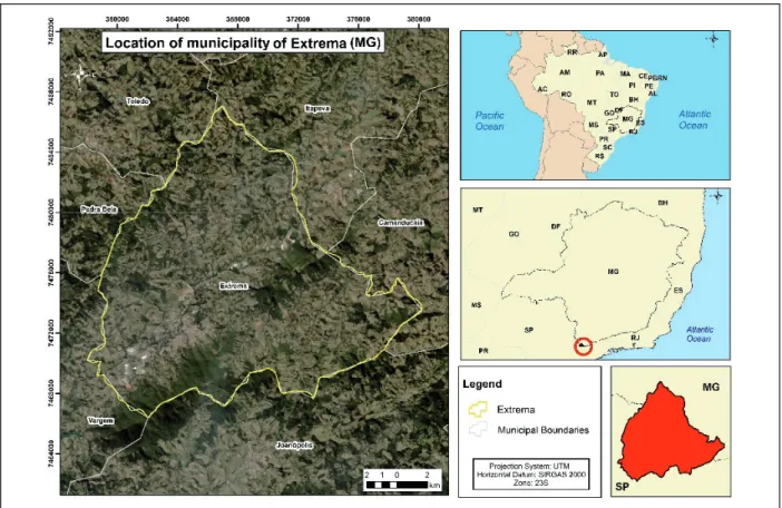
Extrema is located between the geographic coordinates 46º17’43” and 46º20’42” of West longitude and 22º43’6” and 22º 54’16” of South latitude (FIGURE 1). Its territory comprises around 243,09 km² and its climate is classified as temperate (Cfb), with mild summers and without occur-rence of dry season (ALVARES et al., 2013). During the year in Extrema, the rainfall is significant, presenting an annually average of 1.484 mm.
Figure 1 – Municipality of Extrema, Minas Gerais State.
Source: Elaborated by the authors (2018).
Subwatersheds: Forjos, Posses and Saltos
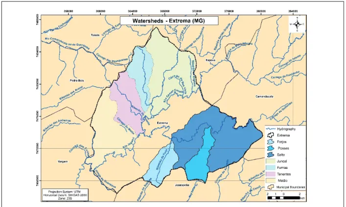
To implant the project “Conservador das Águas”, an analysis was conducted on the existing lite-rature and the 7 subwatersheds in the county were mapped, considering the most significant ones in the Jaguari watershed river: Forjos, Furnas, Juncal, Matão, Posses, Saltos and Tenentes (FIGURE 2). Pereira et al. (2016) mention that the chosen criteria to initiate the project was subwatersheds with the lowest groundcover from the upstream point to downstream of the county water catchment, in the following order: 1º- Posses, 2º- Saltos, 3º- Forjos, 4º- Juncal, 5º- Furnas, 6º- Tenentes, 7º- Matão. The first subwatersheds were studied in this article.
Figure 2 – Map of the division of the subwatersheds in the Jaguari river, Extrema (MG).
Source: Elaborated by the authors (2018).
The subwatershed of Ribeirão das Posses has an area of approximately 1.274,8 ha, and, before the project’s implantation, its springs and the remained preservation area were totally unprotected (PEREIRA et al., 2016). Groundcover was the most impacted criteria on the county, therefore it was chosen to initiate the project, in 2007.
Saltos subwatershed, which has 4.918,04 ha, is characterized by its large number of country houses and it is where you can find the largest properties in the county, the project was initiated in 2009.
Restoration work for the Forjos’ subwatershed, 1.312,50 ha, was started at the beginning of 2012 and has been carried out up to now. This was the most preserved watershed in the county for the groundcover’s criteria.
Methodology
For the mapping of the soil and groundcover’s use in the municipality of Extrema (MG), TM--Landsat-5 images were used in 2006 and OLI-Landsat-8 in the year of 2018, made available for free by National Aeronautics and Space Administration (NASA), in partnership with the United States Geological Survey (USGS), on the Earth Explorer’s page (USGS, 2018).
The methodology mentioned below was the same one used by Santos Junior and Costa (2015). For generating the colorful composition with the bands 2, 3 and 4, corresponding to blue, green and red respectively, the images were added to the platform ArcGIS at which the tool “Composite Bands” was used to generate the colorful composition. The reprojection of the available images by the sensor was necessary because they present “truth North” coordinates. For this, the tool “Project” was used, which inferred the South hemisphere parameters to the image. A spatial-cut tool was used, so we
could get a relative area for the municipality of Extrema (MG); after that step, the image was conver-ted from 16 to 8 bits to be worked in the SPRING software 5.5.3 version.
On the SPRING software, developed by the National Institute for Space Research (INPE), it was defined that the segmentation would be assigned by the region growth methodology. In this me-thod, it is necessary to establish the Similarities criteria (minimum number of differences for the levels of low gray, of which two classes are considered similar and grouped in the same region) and Area (minimum number of necessary pixels for the individualization of an area). In order to best separate the largest quantity of features in images, a number of thresholds was tested, assigning 10 for Simi-larity and 40 for Area. For this research, it was used the Bhattacharya5 algorithm for the supervised
classification6, choosing three different classes: “vegetation”, “urban” and “other uses”, being this last
one assigned to exposed soil “agriculture”, “pasture” etc.
After processing the information on SPRING, classifications, generation of the calculation for the area and percentage of use to each class and later the construction of the final layout were refined. All of these procedures were executed on ArcGIS software 10.5 version available by ESRI.
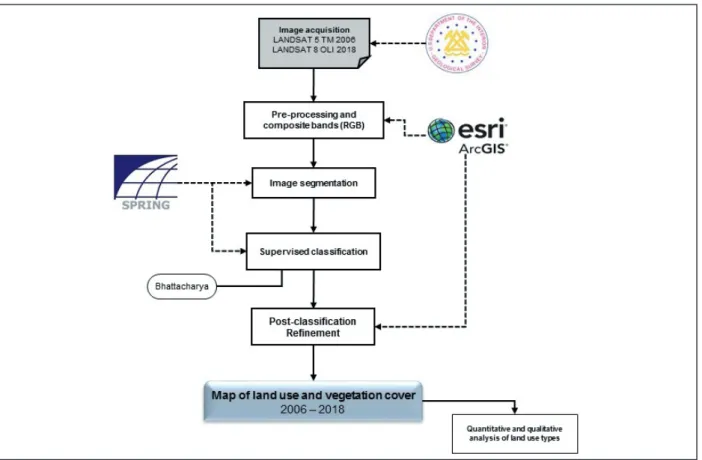
The procedures to obtain these mapping is shown in Figure 3.
Figure 3 – Flowchart that synthesizes the methodological procedures to the elaboration land use maps.
Source: Elaborated by the authors (2018).
5 The Bhattacharya algorithm works with the distance that is used to measure the statistics separability between a pair of classes, in other words, it measures the average distance between the distribution of probability of these classes (INPE, 2006).
6 The supervised classification is developed on basis of training samples, in other words, the image pixels are classified according to the rules. Afterwards these pixels are compared to the standard of previously obtained classes in a step in which the operator define them. Du-ring this process, an analyst identify in the image the information classes of his/her interest and separates the regions that better represent these classes.
R esults and discussion
The project “Conservador das Águas” has become an efficient environmental policy example for referring to the managing of the hydric resources, being an extremely important initiative, not only to the municipality of Extrema (MG) but also to the whole State of São Paulo, which depends on the water provided by the Cantareira System.
The short relationship between the rural owners and the adoption of environmental conserva-tion methods, as an example, the Permanent Preservaconserva-tion Areas (APP) and soil conservaconserva-tion practi-ces, are directly linked to the quantity and quality of available water from the maintenance of biodi-versity in these protected areas.
Thus, this article shows that the diligences to the preservation and recuperation of the environ-ment has a short-term return and that those results can be measured and evaluated by geoprocessing tools, which provide temporal data in an accessible way (PAULA et al., 2016).
According to Altmann Eckhardt and Rempel (2009), the disposal of satellite images of a same region of Earth and the computing tools on GIS allow the elaboration of comparation through the usage of temporal dimension as a quality of data acquired in different times.
Therefore, the digital classification of the used images in this article has allowed the quantifica-tion of the occurrence of classes of soil and groundcover usage of three pioneers subwatersheds to the implantation of the “Conservador das Águas” project, in the municipality of Extrema (MG), in 2006 and 2018, verifying the expansion or reduction of its occurrence at the final period.
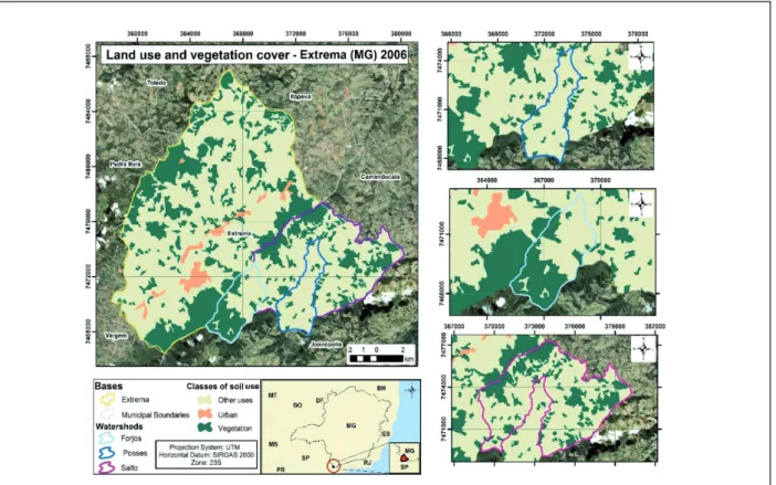
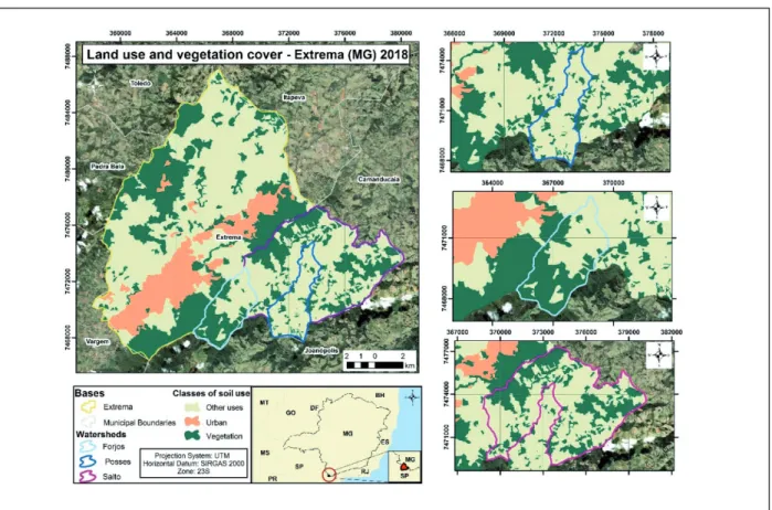
From the methodology used in this study, themed maps were generated from the mapped classes, at which we can identify and follow their evolution, by the quantification results (FIGURES 4 and 5). Figure 4 – Land use and vegetation cover maps of Extrema (MG) in 2006.
Figure 5 – Land use and vegetation cover maps of Extrema (MG) in 2018.
Source: Elaborated by the authors (2018).
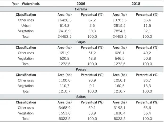
In the two analyzed periods, the total classes of soil and groundcover’s use are equal to 24.453,5 ha (TABLE 1), which is similar to the official area established by the Brazilian Institute of Geography and Statistics (IBGE, 2018) to the county, being 24.457,5 ha.
Despite the notable increase of the county’s vegetation, it is observed that some areas have been deforested. Table 1 shows the quantification in ha and the percentual for each subwatershed, as well as classes for soil’s use, to better identify and analyze the changes over the years analyzed in this study.
Table 1 – Classes of soil use adopted for the classification and quantification of areas in the years 2006 and 2018.
Year Watersheds 2006 2018
Extrema
Classifi cation Area (ha) Percentual (%) Area (ha) Percentual (%)
Other uses 16420,3 67,2 13783,6 56,4
Urban 614,3 2,5 2815,5 11,5
Vegetation 7418,9 30,3 7854,5 32,1
Total 24453,5 100,0 24453,5 100,0
Forjos
Classifi cation Area (ha) Percentual (%) Area (ha) Percentual (%)
Other uses 651,9 51,2 626,1 49,2
Vegetation 620,8 48,8 646,5 50,8
Total 1272,6 100,0 1272,6 100,0
Posses
Classifi cation Area (ha) Percentual (%) Area (ha) Percentual (%)
Other uses 1100,0 90,9 1050,1 86,7
Vegetation 110,7 9,1 160,5 13,3
Total 1210,7 100,0 1210,7 100,0
Saltos
Classifi cation Area (ha) Percentual (%) Area (ha) Percentual (%)
Other uses 3468,9 69,1 3192,1 63,6
Vegetation 1553,6 30,9 1830,4 36,4
Total 5022,5 100,0 5022,5 100,0
Source: Elaborated by the authors (2018).
It is important to highlight that the detection of changes in the use and soil cover through re-mote sensing allows to reconstruct how determined area was used in each period of time, making the understanding of the landscape dynamics possible, as well as its aspects and indicators of the environmental quality improvement (ALTMANN; ECKHARDT; REMPEL, 2009).
Thus, the collected data analyze has allowed us to observe that with respect to the “urban” class, in 2006, the municipality had an area of 614.3 ha, in 2015 the urban area corresponded to 1,452.73 ha (PAULA et al., 2016), increasing to 2,815.5 ha in 2018, there was a significant incre-ase, which currently represents 4.6 times the area of 2006.
This expansion in the urbanized area in the municipality of Extrema (MG) can be related to the establishment of big national and multinational industries that, attracted by the tax incentives offered by the county, have settled in the city offering jobs and attracting population from other Brazilian regions.
Fast urbanization process without proper urban planning causes groundcover withdrawal and soil leaching, generating many negative impacts to the physical aspects of a natural landscape.
A linear shortfall was observed to the classification of “other uses”, which comprehends the areas of agricultural activities, pasture, livestock, exposed soil areas etc. In 2006, the percentage to this category was around 67%. Paula et al. (2016), after performing a similar study, analyzed
changes in land use and claim that these changes corresponded to 59.0% in 2015. In 2018, in this study, agricultural activities, pastures, livestock and exposed soil areas corresponded to 56.0%, that is, despite the short-term evolution, the implementation of the project continues to show positive results over the years.
Considering the quantitative analyzes for the calculation, it was still possible to observe a decre-ase of 24,2 ha of the “vegetation” class to conversion of soil in urban area in the period of the studied area. Regarding the conversion of “vegetation” to “other uses”, a 1.139,61 loss of ha was registered for the county, which corresponds to 4,66% of its total area (TABLE 2).
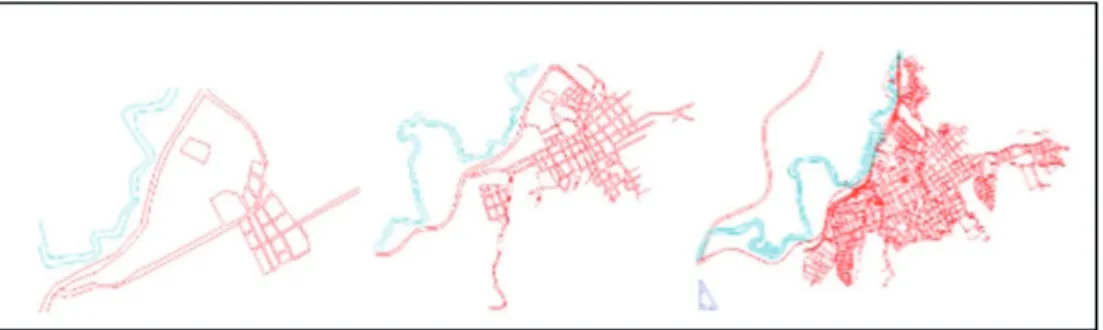
This decrease is also justified by the increase of population (FIGURE 6), and territorial expan-sion of the county during the time, due to the technological advances and industrial hubs settled in the city (FIGURE 7).
Figure 6 – Total population of Extrema (MG) between 1970 and 2007.
Source: Fonseca (2009).
Figure 7 – Maps of the urban area of Extrema (MG) of 1950, 1978 and 2003.
However, the increase of the “vegetation” class is a fact, since it had an increase of 2% of its total area, despite the conversions not only to urban area, but also to other uses.
Concerning the Ribeirão das Posses subwatershed, specifically, the class “vegetation” could be quantified in 110,7 ha in 2006, increasing to 106,5 ha after the implantation of the “Conservador
das Águas” project (TABLE 1). By comparing the maps, it was possible to observe a percentual of
deforestation, which, consequently, changed the class ‘vegetation” to “other uses”, corresponding to 25,28 deforested ha (TABLE 2).
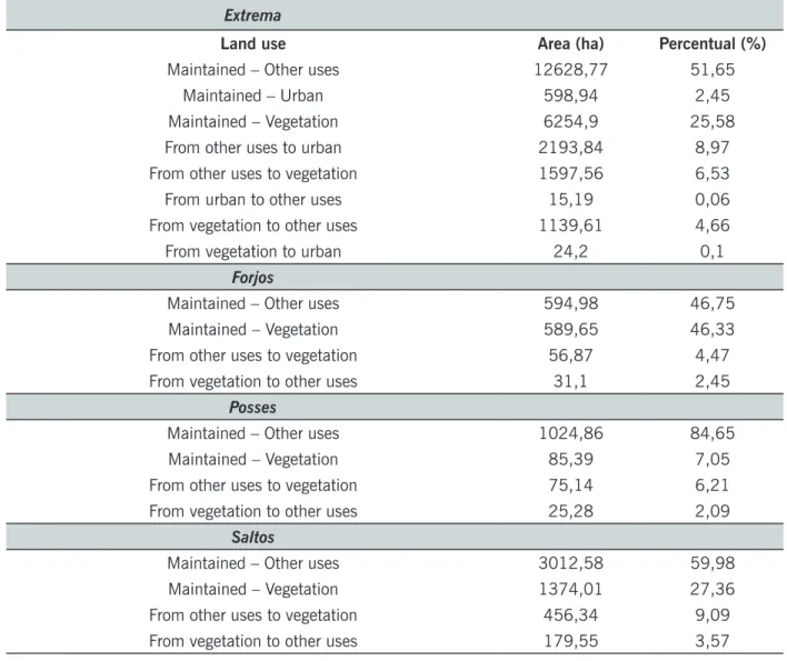
Table 2 – Land use change in Extrema (MG) and subwatershed of Forjos, Posses and Saltos between 2006 and 2018.
Extrema
Land use Area (ha) Percentual (%)
Maintained – Other uses 12628,77 51,65
Maintained – Urban 598,94 2,45
Maintained – Vegetation 6254,9 25,58
From other uses to urban 2193,84 8,97
From other uses to vegetation 1597,56 6,53
From urban to other uses 15,19 0,06
From vegetation to other uses 1139,61 4,66
From vegetation to urban 24,2 0,1
Forjos
Maintained – Other uses 594,98 46,75
Maintained – Vegetation 589,65 46,33
From other uses to vegetation 56,87 4,47
From vegetation to other uses 31,1 2,45
Posses
Maintained – Other uses 1024,86 84,65
Maintained – Vegetation 85,39 7,05
From other uses to vegetation 75,14 6,21
From vegetation to other uses 25,28 2,09
Saltos
Maintained – Other uses 3012,58 59,98
Maintained – Vegetation 1374,01 27,36
From other uses to vegetation 456,34 9,09
From vegetation to other uses 179,55 3,57
Source: Elaborated by the authors (2018).
According to Zolin et al. (2011), the deforestation is due to the scenario of land use and cover where the Posses subwatershed is located, which presents the highest annual soil loss due to a high degree of degradation of vegetation cover (mostly pastures). The lack of APP and RL (Legal Reserve), added to the presence of very steep areas, make it difficult to implement soil conservation practices.
In Forjos’ subwatershed, the vegetated area was quantified in 620,8 ha in 2006, and in 646,52 ha in 2018 (TABLE 1). For this subwatershed, there was also a change from the “vegetation” to the “other uses” class in about 2,45% (TABLE 2).
Saltos’ subwatershed presented more changes in terms of vegetated area, from 1.553,6 ha in 2006 to 1.830,4 ha in 2018 (TABLE 1). The change from the “vegetation” to “other uses” class in the studied period represented a quantified area of 179,55 ha, equivalent to 3,57% of deforestation to this subwatershed area (TABLE 2).
In a general analyzes perspective, it is important to highlight that the county has presented an increase in the conversion from “other uses” to “vegetation” class of 1.597,56 ha, even in the subwatersheds in which the project has not been implanted yet; in other words, 6,53% of the county area that was before destined to the agriculture, livestock, exposed soil and etc. were converted into arboreal vegetation (TABLE 2). According to Paula et al. (2016), this action can be associated to the increasingly incentive and awareness of the rural producers, as well as the appeal to recovering and preventing vegetation areas, thus reducing areas that were before destined to other kinds of activities.
The results obtained show us that, in the studied period, the quantification of the “other uses” class was converted into 19,77% to the “vegetation” class and it has presented 8,11% of defores-tation in the subwatersheds. The reduction in the conversion of the soil’s use of vegetated areas into “other uses” can represent the awareness of the rural producers to support environmental causes, due to the importance of the environmental biodiversity, the hydric resources and the conservation of the soil through the reforested areas, which were strengthened and has showed positive results since the implantation of the Project (PEREIRA et al., 2017).
Therefore, the importance and effectiveness of the “Conservador das Águas” project, through which groundcover restoration in the subwatersheds of Jaguari River, restoration of the natural areas and the increase of forest cover, even with the expansion of the urban area, have reflected a decrease of areas used to other activities, such as agriculture, livestock etc., thus guaranteeing the environmen-tal improvement of all ecosystem around the county.
This evolution affects directly the maintenance of the local biodiversity and the functioning of the whole hydric system of the region, improving seepage, percolation and water storage procedures, decreasing the subsurface runoff and also the erosion, (BALBINOT et al., 2008; LIMA, 1996; SAN-TOS et al., 2007; DUDLEY; STOLTON, 2003). The presence of vegetation cover directly influences the reduction of sediment loads in the waterways, reducing the sedimentation processes, with a con-sequent improvement in the quality of water available for consumption (JARDIM; BURSZTYN, 2010). These factors have resulted in the satisfaction of the rural producers (ZANELLA, 2011), motivating them to maintain or restore the vegetation cover of their properties, with a consequent improvement in water quality, and effective provision of environmental services to the county and to their properties.
Furthermore, the project offers work opportunities, trains workforce to forest restoration, soil conservation practices and environmental leaching (PAGIOLA; VON GLEHN; TAFFARELLO, 2013).
Conclusion
The project “Conservador das Águas” was environmentally efficient, due to the native vegeta-tion restoravegeta-tion in the subwatershed areas, which promotes an improvement of environmental quality.
Evolução do uso da terra e da cobertura vegetal nas sub-bacias
hidrográficas pioneiras do projeto “Conservador das Águas” (2006-2018)
Resumo
Neste trabalho, avaliamos mudanças espaço-temporais ocorridas em três sub-bacias hidrográ-ficas essenciais para a hidrodinâmica do Rio Jaguari (Ribeirão das Posses, Forjos e Saltos) após a implantação do projeto “Conservador das Águas” no município de Extrema (MG). Utilizamos imagens dos satélites TM-Landsat-5 no ano de 2006 e OLI-Landsat-8 no ano de 2018 para mapear o uso da terra e cobertura vegetal, e o software SPRING para classificar as imagens em Sistemas de Informa-ção Geográfica (SIG) e quantificar a ocorrência das classes analisadas nos anos de 2006 e 2018. Após as análises, observamos um aumento de 19,77% de cobertura vegetal nas três sub-bacias. Além disso, para nossa surpresa, observamos um resultado semelhante em sub-bacias adjacentes nas quais o projeto não havia sido implementado. Este estudo sugere um efeito positivo do projeto “Conservador das Águas” para a manutenção da biodiversidade e funcionamento do sistema hídrico da região, resultando na melhoria do padrão de qualidade ambiental e efetivação da prestação de serviços ambientais no município e em suas propriedades.
Palavras-chave: Análise espaço-temporal. Classificação supervisionada. Bhattacharya.
References
AGÊNCIA DAS BACIAS PCJ. Relatório de gestão das Bacias PCJ - 2013. Disponível em: <http://
www.agenciapcj.org.br/docs/relatorios/relatorio-gestao-bacias-pcj-2013.pdf.> Acesso em: 15 abr. 2019.
ALTMANN, A. L.; ECKHARDT, R. R.; REMPEL, C. Evolução temporal do uso e cobertura da Terra – estudo de caso no município de Teutônia – RS – Brasil. Revista Brasileira de Cartografia, v. 61, p. 273-283, 2009.
ALVARES, C. A.; STAPE, J. L.; SENTELHAS, P. C.; GONÇALVES, J. L. M.; SPAROVEK, G. Köppen’s climate classification map for Brazil. Meteorologische Zeitschrift, v. 22, n. 6, p. 711-728, 2013. Disponível em: <http://www.lerf.eco.br/img/publicacoes/Alvares_etal_2014.pdf>. Acesso em: 11 jul. 2019.
BALBINOT, R.; OLIVEIRA, N. K.; VANZETTO, S. C.; PEDROSO, K.; VALERIO, A. F. O papel da flo-resta no ciclo hidrológico em bacias hidrográficas. Revista Ambiência. Guarapuava, PR, v. 4, n. 1, p. 131-149, 2008. Disponível em: <http://www .redeacqua.co m.br/wp-content/uploads/2011/09/ PAPEL-DA-FLORESTA.pdf>. Acesso em: 10 jul. 2018.
BUENO, E. Capitães do Brasil: A Saga dos Primeiros Colonizadores. Coleção Terra Brasilis, 3 ed. Rio de Janeiro: Objetiva, 2006.
CAMPOS, J. M.; NEVES, S. M. A. S. Cobertura vegetal e uso da terra na bacia hidrográfica do rio Paraguai/Jauquara-MT. In: JORNADA CIENTÍFICA DA UNEMAT, 2., 2009, Barra do Bugres, MT. Anais.... Barra do Bugres, 2009. 1 p.
DEAN, W. A ferro e fogo: a história e a devastação da Mata Atlântica brasileira. São Paulo: Cia das Letras, 1996.
DUDLEY, N.; STOLTON, S. Running Pure: The Importance of Forest Protected Areas to Drinking Water. World Bank/WWF Alliance for Forest Conservation and Sustainable Use. Gland, Switzerland: WWF International, 2003. Disponível em: <http://siteresources. worldbank.org/intbiodiversity/re-sources/runningpure2003+.pdf>. Acesso em: 09 jul. 2018.
FONSECA, C. E. O crescimento e a expansão urbana e industrial no município de Extrema, Minas Gerais, a partir da duplicação da Rodovia Fernão Dias, BR 381. (Mestrado em Geografia – 2009). Pontifícia Universidade Católica de São Paulo, PUC-SP.
INSTITUTO BRASILEIRO DE GEOGRAFIA E ESTATÍSTICA – IBGE. Cidades: Extrema - MG. 2018. Dis-ponível em: <https://cidades.ibge.gov.br/brasil/mg/extrema/ panorama>. Acesso em: 19 jul. 2018. INSTITUTO DO MEIO AMBIENTE E DOS RECURSOS NATURAIS RENOVÁVEIS – IBAMA. Pagamen-tos por Serviços Ambientais na Mata Atlântica: lições aprendidas e desafios / Fátima Becker Guedes e Susan Edda Seehusen; Organizadoras. – Brasília: MMA, 2011. 272p.
INSTITUTO NACIONAL DE PESQUISAS ESPACIAIS – INPE. SPRING: Tutorial de
Geopro-cessamento. 2006. Disponível em: <http://www.dpi.inpe.br/spring/portugues/tutorial/index.
html>. Acesso em: 01 jun. 2019.
JARDIM, M. H.; BURSZTYN, M. A. Pagamento por serviços ambientais na gestão de
recur-sos hídricos: o caso de Extrema (MG). Revista Engenharia Sanitaria e Ambiental, v. 20, n. 3,
p.353-360, set. 2015. Disponível em:
<http://www.scielo.br/pdf/esa/v20n3/1413-4152-e-sa-20-03-00353.pdf>. Acesso em: 23 jul. 2019.
LIMA, C. E. S.; GOMES, D. D. M.; GOLDFARB, M. Detecção de mudanças na cobertura
vegetal da bacia hidrográfica do Rio Inhaúma–PE/AL, por meio de técnicas de
Geoprocessa-mento e dados de SensoriaGeoprocessa-mento Remoto. Revista de Geociências do Nordeste, v. 2, 2016.
MATTEI, L; ROSSO, S. Evolução do mercado de pagamento por serviços ecossistêmicos no
Brasil: evidências a partir do setor hídrico. In: IPEA. Boletim Regional, Urbano e Ambiental,
Brasília, 2014. Disponível em: <http://repositorio.ip ea.gov.br/bitstream /11058/5562/1/
BRU_n09_evolucao.pdf>. Acesso em: 04 ago. 2018.
OMURA, P. A. C.; CAMPOS, D. R.; DIEDERICHSEN, A. T. B.; MENEZES, J. P. A.; CAVICHIA, A.; PA-DOVEZI, A. Conhecendo as águas e a saúde do rio Jaguari – Uma proposta de trabalho pedagógico abordando a conservação e qualidade dos recursos hídricos. II Simpósio – Experiências em Gestão dos Recursos Hídricos por Bacia Hidrográfica. 2010.
PAGIOLA, S.; VON GLEHN, H. C.; TAFFARELLO, D. Experiências de pagamentos por serviços ambientais no Brasil. São Paulo: Secretaria do Meio Ambiente/Coordenadoria de Biodiversidade e Recursos Naturais, 2013.
PAULA, S. L.; MACIEL, D. A.; TEIXEIRA, V. E.; PAULA, J. C. A.; GONÇALVES, T. G.; ALVES, M. C. Avaliação do “Programa Conservador de Água’’ no município de Extrema/MG, através de técnicas de sensoriamento remoto. In: XIV ENEEAmb, II Fórum Latino e I SBEA – Centro-Oeste. Anais.... Brasília, 2016.
PEREIRA, P. H.; CORTEZ, B. A.; ARANTES, L. G. C.; PEREIRA, K. H.; OMURA, P. A. C.; RODRIGUES, R. R. Conservador das Águas: 12 anos. Edição 2017. Extrema: Departamento de Meio Ambiente, 2017. 187p. Disponível em: <http://extrema.mg.gov. br/conservadordasaguas/conservador-das-a-gua-livro-12-anos.pdf>. Acesso em: 23 jul. 2018.
PEREIRA, P. H.; CORTEZ, B. A.; OMURA, P. A. C.; ARANTES, L. G. C.; Projeto Conservador das Águas. Extrema: Departamento de Meio Ambiente, 2016. 37p. Disponível em: <http://www.extre-ma.mg.gov.br/conservadordasaguas/Projeto-Conservador-das-aguas-versao-fevereiro-de-2016.pdf>. Acesso em: 23 jul. 2018.
RIBEIRO, M. C., METZGER, J. P., MARTENSEN, A. C., PONZONI, F. J.; HIROTA, M. M. The Brazilian Atlantic Forest: How much is left and how is the remaining forest distributed? Implications for conser-vation. Biological Conservation, v. 142, p.1141-1153, 2009.
SANTOS, G.V.; DIAS, H. C. T.; SILVA, A. P. S.; MACEDO, M. N. C. Análise hidrológica e socioam-biental da bacia hidrográfica do córrego Romão dos Reis, Viçosa- MG. Revista Árvore, v.31, n. 5, 931-940 p. 2007. Disponível em: <http://www.scielo. br/pdf/rarv/v31n5/a17v31n5.pdf>. Acesso em: 09 jul. 2018.
SANTOS JUNIOR, W. M. ; COSTA, V. C. Práticas no Ensino de Geoprocessamento: Pré-Processamen-to com Bandas Multiespectrais de Imagens do Sensor Landsat 8. 2015.
SOS MATA ATLÂNTICA.; INSTITUTO NACIONAL DE PESQUISAS ESPACIAIS – INPE. Atlas dos rema-nescentes florestais da Mata Atlântica: Período 2016-2017. São Paulo: SOS, 2018. Disponível em: <https://www.sosma.org.br/link/Atlas_Mata_ Atlantica_2016-2017_relatorio_tecnico_2018_final. pdf>. Acesso em: 18 jul. 2018.
TEIXEIRA, C. G. Pagamento por serviços ambientais de proteção às nascentes como forma de sus-tentabilidade e preservação ambiental. 2011. 198p. Dissertação (Pós-Graduação). Pontifícia Uni-versidade Católica do Paraná (PUC-PR), Curitiba. Disponível em: <http://produtordeagua.ana.gov. br/Portals/0/DocsDNN6/documen tos/PSA%20pela%20conserva%C3%A7%C3%A3o%20das%20 nascentes%20Carlos%20Geraldo%20Teixeira.pdf>. Acesso em: 31 jul. 2018.
UNITED STATES GEOLOGICAL SERVICE – USGS. Earth Explorer - Collection - Landsat Archive. Dis-ponível em: <http://earthexplorer.usgs.gov/>. Acesso em 21 jul. 2018.
VEIGA NETO, F. C. A. Construção dos mercados de pagamentos por serviços ambientais e suas implicações para o desenvolvimento sustentável no Brasil. 2008. Tese (Doutorado). Universidade Federal Rural do Rio de Janeiro – UFRRJ, Rio de Janeiro. Disponível em: <https://tede.ufrrj.br/jspui/ bitstream/tede/714/1/2008%20-%20Fernando%20Cesar%20da%20Veiga%20Neto.pdf>. Acesso em: 20 jul. 2018.
ZANELLA, M. A. Conservador das Águas, Extrema: Resultados de pesquisa. Humboldt-Universität zu Berlin. 2011. Disponível em: <https://www.ciliosdoribeira.org.br/sites/ciliosdoribeira.org.br/files/ arquivos/Resultados_PSA_Extrema.Jul11%28MAZ%29.pdf>. Acesso em: 17 jul. 2019.
ZOLIN, C. A.; FOLEGATTI, M. V.; MINGOTI, R.; SÁNCHEZ-ROMÁN, R. M.; PAULINO, J.; GONZÁLES, A. M. G. O. Minimização da erosão em função do tamanho e localização das áreas de floresta no con-texto do programa “Conservador das Águas”. Revista Brasileira de Ciência do Solo, v. 35, n. 6, 2157-2166 p., 2011. Disponível em: <https://dx.doi.org/10.1590/S0100-06832011000600030>. Acesso em: 17 mar. 2019.
Received in: April 25, 2019 Accepted in: August 12, 2019